
 "Monsoon Mayhem: THESE Indian states are experiencing severe rains")
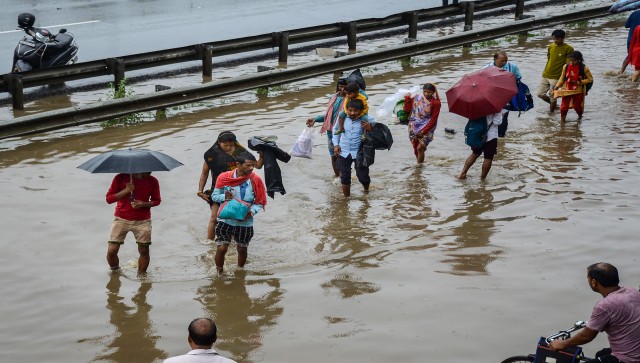
After a storm comes the rain. The monsoon arrived a little later than usual this year, providing relief from the searing temperatures in certain parts of India on Sunday. Notably, rain fell in both the national capital Delhi and the financial hub Mumbai on the same day for the first time since 1961. The monsoon arrived in Mumbai two weeks later than normal, but it started in Delhi two days sooner than typical, according to the India Meteorological Department (IMD). As per IMD, severe
Cyclone Biparjoy appeared to have a negative impact on the monsoon in southern India as well as the neighbouring western and central parts of the nation. The
monsoon's course this year was rather unique, with the rainfall activity across Delhi, Chandigarh, and Haryana being termed as “vigorous.” Let’s take a closer look at parts of India witnessing heavy rains. Delhi On Sunday, the National Capital was hit by heavy rain, which caused the minimum temperature to drop to 23.7 degrees Celsius, four degrees below average, according to IMD. The Safdarjung Observatory said the city received 48.3 mm of rain up until 8:30 am. The maximum temperature in the city will be approximately 32 degrees Celsius on Sunday, according to IMD’s forecast, which also calls for a gloomy sky and moderate rainfall. The high temperature on Saturday was 37.2 degrees Celsius, and the low was 30.4 degrees Celsius. An orange alert has been issued for Delhi for today. While, a yellow alert has been issued for Wednesday, 27 June, and Thursday, 28 June. [caption id=“attachment_12788432” align=“alignnone” width=“640”] The monsoon’s course this year was rather unique, with the rainfall activity across Delhi, Chandigarh, and Haryana being termed as “vigorous.” Graphic: Pranay Bhardwaj[/caption] Maharashtra According to the officials, Mumbai and its surrounding areas experienced severe rain during the previous 24 hours, which caused waterlogging in several parts and hampered traffic on some highways. Up until 8.30 am on Sunday, the Colaba observatory said the island city recorded 86 mm of rainfall. Similar to the Santacruz weather station, which represents the suburbs, the IMD reported that 176.1 mm of rain fell during the same time period. Maharashtra chief minister Eknath Shinde reviewed the effectiveness of a water tank at the Milan underground to prevent floods and expressed satisfaction with how well it was working, according to Hindustan Times. Additionally, Raigad and Ratnagiri in Maharashtra have received an “orange” alert (heavy rains from 60 mm to 200 mm) from the IMD. Haryana and Punjab According to
IMD , rain fell in a number of locations in Punjab and Haryana on Sunday, which caused the minimum temperature to drop. Rainfall was recorded in locations like Ambala, Karnal, Narnaul, Rohtak, Bhiwani, Gurugram, Kurukshetra, and Mohali throughout the course of a 24-hour period ending at 8:30 on Sunday. In Panchkula, locals helped a woman who was trapped in a car that had been carried away in a river.
#WATCH | Haryana | A woman's car swept away due to a sudden excessive water flow in the river due to rain in Kharak Mangoli, Panchkula. The car was parked near the river. The woman had arrived here to offer prayers at a temple. She has been admitted to a hospital. Efforts to… pic.twitter.com/UlCcsuqNH1
— ANI (@ANI) June 25, 2023
Himachal Pradesh At least eight vehicles in Kullu sustained damage as a result of the heavy downpours in Himachal Pradesh. According to the state emergency operation centre, twenty highways were shut due to severe rain, including the National Highway 5 near Theog in Shimla. Due to the probability of isolated portions of the state experiencing heavy to very heavy rainfall, lightning, and thunderstorms, the IMD has issued an orange advisory for Sunday and Monday. A yellow alert for 27 and 28 June is also listed in the daily bulletin from the meteorological department, suggesting the potential of thunderstorms and lightning on those days. [caption id=“attachment_12788652” align=“alignnone” width=“640”] Damaged vehicles after they got swept away in floodwater following heavy rainfall, in Kullu. PTI[/caption] Jammu and Kashmir The monsoon has a good chance of moving further into sections of Jammu and Kashmir. Due to heavy rainfall in Mendhar in the Poonch district, flash floods occurred in the state’s Harni Nallah region.
#WATCH | J&K: Flash flood in Harni Nallah witnessed due to heavy rainfall of Mendhar in Poonch. One person was rescued by people. pic.twitter.com/CeIfJDTHG2
— ANI (@ANI) June 25, 2023
Assam According to the Assam Disaster Management Authority (ASDMA), the flood situation in Assam has slightly improved, although 4.01 lakh people in 15 districts are still being affected. In 42 revenue circles spread throughout Bajali, Baksa, Barpeta, Chirang, Darrang, Dhubri, Dibrugarh, Goalpara, Golaghat, Jorhat, Kamrup, Lakhimpur, Nagaon, Nalbari, and Tamulpur districts, 1,118 villages were impacted by the deluge. Due to significant rainfall, the Brahmaputra River is currently beyond the danger mark at Neamatighat in the Jorhat district and at Tezpur in the Sonitpur district.
IMD has forecasted significant precipitation over northeast India over the next four days as well as over portions of East India for the upcoming day. On 28 and 29 June, heavy to very heavy rainfall is expected in Assam, Meghalaya, and Arunachal Pradesh. Uttarakhand Haridwar received 78 mm of rain in the last 24 hours, followed by Dehradun (33.2) and Uttarkashi (27.7), according to IMD. Heavy rain also pummels certain areas of the Himalayan state. According to a press release, Uttarakhand Chief Minister Pushkar Singh Dhami conducted a surprise inspection of the State Disaster Management Control Room on Sunday and learned more about the situation with the state’s severe rains. Livemint reported two people died in rain-related events in Uttarakhand on Sunday as torrential rains pounded the state and the Met Office issued an “orange alert” for multiple districts. Madhya Pradesh The eastern parts of Madhya Pradesh are now under the influence of the southwest monsoon, which has brought rainfall over the previous 24 hours. By 28 and 29 June, according to an IMD official, the rainy weather pattern is expected to cover the entire state of Madhya Pradesh. East Madhya Pradesh has also received an orange alert. Rainfall from large to very heavy amounts can also happen in remote areas of the West. “The monsoon forayed into MP from its eastern part, bordering Chhattisgarh, on Saturday evening. The fast-moving rain-bearing system covered the entire MP, including its western part, home to state capital Bhopal by Sunday afternoon,” IMD Bhopal centre director R Balasubramanian told PTI. Odisha For various districts in Odisha, the India Meteorological Department (IMD) has issued a heavy rainfall warning till 27 June. In Cuttack, Jajpur, Dhenkanal, Keonjhar, and Mayurbhanj, it was predicted that heavy rain might occur in one or two locations on Saturday. On Thursday, the southwest monsoon began to affect sections of the districts of Malkangiri, Koraput, and Gajapati before moving on to blanket the entire state. In Balasore, Bhadrak, Kendrapada, Jagatsinghpur, Khordha, Puri, Nayagarh, Angul, Kandhamal, Boudh, Sonepur, Sambalpur, Deogarh, and Sundargarh, heavy rain (7-11 cm) is also very likely to fall at one or two locations, according to India Today. Gujarat and Rajasthan Over the course of the next four days, Saurashtra, Kutch, and the Gujarat region will get light to moderately widespread to widespread rainfall. From 26 to 29 June, Gujarat State is also anticipated to see heavy rain. On 28 June, East Rajasthan is expected to receive heavy to very heavy rain with the possibility of extremely severe falls, in addition to heavy to very heavy rain from 26 to 29 June. Jharkhand On 19 June, the southwest monsoon arrived in Jharkhand, and by Friday, it had reached 23 of the state’s 24 districts. Additionally, the weather service has issued a heavy rainfall warning for certain regions of the state for 25 and 26 June. Tamil Nadu According to IMD, last Tuesday brought rain and thunderstorms to several areas of Tamil Nadu. Chennai and other regions of Tamil Nadu experienced severe rainfall, prompting authorities to declare a holiday for schools last Monday. Morning office-goers had a hard time braving the downpour amid traffic snarls in some parts of the city. Trees were uprooted in areas including Ekkatuthangal, Adyar and Nanganallur and the city civic body was clearing them, Chennai Airport received the highest of 16 cm of rainfall during the 24-hour period ending at 8.30 am on 19 June, the regional weather office said. With inputs from PTI Read all the Latest News , Trending News , Cricket News , Bollywood News , India News and Entertainment News here. Follow us on Facebook, Twitter and Instagram.
 "Russian drones over Poland: Trump’s tepid reaction a wake-up call for Nato?")
 "As Russia pushes east, Ukraine faces mounting pressure to defend its heartland")
 "Why Mossad was not on board with Israel’s strike on Hamas in Qatar")
 "Turkey: Erdogan's police arrest opposition mayor Hasan Mutlu, dozens officials in corruption probe")


