
 "MapMyIndia launches Street View rival RealView, AI assistant Hey Maps, and \"Aadhaar for locations\" eLoc")
MapMyIndia made a number of announcements at the Map The Future conference held in Gurugram on 17 April 2017. MapMyIndia provides high quality mapping services for the country, for addressing the problems that are unique to India. Companies that use MapMyIndia technologies integrated into their offerings include Ola, Avis, Idea, Flipkart, Amazon, Ola, Uber and the State Bank of India. The conference had keynotes and panel discussions on the increasing importance of high quality location data, the roadmap to getting self driving cars to work in India, and how mapping data can be used to better deliver Governance to the citizens of the country.
Real View
One of the biggest ideas presented at the conference was the project ‘Real View service’ which hopes to create a digital twin of the real world, with a virtual recreation of India. The technologies used for this include cars mounted with 360 degree cameras, drones and laser based sensors. MapMyIndia is going indoors as well, to provide mapping services for warehouses, stadiums, malls, and factories. MapMyIndia plans to update the digital twin with 360 degree cameras mounted on backpacks, trains and trolleys, apart from drones and cars.
Real View can be updated constantly, in realtime, from professional surveyors, as well as crowdsourced reports. This is allowed through the agency of the InTouch platform, which can analyse high quality video streams in realtime, using computer vision and machine learning techniques. Essentially, Real View is an annoted and constantly updated video map of the real world.
MapMyIndia announced the acquisition of Bengaluru based video mapping firm, Vidteq. Vidteq is one of the pioneers of video mapping technologies in India, and has mapped over twenty cities in the country. Vidteq aims to provide high quality location and direction information for businesses, including builders, the hospitality industry and educational institutions.
Chandra Thimmannagari, Founder and CEO at Vidteq said, “We are extremely excited to be acquired by MapMyIndia. We believe it’s a perfect match. We are the pioneers in VideoMaps. By joining hands with MapMyIndia, who are the leaders in digital maps and location technologies, we would like to together build next generation Advanced VideoMaps that can power Autonomous Vehicles.”
Rohan Verma, Chief Technology Officer of MapMyIndia said, “The next generation of our revolutionary Real View service, wherein we are pioneering building of the first Digital Map Twin of the Real World, powered by our technology building and acquisition efforts, is unprecedented, universal and overarching. It will be an all India map of the outdoor and indoor, in 360 degree and 3D, highly accurate and updated live, available in all local languages, captured from the ground as well as the skies, where each place and object is given a unique, simple, standardised identity, that we call eLoc.”
eLoc codes
eLoc codes hopes to be for addresses, what Aadhaar is for people. Just like every person in India is assigned with a number, the eLoc code allows every doorstep in India to be assigned a six digit number. The concept is a more granular version of a PIN code. Just like every locality has a PIN code, MapMyIndia wants to assign every address in India with an easy to remember alphanumeric string. One of the major problems being addressed is the failure of conventional mapping technologies to hold up for the last mile. It is still required to ask for directions to get to a place.
Indian addresses are complex, can be in a number of languages and have variations in spelling. eLoc hopes to provide a standardised digital address, that is accurate to the doorstep. Anyone can generate an eLoc code for an address, but the information is later verified by MapMyIndia. There are already over 2 crore eLoc numbers, and the count is increasing. Eventually, MapMyIndia hopes to give every door in India an eLoc code. The code can be shared with friends, family and businesses easily, reducing long addresses to just six characters.
The India Stack allows for on demand access to a number of services. There are a number of layers in the India Stack, including a consent layer, a cashless layer, a paperless layer and a presence-less layer. There is a location layer missing in the services, and MapMyIndia wants to provide the citizens of the country and the Government with this missing layer.
Hey Map app
MapMyIndia has tied up with Reverie to offer a localised mapping oriented digital assistant called “Hey Map”. Reverie is one of the leading provider of language technology solutions. The Hey Map app is currently available in Hindi, and MapMyIndia plans to roll out the service in other languages very soon. Users can interact with the app using natural language, either through text chats, or through spoken word.
The spoken word interactions are powered by a speech to text engine, which converts voice inputs to a text chat automatically. It is possible to share the exact location with friends and family using the eLoc code from within the Hey Map app. The exact locations of known places can also be searched for, which benefits from the accuracy offered by the eLoc codes.
Arvind Pani, Co-Founder & CEO of Reverie Language Technologies said, “MapmyIndia has been a frontrunner in enabling accurate digital map usage in India. However, since India is a country where only 4 percent Indians are fluent in English and the dialect changes every 40 kilometres, it becomes imperative to take languages into account for enabling a truly efficient navigation solution. We hope this will be used extensively by businesses, the government and Indians for a truly delightful experience in a language of their choice.”
Other announcements at the conference included Udacity and MapMyIndia entering into a strategic partnership to strengthen the self driving car ecosystem in the country. Over ten percent of those who take the automated cars course in Udacity are Indians.
Aatapaha , an LED lighting company discussed plans to implement smart street lighting in cities. These smart street lights would allow for savings of up to 80 percent of the energy used, by dimming street lights to 20 percent of their power when there is no one on the roads.
MapMyIndia is tying up with Isro to combine satellite imagery from Isro with MapMyIndia data for the Navic platform, which will reduce the dependence of India on foreign location service providers. Idea Cellular is collaborating with MapMyIndia with innovative services for logistics companies. Disposable and temporary SIM cards can be used to track cargo transport vehicles. The innovative solution is made for India, where the ownerships of fleets are fragmented, and vehicle owners do not want to bear the cost of permanent positioning systems on their vehicles.


 "Israel missing from Chinese digital maps")
 "MapmyIndia IPO to open on 9 December; price band set at Rs 1,000-1,033 per share")
 "Google Maps to get a COVID-19 layer that will show virus affected areas using colour codes")
 "An assault on the map: why the dispute between India and China in Ladakh may continue to escalate")
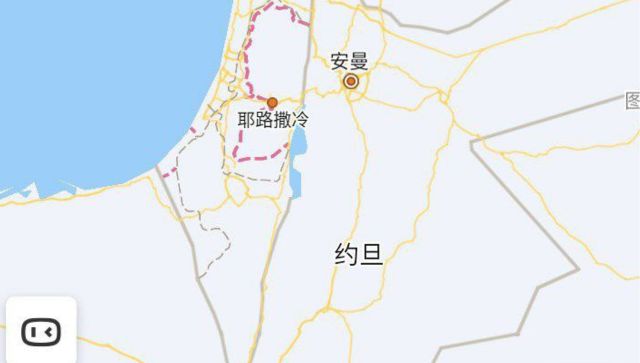 "Israel missing from Chinese digital maps")
 "MapmyIndia IPO to open on 9 December; price band set at Rs 1,000-1,033 per share")
 "Google Maps to get a COVID-19 layer that will show virus affected areas using colour codes")
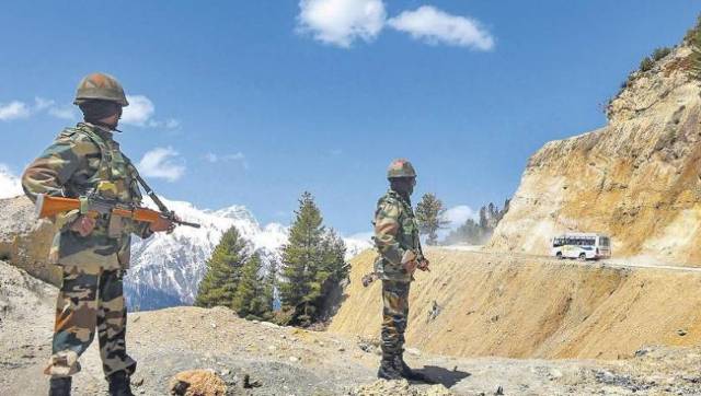 "An assault on the map: why the dispute between India and China in Ladakh may continue to escalate")