The Weather Report: After a slow start monsoon seems to be in a hurry to cover the west coast of India
Monsoon onset over Kerala was very weak and it struggled to advance further in other parts of India in the last two weeks. Finally this weekend, the revival of monsoon is observed on the West Coast of the country where a sudden increase in rainfall is observed. The credit for the pick up of the monsoon goes to the strengthening of Westerly winds along with the formation of Offshore troughs in Maharashtra and Karnataka Coast which results in the formation of rain clouds. After a slow start monsoon seems to be in a hurry to cover the west coast of India. On Friday, Goa received its first monsoonal showers and similarly on Saturday Indian Meteorological Department declared the onset of monsoon in Mumbai – the financial capital of India. The main observatories i.e., Santacruz recorded 41mm rainfall on Saturday and 23mm Rainfall ending 8:30am on Sunday morning, the much-awaited good rains have arrived. Goa-Maharashtra rainfall in the 24 hours till 8:30am on 12 June: Mormugao – 181mm Panaji – 127mm Mumbai CSMT – 88mm Akola – 45mm Ratnagiri – 30mm Dahanu – 29mm Mumbai Santacruz – 23mm Parbhani – 21mm Buldhana – 18mm Nanded – 13mm Yevatmal – 13mm Kolhapur – 12mm Mahabaleshwar – 9mm Thane Rabale – 6mm Pune – 2mm As the data reflects the monsoon is most active in Goa and Maharashtra coast as the offshore trough is strongest at these spots at the moment. As per the India Meteorological Department, the Northern Limit of Monsoon (NLM) continues to pass through Lat. 20°N/ Long. 60°E, Lat. 20°N/Long. 70°E, Dahanu, Pune, Gadag, Bengaluru, Puducherry, Lat. 14°N/ Long. 84°E, Lat. 17.0°N/ Long. 87°E, Lat.20.0°N/89.5°E, Lat.22.0°N/90°E, Lat.25.0°N/89°E, Siliguri and 27.50°N/88°E. [caption id=“attachment_10790531” align=“alignnone” width=“640”]
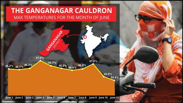
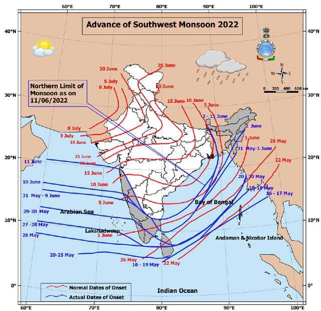 Progress of Monsoon till 11 June 2022 as per IMD[/caption] Conditions are favorable for further advance of monsoon into some parts of north Arabian sea,remaining parts of Konkan, some parts of Gujarat state, most parts of Madhya Maharashtra, entire Karnataka and Tamil Nadu, some parts of Telangana, Andhra Pradesh, Westcentral & northwest Bay of Bengal during next 24 hours. Conditions would continue to become favourable for further advance of monsoon into some more parts of north Arabian Sea, Gujarat state, some parts of Marathwada, some more parts of Telangana, Andhra Pradesh, most parts of Bay of Bengal, entire Sub-Himalayan West Bengal and Sikkim, some parts of Odisha, Gangetic West Bengal, Jharkhand and Bihar during the subsequent two days. North East India continues to drench under extreme rains. Cherrapunji recorded a whopping 354mm rainfall in the last 24 hours ending 8.30am on 12 June. Annual rainfall so far crossed the 6,100mm mark at one of the wettest places on earth. Overall rainfall events are increasing across Central and East India now as pre-monsoon thundershowers are lashing the region now. Indore in Madhya Pradesh recorded 48mm ending 8.30am on 12 May, following the pre-monsoon rains dip in temperature was observed as the city recorded 21.8°C minimum temperature. Similarly, Surat in Gujarat experienced 43mm rainfall ending 8.30am on Sunday morning and eventually, IMD may declare monsoon onset in some parts of Gujarat today. North India continues to experience unprecedented heat waves. Day temperatures are above 40°C across Punjab, Haryana, Rajasthan, Delhi NCR and Uttar Pradesh and above 45°c in patches, The plains have not witnessed any significant rainfall in the last 10 days, Also the night temperatures are above 30°C in many stations during the past week. Delhi Safdarjung recorded 32.8°c minimum temperature on Sunday observing the warmest night and morning of the season so far. The departure is +5°c above normal, making the nights unbearable across the region. To get more insights on Heatwave in North-West India, here is the June’s Daily Maximum temperature data from Ganganagar in Rajasthan so far: 1st – 46.2°C 2nd – 46.1°C 3rd – 46.3°C 4th – 47.5°C 5th – 46.7°C 6th – 46.3°C 7th – 46.0°C 8th – 46.2°C 9th – 47.0°C 10th – 45.0°C 11th – 44.4°C The ongoing long-lasting spell of Heatwave is severely impacting the growth of cotton crop in the cotton belt which is Malwa region of Punjab, North Rajasthan and Western Haryana.
![Ganganagar(1)]()
As per IMD data, total Monsoon seasonal rains in India since 1 June till 11 June: • India as a whole recorded a total of 23.0mm rainfall against the average of 40.1mm, departure from normal Stands at -43 er cent. • Southern Peninsula: Actual 30.9mm against the average of 49.6mm, -38 per cent departure from normal. • East and North East India: Actual 88.4mm against the average of 93.3mm, -5 per cent departure from normal. • North West India: Actual 1.9mm against the average of 16.9mm, -89 per cent departure from normal. • Central India: Actual 6.6mm against the average of 30.5mm, -78 per cent departure from normal. All India Weather Forecast till 18 June, 2022: North India: • Dry and Hot Northwest Winds till 15 June. • Moderate - Strong Western Disturbance from 15-16 June. The Westerly winds continue to dominate most parts of North India leading to prolonged spells of Heatwave in the region. As per current analysis, the hot weather is expected to stay at least till 15 June as no significant Western Disturbance impacts the region. The maximum temperatures will remain in the range of 41 to 46°C in Rajasthan, Haryana, Delhi NCR, Uttar Pradesh and Punjab, Similarly warm Nights to exist at least till 15 June as Minimum temperatures are also predicted to stay around or above 30°C. A sudden change in Weather will be observed when an active Western Disturbance will hit the western Himalayas by 15th June and subsequently impact will be observed in the Plains as well. In the period of 15 to 18 June, most parts of Jammu Kashmir, Ladakh, Himachal Pradesh, and Uttarakhand experienced Moderate to Heavy Rain-thundershowers and Hailstorms. Similarly, most parts of Punjab, Haryana, Delhi NCR, Uttar Pradesh and Rajasthan are likely to experience strong dust storms followed by good pre-monsoon rains during the period of 15 to 18 June. Northwest India is to experience a decent drop in both Minimum and Maximum temperature during the next weekend which will ultimately result in major relief from the Heatwave Conditions. Expected Rainfall Accumulation in Stations of North India till 18 June: • Jammu and Kashmir and Ladakh – 40mm • Himachal Pradesh – 50mm • Uttarakhand – 50mm • Punjab – 40mm • Haryana – 30mm • Delhi NCR – 25mm • Uttar Pradesh – 30mm • Rajasthan – 15mm Central India: The monsoon is advancing in parts of Maharashtra, Chhattisgarh, South Madhya Pradesh and South Gujarat. The monsoon has finally appeared over Mumbai and Konkan and rains are expected to continue all over next week. Mainly moderate rains are expected across Mumbai and adjoining Ghats till 18 June. As of now, the chances of heavy to very heavy rains are less. Starting Early next week, Rains are Expected to pick up in most parts of Vidarbha, Chhattisgarh and East Madhya Pradesh typically up to Jabalpur. Mainly moderate to heavy thunderstorms will be experienced in the region till 18 May. In view of Increasing Rainfall activities, the Indian Meteorological Department may declare Monsoon onset in the said region anytime after 15th June. Monsoon onset in parts of South Gujarat is expected in the next two days as light to moderate rainfall is predicted but further advancement towards Northern parts of the state including Ahmedabad may not take place till 18th June as Rains are expected to be subdued. Expected Rainfall Accumulation in Stations of Central India till 18th June: • Maharashtra – 100mm • Chhattisgarh – 70mm • Madhya Pradesh – 40mm • Gujarat – 20mm East and North East India: • Monsoon to cover entire east India this week. • Rains intensify in most parts. The extremes of monsoon is likely to remain dominant in most parts of North East India for the next week as the flow of moist southerly winds from Bay of Bengal is Persisting. Flooding rains are expected across Meghalaya, Assam, Arunachal Pradesh, Sikkim, Nagaland, Tripura, Manipur and Mizoram as stations may potentially receive a daily rainfall of 100-300mm. A significant increase in rains are expected in East India as well. Most parts of Bihar, Jharkhand, West Bengal and Odisha to experience Intense Thunderstorms and Moderate to Heavy rains till 18 June. Usually, the monsoon covers these parts between 15 to 20 June, As we see an increase in rainfall over the next week the IMD may declare a timely monsoon onset in these states. Expected Rainfall Accumulation in North East and East India till 18th June: • North East – Up to 400mm • Bihar – 80mm • West Bengal – 70mm • Odisha – 70mm • Jharkhand – 50mm South India: • Monsoon progress in the remaining states of the South. • Active OffShore trough at the West Coast. As the monsoon turns active in the peninsula, it’s expected to make an onset in the remaining parts of Telangana and Andhra Pradesh within the next 2-3 days as moderate to heavy rains and thunderstorms are expected to lash the region including the major cities Hyderabad and Visakhapatnam to observe good rains early next week. [caption id=“attachment_10790551” align=“alignnone” width=“640”]
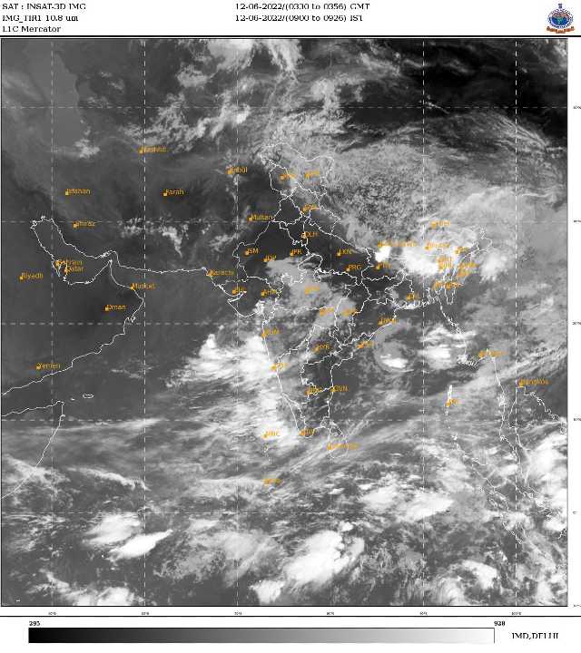 In Satellite Imagery: Excessive Clouding over West Coast of India due to strengthening of Offshore Trough[/caption] The Strengthening of Westerly winds in the Arabian sea will lead to major rains across Goa, the West coast and Ghats of Karnataka and Kerala throughout this week. The region is likely to experience Widespread on and off moderate to heavy rains and very heavy in patches typical of monsoon season. The rains will certainly decrease in the interiors of Karnataka and Tamil Nadu. Only light to moderate rains are expected in isolated places during the evening hours over this week. Expected rainfall accumulation in stations of South India till 18 June: Goa – 200mm Karnataka – 150mm Kerala – 100mm Andhra Pradesh – 60mm Telangana – 55mm Tamil Nadu – 30mm The author, better known as the Rohtak Weatherman, interprets and explains complex weather patterns. His impact-based forecasts @navdeepdahiya55 are very popular in north India. Read all the Latest News , Trending News ,
Cricket News , Bollywood News , India News and Entertainment News here. Follow us on
Facebook,
Twitter and
Instagram.

 "The Weather Report: Monsoon hits Goa, coastal Maharashtra; north India reels under heat wave")

 "Russian drones over Poland: Trump’s tepid reaction a wake-up call for Nato?")
 "As Russia pushes east, Ukraine faces mounting pressure to defend its heartland")
 "Why Mossad was not on board with Israel’s strike on Hamas in Qatar")
 "Turkey: Erdogan's police arrest opposition mayor Hasan Mutlu, dozens officials in corruption probe")


](https://images.firstpost.com/wp-content/uploads/2022/06/onset_SW-1.jpg)
](https://images.firstpost.com/wp-content/uploads/2022/06/Satellite-12-06-2022.jpg)