
 "The Weather Report: Heavy rains expected in Chhattisgarh, Maharashtra, Gujarat this week")
The past week marks the start of August and the month remains very crucial for India historically as well as for the agriculture sector. In the past, we’ve seen flooding in some parts of India and droughts in other regions in August. August always had the highest rainfall variations despite being the wettest month of the year. “Deluge here and drought there” is the right term to use for the monsoon rains in the month of August. Over the past week, the rainfall performance in India has been pretty constant with rains focusing on the targeted areas with floods which have been Kerala and Karnataka in this case. The massive westerly surge which is also known as an offshore trough resulted in extreme rainfall in many parts of Kerala and Coastal Karnataka across the past week. Coastal Karnataka was lashed by extreme rains on 2 August, Uttara Kannada district experienced rainfall in the range of 250-550mm in a very short time period, technically falling in the cloudburst category. Muttalli – 533.5mm Mundalli – 521.5mm Susgadi – 517.5mm Mavinkurve – 491.0mm Koppa – 483.5mm Shirali – 288.0 mm The high-intensity rains continue to impact various parts of the coast, Ghat sections of Kerala and Karnataka till the weekend. Stations in Kabini catchments areas in the Wayanad continue to record heavy showers till 8:30 AM on 6 August: Thariode – 217mm Vythiri – 200mm Kalpeta – 170mm Kuppady – 106mm Mananthavady – 95mm Meenangadi – 90mm Amabalavayal – 85mm Strong Westerlies and convergence is so strong that it pounded Nilgiris in Tamil Nadu with heavy rains ending 8.30 AM on 6 August: Avalanche – 200mm Chinnakallar – 194mm Devala – 181mm Naduvattam – 152mm Upperbhavanni – 140mm Sholayar – 132mm Pandalur – 110mm Valparai PAP – 107mm Similarly in the hills of North India, heavy rainfall events were observed in the past week especially over parts of Uttarakhand which resulted in landslides, cloudbursts and travel delays at the hill stations. Uttarakhand had very heavy rains in the period of 24 hours on 3 August: Karanpur – 194mm Loharkhet – 189mm Saung – 167mm Sahastradhara – 137mm Banbasa – 132mm Chorgalia – 127mm Tanakpur – 119mm Khatima – 117mm Rikhnikhal – 108mm Munsiyari – 107mm Bangapani – 94mm Haldwani – 89mm Narendranagar – 85mm On 4 August, intense rains within a short span of time in parts of Uttarakhand and Himachal Pradesh caused damage to life and property. Bhagwanpur – 186mm Haripur – 142mm Sahastradhara – 115mm Kalsi – 110mm Uttarkashi – 109mm Ucost – 106mm Barkot – 103mm Sirmaur – 162mm Kasauli – 110mm As the monsoon rains continue to pound the southern peninsula and Himalayas, there are hardly any significant rains in the East and North East of the country. There is also a slowdown of rains in Central India balancing the overall rainfall growth in India which has remained flat in the past week. [caption id=“attachment_11023911” align=“alignnone” width=“640”] 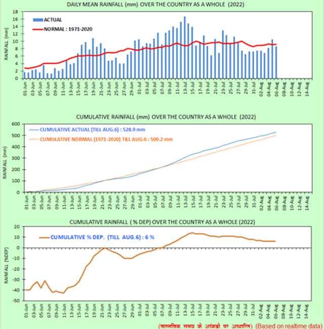 Flat curve of cumulative rainfall % departure on pan India level[/caption] As per IMD data, total monsoon seasonal rains in India from 1 June till 6 August: • India as a whole recorded a total of 528.9mm rainfall against the average of 500.2mm, a departure from normal Stands at +6 per cent, it was at +8 per cent past Saturday. Subdivision-wise seasonal rainfall figures: • Southern Peninsula: Actual 552.0mm against the average of 405.8mm, +36 per cent departure from normal. • East & North East India: Actual 694.6mm against the average of 815.5mm, -15 per cent departure from normal. • North West India: Actual 335.0mm against the average of 330.2mm, +1 per cent departure from normal. • Central India: Actual 614.0mm against the average of 561.3mm, +9 per cent departure from normal. [caption id=“attachment_11024121” align=“alignnone” width=“640”] 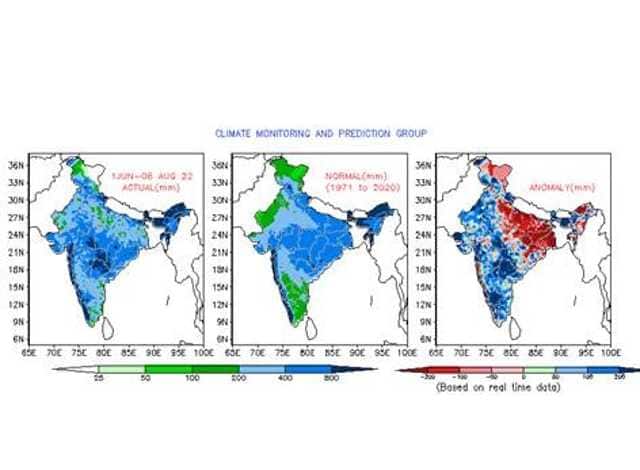 Pan India seasonal spatial rainfall distribution, positive rainfall anomaly in south,west and central India while highly negative in North East and East India[/caption] Current Synoptic features affecting weather in India on 6 August: • The monsoon trough at mean sea level continues to pass through Jaisalmer, Kota, Sagar, Pendra Road, Balasore and thence south eastwards to East central Bay of Bengal. • The cyclonic circulation over northwest Bay of Bengal and neighbourhood extending upto 5.8 km above mean sea level tilting southwestwards with height persists. Under its influence, a Low Pressure Area is likely to form over the same region during the next 24 hours. It is likely to become more marked during subsequent 24 hours. • The off-shore trough at mean sea level from south Maharashtra coast to north Kerala coast persists. • The cyclonic circulation over east central and adjoining northeast Arabian Sea between 3.1 km & 5.8 km above mean sea level persists. • The Western Disturbance as a cyclonic circulation over central Pakistan & neighbourhood at 3.1 km above mean sea level with trough aloft with its axis at 5.8 km above mean sea level in middle tropospheric westerlies roughly along Long.68°E to the north of Lat.30°N persists. • The cyclonic circulation over central parts of Rajasthan & neighbourhood at 1.5 km above mean sea level persists. All India weather forecast till 13 August: North India: The current synoptic features indicate that the monsoon axis will remain south of its normal position for many days in the upcoming week. During such cases the monsoon rains slow down over North India and the same is expected for the next week till 13 August. Easterlies on the lower levels may ensure partly cloudy skies along with scattered light to moderate rains in Uttar Pradesh, Delhi NCR, Haryana, Punjab, Rajasthan and hilly states but overall there will be reduction in heavy rainfall events except south Rajasthan where heavy rains might continue as the trough continues to pass. In presence of moist easterlies and patchy rains weather will become highly humid with high real feel conditions are expected to make a comeback. Expected precipitation accumulation till 13 August: • Rajasthan – 110mm • Uttarakhand – 80mm • Himachal Pradesh – 70mm • Delhi NCR – 50mm • Uttar Pradesh – 40mm • Haryana – 40mm • Punjab – 30mm • Jammu and Kashmir – 30mm Central India A significant reduction in rains were observed in most parts of Central India during the past week in absence of any typical monsoonal phenomenon - only scattered light to moderate rains were experienced in Chhattisgarh, Madhya Pradesh and Gujarat. Rains have started increasing in parts of Maharashtra and Mumbai weekend onwards. Now the formation of Low Pressure Area in the Bay of Bengal by Sunday will play a very crucial role in enhancing rains across the central country parts in the next week. [caption id=“attachment_11024251” align=“alignnone” width=“640”] 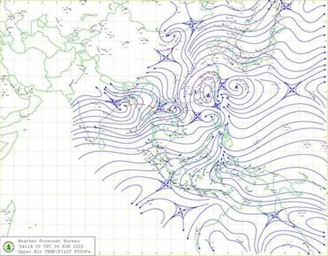 Cyclonic circulation over Bay of bengal next to east coast of India is expected to develop into a low pressure area in the next 24 hours and then deepen into depression by Monday[/caption] A Low-Pressure Area will form in the Bay of Bengal by Sunday and gradually deepen into a depression by early next week and move across Odisha, Chhattisgarh, Madhya Pradesh, Maharashtra and Gujarat in the next week. States are expected to experience widespread heavy to very heavy rains during 7 to 11 August. Flooding may occur in some parts of South Chhattisgarh, Maharashtra and South Gujarat due to unprecedented rains. Expected precipitation accumulation till 13 August • Maharashtra – 240mm • Chhattisgarh – 150mm • Gujarat – 120mm • Madhya Pradesh – 110mm East and North East India The current status of rainfall deficiency in Jharkhand stands at -48 per cent below normal, -46 per cent in West Bengal whereas -33 per cent in Bihar. As the depression is anticipated to move across Central India it will keep the monsoon axis shifted south of its normal position due to which rains will remain on a lesser side across the East and North East India except Odisha which will be directly impacted by the movement of the depression. [caption id=“attachment_10394181” align=“alignnone” width=“640”]  Weather symbols. Image courtesy Peepo/Wikimedia Commons [/caption] Over the upcoming week Odisha will experience widespread moderate to heavy rains with isolated very heavy rains but only isolated light to moderate rains will be observed in West Bengal, Jharkhand, Bihar, Sikkim, Arunachal Pradesh, Assam, Meghalaya, Mizoram, Nagaland, Tripura and Manipur. Rains will remain below normal and anomalies will turn further negative as the region remains drought hit. Expected precipitation accumulation till 13 August: • Odisha – 130mm • North East India – 70mm • West Bengal – 50mm • Jharkhand – 40mm • Bihar – 20mm South India The formation of depression in the Bay of Bengal will keep parts of the southern peninsula active in terms of monsoonal activities. As the depression will move across Central India next week, it will bring heavy to very heavy rain to most parts of Andhra Pradesh and Telangana from 7 to 10 August. Due to the pull effect, the offshore trough will remain aggressive across the west coast of India, Moderate to heavy rains will be observed in most parts of the coastal areas in Goa, Karnataka and Kerala across this week. As the coastal rains increase the leeward side will see a significant reduction in rains over the next week. Most parts of south Andhra Pradesh, Tamil Nadu and southern interiors of Karnataka will experience dry weather with only isolated rains in the evening hours. Following the trend of the last few weeks, the southern peninsula region will experience above-normal rains in the upcoming week. Expected precipitation accumulation till 6 August: • Goa – 150mm • Telangana – 130mm • Karnataka – 130mm • Kerala – 100mm • Andhra Pradesh – 90mm • Tamil Nadu – 30mm The author, better known as the Rohtak Weatherman, interprets and explains complex weather patterns. His impact-based forecasts @navdeepdahiya55 are very popular in north India. Read all the Latest News , Trending News , Cricket News , Bollywood News , India News and Entertainment News here. Follow us on Facebook, Twitter and Instagram.
The Weather Report: Flooding may occur in some parts of South Chhattisgarh, Maharashtra and South Gujarat due to unprecedented rains
Advertisement
End of Article

 "Russian drones over Poland: Trump’s tepid reaction a wake-up call for Nato?")
 "As Russia pushes east, Ukraine faces mounting pressure to defend its heartland")
 "Why Mossad was not on board with Israel’s strike on Hamas in Qatar")
 "Turkey: Erdogan's police arrest opposition mayor Hasan Mutlu, dozens officials in corruption probe")


](https://images.firstpost.com/wp-content/uploads/2022/08/W1.jpg)
](https://images.firstpost.com/wp-content/uploads/2022/08/W2.jpg)
](https://images.firstpost.com/wp-content/uploads/2022/08/W3.jpg)
](https://images.firstpost.com/wp-content/uploads/2022/02/Weather_Icons640.jpg)