 "‘Make in India’ Rafales: MoD begins review of Rs 2 lakh crore fighter jet proposal")
 "Nari Shakti sets sail: 10 women officers from 3 forces on historic voyage around the world")
Cyclone Vayu in Gujarat LATEST updates: Skymet Weather has predicted that after Gujarat, Pakistan will, too, escape the fury of Cyclone Vayu which is presently over northeast and adjoining east-central Arabian Sea. Talaja taluka in Bhavnagar received the highest amount of rainfall in the state with 41 mm, while Jafrabad and Khambha in Amreli district received the second highest rainfall in the state with 35 mm. IMD said that Cyclone Vayu is now moving northwestwards and has started skirting Saurashtra coast. It further said that heavy spells of rainfall are continuing over coastal areas and are likely to go on for the next three hours. Mumbai witnessed Strong winds and rainfall as Cyclone Vayu moved northwestward from the Gujarat coast. State Revenue Minister Kaushik Patel said that Prime Minister Narendra Modi and Union Home Minister Amit Shah are in constant touch with Vijay Rupani, Gujarat Chief Minister. He also mentioned that a few senior ministers have gone to the districts to coordinate and review the situation. Iqbal Singh Chauhan, DIG of Coast Guard, Porbandar, addressing media persons, said it would be Saturday before the cyclone completely crosses over into the sea at Dwaraka. “The next few hours will be very important for Gujarat. To all our fishermen and coastal residents, we request you to move to safer places,” Chauhan said. Storm Surge of the height of 1.5 - 2.0 metres above the astronomical tides is likely to inundate the low lying coastal areas of Devbhoomi Dwarka, Porbandar, Junagarh, Diu, and Gir Somnath districts in the afternoon. “Even though Cyclone Vayu is not hitting Gujarat there is still a danger of destruction. We are expecting winds to hit speeds of 100 to 135 kilometres per hour. The NDRF and coast guard have evacuated many areas along the coastline as a precaution,” Jayant Sarkar IMD Ahmedabad told News18 Manorama Mohanty, scientist at India Meteorological Department (IMD), Ahmedabad said that Cyclone Vayu won’t hit Gujarat now as it has changed course overnight. It will skirt through coast of Veraval, Porbandar and Dwarka. Its effect will be seen on the coastal regions as there will be heavy wind speed and heavy rain as well. Air passengers to and from the megapolis had a tough time Wednesday as nearly 400 flights were affected due to bad weather caused by the cycle Vayu which hit the neighbouring Gujarat coast, according to an airport official. Cyclone Vayu appears to have changed course overnight. According to the IMD, it moved north-northwestwards in the last six hours and is currently 130 km southwest of Veraval in Gujarat and 180 km south of Porbandar. It is likely to move north-northwestwards for some time and then northwestwards, skirting the coast of Saurashtra with wind speeds of 135 kmph to 145 kmph from Thursday afternoon. On Thursday, an alert was sounded in 10 districts of Gujarat as Cyclone Vayu has turned “very severe” and its impact is expected to remain strong for 24 hours even after its landfall, officials said. As many as 52 teams of the National Disaster Management Relief Force, comprising around 45 rescuers each, have been moved to the state, while 10 columns of the Indian Army have been kept on stand-by. Warships and aircraft of the Indian Navy have been kept standby as well. A general alert has been sounded across 10 districts in Gujarat as wind speeds are likely to touch 170 kilometres per hour, a home ministry official said. Vayu has turned into a “very severe” cyclone and it is expected that its impact will continue to be strong for 24 hours even after the landfall between Porbandar and Union Territory Diu, the official said. Normally a cyclone becomes weak after its landfall. Residents of some of the Gujarat districts have been asked to move out to safer places or cyclone shelters. Meanwhile, home secretary Rajiv Gauba on Wednesday chaired a meeting of the National Crisis Management Committee where preparation for relief and rescue operations were discussed threadbare. The meeting took stock of the precautionary measures taken by the Gujarat government and Diu Union Territory administration to ensure that no human life is lost, damage to vital infrastructure is minimised and to ensure early recovery of all essential services post-cyclone landfall. Diving and rescue teams and relief materials have been kept on standby for rendering assistance to civil authorities, as required, another official said. Medical teams and facilities at Indian Naval hospital in Mumbai are on standby to handle medical emergencies. Both the administrations have also been advised for timely evacuation of people from low-lying coastal and vulnerable areas. The Gujarat and Diu administration are evacuating about three lakh people from the identified vulnerable areas and they are being shifted to around 700 cyclone and relief shelters. With inputs from PTI
Cyclone Vayu in Gujarat updates: As storm skirts Saurashtra coast, Skymet Weather predicts Pakistan to also escape cyclone's fury
Cyclone Vayu in Gujarat LIVE updates: Skymet Weather has predicted that after Gujarat, Pakistan will, too, escape the fury of Cyclone Vayu which is presently over northeast and adjoining east-central Arabian Sea.
)
Fully prepared for the cyclone, says DIG of Coast Guard, Porbandar
Skymet Weather predicts Pakistan to also escape cyclone’s fury
Skymet Weather has predicted that after Gujarat, Pakistan will, too, escape the fury of Cyclone Vayu which is presently over northeast and adjoining east-central Arabian Sea.
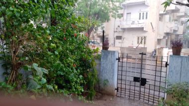
Heavy rains in Ahmedabad
Areas like Sola Bhagwat, Ambavadi and Memnagar received heavy rainfall and strong winds. The rains will continue in the state, according to the forecast by the state meterological department earlier on Thursday.
By Binita Parekh/101Reporters
Gujarat BJP chief visits vulnerable areas in Gir Somnath
State BJP president Jitu Vaghani visited various areas of Gir Somnath district which are likely to be affected due to Cyclone Vayu.
By Masuma Jariwala/101Reporters
Rainfall data from 6 am to 4 pm in Gujarat
Talaja taluka in Bhavnagar received the highest amount of rainfall in the state with 41 mm, while Jafrabad and Khambha in Amreli district received the second highest rainfall in the state with 35 mm.
By Amit Cowper/101Reporters
123 train services under Western Railway affected due to Cyclone Vayu
As per data from the Public Relations Officer, Rajkot, a total of 123 trains under the Western Railway have been affected. 86 trains have been cancelled while 37 trains were short-terminated.
By Masuma Jariwala/101Reporters
Over one inch rainfall recorded in nine Gujarat talukas
A significant amount of rainfall was received by 20 talukas as an effect of Cyclone Vayu. According to the information received from the State Emergency Operation Centre, rains of over one inch was recorded in Jafrabad, Khambhat, Talaja, Lathi, Mahuva, Rajula, Palitana, Amreli, Gadhda.
Moreover, rainfall of more than half an inch was registered in 11 talukas including Gariyadhar, Savarkundla, Vallabhipur, Jesar, Kalyanpur, Babra, Choryasi and Jalalpor.
Amit Cowper/101Reporters
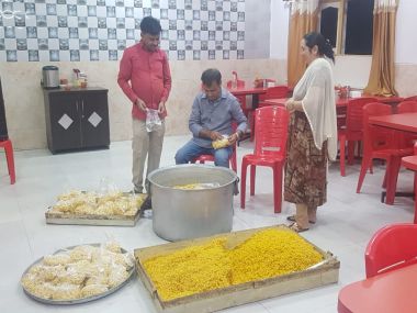
3,000 food packets prepared by group volunteers in Mangrol
Volunteers of Rajpa Chudasama and Mama Sarkar group prepared 3,000 food packets for distribution to the affected areas, in Mangrol taluka in Junagadh district.
By Darshana Jamindar/101Reporters
31 trains under Rajkot WR division cancelled, 22 short-terminated
A total of 31 trains were cancelled while 22 were short-terminated in the wake of Cyclone Vayu, according to a release from the Rajkot division of Western Railway.
By Masuma Jariwala/101Reporters
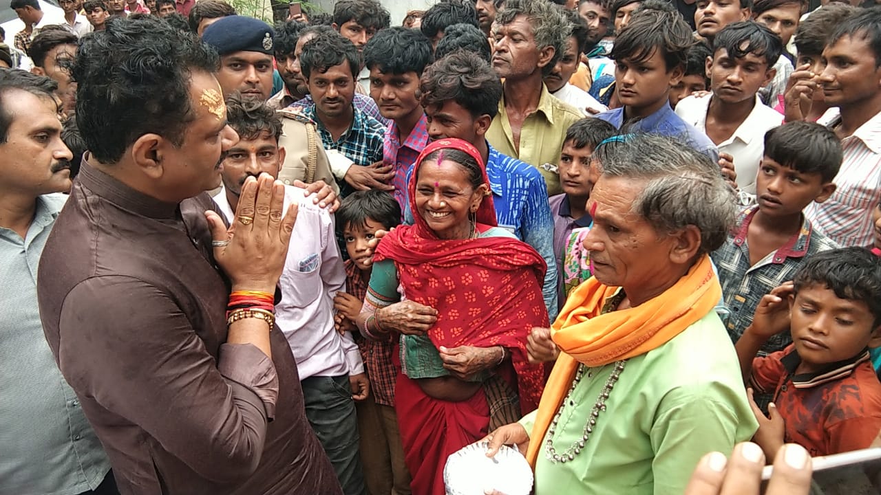
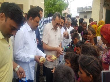
Gujarat minister takes stock of situation in Gondal
Gujarat energy minister Saurabh Patel took stock of the situation at Gondal city in Rajkot district and personally distributing food packets.
Input by Masuma Jariwala/101Reporters
Cyclone Vayu moving northwestwards, has started skirting Saurashtra coast: IMD
IMD said that Cyclone Vayu is now moving northwestwards and has started skirting Saurashtra coast. It further said that heavy spells of rainfall are continuing over coastal areas and are likely to go on for the next three hours.
NDRF rescues pregnant woman requiring pre-term delivery in Gujarat
NDRF rescued a pregnant woman requiring pre-term delivery from Shiyalbet village, where boats are the only mode of transportation, and brought her to a hospital in Jafarabad. ANI reported that the woman successfully delivered a baby boy and condition of both the child and mother is stable.
How a cyclone is formed?
NASA explains the formation of a tropical cyclone in the following way: Tropical cyclones are like giant engines that use warm, moist air as fuel. That is why they form only over warm ocean waters near the equator. The warm, moist air over the ocean rises upward from near the surface. Because this air moves up and away from the surface, there is less air left near the surface.
Air from surrounding areas with higher air pressure pushes in to the low pressure area. Then that “new” air becomes warm and moist and rises, too. As the warm air continues to rise, the surrounding air swirls in to take its place. As the warmed, moist air rises and cools off, the water in the air forms clouds. The whole system of clouds and wind spins and grows, fed by the ocean’s heat and water evaporating from the surface. As the storm system rotates faster and faster, an eye forms in the center.

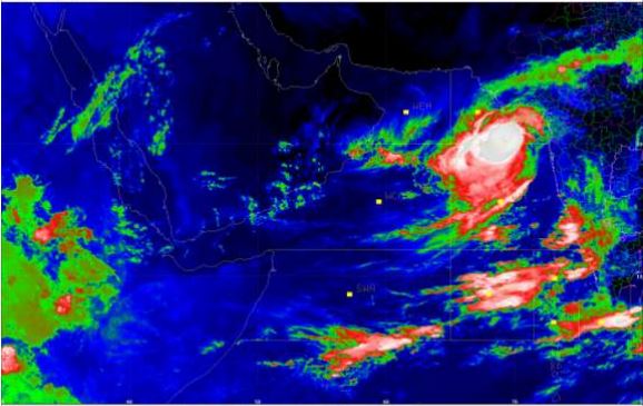
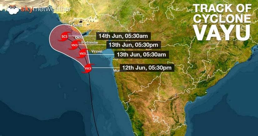
Cyclone Vayu likely to move north-northwest
According to a release by the India Meteorological Department, Ahmedabad, Very Severe Cyclonic Storm, Vayu is 160 km south-southwest of Diu, 110 km southwest of Veraval (Gujarat) and 140 km south of Porbandar (Gujarat).
It is very likely to move north-northwest for some time and then north-west skirting the Saurashtra coast affecting Gir Somnath, Diu, Junagarh, Porbandar and Devbhoomi Dwarka with wind speed 135-145 kmph gusting to 160 kmph.
Red alert for heavy rains, damaging winds despite Cyclone Vayu missing Gujarat
Cyclone Vayu will not make landfall but would now just skirt the Gujarat coast. However, as the system is sustaining strength of category 2 typhoon, Gujarat continues to be under red alert.
According to SkymetWeather , Gujarat might have escaped the Cyclone Vayu fury but it remains susceptible to heavy to very heavy rains along with high speed winds. Areas such as Amreli, Gir Somnath, Diu, Junagarh, Porbandar, Rajkot, Jamnagar, and Dwarka would see widespread rainfall with heavy to very heavy rains. Few places might also see extremely heavy rains today leading to inundation in low lying areas.
Cyclone Vayu to completely abate by Saturday, says Indian Coast Guard
Iqbal Singh Chauhan, DIG of Coast Guard, Porbandar, addressing media persons, said it would be Saturday before the cyclone completely crosses over into the sea at Dwaraka.
“The next 50-60 hours will be very important for Gujarat. To all our fishermen and coastal residents, we request you to move to safer places. If you live in kachha house, please go to the relief camps set up by the state government because the wind speeds are going to very high and the sea is expected to surge to about 1-1.5 metres. I want to inform all the citizens of India that the pre-emptive steps taken by the administration, government agencies and armed forces will ensure that there is no loss of life.”
Input by Masuma Jariwala/101Reporters
AAI says no damage so far to airport infrastructure in Gujarat
The impact of cyclone Vayu has been milder at most airports in Gujarat and there has been no damage to aerodromes’ infrastructure so far, Airports Authority of India (AAI) said Thursday. To avoid disruptions and damages to infrastructure, the AAI has suspended flight operations at airports in Porbandar, Diu, Bhavnagar, Keshod and Kandla for 24 hours starting midnight Wednesday. Citing updates given by airport directors, the AAI said effect of the cyclone has been milder at most of the airports of Gujarat.
PTI
NDRF team rescues and shifts a pregnant woman from Cyclone Vayu-hit area
A team of Indian Coastguard and NDRF successfully resqued a woman who was in the last trimester of her pregnancy and went into premature labour at Siyalbet (an island off Rajula coast in Gujarat’s Amreli district) medical center. The joint team brought the woman to the mainland where a team of doctors took her to a centre with NICU (Neonatal Intensive Care unit) facilities, News18 reported.
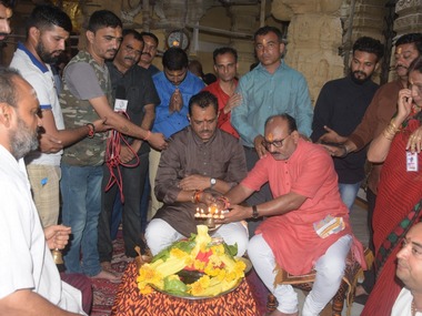
Gujarat BJP chief Jitu Vaghani prayed at Somnath temple for people’s safety
BJP state president, Jitu Vaghani was at Somnath Temple earlier today to pray for the safety of people in the wake of Cyclone Vayu. It is noteworthy here that the IMD had issued severe warnings for the Gir Somnath district advising people not to venture out. However, the temple remained open even as a few sheds within the premises were blown away by winds, ANI reported. Gujarat minister Bhupendrasinh Chudasama said that pooja can’t be stopped as it has been going on since many years.
Image by Masuma Jariwala/101Reporters
IMD’s latest bulletin says Cyclone Vayu practically stationary in past few hours, likely to head northwestwards
The latest bulletin of the Indian Meteorological Department said that the storm has practically been stationary near Lat 20.5 degree North. and Long 69.4 degree East.
Amit Shah, Narendra Modi in constant touch with Gujarat CM over cyclone preparedness
State Revenue Minister Kaushik Patel addressed the media at the State Emergency Operation Centre. He said that Prime Minister Narendra Modi and Union Home Minister Amit Shah are in constant touch with Gujarat chief minister Vijay Rupani. He also mentioned that a few senior ministers have gone to the affected districts to coordinate and review the situation.
Input by Amit Cowper/101Reporters
Citizens advised to remain in shelters even as IMD says cyclone may not hit coast
Pankaj Kumar, Additional Chief Secretary of Gujarat’s Revenue Department says that the state will continue to be on high alert despite the storm shifting its course. “Persons shifted to shelter homes will stay there and others should continue to stay in safe areas. Preparedness is to continue at the same level.”
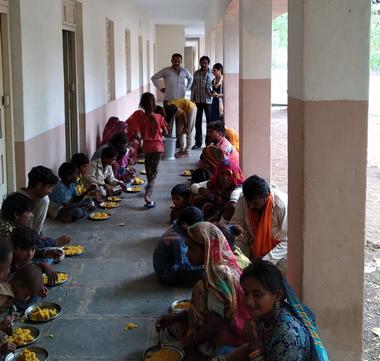
In this image, district administration personnel are seen serving meals at a shelter home in Moti Marad village of Dhoraji Taluka in Rajkot district.
Image by Masuma Jariwala/101Reporters
High wind speed of up to 50-60 kmph gusting to 70 kmph likely over north Maharashtra Coast
National Disaster Management Authority of India (NDMA) has tweeted saying, “Gale winds speed of the order of 135-145 kmph gusting to 160 kmph very likely to prevail over the north Arabian Sea and Gujarat coast. It is very likely to be 50-60 kmph gusting to 70 kmph over north Maharashtra Coast and northern parts of east-central Arabian Sea.”
Gujarat Revenue Secretary says heavy rainfall expected in parts of state
Addressing a press conference at the SEOC, ACS (Revenue) Pankaj Kumar maintained that according to the bulletin by the state Meteorological Department, Cyclone Vayu is 110 kilometres from Veraval to the south-west and 150 kilometres from Porbandar to the south. The cyclone is moving towards the north and is likely to cross Saurashtra in the afternoon. Cyclone Vayu is predicted to have a wind speed of 135 to 145 kilometres per hour. The weather forecast predicts that several parts of the state will receive very heavy rainfall.
Amit Cowper/101Reporters
Cyclone Vayu to dissolve before reaching Karachi coast, says Skymetweather
After it skirts the Gujarat coast , Vayu is likely to encounter an anti-cyclone over North Arabian Sea which will result its stagnation near the Karachi Coast. There is also a likelihood of Vayu making no landfall and weakening in the sea itself, Skymetweather reported.
HAM Radio channels in service to aide communication in Gujarat
HAM radio channels kick into service to aide in public communication. Gandhinagar High Frequency (HF) is on the air, Rajkot-Gandhinagar having 5/9 communication (5/9 means loud and clear) in also active. Rajkot Amateur Club Station is also on air. Currently, three Ham stations are active in Gandhinagar, Rajkot and Veraval. These radio channels prove to be a useful channel of communication when poer is down and other channels are compromised due to a natural calamity.
Input by Masuma Jariwala/101Reporters
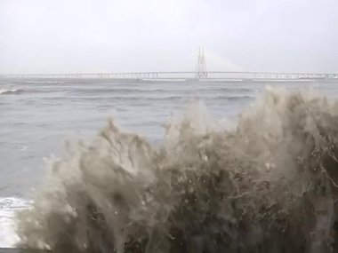
Mumbai, coastal Maharashtra districts get relief from heat due to Cyclone Vayu
While heading towards Gujarat earlier, the cyclonic storm had brought some good spell of rain to Mumbai and neighbouring Raigad, Thane and Palghar districts of Maharashtra, News18 reported. The mega city, earlier reeling under an intense spell of humid heat, saw a drop in temperatures since Tuesday night as the deep depression over Arabian Sea intensified into a cyclonic storm and neared the coast, bringing pre-monsoon showers.
Cyclone Vayu may weaken into Category 1 storm but squally winds may still cause damage: Skymetweather
The system would continue to travel in water but the proximity of coast might lead to its weakening. Very severe Cyclone Vayu which at present is Category 2 storm may weaken into a Category 1 storm. However, the system would be packed with the winds to the tune of 135 kmph to 145 kmph gusting up to 175 kmph may cause damage.
As per weatherman, the reason behind the change in the track is that Vayu would encounter with weak steering environment.
Eye of storm will not enter Gujarat
Speaking to reporters in Ahmedabad, the meteorological department’s Additional Director Manorama Mohanti said the direction has “slightly” changed. “The ‘very severe’ cyclonic storm Vayu will not make landfall on the Saurashtra coast, but it will skirt the coast and affect Gir-Somnath, Junagadh, Porbandar, Devbhoomi-Dwarka districts and Union Territory Diu,” she said. “The eye of the storm will not enter Gujarat, but half of the storm, the outer peripheral part, will enter the state and affect the coastal areas,” Mohanti said.
IMD warns of power outage, gale winds, very rough sea conditions even as Vayu to brush past Gujarat Coast
According to The Weather Channel , Cyclone Vayu’s possible impact could be:
- > 70 mm rain in southwest Gujarat over the next 48 hours
- > Gale winds of 100 kmph expected along southwest coast of Gujarat
- > Up to 9 metre-high waves off Veraval today
- > Flash flooding, storm surge, downed trees, power outages and damage to buildings may be expected
IMD warns cyclone can cause substantial damage even without hitting ground
“Even though Cyclone Vayu is not hitting Gujarat there is still a danger of destruction. We are expecting winds to hit speeds of 100 to 135 kilometres per hour. The NDRF and coast guard have evacuated many areas along the coastline as a precaution,” Jayant Sarkar IMD Ahmedabad told News18.
The weather department’s bulletin later clarified: Total destruction of thatched houses/extensive damage to Kutcha houses. Some damage to pucca houses. Potential threat from flying objects.(ii) Bending/uprooting of power and communication poles. (iii) Major damage to Kutcha and Pucca roads. Flooding of escape routes. Minor disruption of railways, overhead power lines and signalling systems.
(iv) Widespread damage to standing crops, plantation, orchards, falling of green coconuts and
tearing of palm fronds. Blowing down bushy trees like mango.(v) Small boats, country crafts
may get detached from moorings, can be expected.
Gujarat coastal areas to experience winds up to 160kmph
According to the Gujarat Information Department, the Very Severe Cyclonic Storm VAYU lies near latitude 20.0°N and longitude 69.6°E over East Central and adjoining Northeast Arabian Sea, 130 kilometre southwest of Veraval (Gujarat) and 180 km nearly south of Porbandar (Gujarat).
It is very likely to move North-Northwestwards for some time and then Northwestwards skirting the Saurashtra coast affecting Gir Somnath, Diu, Junagarh, Porbandar and Dev Bhoomi Dwarka with wind speed 135-145 kmph gusting to 160 kmph from afternoon of 13th June 2019.
Input by Amit Cowper/101Reporters
IMD says Cyclone Vayu to affect Gir Somnath, Diu, Porbandar, Dwarka
The very severe cyclonic storm “vayu” is very likely to move north-northeastwards for some time and then northwstwards skirting the saurashtra coast affecting Gir Somnath, Diu, Junagarh, Porbandar and Devbhoomi Dwarka with wind speed 135-145 kmph gusting to 160 kmph from afternoon of 13 June 2019.
Cyclone Vayu may weaken into Category 1 storm after skirting Gujarat coast, but high wind speeds still likely in coastal areas
Cyclone Vayu is likely to weaken after skirting the Gujarat coast near Porbandar. The weakening would take place due to its proximity of the coast as it is likely to become a Category 1 storm. However, winds to the tune of 135 kmph to 145 kmph gusting up to 175 kmph may cause damage over the Gujarat coast.
As per Skymetweather, Vayu may encounter weak steering environment, due to which the system could change its track. As the system curves north-northwest, Vayu’s speed will also become slow.
Weather scientist says Cyclone Vayu won’t hit Gujarat but is likely to cause heavy rainfall, gusty winds in coastal districts
Manorama Mohanty, scientist at India Meteorological Department (IMD), Ahmedabad said that Cyclone Vayu won’t hit Gujarat now as it has changed course overnight. It will skirt through coast of Veraval, Porbandar and Dwarka. Its effect will be seen on the coastal regions as there will be heavy wind speed and heavy rain as well.
Flight operations to be suspended in Porbandar, Diu, Bhavnagar, Keshod, Kandla till midnight today
The Airports Authority of India said flight operations at airports in Porbandar, Diu, Bhavnagar, Keshod, Kandla will be suspended for 24 hours from midnight in view of Cyclone Vayu.
Somnath temple open to worshippers despite severe weather warnings, Gujarat minister says can’t stop puja
The Somnath Temple remained open despite alert issued in view of Cyclone Vayu today. According to ANI several devotees turned up at the temple even as the sheds in the temple premises were blown away by high speed winds.
But reacting to the news, Gujarat minister Bhupendrasinh Chudasama told _ANI, “_Temples can’t be closed. We have requested tourists not to visit, but aarti is being performed since many years. It can’t be stopped.
400 Mumbai flights affected due to Cyclone Vayu
Air passengers to and from the megapolis had a tough time Wednesday as nearly 400 flights were affected due to bad weather caused by the cycle Vayu which hit the neighbouring Gujarat coast, according to an airport official.
The city airport is one of the busiest in the country handling over 900 aircraft movements daily. The official said as many as 194 departing flights and 192 arrivals were delayed in the wake of the bad weather due to the cyclone Vayu. At least two flights were diverted from the city, the official said.
Citizen groups take up charge to prepare for impending storm, distribute food packets in affected area
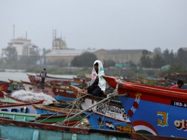
All Maharashtra beaches in Konkan region shut off to public
In view of the Cyclone Vayu, which is traversing fast in the Arabian Sea coupled with high tide on 12 and 13 June, all beaches in Konkan region have been shut off to the public.