Cyclone DAYE Latest updates: Cyclone Daye crossed Odisha state and has moved towards Chattishgarh state. According to the latest IMD report, it was centred roughly east-southeast of Raipur. It is very likely to continue to move west-northwestwards and weaken gradually into a Depression during next 12 hours. Cyclone DAYE, which made landfall in Odisha at midnight, has since weakened and will become a Tropical Depression by Friday afternoon. The Tropical Cyclone (now downgraded to a deep depression) will cause heavy rain, thunderstorm and gusty winds around northeastern, eastern, central and western India on Friday. In Odisha, water level has increased in Kolab dam which lead to two gates being opened. Meanwhile, a flood-like situation in parts of Baleswar district, following heavy downpour, has thrown normal life out of gear. The Kankarkonda, Korkonda, Poteru and MV 37 rivers have swollen and are flowing above the red mark following heavy rainfall in Malkangiri district. The water level has increased in Balimela water reservoir in Chitrakonda area of the district. After crossing the Odisha coast, Cyclone DAYE will head in a classical west-north-west direction (diagonal across Central and Western India) over the weekend and early next week. The cyclonic depression having peaked into a full-fledged storm early on Friday will have gusty wind speeds of up to 70 to 80 km/hr and it would continue to move west-north-west over land after crossing the Odisha coast, and weaken back into a deep depression on Friday next week. In Odisha, the district administrations of Puri and Ganjam have been asked to carry out evacuation in vulnerable and low-lying areas in their respective regions, if necessary. All concerned departments have been put on alert and the situation is being closely monitored. Cyclonic storm ‘DAYE’ crossed the coast near Gopalpur in Odisha early Friday, triggering heavy downpour accompanied by high velocity wind in several parts of the state. The India Meteorological Department (IMD) had issued a warning on Thursday for south Odisha and coastal Andhra Pradesh. In an official release at 6 pm, the IMD said there is a deep depression over west central Bay of Bengal which was likely to intensify into a cyclonic storm with wind speed of 60-70 kmph in next 12 hours. The IMD said the deep depression lay centred over west central Bay of Bengal about 290 km east-southeast of Kalingapatnam (Coastal Andhra Pradesh) and about 270 km southeast of Gopalpur (Odisha). “It is likely to intensify into a cyclonic storm during next 12 hours. It is very likely to move west-northwestwards and cross south Odisha, north Andhra Pradesh coasts between Kalingapatnam and Puri (Odisha), close to Gopalpur around mid-night of Thursday as a cyclonic storm with wind speed of 60-70 kmph gusting to 80 kmph,” it said. Meanwhile, Odisha chief minister Naveen Patnaik asked officials of the coastal districts to be alert and prepared. Patnaik issued direction for cancelling holiday in government offices in Ganjam, Gajapati, Puri, Nayagarh and Khurda districts, which are likely to be hit by fierce winds.
Cyclone in Odisha 'Daye' updates: Cyclonic storm continues westward movement, reaches Chhattisgarh; may weaken by evening
Cyclone Daye LIVE updates:Cyclone Daye crossed Odisha state and has moved towards Chattishgarh state. According to the latest IMD report, it was centred roughly east-southeast of Raipur. It is very likely to continue to move west-northwestwards and weaken gradually into a Depression during next 12 hours.
)
Two shutters of Upper Kolab dam opened due to heavy rainfall
Heavy rainfall recorded in Malkangiri district
Heavy rainfall was recorded in Malkangiri district in last 24 hours. The highest rainfall was recorded in Korukonda area which received 403 mm rainfall; Malkangiri received 265.4 mm rainfall, Kalimela got 118 mm rainfall, Mathili received 103 mm rainfall, Khairiput got 83 mm rainfall and K Guma recieved 135 mm rainfall.
Input by Subrat Kumar Pati/101Reporters
Visuals from Potaru area in Malkangiri
IMD says deep depression likely to move westwards, may weaken by evening
Deep depression over south Odisha and neighbourhood moved further west-northwestwards during past six hours and lay centred at 0830 hrs IST of today, the 21st September, 2018 over Interior Odisha and adjoining Chhattisgarh near latitude 20.50N and longitude 82.50E, about 120 km east-southeast of Raipur (Chhattisgarh) and about 80 km west of Titlagarh (Odisha). It is very likely to continue to move west-northwestwards and weaken gradually into a Depression during next 12 hours.
Input: Subrat Kumar Pati/101Reporters
Naveen Patnaik sanctions gratuitous relief for Malkangiri
Chief Minister Naveen Patnaik asked officials of the coastal districts to be alert and prepared. Looking at the flood situation, he has sanctioned gratuitous relief of Rs 60 a day per person and Rs 45/per day for children below 12 for seven days.
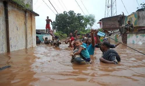
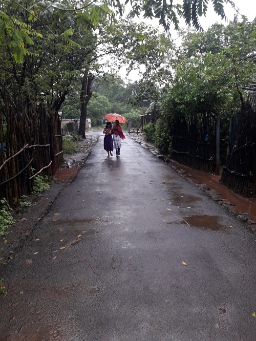
A family in attempt to escape the flood-hit areas in Malkangiri
Image by: Subrat Kumar Pati/101Reporters
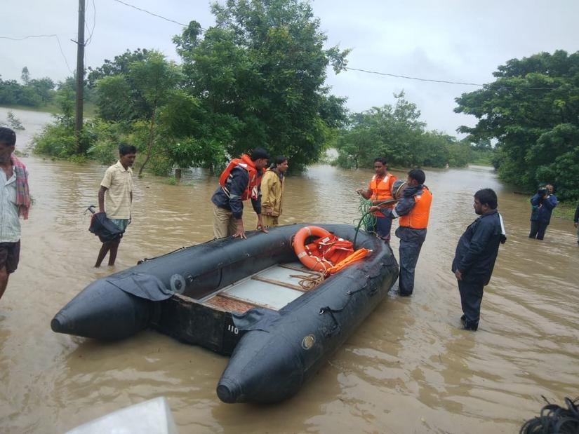
10 families in worst-hit Potaru area rescued, says Malkangiri SP
Malkangiri SP Jagmohan Meena said that rescue and rehablitation operations are on by the police department. He said that the department received information that the low lying area of Potaru, around 15 kms away from Malkangiri town was the worst affected in the district. “We have shifted around 10 families living their to a safer location.They are now stationed at the Potaru police outpost which is a three-story building. Many others are being shifted to other outposts and thanas as well. The department ensured that they get their breakfast. But the officials are, however, struggling to provide lunch due to water logging in many areas. We have taken the help of the Odisha Disaster Response Team (ODRF) to procure and deliver lunch for the rescued families. The ODRF team are taking the help of boats to reach out to more people in need."
Input by Manish Kumar/101Reporters
Odisha govt officials say they are fully prepared to handle situation
Special Relief Commissioner Bishnupad Sethy said that the government was fully prepared for the cyclone. “We are managing it properly. As per the instruction of chief minister, zero casualty was our aim. No casualty has been reported yet. Malkangiri is more affected, rescue and relief operation is going on.
Input by Subrat Kumar Pati/101Reporters
NDRF deployed in Malkangiri; more teams on standby in Rayagada, Gajapati, and Puri
Taking the situation into account, the NDRF and the ODRAF have been deployed in different districts. One NDRF team each has been deployed in Kalahandi, Rayagada, Gajapati, Puri, Nayagarh and Kandhamal districts with 17 boats and other emergency equipment.
Image by: Subrat Kumar Pati/101Reporters
Water-logging in parts of Malkangiri due to heavy rainfall
Video by: Subrat Kumar Pati/101Reporters
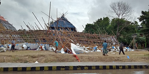
Viswakarma Puja pandals broken in Paradip
Paradip, which is famous for its 15-day long Viswakarma Puja festival has also been affected. Many puja pandals have been broken due to the cyclone.
Input by: Subrat Kumar Pati/101Reporters
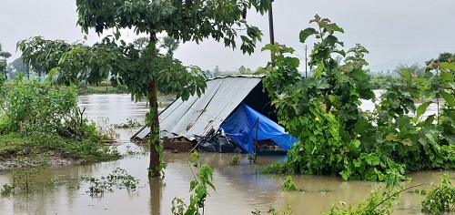
Outer Malkangiri also affected by deluge; many houses submerged
Several parts of outer Malkangiri city and rural areas of the district are now reportedly heavily affected by the cyclonic rains. Several houses have reportedly submerged into water, making many several people homeless.
According to sources, maximum rainfall of 284 mm has been recorded at Malkangiri by the Meteorological department.
Input by: Ravi Rajesh/101Reporters
Cyclone has weakened into ‘deep depression’: Office of the Special Relief Commissioner
Office of the Special Relief Commissioner has said that the Cyclone DAYE has weakened into a deep depression and is laying over south interior Odisha and its neighbourhood.
Input by: Manish Kumar/101Reporters
Partial impact felt in Bhubaneswar; high speed winds pass through coastal city
Bhubaneswar: Impact of cyclone DAYE is felt partially in the state capital, Bhubaneswar. Downpour was reported in the last two days, while winds with more than normal speed have passed through the city since Thursday night. But, the impact is still being felt in the city which is just 60 kilometres away from the coastal town of Puri.
Input by: Manish Kumar/101Reporters
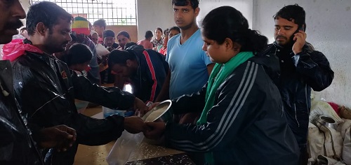
District officials reach out to Malkangiri residents with relief
District officials and other personnel from the state government have jumped onto the bandwagon to reach out to the people of Malkangiri to assist them and provide them relief, as most of the shops and business establishments have closed down due to the heavy rains and partial submergence of many buildings in the area.
Inputs by: Ravi Rajesh/101reporters
CM reviews situation, announces seven day relief for Malkangiri
The Chief Minister has reviewed the whole situation of cyclone threat in the state and the likely damages. He has agreed to sanction relief for seven days at the rate of Rs 60 per person and Rs 45 per day for children who are below the age of 12 years in Malkangiri. All officials have also been directed to extend their helping hand to the people in need.
Input by: Ravi Rajesh/101reporters
Rain intensity decreases in Chitragonda block of Malkangiri
Chitragonda Block: Rains have subsumed in the Chitrogonda block of Malkangiri which hosts the Balimela water reservoir. It rained here for last three days and on Thursday night also downpour was reported. However post 9 pm the intensity has decreased and the life in the area is coming to normalcy. The block also hosts the 151 areas of the district, which were cut-off earlier.
Inputs by: Manish Kumar/101Reporters
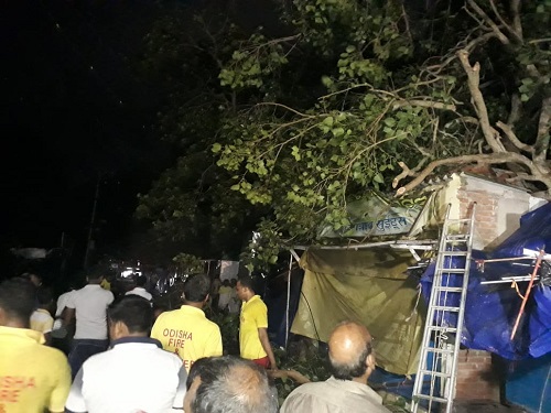
Incidents of tree fall reported in Puri
Puri: A tree fell on Thursday night and blocked roads. The Fire department and ODRAF teams are clearing the roads.
Input by: Subrat Kumar Pati/101Reporters
Water flowing above danger mark in Jalaka river in Balasore
Balasore district: Water is flowing above the danger level in the Jalaka River. The danger level is 4.5 meteres, whereas the water is flowing at 6.3 meteres
Input by: Subrat Kumar Pati/101Reporters
Two gates of Kolab Dam opened as water level increases
Koraput: Water level haws increased in the Kolab Dam and two gates have been opened.
Inputs by: Subrat Kumar Pati/101Reporters
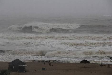
Rough sea conditions in Puri; fishermen advised to avoid venturing out
Odisha fishermen have been advised to stay away from sea owing to rough sea conditions across India’s eastern coast.
Image by Subrat Kumar Pati/101Reporters
Cyclonic storm lies centred over interiors of Odisha, expected to weaken by noon
Cyclone DAYE, which made landfall in Odisha at midnight, has since weakened and will become a Tropical Depression by Friday afternoon. The Tropical Cyclone (now downgraded to a deep depression) will cause heavy rain, thunderstorm and gusty winds around northeastern, eastern, central and western India on Friday, The Weaher Channel reported.
Naveen Patnaik reviews cyclone preparedness
Chief Minister’s Office (CMO) says Odisha Chief Minister Naveen Patnaik reviewed the cyclone preparedness. He has directed concerned departments to remain prepared with adequate relief.
Input: Manish Kumar/101Reporters

Leaves of government officials canceled
Leave of government officials across five districts has been cancelled based on the instructions of Chief Minister Naveen Patnaik. These districts are Ganjam, Gajapati, Khordha, Nayagarh and Puri. However, all other district collectors are instructed to take decisions as per need.
Input by Subrat Kumar Pati/101Reporters
Rainfall in Odisha’s Mayurbhanj
The northern district of Odisha in Baripada (Mayurbhanj), has seen moderate rainfall for the last two days leaving the normal live at tenterhooks. It also rained last night while the intensity subsumed as the day progressed in the district.
By input: Manish Kumar/101Reporters
In Baleswar district, heavy rains cause flood-like situation
Incessant heavy rainfall in Baleswar district has caused flood-like situation in several parts, throwing normal life out of gear. Water is flowing well over the 4.5 metre danger level in Jalaka river. At the last check, water was flowing at 6.3 metres in Jalaka river. The district’s Marthani, Baharda, Dudhahansa, Sadanandpur, Barungadia, Chakarai, Darada, Gadapada, Routpada panchayats are affected, whereas a flood like situation continued in the Basta block.
Input by Subrat kumar Pati, 101Reporters
Water level rises in Balimela dam in Malkangiri’s Chitrakonda
The water level increased in Balimela water reservoir in the Chitrakonda area of Malkangiri district. If the water continues to rise at the current rate, the authorities will have to open the gates of the dam soon. This puts in danger the Gurupriya Setu (Bridge).
Meanwhile, water has started flooding in different public places in the town and the healthcare services are affected in Janbai hospital due to water lodging.
Input by Subrat Kumar Pati, 101Reporters
IMD warns fishermen from West Bengal, Odisha, Andhra against venturing into sea
The Indian Meteorological Department said that the fishermen from West Bengal, Odisha and Andhra Pradesh should not venture out into the sea owing to deep depression across the east coast. Fishermen from West Bengal are advised not to venture into the sea before noon, in south and north Odisha they are advised to refrain from entering sea at least for the next 24 hours.
In Andhra Pradesh, the IMD advised the fishermen to not go fishing within the next 36 hours.
Heavy rains may continue over next 24 hours
Heavy rainfall was recorded in sourh and western Odisha as Cyclone DAYE made landfall in Odisha around midnight. The downpoyur is expected to continue till next 24 hours as well. The IMD has issued warnings of heavy rainfall in Gajapati, Ganjam, Puri, Rayagada, Kalahandi, Koraput, Malkangiri and Nabarangpur districts.
Input by Subrat Kumar Pati, 101Reporters
NDRF deployed in parts of Odisha
The National Disaster Response Force (NDRF) has deployed its teams in Kalahandi, Raygada, Gajapati, Puri, Nayagarh and Khandamal with several boats and other emergency equipment required to combat the situation. Meanwhile the Odisha Disaster Rapid Action Force teams have been deployed in Ganjam, Koraput, Nabarangpur and Malkangiri districts.
Input by Subrat Kumar Pati, 101Reporters
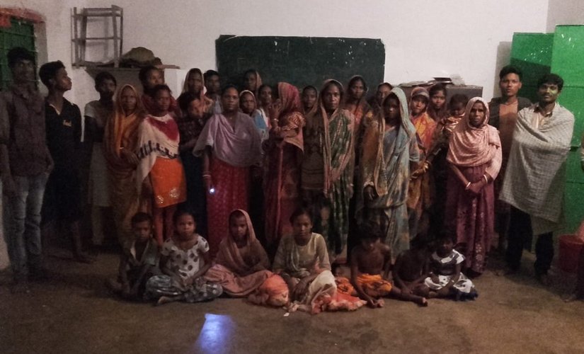
Officials rescue villagers from coastal Odisha near Chilika area
Office of the Special Relief Commissioner, Odisha shares pictures of evacuated people from the Atharbatia and Dungamal gram panchayats of the Chilika block in the coastal state. The officials have assured all assistance to the people.
Input by Manish Kumar, 101Reporters
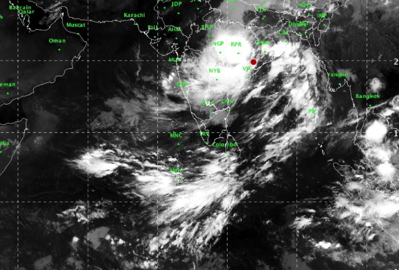
Cyclone DAYE: Latest Satelite Image
According to the the IMD, Cyclone DAYE lay centred over south interior Odisha and neighbourhood near latitude 20.00N and longitude 83.70E, about 65 km east-southeast of Titlagarh (Odisha). Here is the latest satelite image of the cyclone’s progression.
All rivers in Malkangiri district flooded following heavy rainfall
The Kankarkonda, Korkonda, Poteru and MV 37 rivers have swollen and are flowing above the red mark following heavy rainfall. The road transport between Malkangiri and Chattisgarh has been affected due to heavy rains.
Input by Subrat Kumar Pati, 101Reporters
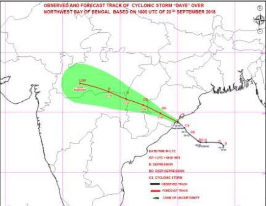
Cyclone DAYE to weaken over next 12 hours: IMD
The cyclonic storm DAYE weakened into a deep depression at 05.30 am today, and lay centred over south interior Odisha and neighbourhood near latitude 20.0° N and longitude 83.7° E, about 65 km eastsoutheast of Titlagarh (Odisha).
It would continue to move westnorthwestwards and weaken gradually into a depression during next 12 hours, the IMD said in an update released Friday.
Yellow warning for heavy rainfall in coastal Odisha issued
The IMD predicted rainfall at most places in Odisha, with heavy to very heavy falls lashing parts of south Odisha. Rainfall is also likely over isolated places in north
Odisha.
Myanmar named Cyclone DAYE
Tropical cyclones are named to provide ease of communication between forecasters and the general public regarding forecasts and warnings, which sometime must be shared between countries or regions using different dialect.
In case of the Indian Ocean basin (including Arabian Sea & Bay of Bengal), eight countries take turns in naming cyclones. The latest, Cyclone DAYE has been named by Myanmar.
NDMA issues cyclone warning, cites safety and evacuation guidelines during storm
The India Meteorological Department (IMD) issued a warning on Thursday for cyclonic storm DAYE to hit southern Odisha and coastal Andhra Pradesh. As per the NDMA guidelines, action in the event of a cyclone threat can broadly be divided into four categories: immediately before the cyclone season, when cyclone alerts and warnings are communicated, when evacuations are advised, when the cyclone has crossed the coast. Some of the do’s and dont’s in the current scenario included hoarding dry non-perishable food items, keep an eye out for the warning and stay tuned to the radio warnings issued by official sources.
You can read the whole list of Do’s and Don’ts hereOdisha to face gusty winds of speed 60-70 kmph over next few hours
Squally wind speed reaching 60-70 kmph gusting to 80 kmph is very likely along and off Odisha and north Andhra Pradesh coasts. Apart from heavy rains, the high-wind speeds are expected to damage thatched roof houses and communication cables in parts of Odisha. The IMD has issued a warning to fishermen advising them to keep off the sea for the next two days.
Cyclone DAYE will bring heavy rain to central, north-west India; will head to Maharashtra over weekend
According to a report in _The Hindu Business Line, a_fter crossing the Odisha coast, the track of the latest Bay of Bengal cyclone will head in a classical west-north-west direction (diagonal across Central and Western India) over the weekend and early next week.
The cyclonic depression having peaked into a full-fledged storm early on Friday will have gusty wind speeds of up to 70 to 80 km/hr and it would continue to move west-north-west over land after crossing the Odisha coast, and weaken back into a deep depression on Friday next week.
IMD says road, rail, communication channels to be hit by Cyclone DAYE
The IMD has predicted damage to thatched hut, roads, crops and minor damage to power and communication lines in Gajapati, Ganjam, Khordha, Nayagarh and Puri districts at the time of landfall of Cyclone DAYE. Local cautionary Signal Number LC-III to be kept hoisted at all ports of Odisha, it said.