 "PM Modi meets Manipur violence victims in first visit since 2023 unrest")
 "'Mizoram is at the forefront now': PM Modi inaugurates Bairabi-Sairang New Rail line in Aizawl")
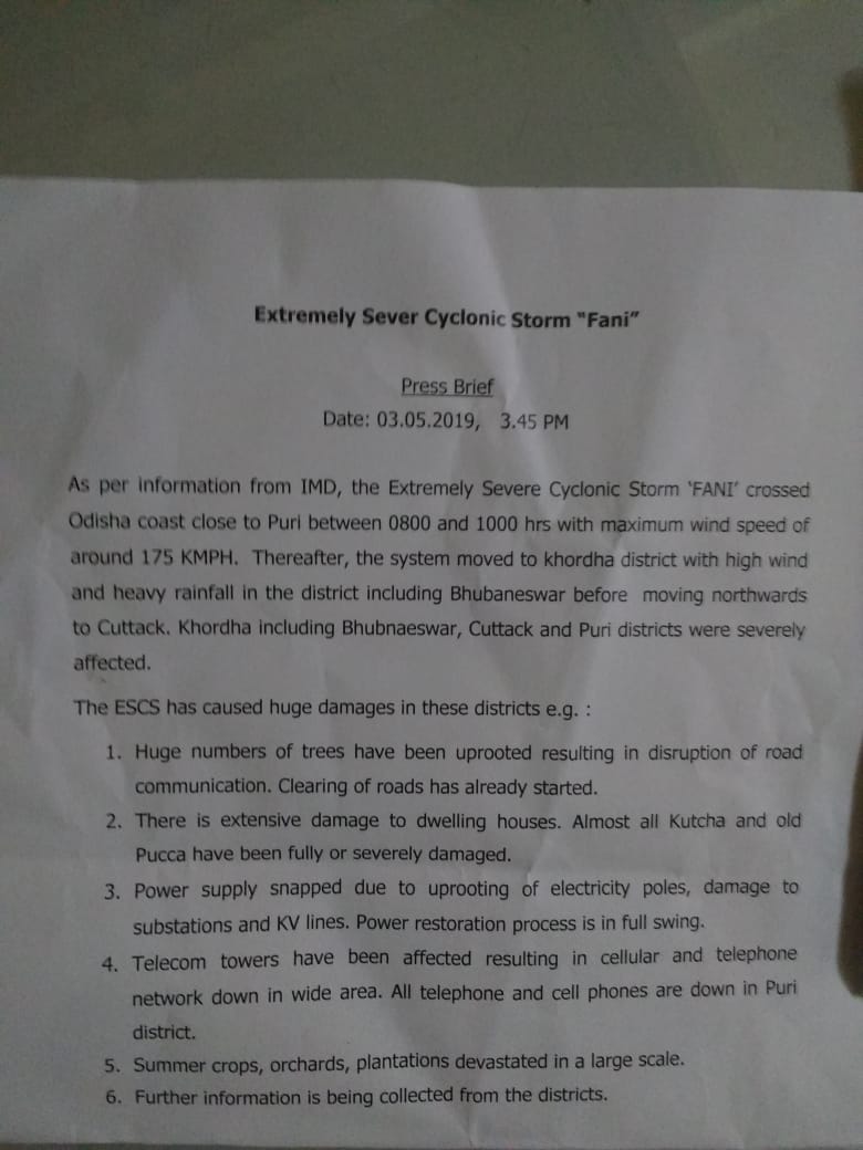
Cyclone Fani in Odisha, Andhra Pradesh, West Bengal, Tamil Nadu, LATEST News and updates | Andhra Pradesh chief minister N Chandrababu Naidu accused the Election Commission of having scuttled his plans on cyclone rescue and relief operations. A special notice from the West Bengal government says, “Every primary and high school in the districts should be prepared for any sort of emergency. The keys should be handed over to either local people or the teachers. No flood victim or evacuated villager should wait for shelter.” At a press conference, Sanjeev Bandhopadhyay, Deputy DGM, Indian Meteorological Department, said, “Cyclone Fani has weakened to a ‘very severe cyclonic storm’ and is now 200 kilometres southwest from the coastal area of Digha in East Midnapore district and 340 kilometres southwest of Kolkata. The cyclone is expected to weaken further in the next nine hours. The cyclone is expected to make landfall in West Bengal at a speed of 80-115 kmph at midnight. There is a possibility of the cyclone entering earlier in the evening." At a press conference, BJP’s general secretary Kailash Vijayvargia said, “Eight districts in West Bengal will be affected due to cyclone Fani. All political programmes remain cancelled from the BJP. We request all to stay in their districts. We pray this doesn’t create much damage. BJP will keep politics aside. If the state government needs any assistance from us, our party workers are ready to help in rescue and relief. We are standing by the CM.” A 32-year-old woman gave birth to a baby girl at the Railway Hospital in Bhubaneswar at 11:03 am, just as Cyclone Fani was passing through Odisha. The baby was named after the cyclonic storm, Fani, reported ANI. The woman is a railway employee and works as a helper at at the Coach Repair Workshop at Mancheswar. Both the mother and the child are fine. The cyclone had put a lot of pregnant women in danger, it was reported on Thursday. Bhubaneswar has borne some of the worst brunt of Cyclone Fani with widespread damage at not just the city airport but across the city. The city now stares at one of the most extensive reconstruction efforts. Sanjeev Bandhopadhyay, Deputy DGM Meteorological Department has held a press conference to announce that the “extremely severe cyclonic storm” had crossed Puri from 8 am to 10 am, the eye of the storm is now on land and that it has weakened to a “severe cyclonic storm.” On 4 May, the storm will enter Bangladesh and from 5 May onwards things will be normalised, he said. News reports have said that six people have died in Kendrapada and Nayapalli in Odisha in what are the very first reports of casualty from the state. The Odisha government has not confirmed any deaths yet. With the cyclonic storm showing the very first signs of letting up in Odisha, National Disaster Response Force teams have already begun work in Balasore district of Odisha and Srikakulam in Andhra Pradesh. The India Meteorological Department has said that Fani looks to weaken in the next three hours. At his rally in Rajasthan’s Hindaun, Narendra Modi promised a Rs 1,000 crore relief package for Cyclone Fani. “I conducted a meeting on the level of preparedness,” the prime minister said on Friday. The concrete ghats of old and new Digha sea beach gave away at around 11 am on Friday, as the cyclone hit Bengal. The West Bengal government has been evacuating tourists on a war footing. So far, 70,000 families have been evacuated from the coastal belt of Bengal already and further evacuation efforts are underway. Indian Navy’s P-8I and Dornier are being scheduled to be launched on Friday afternoon to undertake aerial survey to assess the extent of impact and devastation after Cyclone Fani crossed the Odisha coast. Cyclone Fani has moved away from Andhra Pradesh, confirmed India Met Department. Speaking to ANI, Mrityunjay Mohapatra from IMD, Delhi said, “So, we have issued a de-warning. Three districts in Andhra Pradesh were impacted by heavy rainfall.” Kolkata airport is functional, however, airport authorities have asked airlines to cancel both domestic and international flights from 3:00 pm on Friday till 8:30 am on Saturday in the wake of cyclone Fani. Technicians and engineers along with emergency systems have been put on standby at Kolkata airport. North coastal Andhra Pradesh is facing a flood threat as Cyclone Fani has crossed the Indian coast 15 kilometres off Gopalpur in Odisha. Rivers originating from Odisha are expected to be in spate, Srikakulam collector, J Nivas said. According to the latest IMD bulletin, the impact is likely to reduce and Cyclone Fani is likely to move towards the West Bengal coast. The system is very likely to continue to move north-northeastwards, weaken gradually and emerge into Gangetic West Bengal as a severe cyclonic storm with a wind speed of 90-100 kmph gusting to 115 kmph by early Saturday. Fani is very likely to move north-northeastwards and cross Odisha Coast between Gopalpur and Chandbali, close to Puri before 11 am with a maximum sustained wind speed of 170-180 kmph gusting to 200 kmph. After the landfall., the system is very likely to continue to move north-northeastwards, weaken gradually and emerge into Gangetic West Bengal as a severe cyclonic storm with a wind speed of 90-100 kmph gusting to 115 kmph by early Saturday. It is very likely to continue to move further north-northeastwards and emerge into Bangladesh on 4 May evening as a cyclonic storm with a wind speed of 60-70 kmph gusting to 80 kmph. Severe cyclonic storm Fani made landfall at 8 am. Part of the eye lies over land at 8.30 am. The entire process of eye entering into the land will be completed in next two hours. Current wind speed of the storm is 175 to 185 kmph in Puri gusting to 195 kmph. Puri reported maximum sustained windspeed of 142 km/h gusting to 174 km/h at 7:30 am today. Reports said that even with a wind speed of 175 kmph gusting up to 200 kmph, that is not just the worry with Cyclone Fani. The tidal surge, which experts have predicted could go up to 30 feet, that will submerge several coastal and low lying areas. The India Met Department has confirmed the impact of the landfall process has begun already in Odisha. The wind speed of the storm is 175 kmph. The eye of the storm will hit the landmass at point of time now, said Odisha Special Relief Commissioner Bishnupada Sethi. Speaking to reporters, IMD chief HR Biswas said, “The impact of landfall process has started. Fani will make a landfall between 8-11 am. In the morning at 6:31 am it was 70 km south-southwest of Puri, it is moving now.” Cyclone Fani is making landfall right now near Puri in Odisha as a Category 4 storm. Meteorologists have dubbed the extremely severe storm as one of the strongest landfalling cyclones in the country’s recorded history. Cyclone Fani has reached close to Odisha coast near Puri. The wind speed of the storm is 175 kmph. The eye of the storm will hit the landmass at point of time now, said Odisha Special Relief Commissioner Bishnupada Sethi. Cyclone Fani is very likely to cross Odisha Coast between Gopalpur and Chandbali, south of Puri during 3 May forenoon with maximum sustained wind speed of 170-180 kmph gusting to 200 kmph. Landfall process is very likely to continue till noon of Friday. Being touted as India’s worst cyclone in the past 20 years, Cyclone Fani is expected to make landfall on the coast of Odisha near Puri around noon today. Reports, however, have conflicting time regarding the landfall. While some said the landfall process will start from 8 am, other reports said the landfall can be around noon or even later even in the day. The Indian Meteorological Department’s morning bulletin states that the extremely severe Cyclone Fani law centered about 80 kilometres south-southwest of Puri, 65 kilometres southeast of Gopalpur and 280 kilometres east-northeast of Visakhapatnam in Andhra Pradesh. It is very likely to move north-northeastwards and cross Odisha Coast near to Puri in between 8 to 10 am with maximum sustained wind speed of 170-180 kmph gusting to 200 kmph. The landfall process is very likely to continue till noon/afternoon of 3rd May. The ‘extremely severe’ cyclonic storm Fani is expected to make a landfall near the pilgrim town of Puri in Odisha on Friday early afternoon. The state government has issued a safety advisory and asked people to remain indoors. The landfall is expected to last for a period of four to five hours and over 11 lakh people have been evacuated all over Odisha from vulnerable and low-lying areas. The most vulnerable districts are Gajapati, Ganjam, Khurda, Puri, Naygarh, Cuttack, Jagatsinghpur, Kendrapara, Jajpur, Bhadrak and Balasore. Around 4,000 shelters, including 880 specially designed cyclone centres, are housing the evacuees. All shops, business establishments, private and government offices except those associated with relief and rescue operations will remain closed. Chief Secretary AP Padhi said, “There may be a lull before the storm, but it will be the most dangerous phase and people should be extremely careful and keep indoor.” Fani, according to sources, has gathered speed and is rolling dangerously towards the coast clocking 17 km per hour and lay 275 km south-southwest of Puri around 9.30 pm on 2 May. Navy, Air Force, Army and Coast Guard have already been put on high alert and personnel of National Disaster Response Force, Odisha Disaster Rapid Action Force and fire service have also been deployed in vulnerable areas. Leave of all doctors and health officials and police personnel have been cancelled. The Railways said a large number trains have been cancelled as a precautionary measure. The East Coast Railway has cancelled over 147 trains till 4 May, an ECoR official said in Bhubaneswar. Three special trains were run from Puri to Howrah and Shalimar in West Bengal on Thursday to facilitate the evacuation of tourists. Flight operations from Bhubaneswar airport are also suspended for 24 hours from Thursday midnight. India’s biggest oil and gas producer ONGC has removed close to 500 of its employees from offshore installations in the Bay of Bengal and moved drilling rigs to safer locations. After crossing Odisha, the cyclone is likely to move towards West Bengal and is still likely to impact parts of the northeast, Andhra Pradesh and Tamil Nadu. There is forecast of massive tides that could surge up to 1.5 metres during the landfall. Fishermen have been advised against venturing into the sea. With inputs from PTI
Cyclone Fani updates: Meghalaya govt seeks deployment of NDRF as hurricane heads towards West Bengal
Cyclone Fani LIVE Updates: A special notice from the West Bengal government says, “Every primary and high school in the districts should be prepared for any sort of emergency. The keys should be handed over to either local people or the teachers. No flood victim or evacuated villager should wait for shelter.”
)
Cyclone Fani latest update from Odisha
Bhubaneswar Airport to resume operations at 1 pm on Saturday
Cyclone Fani latest update from Odisha
Aerial survey of Puri conducted by naval Dornier aircraft
Cyclone Fani latest update from West Bengal
Cyclone Fani makes landfall in West Bengal
Cyclone Fani latest update from Meghalaya
Meghalaya govt seeks deployment of NDRF in state
The Meghalaya government has sought deployment of a platoon of the National Disaster Response Force (NDRF) in the state in view of Cyclone Fani, officials said.
The extremely severe cyclonic storm made landfall in Odisha on Friday morning. It is gradually heading towards West Bengal and from there it is likely to move towards the north-east, the officials said.
One NDRF platoon, comprising 25 to 30 personnel, has been sought from Guwahati, Meghalaya Revenue and Disaster Minister Kyrmen Shylla said.
The IMD has warned of thundersquall accompanied with gusty winds and heavy rains for the next 48 hours across the northeastern states, including Meghalaya.
“We have requested the NDRF to deploy at least one platoon at the state capital. The NDRF personnel would assist the state in case of any emergency,” Shylla said. — PTI
Cyclone Fani latest update
Vodafone, Airtel issue statements on Cyclone Fani
Airtel in its statement said that war rooms with dedicated teams have been established in the state/circle offices to monitor impact of operations and coordinate quick recovery.
It also said that SMS has been made free in three affected states for 5 days.
Vodafone, on the other hand, said that the helpline number 1938 is available for people in case of emergency.
“Proactively, we have ensured sufficient fuel supply to our sites across all locations, and stocking at strategic locations,” it said.
Cyclone Fani latest update
56 more trains cancelled by East Coast Railway
In addition to the 169 trains that were cancelled, 56 more trains were cancelled by the East Coast Railway in view of Cyclone Fani.
Input by Monalisa Patsani/101Reporters
Cyclone Fani latest update from West Bengal
Control room set up in Kolkata under supervision of Mayor Firhad Hakim
A control room has been setup opened in Kolkata Municipal Corporation premises under the supervision of Kolkata Mayor, Firhad Hakim.
The control room will be functioning 24×7 to take oversee relief and evacuation work in the state.
Input by SS Parveen/101Reporters

Cyclone Fani latest update from Odisha
160 reportedly injured in Puri
“As per telephonic information, in Puri, extensive damage (was done) to kuchha houses, old buildings and temporary shops. There are no confirmed reports of deaths, but 160 have been reportedly injured. Power and telecom is completely down. NDRF and state forces are clearing roads,” ANI quoted a central government spokesperson as saying.
Cyclone Fani latest update from Odisha
Visuals from Bhubaneswar at 5 pm
Cyclond Fani latest update from Assam
Cyclone Fani to hit Assam tomorrow
According to News18 , there will be heavy to very heavy rainfall in Assam in at least ten places, including in Dhubri, Kokrajhar, Goalpara, Bongaigaon, Chirang, Barpeta, Kamrup, South Salmara, Mankachar and parts of Baksa.
IMD has issued yellow and orange category warnings for the state.
Cyclone Fani latest update from West Bengal
185 clay houses, pucca houses damaged in last few hours in East Medinipur
In East Medinipur 185 clay houses and pucca houses have been damaged in the last few hours. Till the afternoon – 25 houses were broken in Dattan, 47 houses destroyed in block 2, 14 in Kharagpur block, 51 in Midnapore city, 14 in Midnapore Sadar block, 5 in Narayangarh, 9 in Salbani, 20 houses have been damaged in the block number 3 in Chandrakona Road. A total of 185 homes were destroyed. 9 people were injured in different accidents.
Input by A Ghose/101Reporters
Cyclone Fani latest update from West Bengal
Visuals from Kolkata
Cyclone Fani latest update from West Bengal
Roof of six houses in East Midnapore destroyed
The roof of six houses in East Midnapore’s Panshkura has been totally destroyed as Fani approaches the coastal region of West Bengal. There is no electricity in the villages since the morning.
Input by A Ghose/101Reporters
Cyclone Fani latest update from Andhra Pradesh
EC is biased in implementing MCC: Chandrababu Naidu
Naidu alleged that the EC is biased in implementing Model Code of Conduct by allowing Prime Minister Narendra Modi to hold cyclone reviews and offering central assistance to cyclone-hit states.
Cyclone Fani latest update from Andhra Pradesh
Chandrababu Naidu accuses EC of scuttling rescue and relief operations
Andhra Pradesh chief minister N Chandrababu Naidu accused the Election Commission of having scuttled his plans on cyclone rescue and relief operations.
He said the EC gave him permission to monitor the situation only after Cyclone Fani had crossed Andhra Pradesh’s coast.
“Yet we managed the disaster well by ensuring no casualties and minimise damages,” Naidu said, asking the EC to enforce the Model Code of Conduct from public interest point of view
Input by Nagaraja Gali/101Reporters
Cyclone Fani latest update from West Bengal
Police in Kolkata remove all street hawkers from city
Input by Ashok Nath Dey/101Reporters
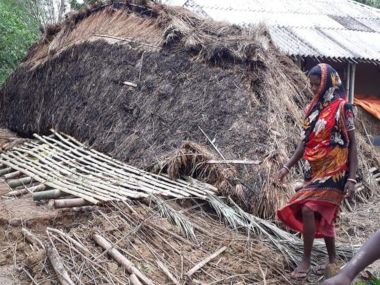
Cyclone Fani latest update from Odisha
Initial estimates of damage and destruction by Fani in Odisha
Input by Bibhuti Mohapatro/101Reporters
Cyclone Fani latest update from Odisha
Telecom tower toppled in Cuttack
Cyclone Fani latest update
East Coast Railway cancels another 19 trains
Adding to the 157 trains that have already been cancelled, East Coast Railway cancelled another 19 trains in view of Cyclone Fani.
Input by SS Parveen/101Reporters

Cyclone Fani latest update from Andhra Pradesh
Crops damaged in Andhra Pradesh
Crops were damaged in 553 hectares in six mandals in Andhra Pradesh. Fani delivered a deadly blow to banana and coconut plantations.
2,129 electric polls and 218 cell towers were razed to the ground by high-speed winds. Communication system has been paralyzed in more than half a dozen mandals.
Input by Nagaraj Gali/101Reporters
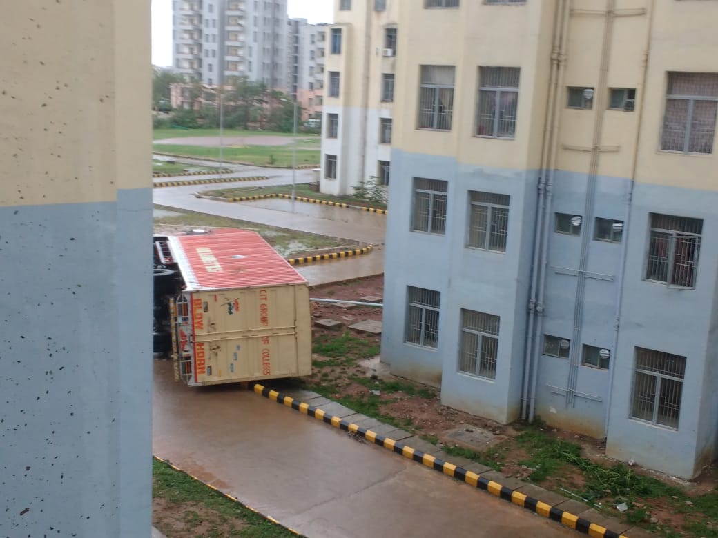
Cyclone Fani latest update from Odisha
Bus toppled at Gita Engineering College in Bhubaneswar
Input by Monalisa Patsani/101Reporters
Cyclone Fani latest update from West Bengal
Schools should be prepared for any emergency: West Bengal govt
A special notice from the West Bengal government says, “Every primary and high school in the districts should be prepared for any sort of emergency. The keys should be handed over to either local people or the teachers. No flood victim or evacuated villager should wait for shelter.”
Input by A Ghose/101Reporters
Cyclone Fani latest update
Cyclone has weakened to ‘very severe cyclonic storm’: IMD
In a press conference, Sanjeev Bandhopadhyay, Deputy DGM, Indian Meteorological Department, said, “Cyclone Fani has weakened to a ‘very severe cyclonic storm’ and is now 200 kilometres southwest from the coastal area of Digha in East Midnapore district and 340 kilometres southwest of Kolkata. The cyclone is expected to weaken further in the next nine hours. The cyclone is expected to make landfall in West Bengal at a speed of 80-115 kmph at midnight. There is a possibility of the cyclone entering earlier in the evening."
Input by SS Parveen/101Reporters
Cyclone Fani latest update from West Bengal
BJP’s vice-president of West Bengal unit writes to state’s chief secretary
Jay Prakash Majumdar, BJP’s vice-president of West Bengal, has written to the chief secretary of the state to offer their support and services in view of Cyclone Fani.
Input by A Ghose/101Reporters

Cyclone Fani latest update from West Bengal
Air India flight from Kolkata to Bagdogra cancelled
An Air India flight (AI 721) was supposed to take off at 1.40 pm from Kolkata to Bagdogra, but it was cancelled due to heavy rains and wind.
Now, the flight from Kolkata airport won’t take off as per as orders due to Cyclone Fani. So, the passengers of the Air India flight are protesting inside Netaji Subhash Chandra Bose Airport.
Input by SS Parveen/101Reporters
Cyclone Fani latest update from Odisha
Water-logging in Bubaneswar, Cuttack; roof of Bhubaneswar Railway station blown away
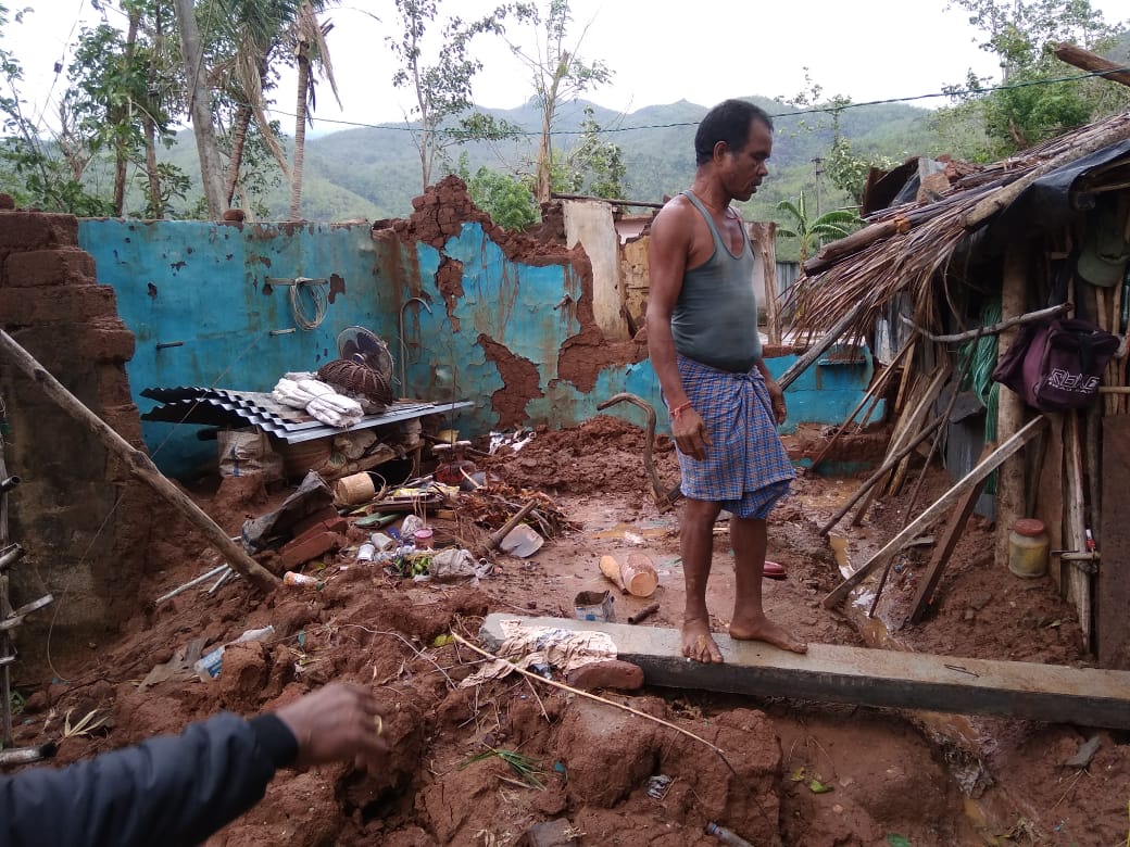
Cyclone Fani wrecked many parts of Odisha. Continuous downpour and wind has uprooted many trees, telecom towers, electric poles in Bhubaneswar, Cuttack, Khurda, Puri and other parts of coastal areas of the state.
Water-logging has been witnessed in Bhubaneswar and Cuttack, while communication in Puri has totally broken down. Bhubaneswar Railway Station and Biju Patnaik International Airport have been also damaged.
The roof of Bhubaneswar Railway station has been blown away. The roof of recently renovated Kalinga Stadium has also been damaged. Though the wind speed is slowly decreasing in Khurda area, rains are likely to continue.
Input by Monalisa Patsani/101Reporters
Cyclone Fani latest update from West Bengal
House burns down in South 24 Parganas, residents escape
A house burnt down due to an electrical fire at Mohammad Nagar village of Nandkumar Pur Gram Panchayat in Rayadighi, South 24 Parganas as the effect of Fani intensified in the area.
However, the residents managed to escape.
Input by A Ghose/101Reporters
Cyclone Fani latest update from Andhra Pradesh
Aftermath of Cyclone Fani landfall in Andhra Pradesh’s Srikakulam district
Cyclone Fani latest update from Odisha
WATCH: Indian Coast Guard loads relief
The Indian Coast Guard has begun operations to send relief to people. The video shows personnel loading items on to a chopper.
Cyclone Fani latest update from West Bengal
Metro services could be held up in Kolkata
Metro services from Kavi Subhash to Dumdum stations in Kolkata have been normal till 2:50 pm. In view of the cyclone, services from Mahanayak Uttam Kumar to Kavi Subhash and from Dumdum to Noapara may be regulated or suspended if the situation so demands, any time on 3 and 4 May, 2019, the authorities have informed.
A Ghose/101Reporters
Cyclone Fani latest update from Odisha
WATCH: AIIMS roof blows away in wind
Extensive damages were done to the structure of AIIMS Bhubaneswar due to Cyclone Fani, the Press Information Bureau reported. “All patients, staff, students are safe. Many water tanks have blown off, lighting poles were down, air conditioners were damaged. We have enough supplies and are ready to support the state,” said health secretary Preeti Sudan.
Cyclone Fani latest update from West Bengal
Will join hands with Mamata to aid in Fani rescue work, says BJP
At a press conference, BJP’s general secretary Kailash Vijayvargia said, “Eight districts in West Bengal will be affected due to cyclone Fani. All political programmes remain cancelled from the BJP. We request all to stay in their districts. We pray this doesn’t create much damage. BJP will keep politics aside. If the state government needs any assistance from us, our party workers are ready to help in rescue and relief. We are standing by the CM.”
A Ghose/101Reporters
Cyclone Fani latest update from Odisha
Child born during storm named ‘Fani’
A 32-year-old woman gave birth to a baby girl at the Railway Hospital in Bhubaneswar at 11:03 am, just as Cyclone Fani was passing through Odisha. The baby was named after the cyclonic storm, Fani, reported ANI.
The woman is a railway employee and works as a helper at at the Coach Repair Workshop at Mancheswar. Both the mother and the child are fine. The cyclone had put a lot of pregnant women in danger, it was reported on Thursday.
Cyclone Fani latest update from Odisha
Bhubaneswar suffers worst
Bhubaneswar has borne some of the worst brunt of Cyclone Fani with widespread damage at not just the city airport but across the city. The city now stares at one of the most extensive reconstruction efforts.
Video by Debi Mohanty
Cyclone Fani latest update from West Bengal
Ferry services stopped across Ganga
Ferry services from Babughat in Kolkata have been stopped from 1 pm on Friday and will resume on Saturday if the weather conditions improve.
SS Parveen/101Reporters
Cyclone Fani latest update from Odisha
WATCH: Glass wall shatters in Bhubaneswar hostel
Cyclone Fani may have weakened to a ‘severe’ storm but its impact was such that a glass wall at the KIIT hostel in Bhubaneswar shattered as a result of gusty winds.
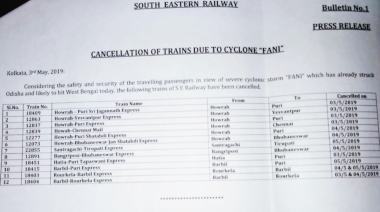
Twelve additional trains cancelled
Twelve more trains have been cancelled by the South Eastern Railway in the aftermath of Cyclone Fani. As of now 157 trains have been cancelled by the East Coast Railway and 12 by the South East Railway.
SS Parveen/101Reporters
Cyclone Fani latest update
IMD says storm has weakened to ‘severe’
Sanjeev Bandhopadhyay, Deputy DGM Meteorological Department has held a press conference to announce that the “extremely severe cyclonic storm” had crossed Puri from 8 am to 10 am, the eye of the storm is now on land and that it has weakened to a “severe cyclonic storm.”
“On 4 May it will enter Bangladesh and from 5 May onwards things will be normalised. Heavy rains and extremely heavy rains will be witnessed in one or two places in the coastal areas of West Bengal from evening to early Saturday morning. The cyclone is likely to enter Kolkata in the evening and cause heavy rains till Saturday morning,” Bandhopadhyay added.
SS Parveen/101Reporters
Cyclone Fani latest update
Indian Coast Guard DIG says he is keeping close watch
MA Warsi, the DIG of the Indian Coast Guard said while the speed of the wind as the cyclone hit Odisha was more than 190 kmph, no casualties been noted by the Coast Guard yet. “The weather conditions are still bad, there is heavy rainfall and strong movement of wind in Odisha,” Warsi said.
“Once in West Bengal, it will move in the north-northeast direction and we are continuously monitoring it. IMD Kolkata has informed us that we will see the effect of Fani till the evening. They have also predicted that West Bengal will see a wind speed of 90-100 kmph,” he added.
A Ghose/101Reporters
Cyclone Fani latest update from Odisha
Six people dead in state, say reports
News reports have said that six people have died in Kendrapada and Nayapalli in Odisha in what are the very first reports of casualty from the state. The Odisha government has not confirmed any deaths yet. News18 has reported that the deaths occured due to wall collapses.