
 "Weather Report | Woes of farmers not going to end: A wet week is ahead for most parts of North India")
It’s raining “Hailstorm ’’ across the country, after a very warm start of March many parts of India experienced a thunderous week with moderate to heavy rain, hailstorm and strong winds swept each and every state since 15 March. Farmers across various regions in the country are affected by the early beginning of the pre-monsoon rains this year. A strong Western Disturbance over north and central India with the additional wind convergence in the peninsula pulled out a lot of moist winds from the Bay of Bengal and Arabian Sea which led to a very conducive atmosphere for widespread thunderstorm development in India. Major metropolitan cities in the country experienced rains in the single spell very uncommon in the month of March. On 16 March Mumbai’s base observatory recorded 0.1mm rainfall while the intensity of rains varied in other parts of Mumbai, on the same evening Pune recorded 4.0 mm rainfall with hail storms at spots. On 17 March moderate to heavy rains lashed various parts of south India when Chennai airport recorded 65mm while the city observatory clocked 25mm of rain. By 18 March Hyderabad recorded 19 mm rainfall, Kolkata 2 mm, Delhi airport 5.0 mm. The rainfall intensity varied from place to place in Delhi NCR as Gurgaon recorded 39.5 mm of rain, Ayanagar 9.2 mm. Amid rain and hailstorms, the maximum temperatures have come down to below normal, On 18 March Safdarjung observatory in Delhi reported 25.3°c which was 5.1°c below normal for the day, as the rains hit in the late afternoon and evening it fell up to 17°c in most parts of national capital region brought back cooling very well felt by the citizens on Saturday evening. It’s not just the larger cities but also other regions of the country that have experienced the wet week. Weather conditions have been cold over the Himalayas on 18 March: Banihal in Kashmir recorded 7.2°c maximum temperature and 69 mm rainfall. Kufri: 6.6°c Mussoorie: 9.2°c Shimla: 11.2°c Tehri: 11.4°c Bhuntar: 14.2°c Solan: 15.2°c Mandi: 15.6°c Dehradun: 20.1°c Una: 21.4°c [caption id=“attachment_12318522” align=“alignnone” width=“644”] Maximum temperature anomaly over India on 18 March, 2023 was at least 5 to 10 degrees below normal at many states[/caption] Moderate to heavy rains lashed parts of Uttarakhand, rainfall accumulation ending 8:30 AM on 18 March: Nainital: 62.0mm Khanpur: 43.0mm Roshnabad: 33.3mm Haridwar: 30.2mm Narendranagar: 30.0mm Rikhnikhal: 29.0mm Dehradun: 25.1mm Rishikesh: 23.6mm Dhanolti: 22.0mm Raiwala: 21.0mm Satpuli: 16.5mm Jakholi: 15.0mm Mussoorie: 14.5mm Smaller towns in the central and northern parts of India continue to experience moderate to heavy rains and hailstorms leading to widespread crop damage in the region. Moderate to heavy rainfall in the plains of North India ending 8:30 AM on 18 March: Rajasthan Sapotra: 64mm Jamwa Ramgarh: 55mm Dhaulpur: 36mm Mandryal: 31mm Sarmathura: 28mm Gangapur: 28mm Rajakheda: 25mm Karauli: 21mm Punjab Nabha: 61.0 mm Raikot: 36.5 mm Barnala: 34.0 mm Patiala: 25.6 mm Halwara: 25.6 mm (88.4 mm 2 days) Muzaffarnagar: 18.0 mm. Madhya Pradesh rains in the period of 24 hours till 8:30 AM on 18 March: Badi: 64.0 mm Barghat: 58.0 mm Birsa: 51.0 mm Shahpur: 48.0 mm Amarwara: 31.0 mm Bairad: 30.5 mm Ghatigaon: 24.4 mm Amarkantak: 23.2 mm Pachmarhi: 22.0 Bhind: 22.0 mm Ratlam: 21.0 mm Chhindwara: 13.8 mm As the western disturbance continues to move eastward, the weather conditions become more wet over East India as the moisture incursion from the bay of Bengal is helping in stronger cloud development. Heavy to very heavy rains occurred in Odisha, while moderate to heavy rains are recorded from parts of Jharkhand, Chhattisgarh and West Bengal Rainfall ending 8:30 AM on 19 March: Odisha Jeypore: 148.8 mm Koraput: 122.0 mm Balasore SEOC: 102.0 mm Remuna: 91.0 mm Similiguda: 77.0 mm Chhattisgarh Sukma: 58.4 mm Bastanaar: 58.1 mm Magarlod: 42.3 mm West Bengal Purulia: 25.0 mm Digha: 23.1 mm Asansol: 19.0 mm Haldia: 10.3 mm Midnapore: 7.0 mm Jharkhand Jamshedpur: 18.3 mm Ranchi: 6.2 mm In the pre-monsoon period so far 14 subdivisions in the country received large excess rainfall, 5 had excess, 3 had normal while 14 subdivisions have recorded deficient rainfall till 19 March. The Country as a whole received 14.7 mm rainfall against the normal of 17.9 mm, departure from normal came down to -18 per cent from -74 per cent on 11 March. Subdivision-wise seasonal rainfall in the period of 1-19 March, 2023: • Southern Peninsula: Actual 20.5 mm against the average of 9.2 mm, +123 per cent departure from normal. • East & North East India: Actual 17.2 mm against the average of 29.5 mm, -42 per cent departure from normal. • North West India: Actual 13.3 mm against the average of 30.7 mm, -57 per cent departure from normal. • Central India: Actual 11.5 mm against the average of 5.7 mm, +101 per cent departure from normal. [caption id=“attachment_12318542” align=“alignnone” width=“648”]
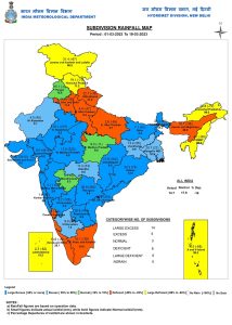 Sub-division wise seasonal pre monsoon rainfall in India so far in the month of March, 2023[/caption] Current synoptic features influencing weather in India as on 19 March: • The Western Disturbance as a cyclonic circulation over east Iran and adjoining Afghanistan now lies over Afghanistan and neighbourhood at 5.8 km above mean sea level. • The trough in middle and upper tropospheric westerlies with its axis 5.8 km above mean sea level roughly along Long. 78°E to the north of Lat.. 22°N persists. • The cyclonic circulation over East Rajasthan & adjoining West Madhya Pradesh extending up to 1.5 km above mean sea level persists. •The trough from the above cyclonic circulation over East Rajasthan & adjoining West Madhya Pradesh to Northwest Bay of Bengal across north Chhattisgarh, Jharkhand & Gangetic West Bengal at 0.9 km above mean sea level persists. • The cyclonic circulation over West Rajasthan & neighbourhood at 1.5 km above mean sea level persists. • The trough from north Punjab to the above cyclonic circulation over West Rajasthan & neighbourhood at 1.5 km above mean sea level persists. • The trough/wind discontinuity from South Interior Karnataka to Jharkhand from South Interior Karnataka to west Vidarbha across North Interior Karnataka & Marathwada at 0.9 km above mean sea level persists. The upcoming week is all set to start with active weather conditions over north, east and central India as the severe thunderstorms are expected in Punjab, Haryana, Delhi NCR, Uttar Pradesh, Jharkhand, Bihar, Chhattisgarh, Madhya Pradesh, Odisha, West Bengal on Monday while the rainfall activities will suddenly decrease in peninsula and West India this week as the lower level wind discontinuity will fade away. The weather conditions will improve slightly on 21st and 22nd March with reduction in rainfall activities but immediately another pair of strong Western Disturbance along with the cyclonic circulation will hit North India on 23rd and 24th March. Under the influence of weather systems another round of widespread rains will impact Rajasthan, Haryana, Delhi NCR, Punjab and Uttar Pradesh, severe weather in terms of moderate to heavy rains, lightning strikes, loud thundering, strong wind gust up to 40-50 km/h and hailstorms are predicted during the spell. During 23 to 25 March moderate to heavy rains and hailstorms are likely in lower and mid ranges of Himalayas in Kashmir, Himachal Pradesh and Uttarakhand with possible fresh round of snowfall over the higher reaches. Expected precipitation accumulation in the states till 25 March: Jammu Kashmir: 70 mm Himachal Pradesh: 60 mm Punjab: 50 mm Haryana: 50 mm Delhi NCR: 40 mm Uttarakhand: 40 mm Uttar Pradesh: 40 mm Rajasthan: 30 mm Bihar: 30 mm Jharkhand: 20 mm West Bengal: 20 mm Odisha: 20 mm Chhattisgarh: 10 mm Madhya Pradesh: 10 mm Gujarat: 10 mm Impact of unseasonal rains on the temperature? Maximum temperatures have been fairly below normal in the past 3-4 days across most parts of India. Day temperatures are expected in the range of 20 to 26°c in plains of north India on Monday and later in the week, this is likely to be 5 to 12°c below normal at most stations. The author, better known as the Rohtak Weatherman, interprets and explains complex weather patterns. His impact-based forecasts @navdeepdahiya55 are very popular in north India. Read all the
Latest News ,
Trending News ,
Cricket News ,
Bollywood News , India News and
Entertainment News here. Follow us on
Facebook,
Twitter and
Instagram.
Sub-division wise seasonal pre monsoon rainfall in India so far in the month of March, 2023[/caption] Current synoptic features influencing weather in India as on 19 March: • The Western Disturbance as a cyclonic circulation over east Iran and adjoining Afghanistan now lies over Afghanistan and neighbourhood at 5.8 km above mean sea level. • The trough in middle and upper tropospheric westerlies with its axis 5.8 km above mean sea level roughly along Long. 78°E to the north of Lat.. 22°N persists. • The cyclonic circulation over East Rajasthan & adjoining West Madhya Pradesh extending up to 1.5 km above mean sea level persists. •The trough from the above cyclonic circulation over East Rajasthan & adjoining West Madhya Pradesh to Northwest Bay of Bengal across north Chhattisgarh, Jharkhand & Gangetic West Bengal at 0.9 km above mean sea level persists. • The cyclonic circulation over West Rajasthan & neighbourhood at 1.5 km above mean sea level persists. • The trough from north Punjab to the above cyclonic circulation over West Rajasthan & neighbourhood at 1.5 km above mean sea level persists. • The trough/wind discontinuity from South Interior Karnataka to Jharkhand from South Interior Karnataka to west Vidarbha across North Interior Karnataka & Marathwada at 0.9 km above mean sea level persists. The upcoming week is all set to start with active weather conditions over north, east and central India as the severe thunderstorms are expected in Punjab, Haryana, Delhi NCR, Uttar Pradesh, Jharkhand, Bihar, Chhattisgarh, Madhya Pradesh, Odisha, West Bengal on Monday while the rainfall activities will suddenly decrease in peninsula and West India this week as the lower level wind discontinuity will fade away. The weather conditions will improve slightly on 21st and 22nd March with reduction in rainfall activities but immediately another pair of strong Western Disturbance along with the cyclonic circulation will hit North India on 23rd and 24th March. Under the influence of weather systems another round of widespread rains will impact Rajasthan, Haryana, Delhi NCR, Punjab and Uttar Pradesh, severe weather in terms of moderate to heavy rains, lightning strikes, loud thundering, strong wind gust up to 40-50 km/h and hailstorms are predicted during the spell. During 23 to 25 March moderate to heavy rains and hailstorms are likely in lower and mid ranges of Himalayas in Kashmir, Himachal Pradesh and Uttarakhand with possible fresh round of snowfall over the higher reaches. Expected precipitation accumulation in the states till 25 March: Jammu Kashmir: 70 mm Himachal Pradesh: 60 mm Punjab: 50 mm Haryana: 50 mm Delhi NCR: 40 mm Uttarakhand: 40 mm Uttar Pradesh: 40 mm Rajasthan: 30 mm Bihar: 30 mm Jharkhand: 20 mm West Bengal: 20 mm Odisha: 20 mm Chhattisgarh: 10 mm Madhya Pradesh: 10 mm Gujarat: 10 mm Impact of unseasonal rains on the temperature? Maximum temperatures have been fairly below normal in the past 3-4 days across most parts of India. Day temperatures are expected in the range of 20 to 26°c in plains of north India on Monday and later in the week, this is likely to be 5 to 12°c below normal at most stations. The author, better known as the Rohtak Weatherman, interprets and explains complex weather patterns. His impact-based forecasts @navdeepdahiya55 are very popular in north India. Read all the
Latest News ,
Trending News ,
Cricket News ,
Bollywood News , India News and
Entertainment News here. Follow us on
Facebook,
Twitter and
Instagram.
The upcoming week is all set to start with active weather conditions over north, east, and central India as severe thunderstorms are expected in Punjab, Haryana, Delhi NCR, Uttar Pradesh, Jharkhand, Bihar, Chhattisgarh, Madhya Pradesh, Odisha, and West Bengal on Monday
Advertisement
End of Article

 "Russian drones over Poland: Trump’s tepid reaction a wake-up call for Nato?")
 "As Russia pushes east, Ukraine faces mounting pressure to defend its heartland")
 "Why Mossad was not on board with Israel’s strike on Hamas in Qatar")
 "Turkey: Erdogan's police arrest opposition mayor Hasan Mutlu, dozens officials in corruption probe")


