 "Weather report: Western disturbances to take on 'October heat' in north India")
The southwest monsoon bid adieu to about 50 per cent of India last week. Mumbai, Pune, Delhi NCR, Ahmedabad, Jaipur, Bhopal, Lucknow, and Chandigarh are some of the major cities from which monsoon withdrawal has been declared until 8 October 2023. This season was unique in itself. It started with a cloudburst, and record-breaking rains in Himachal Pradesh and Uttarakhand caused flash floods. One of the major disasters of this century was observed in the western Himalayas. Now, at the end of the season, another low-pressure area stuck over Sub-Himalayan West Bengal wrecked havoc in Sikkim, parts of Bengal, and Bihar. Extreme rainfall amid a cloudburst led to flash floods and landslides in various parts of Sikkim, causing extensive damage to life and property in the region from 3 October to 6 October. In the span of 24 hours on 3 October, Barisha in Paschim Medinipur recorded a massive 522.0 mm rainfall; this is about 80 per cent of Delhi’s seasonal rains falling in a single day. Following Barisha, Sabang recorded 438.5 mm, Amgachia 440.8 mm, and Panskura 242.3 mm, respectively, on the same day. Monsoon is on the top gear before it exits from northeast India, Cherrapunji in Meghalaya recorded 189 mm rains 8:30 am on Sunday morning, and about 585 mm is experienced in the span of the last 72 hours. October heat develops in various parts of India The sinking dry and hot air from the anti-cyclonic circulation over Gujarat towards the western Himalayas, Punjab, Haryana, Delhi NCR, Rajasthan, Uttar Pradesh, Madhya Pradesh, Maharashtra resulted in rise in day temperatures across the region and October heat has settled in the various parts as soon as monsoon withdrawal. Bhuntar in Himachal broke its monthly record for the second time in the past week by witnessing a maximum temperature of 33.6°C on 7 October, the previous record was of 33.4°C from 2 October 2020. Dharamshala with 31.0°C matched its October all time high record, Capital city Shimla sizzled at 25.6°c on Saturday afternoon. Hot Sunday afternoon across major metros other cities in the country, maximum temperatures: New Delhi: 36.5°C Chandigarh: 35.7°C Jaisalmer: 38.5°C Jaipur: 36.0°C Lucknow: 35.8°C Bhopal: 35.2°C Ahmedabad: 35.2°C Chennai: 35.0°C Pune: 34.1°C Hyderabad: 33.6°C Mumbai: 33.5°C [caption id=“attachment_13221112” align=“alignnone” width=“857”]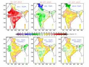 Maximum temperature anomaly was higher than normal in most parts of India on the weekend, anomaly was exceptionally high for minimum temperature in north India[/caption] Current status of monsoon withdrawal as on 9 October 2023 • The line of withdrawal of the southwest monsoon continues to pass through 28.6°N/80.6°E, Lucknow, Satna, Nagpur, Parbhani, Pune, Alibag and 18.9°N/70.0°E. • Conditions are favourable for further withdrawal of southwest monsoon from remaining parts of East Uttar Pradesh, East Madhya Pradesh; some parts of Bihar, Jharkhand, Gangetic West Bengal, Odisha, Chhattisgarh, Telangana and some more parts of Maharashtra and Central Arabian Sea during next two days. [caption id=“attachment_13221122” align=“alignnone” width=“725”]
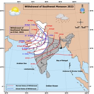 Map indicates the status of the withdrawal of southwest monsoon 2023 from India[/caption] Current synoptic weather features influencing weather in India as on 9 October The cyclonic circulation over north-coastal Andhra Pradesh and neighbourhoods between 3.1 km and 4.5 km above mean sea level persists. The cyclonic circulation over Lakshadweep and the neighbourhood at 1.5 km above mean sea level persists. The north-south trough from Sikkim to north-coastal Odisha across central parts of Bangladesh, extending up to 3.1 km above mean sea level, persists. The trough from central parts of Chhattisgarh to south Tamil Nadu across Telangana and interior Karnataka at 0.9 km above mean sea level persists. The cyclonic circulation over Tamil Nadu and the neighbourhood at 4.5 km above mean sea level persists. The Western Disturbance as a trough in westerlies with its axis at 4.5 km above mean sea level roughly along Long. 70°E to the north of Lat. 32°N persists. All India weather forecast till 15 October 2023 The withdrawal of southwest monsoon is expected from most parts of Bihar, Jharkhand, Chhattisgarh, West Bengal, Telangana, Maharashtra, Odisha and some parts of northeast India within this week as rains subsides completely, dry and hot conditions are ahead for the states in the upcoming week. [caption id=“attachment_13221142” align=“alignnone” width=“454”]
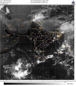 Satellite imagery from 9 October i.e. Monday morning shows clear skies across India indicates quick wrap up of monsoon from rest parts of India in the coming days[/caption] Pre-northeast monsoon thunderstorms to peak in southern peninsula Two cyclonic circulations over south Andhra Pradesh and Tamil Nadu have created lower level wind discontinuity in the states, the northeast monsoon season is yet to begin as conditions are not favourable for another one week, but LWD generated moisture in the atmosphere will trigger intense thunderstorms in various parts of interiors of Tamil Nadu, Kerala, the southern interiors of Karnataka including Bangalore and southern Andhra Pradesh to experience heavy rains, lightning strikes, gusty winds during the evening and night hours almost on a daily basis during the period of 9 to15 October, this spell is expected to be the peak of pre-northeast monsoon rains in south before the season starts in the last week of October. Western disturbances to take on October heat in north India Soaring temperatures in western Himalayas are reaching record levels, northern plains experiencing hot weather conditions during the day time as maximum temperatures at various cities are recorded between 35°C and 39°C, It is likely to be on similar levels for next few days especially in the beginning of the week and would start reducing Thursday onwards. Autumn’s first active western disturbance is anticipated to impact the Himalayas on 14 October, at the same time a cyclonic circulation will induce over Punjab the combination of the weather stations will result in first and early heavy snowfall over various upper reaches of Kashmir, Ladakh, Himachal Pradesh and Uttarakhand during 14 to 16 October, rains, hailstorm and thunderstorms in lower elevation hills. (Dipping jet streams and developing circulation on lower wind levels around 14 October indicates active western disturbance) Induced cyclonic circulation will start producing thunder clouds in the plains starting from 14 October till 16 October. Scattered light to moderate rains, thunderstorms, and hailstorms will occur in parts of Punjab, Rajasthan, Haryana, Delhi NCR, and Uttar Pradesh. This spell of rain might cause some damage to the standing kharif crop, but this will result in reducing the pollution levels, which generally start to peak from mid-October onwards. As a post-factor, temperatures will start reducing across the plains, with a minimum below 15°C and a maximum below 30°C, which is the perfect temperature range to call it the early autumn season across north India. Nevertheless, back-to-back western disturbances are predicted till October end, hence there will be more wet spells over the Himalayas and plains. There is some possibility that winter-level temperatures will range before Diwali this time if the frequency of western disturbances remains on the higher side.
The writer, better known as the Rohtak Weatherman, interprets and explains complex weather patterns. His impact-based forecasts @navdeepdahiya55 are very popular in north India. Views expressed in the above piece are personal and solely that of the author. They do not necessarily reflect Firstpost_’s views._ Read all the Latest News , Trending News , Cricket News , Bollywood News , India News and Entertainment News here. Follow us on Facebook , Twitter and Instagram .