
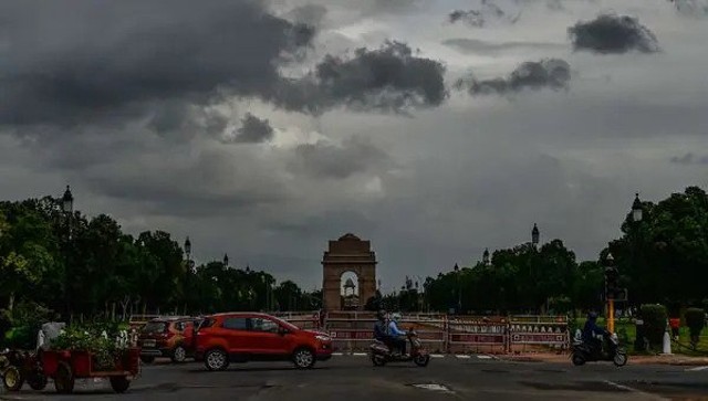
 "Weather report: Western disturbance to hit Delhi, north India; pre-monsoon showers expected down south")
October heat was at its peak in the past week. High pressure over the subcontinent was supported by the anti-cyclonic circulation over Pakistan, and adjoining Gujarat kept pushing dry and hot winds across north, west, and central India. Eventually, temperature had to rise as cloud cover had gone as monsoons withdrawn from most parts of central and east India before time. Normally, when monsoon withdrawal takes place around mid-October, regions, especially around Konkan and West Central India, escape the October heat; however, this time there are no other options as the monsoon decided to exit the region in the first week of October itself. Maximum temperature in Mumbai, suburbs and Konkan region on 13 October: Thane: 37.9°C Mumbra: 37.5°C Kalyan: 37.4°C Badlapur: 37.3°C Panvel: 37°C Mulund: 36.9°C Vidyavihar: 36.7°C Mira Road: 36.4°C Navi Mumbai: 36.3°C Dapoli: 36.2°C Dahanu: 35.3°C Mumbai: 35.1°C [caption id=“attachment_13253382” align=“alignnone” width=“785”] Above normal temperature anomaly over most parts of the country during the month of October so far[/caption] Along with the heat, pollution is another parameter which has increased gradually in the past week, New Delhi, Mumbai, Ahmedabad, Chandigarh, Lucknow amongst the major cities to experience an air quality index in poor category for the first time this year in the last few days. According to the AQI scale, air quality falling between 0 and 50 is classified as “good”, 51 to 100 as “satisfactory”, 101 to 200 as “moderate”, 201 to 300 as “poor”, 301 to 400 as “very poor”, and 401 to 450 as “severe”. The term “severe” is used when the AQI surpasses 450. When most parts of north, east, central and west India saw dry weather conditions, southern parts of the country rejoiced in rains in the past week, parts of Kerala and Tamil Nadu witnessed heavy to extremely heavy pre-northeast monsoon showers. Vellayani: 216 mm Thiruvananthapuram: 211 mm Ponmudi: 208 mm Varkala; 163 mm Thiruvalla: 152 mm Alappuzha: 131 mm Palakkad: 124 mm Kochi: 104 mm Under the influence of western disturbance various parts of Kashmir, Ladakh, Himachal Pradesh and Uttarakhand experienced the first event of moderate snowfall over the Himalayan peaks on the weekend. In plains parts of Punjab, Chandigarh received light to moderate showers on Saturday and early on Sunday. The Northeast monsoon/post-monsoon season has completed its first fortnight, and actual rainfall so far in the period of 1 to 15 October stands at 38.9 mm against the normal of 46.1 mm. The departure from normal currently stands at -16 per cent. Subdivision wise seasonal rains till 15 October: • Southern peninsula: Actual 38.8 mm against the average of 79.1 mm, -51 per cent departure from normal. • East and northeast India: Actual 128.0 mm against the average of 82.7 mm, +55 per cent departure from normal. • Northwest India: Actual 11.9 mm against the average of 13.8 mm, -14 per cent departure from normal. • Central India: Actual 21.4 mm against the average of 38.9 mm, -45 per cent departure from normal. [caption id=“attachment_13253432” align=“alignnone” width=“698”]
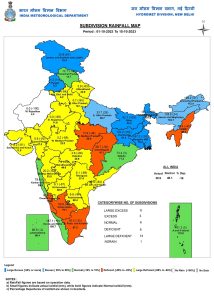 Subdivision wise seasonal rainfall in the first 15 days of October, 2023[/caption] Current status of monsoon withdrawal as on 15 October: • The line of withdrawal of southwest monsoon continues to pass through Forbesganj, Malda, 24.0°N/89.0°E, 20.0°N/89.0°E, Visakhapatnam, Nalgonda, Raichur, Vengurla and 16.0°N/70.0°E. • Southwest monsoon is expected to withdraw from remaining parts of northeast India in the next 2-3 days hence the withdrawal of seasonal rains pan India will complete its course. [caption id=“attachment_13253472” align=“alignnone” width=“739”]
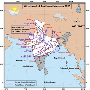 Status of monsoon withdrawal as on 15 October 2023[/caption] Current synoptic weather features influencing weather in India as of 15 October 2023: A western disturbance as a cyclonic circulation over Jammu division and adjoining Pakistan at 3.1 km above mean sea level with a trough aloft in middle tropospheric westerlies with its axis at 5.8 km above mean sea level now runs roughly along Long. 70°E to the north of Lat. 30°N. The induced cyclonic circulation over Punjab and the neighbourhood at 0.9 km above mean sea level persists. Another western disturbance as a trough in westerlies between 3.1 km and 4.5 km above mean sea level now runs roughly along Long 60°E to the north of Lat 26°N. A cyclonic circulation over the Lakshadweep area and adjoining southeast Arabian Sea and Kerala coast, extending up to 3.1 km above mean sea level, persists. Under its influence, a low-pressure area is likely to develop over the southeast and adjoining east-central Arabian Sea around 17 October. It is likely to move west-northwestward and intensify further during the subsequent 48 hours. A trough from east Bihar to south Bangladesh across West Bengal, extending up to 1.5 km above mean sea level, persists. A cyclonic circulation over coastal Tamil Nadu and its neighbourhoods, extending up to 2.1 km above mean sea level, persists. All India weather forecast till 22 October 2023: Western disturbance to drench entire north India Most parts of central and east India will continue with their dry weather streak this week as well; however, a strong western disturbance will affect most states in north India on 16 and 17 October. Widespread rains, thundershowers, gusty winds, hailstorms, and lightning strikes are very likely in Punjab, Haryana, Delhi NCR, north and central Rajasthan, and west and central Uttar Pradesh, starting Monday morning until Tuesday night. Enhanced clouding will lead to a significant drop in day temperature, and maximum temperatures will settle below 25°C in most parts of Punjab; it is likely below 28°C in Delhi NCR, Haryana, and parts of Uttar Pradesh on both days. This system will bring in a temporary winter chill in the air and subside air pollution for a few days. (Satellite imagery shows active western disturbance affecting north India on the morning of 16 October) While it’s rain and hailstorm in the plains, Himalayas brace for a proper snowfall event Monday onwards, this western disturbance is properly fueled with moist air from Punjab based cyclonic circulation this will result in Moderate to heavy snowfall in Kashmir, Ladakh, Himachal Pradesh and Uttarakhand, most hill stations and tops above 3000 metres of elevation to experience snowfall in this system. Lower Himalayan ranges to experience Moderate to heavy rains, hails and thunderstorms activities. After the passage of the western disturbance from Wednesday onwards minimum temperatures will start dipping to sub zero levels in some parts of Himalayas and below 15°C in Punjab, Haryana, north Rajasthan, west Uttar Pradesh and Delhi NCR as now winds from the northwest to make the nights go cool and days pleasant for the rest of the week. More pre-monsoon showers in south, further wait for northeast monsoon The northeast winds are yet to settle in Tamil Nadu therefore monsoon is still 10 days away however lower level wind discontinuity continue to prevail in parts of Kerala and west Tamil Nadu this will ensure good spells of pre-monsoon thunderstorms in many parts of south and west Tamil Nadu along with parts of south Karnataka and Kerala, parts of coastal Tamil including Chennai will experience isolated rain in spread and also the impact will be limited to a few days only, the wait will continue to increase for proper heavy onset of the northeast monsoon. Brewing cyclonic storm Bay of Bengal and Arabian sea individually are likely to see formation of low pressure area early this week and are anticipated to go under rapid intensification with more weather dynamics are coming in the picture it’s highly uncertain to call whether it will turn out to be cyclonic storm or not but for sure there is potential as post monsoon season is know for strong cyclones in Indian ocean, both the synoptic systems are expected to reach their peak intensity by weekend or early next week but as per the current weather model guidance there tracks are keeping them away from both east and west coast of India, nevertheless the dynamics will change and things shape up quickly after the genesis of low pressure area in seas and lot more calculations would happen considering sea surface temperature, upper level winds or Jet streams, wind shear will define the track of the weather systems there will be better clarity by mid week. The writer, better known as the Rohtak Weatherman, interprets and explains complex weather patterns. His impact-based forecasts @navdeepdahiya55 are very popular in north India. Views expressed in the above piece are personal and solely that of the author. They do not necessarily reflect Firstpost_’s views._ Read all the
Latest News ,
Trending News ,
Cricket News ,
Bollywood News , India News and
Entertainment News here. Follow us on
Facebook,
Twitter and
Instagram.
Status of monsoon withdrawal as on 15 October 2023[/caption] Current synoptic weather features influencing weather in India as of 15 October 2023: A western disturbance as a cyclonic circulation over Jammu division and adjoining Pakistan at 3.1 km above mean sea level with a trough aloft in middle tropospheric westerlies with its axis at 5.8 km above mean sea level now runs roughly along Long. 70°E to the north of Lat. 30°N. The induced cyclonic circulation over Punjab and the neighbourhood at 0.9 km above mean sea level persists. Another western disturbance as a trough in westerlies between 3.1 km and 4.5 km above mean sea level now runs roughly along Long 60°E to the north of Lat 26°N. A cyclonic circulation over the Lakshadweep area and adjoining southeast Arabian Sea and Kerala coast, extending up to 3.1 km above mean sea level, persists. Under its influence, a low-pressure area is likely to develop over the southeast and adjoining east-central Arabian Sea around 17 October. It is likely to move west-northwestward and intensify further during the subsequent 48 hours. A trough from east Bihar to south Bangladesh across West Bengal, extending up to 1.5 km above mean sea level, persists. A cyclonic circulation over coastal Tamil Nadu and its neighbourhoods, extending up to 2.1 km above mean sea level, persists. All India weather forecast till 22 October 2023: Western disturbance to drench entire north India Most parts of central and east India will continue with their dry weather streak this week as well; however, a strong western disturbance will affect most states in north India on 16 and 17 October. Widespread rains, thundershowers, gusty winds, hailstorms, and lightning strikes are very likely in Punjab, Haryana, Delhi NCR, north and central Rajasthan, and west and central Uttar Pradesh, starting Monday morning until Tuesday night. Enhanced clouding will lead to a significant drop in day temperature, and maximum temperatures will settle below 25°C in most parts of Punjab; it is likely below 28°C in Delhi NCR, Haryana, and parts of Uttar Pradesh on both days. This system will bring in a temporary winter chill in the air and subside air pollution for a few days. (Satellite imagery shows active western disturbance affecting north India on the morning of 16 October) While it’s rain and hailstorm in the plains, Himalayas brace for a proper snowfall event Monday onwards, this western disturbance is properly fueled with moist air from Punjab based cyclonic circulation this will result in Moderate to heavy snowfall in Kashmir, Ladakh, Himachal Pradesh and Uttarakhand, most hill stations and tops above 3000 metres of elevation to experience snowfall in this system. Lower Himalayan ranges to experience Moderate to heavy rains, hails and thunderstorms activities. After the passage of the western disturbance from Wednesday onwards minimum temperatures will start dipping to sub zero levels in some parts of Himalayas and below 15°C in Punjab, Haryana, north Rajasthan, west Uttar Pradesh and Delhi NCR as now winds from the northwest to make the nights go cool and days pleasant for the rest of the week. More pre-monsoon showers in south, further wait for northeast monsoon The northeast winds are yet to settle in Tamil Nadu therefore monsoon is still 10 days away however lower level wind discontinuity continue to prevail in parts of Kerala and west Tamil Nadu this will ensure good spells of pre-monsoon thunderstorms in many parts of south and west Tamil Nadu along with parts of south Karnataka and Kerala, parts of coastal Tamil including Chennai will experience isolated rain in spread and also the impact will be limited to a few days only, the wait will continue to increase for proper heavy onset of the northeast monsoon. Brewing cyclonic storm Bay of Bengal and Arabian sea individually are likely to see formation of low pressure area early this week and are anticipated to go under rapid intensification with more weather dynamics are coming in the picture it’s highly uncertain to call whether it will turn out to be cyclonic storm or not but for sure there is potential as post monsoon season is know for strong cyclones in Indian ocean, both the synoptic systems are expected to reach their peak intensity by weekend or early next week but as per the current weather model guidance there tracks are keeping them away from both east and west coast of India, nevertheless the dynamics will change and things shape up quickly after the genesis of low pressure area in seas and lot more calculations would happen considering sea surface temperature, upper level winds or Jet streams, wind shear will define the track of the weather systems there will be better clarity by mid week. The writer, better known as the Rohtak Weatherman, interprets and explains complex weather patterns. His impact-based forecasts @navdeepdahiya55 are very popular in north India. Views expressed in the above piece are personal and solely that of the author. They do not necessarily reflect Firstpost_’s views._ Read all the
Latest News ,
Trending News ,
Cricket News ,
Bollywood News , India News and
Entertainment News here. Follow us on
Facebook,
Twitter and
Instagram.
Most parts of central and east India will continue with their dry weather streak this week as well; however, a strong western disturbance will affect most states in north India on 16 and 17 October
Advertisement
End of Article

 "Russian drones over Poland: Trump’s tepid reaction a wake-up call for Nato?")
 "As Russia pushes east, Ukraine faces mounting pressure to defend its heartland")
 "Why Mossad was not on board with Israel’s strike on Hamas in Qatar")
 "Turkey: Erdogan's police arrest opposition mayor Hasan Mutlu, dozens officials in corruption probe")


