
 "Weather Report: Upcoming week is likely to end with good rains across India")
Monsoon continues to maintain the pace that was picked in the last week of June. The southwest monsoon has further advanced into the remaining parts of Rajasthan, Haryana and Punjab on 2 July 2023. Thus, it has covered the entire country today, the 2 July 2023, against the normal date of 8 July (6 days before the normal date of covering the entire India). [caption id=“attachment_12817752” align=“alignnone” width=“542”] The south west monsoon has covered entire country on 2nd July as per IMD[/caption] Monsoon made a staggering revival in the past week and drenched most parts of Bihar, Uttar Pradesh, Delhi NCR, Rajasthan, Madhya Pradesh, Gujarat and Konkan region of Maharashtra with good rains. Visavadar in Junagadh district has recorded a whopping 831mm rainfall in the span of the last 4 days which is more than its seasonal average rainfall created flood like situation in the interiors and Saurashtra region of Gujarat. The long awaited heavy monsoon showers on the Ghat section of Maharashtra was seen over the last week, Matheran in Raigad district recorded heavy showers on a daily basis: 1 July: 185 mm 30 June: 100 mm 29 June: 94 mm 28 June: 56 mm 27 June: 120 mm 26 June: 92 mm 25 June: 143 mm Total Rainfall recorded during the month of June 2023 at the wettest places in the world - 1) Mawsynram: 2678.0 mm 2) Cherrapunji (Main): 2575.0 mm 3) Cherrapunji (RKM): 2467.4 mm The rains in the north east are back on track, Cherrapunji opened its July rain quota with double century recorded 220mm rainfall during the span of 24 hours ending 8:30 AM on 1 July 2023. The Dynamics of monsoon continue to surprise many, the contrasts in rainfall patterns were observed in Himachal Pradesh and Uttarakhand hill stations. Shimla recorded 324.9mm rainfall during the month of June 2023, becoming the second highest monthly rainfall at least in the last 20 years for the capital of Himachal Pradesh. The all time high monthly record for June is 570.2 mm in 2008. While Mukteshwar in Uttarakhand had another poor June in a row, Mukteshwar recorded just 32.6 mm of rain in June 2023, while the driest ever is 17.8 mm from June 1935. Rainfall in Mukteshwar over the month of June in the past 8 years 2023: 32.6 mm 2022: 63.3 mm 2021: 349.1 mm 2020: 109.4 mm 2019: 225.9 mm 2018: 209.8 mm 2017: 172.0 mm 2016: 74.7 mm 2015: 218.8 mm [caption id=“attachment_12817762” align=“alignnone” width=“555”]
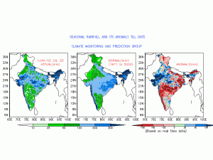 Spatial rainfall in June 2023, on a contrast it rained more in the areas where the rains are usually low[/caption] June ended on a good rainfall note in the country’s Capital as well, base observatory Safdarjung received 101.7 mm rainfall across the month which is the highest after June 2017. On 30 June first monsoon drenched the east Uttar Pradesh and Bihar with much awaited rain and ended the prolonged spell of sultry weather, first century of the monsoon was witnessed in Bihar’s Capital Patna with a 143 mm rainfall in the span of 24 hours. Good rainfall figures from other parts of Poorvanchal on 30 June 2023: Bhagalpur: 87 mm Muzaffarpur: 85 mm Prayagraj: 68 mm Varanasi: 62 mm Fursatganj: 42 mm Gorakhpur: 42 mm Meanwhile the good rains have brought smiles on the faces of many farmers, still there are some regions in the country struggling to achieve average rainfall. At the end of June the worst performing subdivisions in the ongoing monsoon are (rain in percentage departure from normal): 1. Marathwada: -69 per cent 2. Kerala: -60 per cent 3. South interior Karnataka: -56 per cent 4. North Interior Karnataka: -54 per cent 5. Madhya Maharashtra: -51 per cent 6. Telangana: -50 per cent In the period of 1 June till 2 July, India as a whole has received 136.5 mm rainfall against the normal of 157.7 mm, departure from normal stands at -13 per cent compared to week on week of -23 per cent. Subdivision wise seasonal rainfall till 2 July 2023 • Southern Peninsula: Actual 84.9 mm against the average of 154.9 mm, -45 per cent departure from normal. • East and North East India: Actual 253.4 mm against the average of 315.8 mm, -20 per cent departure from normal. • North West India: Actual 101.9 mm against the average of 72.9 mm, +40 per cent departure from normal. • Central India: Actual 142.7 mm against the average of 161.9 mm, -12 per cent departure from normal. [caption id=“attachment_12817772” align=“alignnone” width=“561”]
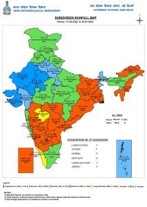 Subdivision wise seasonal rainfall in India during the period of 1st June till 2 July 2023[/caption] Current synoptic weather features influencing weather in India as 2 July 2023 • The monsoon trough at mean sea level passes through Bikaner, Dausa, Gwalior, Sidhi, Ambikapur, Balasore and hence eastwards to Northwest Bay of Bengal. • The cyclonic circulation over northwest Uttar Pradesh and neighbourhood now lies over central parts of Uttar Pradesh and extends upto 5.8 km above mean sea level. • The off-shore trough at mean sea level now runs from south Maharashtra coast to Kerala coast. • The cyclonic circulation over central parts of south Bay of Bengal and adjoining central Bay of Bengal now lies over central parts of Southwest Bay of Bengal between 4.5 and 5.8 km above mean sea level. • A cyclonic circulation lies over north Andaman Sea between 1.5 & 5.8 km above mean sea level. • A cyclonic circulation lies over Sub-Himalayan West Bengal & Sikkim at 3.1 km above mean sea level. • The Western Disturbance is a trough in middle tropospheric westerlies with its axis at 5.8 km above mean sea level roughly along Long. 76°E to the north of 30°N has moved away. • The trough from the above cyclonic circulation over northwest Uttar Pradesh and neighbourhood to northeast Arabian Sea across east Rajasthan and Gujarat between 3.1 and 5.8 km above mean sea level has become less marked. All India weather forecast till 9 July 2023 It is likely to be another week with very active monsoon conditions across the country as a low pressure area from the Bay of Bengal will travel inland and keep the monsoon axis active over central and north India. Under the influence of the weather system widespread heavy to very heavy rains are expected in Andhra Pradesh, Telangana, Maharashtra, Kerala, Karnataka during 3 to 6 July, finally the driest subdivisions of the country will experience good monsoon surge. As soon the system move inland and establish it over Madhya Pradesh by 5th July, fairly widespread to widespread moderate to heavy rains will occur in Chhattisgarh, Madhya Pradesh, Gujarat, Bihar, Uttar Pradesh, Delhi NCR, Punjab, Rajasthan, Haryana, Uttarakhand, Himachal Pradesh and Jammu division during 5 to 9 July. Overall on pan India the upcoming week is likely to end with normal to above normal rains with high probability of excessive rains in Konkan, Ghat section along with central heartland of the country, this will boost the agriculture practices such as sowing of kharif crops which was delayed due to delayed monsoon, also statistically the rainfall deficiencies will head into normal category just before the first break in monsoon conditions which is anticipated in the second half of July. The author, better known as the Rohtak Weatherman, interprets and explains complex weather patterns. His impact-based forecasts @navdeepdahiya55 are very popular in north India. Read all the
Latest News ,
Trending News ,
Cricket News ,
Bollywood News , India News and
Entertainment News here. Follow us on
Facebook,
Twitter and
Instagram.
Subdivision wise seasonal rainfall in India during the period of 1st June till 2 July 2023[/caption] Current synoptic weather features influencing weather in India as 2 July 2023 • The monsoon trough at mean sea level passes through Bikaner, Dausa, Gwalior, Sidhi, Ambikapur, Balasore and hence eastwards to Northwest Bay of Bengal. • The cyclonic circulation over northwest Uttar Pradesh and neighbourhood now lies over central parts of Uttar Pradesh and extends upto 5.8 km above mean sea level. • The off-shore trough at mean sea level now runs from south Maharashtra coast to Kerala coast. • The cyclonic circulation over central parts of south Bay of Bengal and adjoining central Bay of Bengal now lies over central parts of Southwest Bay of Bengal between 4.5 and 5.8 km above mean sea level. • A cyclonic circulation lies over north Andaman Sea between 1.5 & 5.8 km above mean sea level. • A cyclonic circulation lies over Sub-Himalayan West Bengal & Sikkim at 3.1 km above mean sea level. • The Western Disturbance is a trough in middle tropospheric westerlies with its axis at 5.8 km above mean sea level roughly along Long. 76°E to the north of 30°N has moved away. • The trough from the above cyclonic circulation over northwest Uttar Pradesh and neighbourhood to northeast Arabian Sea across east Rajasthan and Gujarat between 3.1 and 5.8 km above mean sea level has become less marked. All India weather forecast till 9 July 2023 It is likely to be another week with very active monsoon conditions across the country as a low pressure area from the Bay of Bengal will travel inland and keep the monsoon axis active over central and north India. Under the influence of the weather system widespread heavy to very heavy rains are expected in Andhra Pradesh, Telangana, Maharashtra, Kerala, Karnataka during 3 to 6 July, finally the driest subdivisions of the country will experience good monsoon surge. As soon the system move inland and establish it over Madhya Pradesh by 5th July, fairly widespread to widespread moderate to heavy rains will occur in Chhattisgarh, Madhya Pradesh, Gujarat, Bihar, Uttar Pradesh, Delhi NCR, Punjab, Rajasthan, Haryana, Uttarakhand, Himachal Pradesh and Jammu division during 5 to 9 July. Overall on pan India the upcoming week is likely to end with normal to above normal rains with high probability of excessive rains in Konkan, Ghat section along with central heartland of the country, this will boost the agriculture practices such as sowing of kharif crops which was delayed due to delayed monsoon, also statistically the rainfall deficiencies will head into normal category just before the first break in monsoon conditions which is anticipated in the second half of July. The author, better known as the Rohtak Weatherman, interprets and explains complex weather patterns. His impact-based forecasts @navdeepdahiya55 are very popular in north India. Read all the
Latest News ,
Trending News ,
Cricket News ,
Bollywood News , India News and
Entertainment News here. Follow us on
Facebook,
Twitter and
Instagram.
It is likely to be another week with very active monsoon conditions across the country as a low pressure area from the Bay of Bengal will travel inland and keep the monsoon axis active over central and north India
Advertisement
End of Article

 "Russian drones over Poland: Trump’s tepid reaction a wake-up call for Nato?")
 "As Russia pushes east, Ukraine faces mounting pressure to defend its heartland")
 "Why Mossad was not on board with Israel’s strike on Hamas in Qatar")
 "Turkey: Erdogan's police arrest opposition mayor Hasan Mutlu, dozens officials in corruption probe")


