Cyclone Mocha attained the category of “Super Cyclone” on Saturday night as the maximum wind gust reported by Joint Typhoon Warning Center as 150 Knots, a category 5 hurricane made the landfall near Sittwe in Myanmar on the Sunday afternoon, the tropical disturbance de-intensified to a lower category with maximum wind gusts of 130 to 135 Knots, the coast of Myanmar braced the monster with a maximum wind gust of 240 km/h and storm surge of at least 3 to 3.5 meters in height, a complete mayhem by the mother nature on the Mother’s Day. [caption id=“attachment_12596922” align=“alignnone” width=“572”]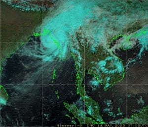 Satellite imagery of Cyclone Mocha during the landfall process[/caption] More facts about the cyclone Mocha: • It is the strongest cyclone ever formed in the pre-monsoon season in the entire north Indian Ocean (Arabian Sea and Bay of Bengal combined) in the satellite era since 1982 as per Joint Typhoon Warning Centre (JTWC), the highest winds reported by the system was 150 Knots tied with cyclone Fani. Strongest cyclones (wind speed in knots) in the North Indian Ocean (as per JTWC records) • Mocha (Bay of Bengal, 2023): 150 knots. • Amphan (Bay of Bengal, 2020): 145 Knots. • Gonu (Arabian sea, 2007): 145 knots. • 1999 super cyclone (Bay of Bengal): 140 knots. • Phailin (Bay of Bengal, 2013): 140 knots. • Kyarr (Arabiansea, 2019): 135 knots. • Tauktae (Arabian sea, 2021): 120 knots. • Mocha is only the fifth category 5 cyclone in the entire north Indian Ocean in the pre-monsoon season (April-June) since 1982. Out of these five Category 5 cyclones since 1982, four have formed since 2007. • In Bay of Bengal, this is the fourth category 5 during the pre-monsoon season cyclone since 1982, out of these four category 5 cyclones, three formed in bay since 2019 onwards, evident that cyclones are potentially stronger in the recent times under warmer sea conditions can be attributed to climate change. [caption id=“attachment_12596932” align=“alignnone” width=“595”]
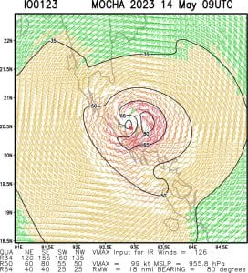 Sustained Eye wall of the cyclone Mocha even after making a landfall on the surface shows the strength of this tropical disturbance[/caption] As the cyclone pulled out all the moisture content from the atmosphere in the interiors of the country along with the formation of anti cyclonic circulation over arabian sea most parts in north, central and southern India baked in season’s first widespread Heatwave as maximum temperatures crossed 40°C mark for most stations while reported above 45°C at a few stations in Rajasthan, Haryana, Maharashtra, Madhya Pradesh this weekend. Top ten hottest stations in India on 13 May, Saturday: Jaisalmer: 46.0°c Khargone: 46.0°c Tonk: 45.8°c Barmer: 45.7°c Churu: 45.6°c Akola: 45.6°c Kota: 45.4°c Jhansi: 45.3°c Mahendragarh: 45.1°c Bikaner: 45.0°c The dry heat ensures major metro cities experience maximum temperatures above 40°C. On Wednesday Pune recorded 40.1°C while on Friday New Delhi settled with the maximum temperature of 42.5°C highest in this season so far. The Dry westerly winds prevailed over southern India on the weekend as Chennai crossed 40°C temperature mark for the first time in this season with a maximum temperature of 40.7°C, reported 3°C above normal. [caption id=“attachment_12596962” align=“alignnone” width=“594”]
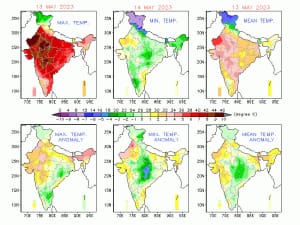 Bay brewed “Mocha” but India got baked in the heat wave as temperature anomaly is 4 to 5 degrees above normal at various parts[/caption] Past week has turned up to be relatively dry as action shifted to seas, in the pre-monsoon season far between 1 March till 14 May country as whole received a total of 112.5mm rainfall against the normal of 94.0 mm, departure from normal stands at +20 per cent, fell from +30 per cent reported last Sunday. Subdivision wise seasonal rainfall till 14 May: • Southern Peninsula: Actual 138.6 mm against the average of 78.6 mm, +76 per cent departure from normal. • East and North East India: Actual 165.9 mm against the average of 258.0 mm, -36 per cent departure from normal. • North West India: Actual 110.0 mm against the average of 95.2 mm, +16 per cent departure from normal. • Central India: Actual 74.2 mm against the average of 24.1 mm, +208 per cent departure from normal. [caption id=“attachment_12596972” align=“alignnone” width=“597”]
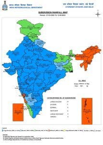 Pre-monsoon seasonal rains so far in India till 14th May[/caption] Current synoptic weather features influencing weather in India as on 14 May, 2023: • The Extremely Severe Cyclonic Storm “Mocha” (pronounced as “Mokha”) over Northeast Bay of Bengal moved north-northeast wards with a speed of 28 kmph during past 6 hours, crossed north Myanmar, southeast Bangladesh coasts between Kyaukpyu (Myanmar) and Cox’s Bazar (Bangladesh) close to north of Sittwe (Myanmar) near latitude 20.25°N and longitude 92.75°E as an Extremely Severe Cyclonic Storm with wind speed of 180-190 kmph gusting to 210 kmph during 12:30 to 14:30 hours IST on 14 May 2023. It lay centered at 14:30 hours IST of today the 14 May 2023 over coastal Myanmar near latitude 20.5°N and longitude 92.9°E, about 40 km north of Sittwe (Myanmar) and 145 km southeast of Cox’s Bazar (Bangladesh). The system is continuing the weakening trend since then. • The Western Disturbance as a trough in mid and upper tropospheric westerlies with its axis at 5.8 km above mean sea level roughly along Long. 71°E to the north of Lat. 32°N persists. • The cyclonic circulation over south Haryana and neighbourhood at 0.9 km above mean sea level persists. • A fresh Western Disturbance is likely to affect Northwest India from the night of 17 May, 2023. All India weather forecast till 20 May: Heat to persist along with the comeback of evening thunderstorms As the cyclone Mocha dissipates the moisture pull will take an exit and wind instability will re-structure in the interiors of India this will be further fueled by the approaching western disturbance over North India early next week. The day time weather is most likely to be dry and hot in Punjab, Haryana, Delhi NCR, Rajasthan, Uttar Pradesh, Gujarat, Maharashtra, Madhya Pradesh, Bihar, Jharkhand, Odisha, Chhattisgarh, Telangana, Andhra Pradesh with maximum temperatures in the range of 40 to 43°C, Heatwave conditions will prevail in some parts of Rajasthan, Haryana, Gujarat, Madhya Pradesh, Telangana, Andhra Pradesh as few pockets may experience maximum temperature around 45°C. Under the influence of western disturbance and lower level wind instability, weather patterns will change during the evening hours as convective clouds do form after hot afternoons, this will result in return of Isolated dust storms, short bursts of rains, hailstorm during 15 to 16th May in Rajasthan, Punjab, Haryana, Delhi NCR, Uttar Pradesh. The spread and intensity of rains will increase on 17 and 18 May with probable drop in temperatures by 3 to 5°C during Wednesday to Friday in north west India but Heatwave will return again by the weekend as dry conditions come back. Evening thunderstorms are predicted for parts of Bihar, Jharkhand, West Bengal, Odisha in this week commonly called as Kal Baisakhi. Meanwhile most parts in Gujarat, Maharashtra, Telangana, Andhra Pradesh, Tamil Nadu to experience a dry and hot week as no meaningful rains are predicted while parts of Kerala will continue to experience on and off pre monsoon rains. North East India’s dry run to end It has been a very poor pre-monsoon season in the seven sister states; the departure from normal stands at -36 per cent as on 14 May impacting the tea production. Cyclone Mocha is to dissipate in Myanmar, but it will push moist winds from the Bay of Bengal towards these states. Lower-level moist winds, along with the combination of westerly jet streams, will bring widespread spells of moderate to heavy rains across Sikkim, Arunachal Pradesh, Assam, Meghalaya, Mizoram, Manipur, Nagaland, and Tripura, along with below-normal temperatures. An Eye on the Monsoon The Cyclone has disturbed the cycle of Monsoon advancement and establishment of related parameters, finally the cross equatorial winds will strengthen again in the Indian ocean and westerly winds will start hitting Andaman and Nicobar islands by the next weekend and Monsoon to hit the island on the weekend or early next week, the normal date of commencement of South west Monsoon at the island is 22 May, a timely onset is indicated as of now and in one it can make an onset in Sri Lanka around 25 May, again on time onset as 26 May is the usual date of commencement. It is still dicy to predict the monsoon onset date for Indian main-land as a tropical disturbance is expected to emerge in Arabian sea and might again hamper the the westerly flow for a while, interesting days ahead as the atmosphere will become fragile to any development and outlooks will keep on changing accordingly. The author, better known as the Rohtak Weatherman, interprets and explains complex weather patterns. His impact-based forecasts @navdeepdahiya55 are very popular in north India. Read all the
Latest News
,
Trending News
,
Cricket News
,
Bollywood News
, India News
and
Entertainment News
here. Follow us on
Facebook
,
Twitter
and
Instagram
.
Pre-monsoon seasonal rains so far in India till 14th May[/caption] Current synoptic weather features influencing weather in India as on 14 May, 2023: • The Extremely Severe Cyclonic Storm “Mocha” (pronounced as “Mokha”) over Northeast Bay of Bengal moved north-northeast wards with a speed of 28 kmph during past 6 hours, crossed north Myanmar, southeast Bangladesh coasts between Kyaukpyu (Myanmar) and Cox’s Bazar (Bangladesh) close to north of Sittwe (Myanmar) near latitude 20.25°N and longitude 92.75°E as an Extremely Severe Cyclonic Storm with wind speed of 180-190 kmph gusting to 210 kmph during 12:30 to 14:30 hours IST on 14 May 2023. It lay centered at 14:30 hours IST of today the 14 May 2023 over coastal Myanmar near latitude 20.5°N and longitude 92.9°E, about 40 km north of Sittwe (Myanmar) and 145 km southeast of Cox’s Bazar (Bangladesh). The system is continuing the weakening trend since then. • The Western Disturbance as a trough in mid and upper tropospheric westerlies with its axis at 5.8 km above mean sea level roughly along Long. 71°E to the north of Lat. 32°N persists. • The cyclonic circulation over south Haryana and neighbourhood at 0.9 km above mean sea level persists. • A fresh Western Disturbance is likely to affect Northwest India from the night of 17 May, 2023. All India weather forecast till 20 May: Heat to persist along with the comeback of evening thunderstorms As the cyclone Mocha dissipates the moisture pull will take an exit and wind instability will re-structure in the interiors of India this will be further fueled by the approaching western disturbance over North India early next week. The day time weather is most likely to be dry and hot in Punjab, Haryana, Delhi NCR, Rajasthan, Uttar Pradesh, Gujarat, Maharashtra, Madhya Pradesh, Bihar, Jharkhand, Odisha, Chhattisgarh, Telangana, Andhra Pradesh with maximum temperatures in the range of 40 to 43°C, Heatwave conditions will prevail in some parts of Rajasthan, Haryana, Gujarat, Madhya Pradesh, Telangana, Andhra Pradesh as few pockets may experience maximum temperature around 45°C. Under the influence of western disturbance and lower level wind instability, weather patterns will change during the evening hours as convective clouds do form after hot afternoons, this will result in return of Isolated dust storms, short bursts of rains, hailstorm during 15 to 16th May in Rajasthan, Punjab, Haryana, Delhi NCR, Uttar Pradesh. The spread and intensity of rains will increase on 17 and 18 May with probable drop in temperatures by 3 to 5°C during Wednesday to Friday in north west India but Heatwave will return again by the weekend as dry conditions come back. Evening thunderstorms are predicted for parts of Bihar, Jharkhand, West Bengal, Odisha in this week commonly called as Kal Baisakhi. Meanwhile most parts in Gujarat, Maharashtra, Telangana, Andhra Pradesh, Tamil Nadu to experience a dry and hot week as no meaningful rains are predicted while parts of Kerala will continue to experience on and off pre monsoon rains. North East India’s dry run to end It has been a very poor pre-monsoon season in the seven sister states; the departure from normal stands at -36 per cent as on 14 May impacting the tea production. Cyclone Mocha is to dissipate in Myanmar, but it will push moist winds from the Bay of Bengal towards these states. Lower-level moist winds, along with the combination of westerly jet streams, will bring widespread spells of moderate to heavy rains across Sikkim, Arunachal Pradesh, Assam, Meghalaya, Mizoram, Manipur, Nagaland, and Tripura, along with below-normal temperatures. An Eye on the Monsoon The Cyclone has disturbed the cycle of Monsoon advancement and establishment of related parameters, finally the cross equatorial winds will strengthen again in the Indian ocean and westerly winds will start hitting Andaman and Nicobar islands by the next weekend and Monsoon to hit the island on the weekend or early next week, the normal date of commencement of South west Monsoon at the island is 22 May, a timely onset is indicated as of now and in one it can make an onset in Sri Lanka around 25 May, again on time onset as 26 May is the usual date of commencement. It is still dicy to predict the monsoon onset date for Indian main-land as a tropical disturbance is expected to emerge in Arabian sea and might again hamper the the westerly flow for a while, interesting days ahead as the atmosphere will become fragile to any development and outlooks will keep on changing accordingly. The author, better known as the Rohtak Weatherman, interprets and explains complex weather patterns. His impact-based forecasts @navdeepdahiya55 are very popular in north India. Read all the
Latest News
,
Trending News
,
Cricket News
,
Bollywood News
, India News
and
Entertainment News
here. Follow us on
Facebook
,
Twitter
and
Instagram
.
Weather Report: Super Cyclone Mocha landfalls in Myanmar, thunderstorms predicted in parts of East India
Navdeep Dahiya
• May 15, 2023, 12:08:03 IST
Heatwave conditions will prevail in some parts of Rajasthan, Haryana, Gujarat, Madhya Pradesh, Telangana, Andhra Pradesh as few pockets may experience maximum temperature around 45°C
Advertisement
 "Weather Report: Super Cyclone Mocha landfalls in Myanmar, thunderstorms predicted in parts of East India")
End of Article