
 "Weather Report: Season's first heatwave likely to hit East India soon, Delhi NCR to touch 40°c mark mid-April")
The summer is knocking doors, the pleasant weather of the spring is about to fade away, India is all set to enter the seasonal transition phase next week as temperatures are expected to spike up. April started on a relatively pleasant note for most parts of the country with minimum and maximum temperature recorded as 4 to 6°c below normal. On Sunday morning, the minimum temperature in the national capital was recorded as 15.4°c registered 5° below normal while sunny and clear weather conditions ensured a warm afternoon with a maximum temperature of 34.8°c falling in the normal category. Northerly winds kept the weather conditions dry over most parts of Himalayas along with Rajasthan, Punjab, Haryana, Chandigarh, Delhi this weekend. It has been a very dry week for most parts in East India and heat has started to develop over the region as Patna experiences a maximum temperature of 38.1°c on Sunday, Bhubaneshwar 37.5°c, Kolkata 37.0°c and Ranchi sees 35.0°c. [caption id=“attachment_12432822” align=“alignnone” width=“513”] The first nine days of April passed with great pleasant weather as both minimum and maximum temperature remained significantly below normal[/caption] It has been a slightly wet week for central India and peninsula India as rains and thunderstorms occurred in various parts of Maharashtra, Madhya Pradesh, Chhattisgarh, Telangana, Kerala as wind discontinuity persisted. Rainfall in the interiors of Maharashtra as on 8 April: Tarali Dam: 97mm Kati: 35mm Kamshet: 27mm Kumbhi Dam: 22mm Savarde: 19mm DhomDam: 14mm Lonavala: 13mm Hasne and Nigade: 13mm Aamby Valley: 12mm Dudhganga: 12mm Patharpunj: 8mm TikonaPeth: 7mm As the interiors experienced rains, hot weather was observed over Goa, Konkan, Mumbai and neighbourhood under the influence of the easterly winds. Reported maximum temperature in Kokan, Goa as on 8 April: Panaji: 36°c Dahanu: 36.3°c Mumbai: 36.5°c Virar: 37.0°c Navi Mumbai: 37.1°c Ratnagiri: 37.3°c Mira Road: 37.4°c Thane: 37.5°c Panvel: 37.6°c Dombivli: 37.8°c Kalyan: 37.8°c Badlapur: 38.0°c Murbad: 39.4°c Karjat: 40.0°c Chiplun: 40.2°c The wet weather phase is about to end over the country let’s have a look at the rainfall statistics so far in the pre-monsoon season. In the period of 1 March till 2 April, the country as a whole received 51.5 mm rainfall against the normal of 40.2 mm, departure from normal stands at +28 per cent came down from +41 per cent during last Sunday a decline in rainfall trend is seen in the past week. Subdivision-wise seasonal rainfall in the period of 1 March till 9 April, 2023 • Southern Peninsula: Actual 40.3mm against the average of 22.4 mm, +80 per cent departure from normal. • East and North East India: Actual 96.5mm against the average of 92.0 mm, +5% departure from normal. • North West India: Actual 57.1mm against the average of 57.8 mm, -1 per cent departure from normal. • Central India: Actual 31.7 mm against the average of 10.1 mm, +214 per cent departure from normal. [caption id=“attachment_12432842” align=“alignnone” width=“504”]
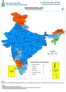 Excessive pre monsoon rains over major states of the country so far till 9th April[/caption] Current synoptic weather features influencing India as on 9 April • The trough in easterlies from Kerala to Vidarbha across interior Karnataka and Marathwada at 0.9 km above mean sea level persists. • The cyclonic circulation over Northeast Bangladesh and neighbourhood at 0.9 km above mean sea level persists. • The cyclonic circulation over Southeast Rajasthan and neighbourhood extending at 1.5 km above mean sea level persists. • The feeble Western Disturbance is seen as a trough in middle tropospheric level westerlies with its axis at 5.8 km above mean sea level roughly along Long. 63⁰E to the north of Lat. 30⁰N persists. All India weather forecast till 15 April, 2023: Anti-cyclonic circulation to results in heat build-up over India The pleasantness in the air is no longer going to stay as anti-cyclonic circulation to emerge over the Indian landmass this week, it is a climate feature - technically, anti-cyclonic circulation is an area of sinking air that results in development of high pressure over a large geography; the area of high pressure experiences a small pressure gradient, the atmospheric pressure and air does not change rapidly and winds become gentle in nature. As the air starts sinking, it warms up, leading to warm and dry weather. On a weather chart features can be seen developing between 500 to 850 hpa vertical height as winds in anticyclonic circulation rotates in clockwise direction. As the feature is likely to form up over Madhya Pradesh this week, dry and hot winds are going to rule across the nation, additionally sunny and clear weather will add more heat to the environment. [caption id=“attachment_12432882” align=“alignnone” width=“556”]
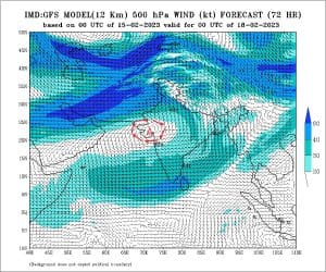 Anti-cyclonic circulation visible in the weather chart over west - central India[/caption] During the period of 12 to 15 April hot weather is expected across Punjab, Haryana, Delhi NCR, Uttar Pradesh with maximum temperatures in the range of 38 to 41°c while as high as 42 to 43°c in Bihar, Jharkhand, Odisha, Chhattisgarh, Telangana, West Bengal and Vidarbha region of Maharashtra. Delhi NCR is likely to touch 40°c by 13 to 15 April. Season’s first heatwave conditions are very likely to develop in parts of Jharkhand, Bihar, Odisha, Chhattisgarh, Vidarbha by 15 April. [caption id=“attachment_12432902” align=“alignnone” width=“555”]
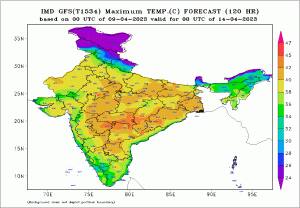 Maximum temperature prediction for India - large parts of the country to cross 40 degrees temperature mark this week[/caption] When is the heatwave declared? The met terminology says, heatwave is declared when the actual maximum temperature of the station reaches at least 40°C or above in plains and at least 30°C in hills. Departure of maximum temperature from normal is 4-5°C or more for the regions where the normal maximum temperature is more than 40.0°C and departure of maximum temperature from normal is 5-6°C for regions where the normal maximum temperature is 40.0°c or less. What are the impacts of a heatwave? • Heat waves could lead to moderate health concern for vulnerable people e.g. infants, and elderly people with chronic diseases. • Increased likelihood of heat illness symptoms in people who are either exposed to sun for a prolonged period or doing heavy work. Actions suggested during heatwave • Avoid heat exposure– keep cool. Avoid dehydration. • Drink sufficient water- even if not thirsty. • Avoid heat exposure, wear lightweight, light-coloured, loose, cotton clothes and cover the head by use of cloth, hat or umbrella etc. • Use ORS, homemade drinks like lassi, torani (rice water), lemon water, buttermilk, etc. to keep yourself hydrated. “Eyes still on the clouds” The widespread spell of unseasonal rains have came to an end but still a lower level wind instability is developing around Gujarat by 13 or 14 April, under such scenario isolated to scattered light to moderate rains and thundershowers to occur in interiors of Maharashtra, Gujarat, south Rajasthan during 13 to 15 April with slight probability of some rains are Delhi NCR, Haryana on 15 April. Generally by mid April rains start to increase over India’s north east, also the thunderstorm season begins in Kerala and interiors of Karnataka but currently the features have not yet developed properly this is likely to cause delay in pre-monsoon rains over these parts of the country at least till 20 April. The author, better known as the Rohtak Weatherman, interprets and explains complex weather patterns. His impact-based forecasts @navdeepdahiya55 are very popular in north India. Read all the
Latest News ,
Trending News ,
Cricket News ,
Bollywood News , India News and
Entertainment News here. Follow us on
Facebook,
Twitter and
Instagram.
Maximum temperature prediction for India - large parts of the country to cross 40 degrees temperature mark this week[/caption] When is the heatwave declared? The met terminology says, heatwave is declared when the actual maximum temperature of the station reaches at least 40°C or above in plains and at least 30°C in hills. Departure of maximum temperature from normal is 4-5°C or more for the regions where the normal maximum temperature is more than 40.0°C and departure of maximum temperature from normal is 5-6°C for regions where the normal maximum temperature is 40.0°c or less. What are the impacts of a heatwave? • Heat waves could lead to moderate health concern for vulnerable people e.g. infants, and elderly people with chronic diseases. • Increased likelihood of heat illness symptoms in people who are either exposed to sun for a prolonged period or doing heavy work. Actions suggested during heatwave • Avoid heat exposure– keep cool. Avoid dehydration. • Drink sufficient water- even if not thirsty. • Avoid heat exposure, wear lightweight, light-coloured, loose, cotton clothes and cover the head by use of cloth, hat or umbrella etc. • Use ORS, homemade drinks like lassi, torani (rice water), lemon water, buttermilk, etc. to keep yourself hydrated. “Eyes still on the clouds” The widespread spell of unseasonal rains have came to an end but still a lower level wind instability is developing around Gujarat by 13 or 14 April, under such scenario isolated to scattered light to moderate rains and thundershowers to occur in interiors of Maharashtra, Gujarat, south Rajasthan during 13 to 15 April with slight probability of some rains are Delhi NCR, Haryana on 15 April. Generally by mid April rains start to increase over India’s north east, also the thunderstorm season begins in Kerala and interiors of Karnataka but currently the features have not yet developed properly this is likely to cause delay in pre-monsoon rains over these parts of the country at least till 20 April. The author, better known as the Rohtak Weatherman, interprets and explains complex weather patterns. His impact-based forecasts @navdeepdahiya55 are very popular in north India. Read all the
Latest News ,
Trending News ,
Cricket News ,
Bollywood News , India News and
Entertainment News here. Follow us on
Facebook,
Twitter and
Instagram.
Hot weather is expected across Punjab, Haryana, Delhi NCR, Uttar Pradesh with maximum temperatures in the range of 38 to 41°c and as high as 42 to 43°c in Bihar, Jharkhand, Odisha, Chhattisgarh, Telangana, West Bengal and Vidarbha region
Advertisement
End of Article

 "Russian drones over Poland: Trump’s tepid reaction a wake-up call for Nato?")
 "As Russia pushes east, Ukraine faces mounting pressure to defend its heartland")
 "Why Mossad was not on board with Israel’s strike on Hamas in Qatar")
 "Turkey: Erdogan's police arrest opposition mayor Hasan Mutlu, dozens officials in corruption probe")


