
 "Weather Report: Rains to hit east India midweek, low pressure area may form in Bay of Bengal soon")
It was the midnight of 15 June when one of the longest surviving cyclones in the Arabian sea made a landfall over the coast of north west Gujarat in India. It was a compact weather system in terms of structure capable of bringing extreme rains over limited areas of impact. Under the influence very heavy to extremely heavy rains were recorded in many parts of western Gujarat along with maximum wind gusts of 100-120 km/h. Rainfall recorded in various stations of Gujarat in the span of 48 hours ending 6:00 AM on 17 June 2023. State department stations: Bhuj: 354 mm Anjar: 351 mm Gandhidham: 346 mm Mundra: 320 mm Bachhau: 271 mm Khambhaliya: 233 mm IMD stations: Okha: 352 mm Kandla Airport: 283 mm Dwarka: 202 mm Rajkot: 151 mm After Gujarat state, most parts of south Rajasthan experienced heavy rains ending 8:30 AM on 17 June. Sedwa (Barmer): 140 mm Mount Abu (Sirohi): 130 mm Raniwara (Jalore): 110 mm Bidasar (Churu): 80 mm Reodar (Sirohi): 70 mm Deldhar (Sirohi): 70 mm Pindwara (Sirohi): 70 mm Sanchore (Jalore): 60 mm Jalore: 50 mm Girwa (Udaipur): 50 mm On 17 June the remnants of cyclone Biparjoy as a depression established itself over south west Rajasthan resulting in record shattering extremely heavy rains and flash floods in various parts of the Jodhpur, Barmer, Jalore, Sirohi districts, rainfall ending 8:30 AM on 18 June. Ker: 350 mm Raniwada: 320 mm Jalore: 320 mm Sheoganj: 315 mm Sanchor: 300 mm Jaswantpura: 290 mm Mount Abu: 280 mm Sumerpur: 270 mm Chohtan: 266 mm Rani: 249 mm [caption id=“attachment_12757292” align=“alignnone” width=“626”] Satellite imagery shows deep convection over southern parts of Rajasthan on 18 June due to prevailing depression the remnant of Cyclone Biparjoy[/caption] One of IMD’s weather station at Jawai Dam in Pali district of Rajasthan recorded 226.0 mm Rainfall in the span of 24 hours ending 8:30 AM on 18 June this became the highest ever single day and highest monthly rainfall for the month of June breaking the previous single day record of 78.3 mm from 25 June 1977. Highest monthly cumulative record was of 137.1 mm from June 1955. Interestingly, the annual rainfall average at Jawai Dam is 505.3 mm only, many such remote stations in south Rajasthan have surpassed their annual average with 2 days of rain accumulation, remember monsoon is yet to arrive! [caption id=“attachment_12757322” align=“alignnone” width=“627”]
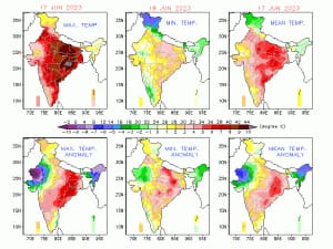 Extreme low temperature anomaly in Rajasthan due to the impact of Cyclone Biparjoy[/caption] It was a deficient pre monsoon season for the states of north east India but since the monsoon had made an onset wet phase has commenced across most states. Cherrapunji continued its run of experiencing very heavy rains as accumulated 1152 mm rainfall in the past 5 days. Exact day level rainfall figures for the station. 14 June: 200mm 15 June: 194mm 16 June: 426mm 17 June: 161mm 18 June: 171mm What is the current status of Monsoon 2023? • The Northern Limit of Monsoon (NLM) continues to pass through lat. 16.5°N/ long. 55°E, lat. 17.0°N/ long. 60°E, lat. 17°N/ long. 65°E, lat. 17°N/ long. 70°E, Ratnagiri, Koppal, Puttaparthi, Shriharikota, lat. 15.0°N/ long. 83.0°E, 18.0°N/87.0°E, 22°N/89.5°E, Malda and Forbesganj, 28°N/86°E. • Conditions are favourable for further advance of Southwest Monsoon over some more parts of south Peninsular India, West Bengal, Jharkhand and Bihar during next 2-3 days. • More than a half of June has passed but the progress of monsoon continue to stay sluggish as cyclone Biparjoy hampered the development of monsoon dynamics in the Arabian sea branch, at the same time progress of bay of Bengal branch is restricted to north east India only as the key factor of development of low pressure area in Bay of Bengal has seen so far. • As an impact the core monsoon zone of east and central India which is highly dependent on the seasonal rains for the agricultural practices such as sowing of kharif is consistently getting delayed. • The delay in monsoon onset is reflecting well on paper as well, till 18 June India as a whole has received 50.6 mm rainfall against the normal of 80.6 mm, departure from normal stands at -37 per cent. Subdivision wise seasonal rainfall till 18 June 2023: • Southern Peninsula: Actual 35.7mm against the average of 92.1mm, -61 per cent departure from normal. • East and North East India: Actual 129.6 mm against the average of 171.9 mm, -25 per cent departure from normal. • North West India: Actual 38.3 mm against the average of 33.9 mm, +13 per cent departure from normal. • Central India: Actual 33.1 mm against the average of 73.5 mm, -55 per cent departure from normal. [caption id=“attachment_12757332” align=“alignnone” width=“587”]
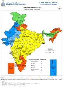 Monsoon seasonal rains over meteorological subdivisions of India till 18 June, 2023[/caption] All India weather forecast till 25 June 2023: The remnant of cyclone Biparjoy as a depression is expected to dissipate in the next two days over north Madhya Pradesh, it will be the right time for the monsoon to regain its lost pace and start progress towards the remaining parts of the country. [caption id=“attachment_12757342” align=“alignnone” width=“592”]
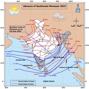 Status of monsoon onset progress 18 June, 2023[/caption] A low pressure area is expected to form in the head Bay of Bengal around 22 June and move inland towards central India. Typical seasonal monsoon axis is also expected to establish over Indo-Gangetic plains. The pull effect from the Bay of Bengal will also pull westerlies along the west coast of India and proper off-shore trough is expected to form up and activate by mid week. Overall development of all these synoptic parameters indicate monsoon rains to turn active over the already onset states and further advancement of monsoon will pick up pace next week. Under the influence of the weather systems monsoon is expected to revive with a bang! Moderate to heavy rains to lash heatwave prone zones of Bihar, Jharkhand, Odisha, West Bengal, Chhattisgarh, Telangana, Andhra Pradesh, eastern Uttar Pradesh and east Madhya Pradesh and over remaining parts of Maharashtra during 23 till 25 June, along with that rains are expected to increase significantly in states of southern peninsula early next week. The core monsoon zones of the country had waited long for the monsoons to set in this year, but it’s not too far from north India. Once the monsoon axis gets established over the plains and bay, low pressure area moves inland, it will trigger the flow of moist easterlies, and with the probability of enhanced precipitation, conditions are expected to become favourable for further advancement of the monsoon in Uttar Pradesh, Uttarakhand, Himachal Pradesh, Jammu, Chandigarh, Delhi NCR, Punjab, and some parts of eastern Rajasthan during the 25 to 29 June. This might turn out to be slightly early monsoon onset for the northern region of the country. Summer 2023 is about to end without any heatwave or severe heatwave event in north India this year, Punjab, Haryana, Delhi NCR were not able to cross 45°c temperature mark for any day but it might turn out to be one of the toughest in terms of heat index just like 2014 as the months of July and August approaches along with long lasting break in monsoon conditions can be expected in El Nino impact years. The author, better known as the Rohtak Weatherman, interprets and explains complex weather patterns. His impact-based forecasts @navdeepdahiya55 are very popular in north India. Read all the
Latest News ,
Trending News ,
Cricket News ,
Bollywood News , India News and
Entertainment News here. Follow us on
Facebook,
Twitter and
Instagram.
Status of monsoon onset progress 18 June, 2023[/caption] A low pressure area is expected to form in the head Bay of Bengal around 22 June and move inland towards central India. Typical seasonal monsoon axis is also expected to establish over Indo-Gangetic plains. The pull effect from the Bay of Bengal will also pull westerlies along the west coast of India and proper off-shore trough is expected to form up and activate by mid week. Overall development of all these synoptic parameters indicate monsoon rains to turn active over the already onset states and further advancement of monsoon will pick up pace next week. Under the influence of the weather systems monsoon is expected to revive with a bang! Moderate to heavy rains to lash heatwave prone zones of Bihar, Jharkhand, Odisha, West Bengal, Chhattisgarh, Telangana, Andhra Pradesh, eastern Uttar Pradesh and east Madhya Pradesh and over remaining parts of Maharashtra during 23 till 25 June, along with that rains are expected to increase significantly in states of southern peninsula early next week. The core monsoon zones of the country had waited long for the monsoons to set in this year, but it’s not too far from north India. Once the monsoon axis gets established over the plains and bay, low pressure area moves inland, it will trigger the flow of moist easterlies, and with the probability of enhanced precipitation, conditions are expected to become favourable for further advancement of the monsoon in Uttar Pradesh, Uttarakhand, Himachal Pradesh, Jammu, Chandigarh, Delhi NCR, Punjab, and some parts of eastern Rajasthan during the 25 to 29 June. This might turn out to be slightly early monsoon onset for the northern region of the country. Summer 2023 is about to end without any heatwave or severe heatwave event in north India this year, Punjab, Haryana, Delhi NCR were not able to cross 45°c temperature mark for any day but it might turn out to be one of the toughest in terms of heat index just like 2014 as the months of July and August approaches along with long lasting break in monsoon conditions can be expected in El Nino impact years. The author, better known as the Rohtak Weatherman, interprets and explains complex weather patterns. His impact-based forecasts @navdeepdahiya55 are very popular in north India. Read all the
Latest News ,
Trending News ,
Cricket News ,
Bollywood News , India News and
Entertainment News here. Follow us on
Facebook,
Twitter and
Instagram.
Conditions are expected to become favourable for further advancement of the monsoon in Uttar Pradesh, Uttarakhand, Himachal Pradesh, Jammu, Chandigarh, Delhi NCR, Punjab, and some parts of eastern Rajasthan during the 25 to 29 June
Advertisement
End of Article

 "Russian drones over Poland: Trump’s tepid reaction a wake-up call for Nato?")
 "As Russia pushes east, Ukraine faces mounting pressure to defend its heartland")
 "Why Mossad was not on board with Israel’s strike on Hamas in Qatar")
 "Turkey: Erdogan's police arrest opposition mayor Hasan Mutlu, dozens officials in corruption probe")


