 "Weather Report: North India to have respite from incessant rains midweek")
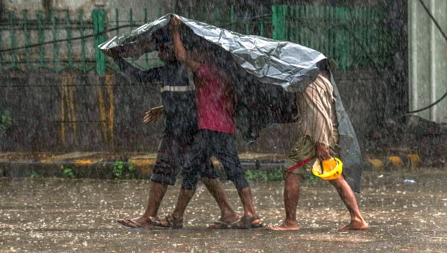
This week it felt like monsoon is here in the country, the low pressure area from the Bay of Bengal travelled across central India, activated offshore trough on the west coast later the monsoon axis merger with the western disturbance trough is resulting in catastrophic weather events in the plains of north India along with western Himalayas as record shattering rains occurred over the weekend. Chandigarh the combined capital of Punjab and Haryana also known as city beautiful breaks the all time record by experiencing 302 mm rainfall ending 8:30 AM in the span of 24 hours on 9 July 2023, following the data trends Tricity has never experienced a spell of rain above 300 mm mark in the lifetime or say since the record keeping begin by IMD, also turns out to be a extreme spell of rain when the monthly average of 275 mm is surpassed in a mere period of 24 hours. Reports of flooding, uprooted trees and damage to infrastructure are reported from the city and nearby areas as Ropar recorded 236 mm, Balachar 268 mm, Ambala 224 mm all these stations recorded the all time highest single day rainfall of the history. The national capital Delhi experienced very heavy rains starting Saturday morning. The accumulation in the period of 24 hours recorded as 153 mm at the Safdarjung observatory till 8:30 AM on 9 July, it is the third highest single day rainfall recorded in the month of July since the record keeping began. Previous records as follows:
- 21st July 1958: 266.2 mm
- 26th July 1982: 169.9 mm
- 9th July 2023: 153 mm
- 10th July 2003: 133.4 mm
- 28th July 2009: 126 mm
Further, Safdarjung observatory hit another century by recording 105.8 mm rainfall till 5:30 PM on 9 July, accumulated 259 mm rains in the span of 36 hours, Delhi experienced 33 per cent of annual rainfall quota in just 36 hours. Vigorous monsoon sets the stage for the country to get into the normal seasonal rainfall category as multiple states experienced heavy rains in the past week. In the period of 1 June till 9 July, India as a whole has received 243.2 mm rainfall against the normal of 239.1mm, departure from normal stands at +2 per cent compared to week on week of -13 per cent. Subdivision wise seasonal rainfall till 9 July 2023:
- Southern Peninsula: Actual 166.7 mm against the average of 215.4 mm, -23 per cent departure from normal.
- East and North East India: Actual 375.3 mm against the average of 454.0 mm, -17 per cent departure from normal.
- North West India: Actual 199.7 mm against the average of 125.5 mm, +59 per cent departure from normal.
- Central India: Actual 264.9 mm against the average of 255.1 mm, +4 per cent departure from normal.
[caption id=“attachment_12847492” align=“alignnone” width=“472”]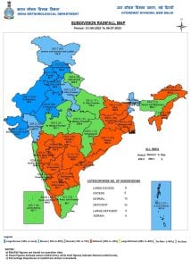 Subdivision wise seasonal rainfall in the period of 1 June till 9 July 2023[/caption] Subdivisions north west India under large excess seasonal rainfall category as extreme rains occurred in the region earlier under the influence of cyclone Biparjoy and now another major spell occurred over the weekend as western disturbance and Monsoon axis interacted. - Uttarakhand 308.4 mm against the normal of 282.8 mm, +9 per cent departure from normal. - Himachal Pradesh 272.3 mm against the normal of 160.6 mm, +70 per cent departure from normal. - East Rajasthan 243.8 mm against the normal of 122.7 mm, +99 per cent departure from normal. - West Rajasthan 206.4 mm against the normal of 60.9 mm, +239 per cent departure from normal. - West Uttar Pradesh 205.5 mm against the normal of 135.0 mm, +52 per cent departure from normal. - Punjab 183.3 mm against the normal of 91.7 mm, +100 per cent departure from normal. - East Uttar Pradesh 159.3 mm against the normal of 179.2 mm, -11 per cent departure from normal. - Haryana, Chandigarh and Delhi 143.8 mm against the normal of 89.2 mm, +61 per cent departure from normal. [caption id=“attachment_12847532” align=“alignnone” width=“422”]
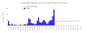 Daily mean seasonal rainfall over northwest India so far in this monsoon season[/caption] Current synoptic weather features influencing weather in India as on 9 July 2023
The monsoon trough at mean sea level now passes through Jaisalmer, Ajmer, Shivpuri, Sidhi, Daltonganj, Shanti Niketan and thence eastwards to Manipur and extends up to 1.5 km above mean sea level.
The cyclonic circulation over West Rajasthan now lies over central Rajasthan & neighbourhood and extends upto 3.1 km above mean sea level.
The Western Disturbance as a trough between 3.1 & 9.5 km above mean sea level with its axis at 5.8 km above mean sea level now runs roughly from Lat. 35°N./ Long. 68°E to Lat. 23°N./ Long. 65°E.
The off-shore trough at mean sea level from south Gujarat coast to north Kerala coast persists.
[caption id=“attachment_12847542” align=“alignnone” width=“387”]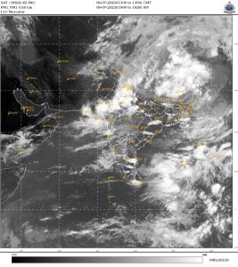 Satellite imagery from Sunday evening shows strong convective clouds over Delhi NCR, Haryana, West UP and Rajasthan resulting in heavy rains[/caption] All India weather forecast till 16 July 2023 The rampage of western disturbance and monsoon axis interaction will persist in Himachal Pradesh, Uttarakhand, Punjab, Haryana, Delhi NCR, Rajasthan on Monday as heavy rains would continue, possibility of urban flooding in the plains, flash floods, landslides, mud slides will exist over the western Himalayas on Monday till early Tuesday, post that relatively dry weather would take cover the region for next two to three days also bring respite from incessant rains, the weather gods to provide relief to flood prone areas also a chance for the administrations to start restoration operations on a full scale, the damage is done Himachal Pradesh will take some time to recover from the weather fury. As the interaction fades away rains will decline and would mainly restrict till Uttar Pradesh as the flow of easterlies will be there across the week, as another low pressure area is expected to form in Bay of Bengal around next weekend the easterlies will once again start penetrating deep into the plains and next spell of scattered rains will pick up around the next weekend over north west India. As north is expected see decline in rainfall this week, east, central and north eastern states of Bihar, Jharkhand, West Bengal, Chhattisgarh, Odisha, Madhya Pradesh, Meghalaya, Mizoram, Manipur, Nagaland, Arunachal Pradesh, Sikkim to witness a wet week ahead as sufficient moisture inflow from Bay of Bengal to trigger good rains over these states. The off-shore trough will be active on and off across this week hence mainly moderate showers to be recorded in Kerala, Goa, Coastal Karnataka and Maharashtra across this week. Whereas it is likely to be another week with low rainfall performance in most parts of interiors of Maharashtra, Telangana, Andhra Pradesh and Tamil Nadu, as low pressure areas from Bay of Bengal are not at all travelling across these regions, some parts of middle Maharashtra and Marathwada had started showing signs of drought. The author, better known as the Rohtak Weatherman, interprets and explains complex weather patterns. His impact-based forecasts @navdeepdahiya55 are very popular in north India. Read all the
Latest News
,
Trending News
,
Cricket News
,
Bollywood News
, India News
and
Entertainment News
here. Follow us on
Facebook
,
Twitter
and
Instagram
.
Satellite imagery from Sunday evening shows strong convective clouds over Delhi NCR, Haryana, West UP and Rajasthan resulting in heavy rains[/caption] All India weather forecast till 16 July 2023 The rampage of western disturbance and monsoon axis interaction will persist in Himachal Pradesh, Uttarakhand, Punjab, Haryana, Delhi NCR, Rajasthan on Monday as heavy rains would continue, possibility of urban flooding in the plains, flash floods, landslides, mud slides will exist over the western Himalayas on Monday till early Tuesday, post that relatively dry weather would take cover the region for next two to three days also bring respite from incessant rains, the weather gods to provide relief to flood prone areas also a chance for the administrations to start restoration operations on a full scale, the damage is done Himachal Pradesh will take some time to recover from the weather fury. As the interaction fades away rains will decline and would mainly restrict till Uttar Pradesh as the flow of easterlies will be there across the week, as another low pressure area is expected to form in Bay of Bengal around next weekend the easterlies will once again start penetrating deep into the plains and next spell of scattered rains will pick up around the next weekend over north west India. As north is expected see decline in rainfall this week, east, central and north eastern states of Bihar, Jharkhand, West Bengal, Chhattisgarh, Odisha, Madhya Pradesh, Meghalaya, Mizoram, Manipur, Nagaland, Arunachal Pradesh, Sikkim to witness a wet week ahead as sufficient moisture inflow from Bay of Bengal to trigger good rains over these states. The off-shore trough will be active on and off across this week hence mainly moderate showers to be recorded in Kerala, Goa, Coastal Karnataka and Maharashtra across this week. Whereas it is likely to be another week with low rainfall performance in most parts of interiors of Maharashtra, Telangana, Andhra Pradesh and Tamil Nadu, as low pressure areas from Bay of Bengal are not at all travelling across these regions, some parts of middle Maharashtra and Marathwada had started showing signs of drought. The author, better known as the Rohtak Weatherman, interprets and explains complex weather patterns. His impact-based forecasts @navdeepdahiya55 are very popular in north India. Read all the
Latest News
,
Trending News
,
Cricket News
,
Bollywood News
, India News
and
Entertainment News
here. Follow us on
Facebook
,
Twitter
and
Instagram
.