
 "Weather report: North India will continue to shiver, South experiences short, mild winters")
The plains of north India have been experiencing an unbeatable cold since the beginning of 2024. The cold days have become a permanent feature across Punjab, Haryana, Delhi NCR, Uttar Pradesh, and now even expanding to Bihar, Jharkhand, and Madhya Pradesh in the past week. The maximum temperature anomaly is below normal by -5 to -10°C on a monthly level; this is a huge delta when observed over a period of 20 days consistently. The sun is getting no chance to show up properly as a layer of fog is acting as a barrier. There are a lot of stations where sunshine hours so far in the month of January are at an all-time low. Take a look at the maximum temperature recorded in the plains of north India on January 19, and it has been on a similar line across the week or so far in the month:
Jhansi in Uttar Pradesh recorded a maximum temperature of 10.0°C (-12.3°C below normal)
Moga: 8.3°C
Barnala: 8.7°C
Fatehabad: 9.3°C
Jind: 9.5°C
Mahendragarh: 10.0°C
Mandkola: 10.1°C
Bareilly: 10.2°C
Faridabad: 10.6°C
Najibabad: 10.8°C
Alwar: 11.0°C
Meerut: 11.0°C
It is not just the days, but the nights are equally colder, as some of the stations are reporting minimum temperatures nearing the freezing point. Let’s take a look at the minimum temperature at various stations in the plains of north India on January 21: Fatehpur: 0.5°C Rewari: 1.4°C Gurgaon: 1.7°C Mahendragarh: 2.2°C Hisar: 2.8°C Hathras: 3.0°C Faridabad: 3.5°C Lodi Road: 4.0°C Meerut: 4.3°C Rohtak: 4.6°C New Delhi: 4.8°C Chandigarh: 5.2°C Kanpur: 6.8°C [caption id=“attachment_13643812” align=“alignnone” width=“557”] Temperature anomaly in the month of January 2024 so far shows exceptionally below normal maximum temperatures in plains of north India[/caption] Dense to very dense fog has again engulfed many parts of Sunday morning disrupting air traffic, road and railways, take a look at the visibility reported from various stations at 8:30 am on 21st January (≤200 metres): • Haryana: Chandigarh and Hisar - 25 m, Chandigarh - 50 m, Ambala - 200 m. • West Rajasthan: Jaisalmer - 25 m, Bikaner and Churu - 50 m each. • West Uttar Pradesh: Bareilly - 25 m, Meerut and Jhansi - 50 m each. • West Madhya Pradesh: Bhopal - 25 m, Gwalior, Guna and Rajgarh - 50 m each. • East Madhya Pradesh: Satna - 25 m, Rewa - 50 m, Damoh and Mandla - 200 m. • Jammu: 50 m. • Uttarakhand: Pantnagar - 50 m, Dehradun - 200 m. • Punjab: Patiala - 50m, Amritsar and Ludhiana - 200m. • Delhi: Palam, Safdarjung, Ridge and Ayanagar - 50 m. • Sub-Himalayan West Bengal: Jalpaiguri and Cooch Behar - 50 m, Baghdogra - 200m. • Assam: Dhubri - 50m. • Tripura: Agartala and Kailashahar - 50 m each. • Central Uttar Pradesh: Lucknow - 200m. The cold weather is certainly travelling to the centre and west now as coldwave conditions are observed over a few stations in Madhya Pradesh on January 21, as the minimum temperature dips below normal. Datia: 3.2°C Gwalior: 4.1°C Rajgarh: 4.4°C Sagar: 4.7°C Guna: 4.8°C Khajuraho: 6.0°C Nowgong: 6.0°C Satna: 6.2°C Bhopal: 7.4°C On Sunday morning, Mumbai saw its coldest day of the season as the minimum temperature fell to 16.1°C. However, the wait for sub-15°C continues. Minimum temperature in various stations of Kokan region: Talasari: 11.5°C Badlapur: 13.2°C Savarde: 13.5°C Karjat: 13.7°C Virar: 14.0°C Dapoli: 14.7°C Kalyan: 15.1°C Panvel: 15.5°C Thane: 15.7°C Navi Mumbai: 16.1°C The actual rainfall in Pan India so far in the period from January 1 to January 20 stands at 5.0 mm against the normal of 10.2 mm; the departure from normal currently stands at -51 per cent. It has increased by 20 per cent week over week as mostly dry weather conditions have prevailed in the country except for little rain in the eastern parts. Subdivision-wise winter seasonal rainfall till January 20, 2024: • Southern peninsula: Actual 16.7 mm against the average of 6.3 mm, +164 per cent departure from normal. • East and northeast India: Actual 3.1mm against the average of 9.8 mm, -68 per cent departure from normal. • Northwest India: Actual 0.7 mm against the average of 18.9 mm, -96 per cent departure from normal. • Central India: Actual 2.9 mm against the average of 4.6 mm, -37 per cent departure from normal. [caption id=“attachment_13643832” align=“alignnone” width=“526”]
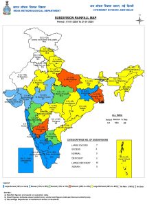 Subdivision-wise seasonal rainfall in India from January 1 to 21, 2024[/caption] Current synoptic weather features influencing weather in India as on January 21, 2024:
- Jet stream winds of the order of 130–140 knots at 12.6 km above mean sea level continue to prevail over the plains of north India.
- The trough in easterlies from south interior Karnataka to east Vidarbha across north interior Karnataka and Marathwada at 0.9 km above mean sea level persists.
- The cyclonic circulation over north Madhya Pradesh, extending up to 1.5 km above mean sea level, persists.
- The feeble western disturbance as a trough in middle tropospheric westerlies, with its axis at 5.8 km above mean sea level, now runs roughly along Long. 80°E to the north of Lat. 32°N.
- The cyclonic circulation over north Haryana and the neighbourhood between 1.5 and 3.1 km above mean sea level has been less marked.
All India weather forecast till January 28, 2024: Severe coldwave conditions are predicted for Punjab, Haryana, Rajasthan, Delhi NCR, Uttar Pradesh, Madhya Pradesh, Bihar, and Jharkhand this week, as the minimum temperature is expected to dip by 1-2°C from current levels. Also, dense fog will remain unabated for another week despite wind speed increasing from the north-west. Cold day conditions will continue to prevail at least till the Republic Day, as the maximum temperature is projected to stay in the range of 10 to 17°C across various stations in the plains of north India till January 26. The first few days of the upcoming week will remain dry and warm for the western Himalayas, but after a long wait, a feeble western disturbance will influence hilly states on January 26 and 27. Conditions are becoming conducive for light to moderate snowfall over Kashmir and Ladakh, while only light rains are expected to occur in Himachal Pradesh and Uttarakhand on both days. While this won’t be a complete relief for the parched hill stations, something is better than nothing. Hopefully, medium-range weather models are indicating moderate intensity of western disturbances for the Himalayas at the end of January and in the month of February. The prolonged spell of dry winters is going to end very soon. Southern parts of India will continue to experience dry weather conditions and the short phase of winters will come to an end by the end of this week as both minimum and maximum temperature is projected to rise by 2-3°C from current levels in Kerala and Tamil Nadu. Due to the interaction of north-west winds with the easterlies of the Bay of Bengal, one can expect scattered light to moderate rains in south Chhattisgarh, Odisha, and West Bengal from January 22 to 25. A fresh spell of light snowfall is also predicted to occur in Sikkim and Arunachal Pradesh at the same time. However, the remaining states in north-east India will experience the most dry weather conditions until January 28. The writer, better known as the Rohtak Weatherman, interprets and explains complex weather patterns. His impact-based forecasts @navdeepdahiya55 are very popular in north India. Views expressed in the above piece are personal and solely those of the author. They do not necessarily reflect Firstpost_’s views._ Read all the Latest News , Trending News , Cricket News , Bollywood News , India News and Entertainment News here. Follow us on Facebook, Twitter and Instagram.

 "Russian drones over Poland: Trump’s tepid reaction a wake-up call for Nato?")
 "As Russia pushes east, Ukraine faces mounting pressure to defend its heartland")
 "Why Mossad was not on board with Israel’s strike on Hamas in Qatar")
 "Turkey: Erdogan's police arrest opposition mayor Hasan Mutlu, dozens officials in corruption probe")


