
 "Weather report | North India to turn dry after light showers; warmer days ahead for South")
The long wait for wet weather in northern India came to an end. Back-to-back two active western disturbances approached in the past week, causing the first spell of widespread, varied intensity snowfall across the western Himalayas. This comes after rainfall observed in January 2024 pan-India was 7.2 mm; it was the ninth lowest since 1901, while northwest India, with only 3.1 mm of rainfall, recorded the second driest January since 1901. The southern peninsula experienced the third wettest January since 2001, with 18.2 mm of rainfall for the month. All thanks for the western disturbance that broke the jinx as soon as February started. A western disturbance is an extratropical storm or a cold front system that originates from the Mediterranean, Caspian, and Black Sea. It moves from west to east with moisture carried on the mid- to upper atmosphere and also embedded in the mid-latitude subtropical westerly jet stream. In India, the impact is observed annually, but with more dedication during the winter months, when they are the only source of snowfall over the Himalayas and rains in the plains of north India. It has great importance in agriculture, particularly for Rabi crops. Snowfall during January 31–February 3 at some stations in Himachal Pradesh, Kashmir, and Uttarakhand: Kothi (Kullu): 100.0 cm Khadrala (Shimla): 65.0 cm Shillaro (Shimla): 62.6 cm Gulmarg: 62.2 cm Bharmour: 46.6 cm Manali: 45.7 cm Kokernag: 42.2 cm Keylong: 36.5 cm Pahalgam: 33.6 cm Dhanolti: 15.0 cm Mussoorie: 10.0 cm Shimla: 5.0 cm The cloud cover and snowfall also resulted in severe coldwave conditions at the hill stations, as both day and night temperatures registered a significant dip. Sonamarg: -4.6°C Gulmarg: -2.6°C Narkanda: -0.7°C Manali: 1.1°c Banihal: 2.0°C Harshil: 0.8°C Reckong Peo: 1.8°C Dhanolti: 2.5°C Shimla: 3.3°C Shama: 4.1°C With fresh snow and clear skies at night, Sonamarg’s minimum temperature dipped to -15.1°C on February 2. Shimla city saw -0.6°C. This is the first subzero after two years. Gulmarg: -12.0°C Pahalgam: -11.9°C Qazigund; -9.4°C Kukernag: -9.4°C Kalpa: -7.0°C Narkanda: -6.1°C On February 2, 2024, Banihal, Bhaderwah, Qazigund, and Batote recorded the lowest temperature in the month of February, at least in the last 16 years. [caption id=“attachment_13690112” align=“alignnone” width=“300”] Western Himalayas had a warm January this year. February began with below-normal temperatures.[/caption] The northern plains experienced good rains on January 31 and February 1. Delhi Safdarjung observatory recorded 26.5 mm of rainfall ending at 8:30 am on February 1, surpassing the monthly rainfall normal of 21.3 mm on the first day of February itself. This comes after a very dry January when the capital saw 0 mm of rainfall against the normal of 19.1 mm, a 100 per cent departure from normal. Good rainfall figures from Punjab, Haryana, and Delhi NCR on February 1: Punjab Tibri: 35 mm Nakodar: 34 mm Phangota: 27 mm Malikpur: 23.8 mm Taran Taran: 23.4 mm Ranjit Sagar Dam: 20.5 mm Haryana Pehowa: 26 mm Kharkoda: 24 mm Hathin: 23 mm Gohana: 21 mm Rohtak: 20 mm New Delhi Safdarjung: 26.5 mm Lodhi Road: 24.6 mm Ridge: 23.3 mm [caption id=“attachment_13690122” align=“alignnone” width=“300”]
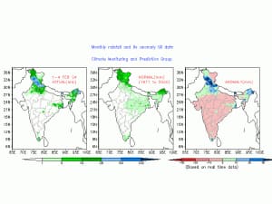 North-west India experienced above-normal rainfall in the first week of February 2024[/caption] The pan-India actual rainfall so far in the period of 1st till 3rd February stands at 11.5 mm against the normal of 18.5 mm; the departure from normal currently stands at -38 per cent, reduced by 19 per cent week over week. Subdivision-wise winter seasonal rainfall till February 3, 2024: • Southern peninsula: Actual 18.5 mm against the average of 8.3 mm, +123 per cent departure from normal. • East and Northeast India: Actual 12.2 mm against the average of 19.7 mm, -38 per cent departure from normal. • Northwest India: Actual 13.4 mm against the average of 36.1 mm, -63 per cent departure from normal. • Central India: Actual 5.4 mm against the average of 7.9 mm, -32 per cent departure from normal. [caption id=“attachment_13690132” align=“alignnone” width=“214”]
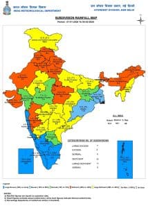 Subdivision-wise seasonal rainfall in India as of February 4, 2024[/caption] Current synoptic weather features influencing weather in India as of February 4, 2024: Jet stream winds of the order of 130–1400 knots at 12.6 km above mean sea level are prevailing over North India. The western disturbance, as a trough in middle tropospheric westerlies with its axis at 5.8 km above mean sea level, now runs roughly along Long. 69°E to the north, Lat. 32°N. The induced cyclonic circulation over southwest Rajasthan and adjoining Pakistan now lies over northwest Rajasthan and adjoining Pakistan at 0.9 km above mean sea level. A cyclonic circulation lies over east Bangladesh and the neighbourhood and extends up to 1.5 km above mean sea level. All India weather forecast till February 11, 2024: The new week starting on February 5 will bring light to moderate rains in Uttar Pradesh, Bihar, Jharkhand, and some parts of West Bengal on Monday and Tuesday, and conditions will again turn dry later in the week. States in north India recently saw a spell of wet weather that will gradually become dry starting Monday and for the rest of the week as western disturbances are about to take a brief pause. Clear and dry western conditions are to be observed in Jammu, Kashmir, Ladakh, Himachal Pradesh, Uttarakhand, Chandigarh, Punjab, Haryana, Delhi NCR, Rajasthan, Gujarat, and Madhya Pradesh till February 11. Weather conditions are ideal for a drop in temperatures across north and central India as cold north-west winds are expected to blow from snow-clad Himalayas, especially from February 7 to February 11, when minimum temperatures can be recorded under 5°C at many stations in the plains and coldwave conditions will be experienced for the last time in the current winter season. Moisture availability is on the higher side in the plains, which might result in the formation of dense fog at a few places during the late night and morning hours; however, it won’t be capable of holding during the entire day now as the atmosphere has better ventilation with the higher wind speeds. South India to brace up for warmer days The second week of February is about to begin, and we saw a marginal increase in temperatures from peninsular India in the last 2 weeks. Since the weather is mostly going to stay dry for another week and the wind pattern will mostly be from inland, days will start to become warmer in Kerala, Tamil Nadu, Karnataka, Telangana, Andhra Pradesh, Goa, and Maharashtra. Some stations would start recording maximum temperatures in the range of 35–38 °C. Overall, on a pan-India level, below-normal rains are predicted in the upcoming week. North India would experience below-normal minimum and maximum temperatures by 3-5°C, while south and parts of east India would see above-normal temperatures by 2-3°C, indicating that the winter season is in the last lap and we might start seeing spring after mid-February as temperatures now might start soaring in the absence of western disturbance going forward. The writer, better known as the Rohtak Weatherman, interprets and explains complex weather patterns. His impact-based forecasts @navdeepdahiya55 are very popular in north India. Views expressed in the above piece are personal and solely those of the author. They do not necessarily reflect Firstpost_’s views._ Read all the
Latest News ,
Trending News ,
Cricket News ,
Bollywood News , India News and
Entertainment News here. Follow us on
Facebook,
Twitter and
Instagram.
Subdivision-wise seasonal rainfall in India as of February 4, 2024[/caption] Current synoptic weather features influencing weather in India as of February 4, 2024: Jet stream winds of the order of 130–1400 knots at 12.6 km above mean sea level are prevailing over North India. The western disturbance, as a trough in middle tropospheric westerlies with its axis at 5.8 km above mean sea level, now runs roughly along Long. 69°E to the north, Lat. 32°N. The induced cyclonic circulation over southwest Rajasthan and adjoining Pakistan now lies over northwest Rajasthan and adjoining Pakistan at 0.9 km above mean sea level. A cyclonic circulation lies over east Bangladesh and the neighbourhood and extends up to 1.5 km above mean sea level. All India weather forecast till February 11, 2024: The new week starting on February 5 will bring light to moderate rains in Uttar Pradesh, Bihar, Jharkhand, and some parts of West Bengal on Monday and Tuesday, and conditions will again turn dry later in the week. States in north India recently saw a spell of wet weather that will gradually become dry starting Monday and for the rest of the week as western disturbances are about to take a brief pause. Clear and dry western conditions are to be observed in Jammu, Kashmir, Ladakh, Himachal Pradesh, Uttarakhand, Chandigarh, Punjab, Haryana, Delhi NCR, Rajasthan, Gujarat, and Madhya Pradesh till February 11. Weather conditions are ideal for a drop in temperatures across north and central India as cold north-west winds are expected to blow from snow-clad Himalayas, especially from February 7 to February 11, when minimum temperatures can be recorded under 5°C at many stations in the plains and coldwave conditions will be experienced for the last time in the current winter season. Moisture availability is on the higher side in the plains, which might result in the formation of dense fog at a few places during the late night and morning hours; however, it won’t be capable of holding during the entire day now as the atmosphere has better ventilation with the higher wind speeds. South India to brace up for warmer days The second week of February is about to begin, and we saw a marginal increase in temperatures from peninsular India in the last 2 weeks. Since the weather is mostly going to stay dry for another week and the wind pattern will mostly be from inland, days will start to become warmer in Kerala, Tamil Nadu, Karnataka, Telangana, Andhra Pradesh, Goa, and Maharashtra. Some stations would start recording maximum temperatures in the range of 35–38 °C. Overall, on a pan-India level, below-normal rains are predicted in the upcoming week. North India would experience below-normal minimum and maximum temperatures by 3-5°C, while south and parts of east India would see above-normal temperatures by 2-3°C, indicating that the winter season is in the last lap and we might start seeing spring after mid-February as temperatures now might start soaring in the absence of western disturbance going forward. The writer, better known as the Rohtak Weatherman, interprets and explains complex weather patterns. His impact-based forecasts @navdeepdahiya55 are very popular in north India. Views expressed in the above piece are personal and solely those of the author. They do not necessarily reflect Firstpost_’s views._ Read all the
Latest News ,
Trending News ,
Cricket News ,
Bollywood News , India News and
Entertainment News here. Follow us on
Facebook,
Twitter and
Instagram.
On a pan-India level, below-normal rains are predicted in the upcoming week. North India would experience below-normal minimum and maximum temperatures by 3-5°C, while south and parts of east India would see above-normal temperatures by 2-3°C
Advertisement
End of Article

 "Russian drones over Poland: Trump’s tepid reaction a wake-up call for Nato?")
 "As Russia pushes east, Ukraine faces mounting pressure to defend its heartland")
 "Why Mossad was not on board with Israel’s strike on Hamas in Qatar")
 "Turkey: Erdogan's police arrest opposition mayor Hasan Mutlu, dozens officials in corruption probe")


