
 "Weather report: North India may get Diwali break in air pollution, northeast monsoon hits South")
The northeast monsoon got fine-tuned in the past week, resulting in daily rains in Chennai and various parts of Tamil Nadu. The rain deficient from October is getting recovered quickly as easterlies are in full swing over the state. The top five stations in Chennai are: Alandur: 123 mm Puzhal: 122.7 mm Chennai Airport: 89 mm Adyar: 73 mm Kolathur: 71 mm Perungudi: 70.5 mm Chennai city: 42 mm Kerala was on a setback this year after a failed southwest monsoon, but the law of averages from nature is balancing it with fruitful rains in the northeast monsoon since October. Moderate to heavy rains have continued at various stations in Kerala in the past week and seem unstoppable for another couple of days. Rainfall ending 8:30 am on Saturday at various stations in Kerala: Mancompu: 116 mm Alappuzha: 57.6 mm Haripad: 22 mm Hosdurg: 20 mm Kudulu: 25.4 mm Thalassery: 19.2 mm Irikkur: 25 mm Kannur: 12.4 mm Kozhikode: 49 mm Quilandy: 15 mm Ambalavayal: 11.9 mm Ponnani: 19 mm Nilambur: 17 mm Manjeri: 34 mm Angadippuram: 87 mm Perinthalmanna: 30 mm Chittur: 50 mm Kollengode: 31.8 mm Alathur: 12.5 mm Ottappalam: 16 mm Parambikulam: 20 mm Palakkad: 42.3 mm Further very heavy rains were recorded ending 8:30 am on Sunday in various parts of Kerala: Kochi: 190 mm Neeleswaram: 170 mm Peringalkuthu: 120 mm Aluva: 110 mm [caption id=“attachment_13352712” align=“alignnone” width=“552”] Cumulative rains saw increasing trend in the last two days of the week with increased rains in south India[/caption] South interiors of Karnataka experienced first spell of active northeast monsoon on Saturday when Bangalore HAL Airport reported 35 mm rainfall in the evening, a very crucial ICC world cup match between New Zealand and Pakistan was called off due to incessant rains, Pakistan was declared won via DLS method, this was the first world cup match of 2023 where weather played spoilsport. The pan-India actual rainfall so far in the period of 1 October till 4 November stands at 54.0 mm against the normal of 81.2 mm, the departure from normal currently stands at -34 per cent. Subdivision wise seasonal rains till 4 November 2023 • Southern Peninsula: Actual 74.9 mm against the average of 171.5 mm, -56 per cent departure from normal. • East and North East India: Actual 135.5 mm against the average of 127.2 mm, +7 per cent departure from normal. • North West India: Actual 31.3 mm against the average of 23.3 mm, +34 per cent departure from normal. • Central India: Actual 23.8 mm against the average of 59.5 mm, -60 per cent departure from normal. [caption id=“attachment_13352722” align=“alignnone” width=“463”]
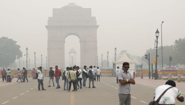
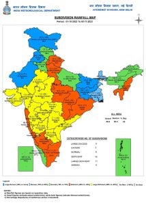 Subdivision wise seasonal rainfall in India till 5 November2023[/caption] Delhi NCR and northern plains of India are back in limelight with terms like “Gas Chamber” as air quality deteriorated amid low wind speed and temperature drops. Meteorological conditions have always played a crucial role in driving pollutants. Under low wind speed and temperature inversion conditions pollutants from every source get trapped in the atmosphere and get no chance of dispersion; this leads to formation of extreme layers of smog for longer duration. Pollution levels in Delhi have remained in the ‘severe plus’ category for the past few days recording AQI in the ‘400’ range at several locations in and around Delhi. On Sunday morning the overall average AQI of 410 was recorded. According to the data from the Central Pollution Control Board, Delhi’s air quality index increased by over 200 points since 27 October. The worst air quality was recorded on 3 November, since the previous high of 471, which was recorded on 12 November 2021. [caption id=“attachment_13352732” align=“alignnone” width=“553”]
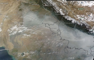 Severe smog layer across the northern plains of India from satellite imagery[/caption] Smog is wrapped across the plains but Himalayas are experiencing clear skies resulting in chill in night, minimum temperature recorded in Jammu, Kashmir, Ladakh on 4 November: Hanle IAO: -10.4°C Nyoma: -9.6°C Padum: -6.7°C Drass: -6.3°C Leh: -5.0°C Kargil: -2.6°C Shopian: -1.4°C Pahalgam: -0.4°C Gulmarg: 0.8°C Srinagar: 3.4°C Bhaderwah: 4.2°C Rajouri: 11.7°C Reasi: 12.6°C Katra: 13.5°C Jammu: 13.8°C Kathua: 15.0°C Current synoptic weather features influencing weather in India as on 5 November 2023 • The cyclonic circulation over south Tamil Nadu and neighborhood now lies over north Tamil Nadu and extends up to 5.8 km above mean sea level tilting southwestwards with height. It is likely to move west-north westwards towards southeast and adjoining east central Arabian sea during next two days. Under its influence, a low pressure area is likely to form over east central Arabian sea around 8 November 2023. • A fresh western disturbance is likely to affect western Himalayan region from the night of 7 November 2023. • The Trough of low in easterlies from north interior Karnataka to the above cyclonic circulation over south Tamil Nadu and neighborhood extending up to 1.5 km above mean sea level has become less marked. All India weather forecast till 12 November 2023 Four states in southern peninsula will continue to drench in good northeast monsoon rains, a low pressure area to develop in east central Arabian sea on 8 November will pull and strengthen easterlies across the Tamil Nadu coast under the influence moderate to heavy rains are expected across Tamil Nadu, Kerala,southern parts of Karnataka during 6–10 November. Light to moderate showers will occur in various parts of Andhra Pradesh, Telangana, Goa on Monday and Tuesday and dry weather will return in the region mid week onwards. Active spell of rains will help southern states to quickly recover from the current rainfall deficit of -56 per cent to at least -30 per cent by the end of the week. Weather in central and eastern parts of the country will continue to stay dry along with warm and sunny during the day time, cool in the night as minimum temperature likely in the range of 15 to 20°C across various cities. North India anticipates western disturbance this week A fresh western disturbance is on its way to affect the western Himalayas from 7 to 10 November, with fresh moderate snowfall over Kashmir, Ladakh and Himachal Pradesh. It will also bring light to moderate rains and thunderstorms in Jammu, the lower hill ranges of Himachal Pradesh, and Uttarakhand on 8 and 9 November. Although the weather system will have nominal impact in terms of rain in Delhi NCR, Haryana, Uttar Pradesh but isolated showers cannot be ruled out in Punjab and western Rajasthan on 9 and 10 November. Severe air quality index will continue to prevail in the plains as winds are likely to stay calm until 7 November but wind speed is expected to increase from 8 November amid the influence of western disturbance. This might bring temporary relief for the residents, as smog covers might thin out from 8 to 12 November. Certainly, citizens will celebrate Diwali with a better air quality index if compared to current levels. The writer, better known as the Rohtak Weatherman, interprets and explains complex weather patterns. His impact-based forecasts @navdeepdahiya55 are very popular in north India. Views expressed in the above piece are personal and solely that of the author. They do not necessarily reflect Firstpost_’s views._ Read all the
Latest News ,
Trending News ,
Cricket News ,
Bollywood News , India News and
Entertainment News here. Follow us on
Facebook,
Twitter and
Instagram.
Severe smog layer across the northern plains of India from satellite imagery[/caption] Smog is wrapped across the plains but Himalayas are experiencing clear skies resulting in chill in night, minimum temperature recorded in Jammu, Kashmir, Ladakh on 4 November: Hanle IAO: -10.4°C Nyoma: -9.6°C Padum: -6.7°C Drass: -6.3°C Leh: -5.0°C Kargil: -2.6°C Shopian: -1.4°C Pahalgam: -0.4°C Gulmarg: 0.8°C Srinagar: 3.4°C Bhaderwah: 4.2°C Rajouri: 11.7°C Reasi: 12.6°C Katra: 13.5°C Jammu: 13.8°C Kathua: 15.0°C Current synoptic weather features influencing weather in India as on 5 November 2023 • The cyclonic circulation over south Tamil Nadu and neighborhood now lies over north Tamil Nadu and extends up to 5.8 km above mean sea level tilting southwestwards with height. It is likely to move west-north westwards towards southeast and adjoining east central Arabian sea during next two days. Under its influence, a low pressure area is likely to form over east central Arabian sea around 8 November 2023. • A fresh western disturbance is likely to affect western Himalayan region from the night of 7 November 2023. • The Trough of low in easterlies from north interior Karnataka to the above cyclonic circulation over south Tamil Nadu and neighborhood extending up to 1.5 km above mean sea level has become less marked. All India weather forecast till 12 November 2023 Four states in southern peninsula will continue to drench in good northeast monsoon rains, a low pressure area to develop in east central Arabian sea on 8 November will pull and strengthen easterlies across the Tamil Nadu coast under the influence moderate to heavy rains are expected across Tamil Nadu, Kerala,southern parts of Karnataka during 6–10 November. Light to moderate showers will occur in various parts of Andhra Pradesh, Telangana, Goa on Monday and Tuesday and dry weather will return in the region mid week onwards. Active spell of rains will help southern states to quickly recover from the current rainfall deficit of -56 per cent to at least -30 per cent by the end of the week. Weather in central and eastern parts of the country will continue to stay dry along with warm and sunny during the day time, cool in the night as minimum temperature likely in the range of 15 to 20°C across various cities. North India anticipates western disturbance this week A fresh western disturbance is on its way to affect the western Himalayas from 7 to 10 November, with fresh moderate snowfall over Kashmir, Ladakh and Himachal Pradesh. It will also bring light to moderate rains and thunderstorms in Jammu, the lower hill ranges of Himachal Pradesh, and Uttarakhand on 8 and 9 November. Although the weather system will have nominal impact in terms of rain in Delhi NCR, Haryana, Uttar Pradesh but isolated showers cannot be ruled out in Punjab and western Rajasthan on 9 and 10 November. Severe air quality index will continue to prevail in the plains as winds are likely to stay calm until 7 November but wind speed is expected to increase from 8 November amid the influence of western disturbance. This might bring temporary relief for the residents, as smog covers might thin out from 8 to 12 November. Certainly, citizens will celebrate Diwali with a better air quality index if compared to current levels. The writer, better known as the Rohtak Weatherman, interprets and explains complex weather patterns. His impact-based forecasts @navdeepdahiya55 are very popular in north India. Views expressed in the above piece are personal and solely that of the author. They do not necessarily reflect Firstpost_’s views._ Read all the
Latest News ,
Trending News ,
Cricket News ,
Bollywood News , India News and
Entertainment News here. Follow us on
Facebook,
Twitter and
Instagram.
A fresh western disturbance is on its way to affect the western Himalayas from 7 to 10 November, with fresh moderate snowfall over Kashmir, Ladakh, and Himachal Pradesh
Advertisement
End of Article

 "Russian drones over Poland: Trump’s tepid reaction a wake-up call for Nato?")
 "As Russia pushes east, Ukraine faces mounting pressure to defend its heartland")
 "Why Mossad was not on board with Israel’s strike on Hamas in Qatar")
 "Turkey: Erdogan's police arrest opposition mayor Hasan Mutlu, dozens officials in corruption probe")


