The monsoon break in the August has turned out to be disastrous for various parts of central, southern and western India as drought like conditions have emerged, the pan India decline in rains started from 3 August and lasted till 18 August this is one of the longest monsoon break remained for 15 days this year, in the past July 2002 observed the prolonged negative rain anomaly for 24 days in a row. Rainfall statistics is poor across India for the month of August, the country as whole recorded a total of 106.2 mm against the normal of 166.0 mm the departure from normal stands at -36 per cent. East and north east India is holding up the numbers as the subdivision recorded 207.4 mm rainfall against the normal of 207.6 mm the departure is at 0 per cent, all other regions are struggling, South Peninsula -66 per cent, North west India -45 per cent, Central India -38 per cent. [caption id=“attachment_13019962” align=“alignnone” width=“705”]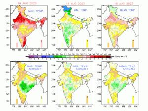 Even temperatures have spiked up above normal by 2 to 5 degrees in absence of rains[/caption] In the deccan Kerala is experiencing the worst monsoon ever, the total seasonal rainfall is recorded as 886.7 mm against the normal of 1616.4 mm the departure from normal stands at -45 per cent, it is likely to be the driest monsoon ever in the history of Kerala as on paper 40 days are left for the season and no recovery is in foresight, this season Telangana has emerged out to be the best performing state with a total of 593.1 mm against the average of 493.4 mm, the departure from normal is +25 per cent all thanks to the favourable tracks of low pressure area this year. [caption id=“attachment_13019992” align=“alignnone” width=“715”]
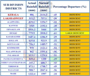 District wise seasonal rainfall in kerala, some districts have experienced rainfall deficiency by more than -50 per cent till 19 August[/caption] August monthly rainfall is currently trending at the historical lowest ever for India, the -36 per cent departure from normal is projected to be -40 to -42 per cent by the month end making it the driest August ever recorded, the previous lowest ever was -25 per cent departure in the year of 2005 one of the season with drought in the country. A few weeks back India’s rainfall statistics marked July 2023 as one of the wettest on record now August turns out to be exactly opposite, the extreme seasonal variability along with regional rainfall distribution continues to surprise with each passing year, this also validates how strongly El Nino dominates the Indian monsoon if other supportive parameters lacks, although science is getting better - numerical models are capturing the trends way better in mid to long range. When one talk about regional rainfall distribution this is how it is impacting, while the many parts of north west India plains are experiencing dry and hot weather conditions for past two weeks the axis of monsoon stuck over the Himalayas have caused record breaking rains in parts of Uttarakhand and Himachal Pradesh in the past week. Rainfall in some major towns of Uttarakhand in August 2023 so far: Rishikesh: 1621.2 mm Narendranagar: 1401.0 mm Sahastradhara: 1132.0 mm Kathgodam: 1017.0 mm Shama: 964.0 mm Kotdwar: 843.0 mm Loharkhet: 790.0 mm Tanakpur: 761.0 mm Dehradun: 563.4 mm As on 19th August, the seasonal rainfall over pan India stands at an actual of 573.2 mm against the normal of 611.8 mm the departure from normal stands at -6 per cent compared to week on week of -3 per cent, fell by 3 per cent. Subdivision wise seasonal rainfall in the period of 1st June till 19th August, 2023: • Southern Peninsula: Actual 426.1mm against the average of 488.6 mm, -13 per cent departure from normal. • East and North East India: Actual 772.4 mm against the average of 960.1 mm, -20 per cent departure from normal. • North West India: Actual 449.6 mm against the average of 420.9 mm, +7 per cent departure from normal. • Central India: Actual 677.6 mm against the average of 693.1 mm, -2 per cent departure from normal. [caption id=“attachment_13020002” align=“alignnone” width=“580”]
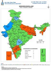 Current seasonal rainfall in the subdivisions of the country till 19 August 2023[/caption] Current synoptic weather features influencing weather in India as on 20 August, 2023: • The Low Pressure Area over northeast Madhya Pradesh and neighbourhood with the associated cyclonic circulation extending up to 5.8 km above mean sea level tilting southwards with height persists. It is likely to move west-northwest wards across central parts of north Madhya Pradesh during next 12 hours. • The Monsoon Trough at mean sea level now passes through Jaisalmer, Kota, Guna, centre of Low Pressure Area over northeast Madhya Pradesh, Daltonganj, Digha and hence east-southeastwards to northeast Bay of Bengal extending up to 1.5 km above mean sea level. • The Western Disturbance as a trough in middle tropospheric westerlies with its axis at 5.8 km above mean sea level roughly along Long. 72°E to the north of Lat. 32°N persists. • The cyclonic circulation over central Pakistan at 1.5 km above mean sea level persists. All India weather forecast till 27 August: The monsoon revived over parts of central and west India over the weekend under the influence of the low pressure area however the circulation is getting weak and likely to dissipate on Monday, under such conditions the monsoon axis will once again start shifting towards the foothills of Himalayas, while moving upwards it may impact plains of north west India early next week but remaining parts of country will once again see subdued rains in the upcoming week. States to experience normal rainfall till 27 August: • Madhya Pradesh, Chhattisgarh, Odisha, Jharkhand, West Bengal, Uttar Pradesh, Uttarakhand, Bihar to observe moderate to heavy rains in the upcoming week as the eastern arm of the monsoon axis will remain close to the foothills. States to experience above normal rains till 27th August: • As the monsoon axis shifts northwards the flow of moist southerlies resume from the bay of bengal towards north east India and help increase rainfall activities over the seven sister states. Moderate to heavy rains will occur in Sikkim, Meghalaya, Mizoram, Manipur, Nagaland, Tripura, Mizoram, Arunachal Pradesh with possibility of very heavy rains for a few days. States to experience below normal rains: •As the monsoon axis moves north, moderate rains will occur over parts of Punjab, Haryana, Delhi NCR, Himachal Pradesh, Jammu and Kashmir during 21 till 23 August but mainly dry weather will be observed for remaining days of the week hence may end the week on a below normal note. Subdued rainfall is projected for Gujarat, Maharashtra, Telangana, Andhra Pradesh, Karnataka, Tamil Nadu, Kerala for the entire week and anomaly will further turn negative on pan India level. The seasonal anomaly of -6 per cent is threatening with expectations of poor monsoon performance in the remaining days of the month; this number might get close to -10 per cent by August end. Climatology wise September rainfall average has been low when compared to July and August, Also the impact of El Nino is dominating this is overall red flag for monsoon rains for the remaining days of the season, also normally monsoon starts withdrawing from north west India around 17 September, if pan India rainfall departure would be -10 per cent or more certain parts of the country will be facing drought. The writer, better known as the Rohtak Weatherman, interprets and explains complex weather patterns. His impact-based forecasts @navdeepdahiya55 are very popular in north India. Views expressed in the above piece are personal and solely that of the author. They do not necessarily reflect Firstpost_’s views._ Read all the
Latest News
,
Trending News
,
Cricket News
,
Bollywood News
, India News
and
Entertainment News
here. Follow us on
Facebook
,
Twitter
and
Instagram
.
Current seasonal rainfall in the subdivisions of the country till 19 August 2023[/caption] Current synoptic weather features influencing weather in India as on 20 August, 2023: • The Low Pressure Area over northeast Madhya Pradesh and neighbourhood with the associated cyclonic circulation extending up to 5.8 km above mean sea level tilting southwards with height persists. It is likely to move west-northwest wards across central parts of north Madhya Pradesh during next 12 hours. • The Monsoon Trough at mean sea level now passes through Jaisalmer, Kota, Guna, centre of Low Pressure Area over northeast Madhya Pradesh, Daltonganj, Digha and hence east-southeastwards to northeast Bay of Bengal extending up to 1.5 km above mean sea level. • The Western Disturbance as a trough in middle tropospheric westerlies with its axis at 5.8 km above mean sea level roughly along Long. 72°E to the north of Lat. 32°N persists. • The cyclonic circulation over central Pakistan at 1.5 km above mean sea level persists. All India weather forecast till 27 August: The monsoon revived over parts of central and west India over the weekend under the influence of the low pressure area however the circulation is getting weak and likely to dissipate on Monday, under such conditions the monsoon axis will once again start shifting towards the foothills of Himalayas, while moving upwards it may impact plains of north west India early next week but remaining parts of country will once again see subdued rains in the upcoming week. States to experience normal rainfall till 27 August: • Madhya Pradesh, Chhattisgarh, Odisha, Jharkhand, West Bengal, Uttar Pradesh, Uttarakhand, Bihar to observe moderate to heavy rains in the upcoming week as the eastern arm of the monsoon axis will remain close to the foothills. States to experience above normal rains till 27th August: • As the monsoon axis shifts northwards the flow of moist southerlies resume from the bay of bengal towards north east India and help increase rainfall activities over the seven sister states. Moderate to heavy rains will occur in Sikkim, Meghalaya, Mizoram, Manipur, Nagaland, Tripura, Mizoram, Arunachal Pradesh with possibility of very heavy rains for a few days. States to experience below normal rains: •As the monsoon axis moves north, moderate rains will occur over parts of Punjab, Haryana, Delhi NCR, Himachal Pradesh, Jammu and Kashmir during 21 till 23 August but mainly dry weather will be observed for remaining days of the week hence may end the week on a below normal note. Subdued rainfall is projected for Gujarat, Maharashtra, Telangana, Andhra Pradesh, Karnataka, Tamil Nadu, Kerala for the entire week and anomaly will further turn negative on pan India level. The seasonal anomaly of -6 per cent is threatening with expectations of poor monsoon performance in the remaining days of the month; this number might get close to -10 per cent by August end. Climatology wise September rainfall average has been low when compared to July and August, Also the impact of El Nino is dominating this is overall red flag for monsoon rains for the remaining days of the season, also normally monsoon starts withdrawing from north west India around 17 September, if pan India rainfall departure would be -10 per cent or more certain parts of the country will be facing drought. The writer, better known as the Rohtak Weatherman, interprets and explains complex weather patterns. His impact-based forecasts @navdeepdahiya55 are very popular in north India. Views expressed in the above piece are personal and solely that of the author. They do not necessarily reflect Firstpost_’s views._ Read all the
Latest News
,
Trending News
,
Cricket News
,
Bollywood News
, India News
and
Entertainment News
here. Follow us on
Facebook
,
Twitter
and
Instagram
.
Weather Report: Monsoon break wreaks havoc, but east and central India to have rains this week
Navdeep Dahiya
• August 21, 2023, 12:00:44 IST
Madhya Pradesh, Chhattisgarh, Odisha, Jharkhand, West Bengal, Uttar Pradesh, Uttarakhand, Bihar to observe moderate to heavy rains in this week as the eastern arm of the monsoon axis will remain close to the foothills
Advertisement
 "Weather Report: Monsoon break wreaks havoc, but east and central India to have rains this week")
End of Article