A western disturbance resulted in the season’s first proper snowfall event in the western Himalayas earlier in the past week. The plains of North India experienced thunderstorms and rains as the weather system moved away and paved the way for cool northwest winds. Temperatures started falling in the hills as well as the plains, setting in the proper autumn chill. Minimum temperature across Uttarakhand and Himachal Pradesh on 18 October, 2023: Uttarakhand Kedarnath -1.0°C Badrinath 1.2°C Harsil 1.9°C Janki Chatti 2.0°C Mukteshwar 5.6°C Chakrata 7.0°C Pithoragarh 8.0°C Joshimath 8.1°C Pauri 8.6°C Mussoorie 8.6°C Almora 9.0°C Tharali 9.3°C Tehri 9.4°C Ukhimath 9.6°C Uttarkashi 9.7°C Himachal Pradesh Keylong -2.4°C Kalpa 0.8°C Sumdo 2.2°C Manali 3.2°C Reckong Peo 3.9°C Narkanda 4.1°C Dalhousie 5.7°C Bhuntar 6.1°C Sainj 7.4°C Sundernagar 7.9°C Nauni 8.2°C Mandi 8.9°C Shimla 9.0°C Minimum temperature across Jammu, Kashmir and Ladakh on 19 October, 2023: Hanle -7.2°c Nyoma -4.6°c Drass -3.5°c Leh -2.0°c Gulmarg -1.3°c Pahalgam -0.6°c Sonamarg -0.4°c Shopian -0.3°c Bandipora 2.5°c Kupwara 2.7°c Srinagar 4.7°c Bhaderwah 4.9°c Banihal 6.5°c Qazi Gund 7.4°c Katra 11.8°c Jammu 13.3°c [caption id=“attachment_13284532” align=“alignnone” width=“640”]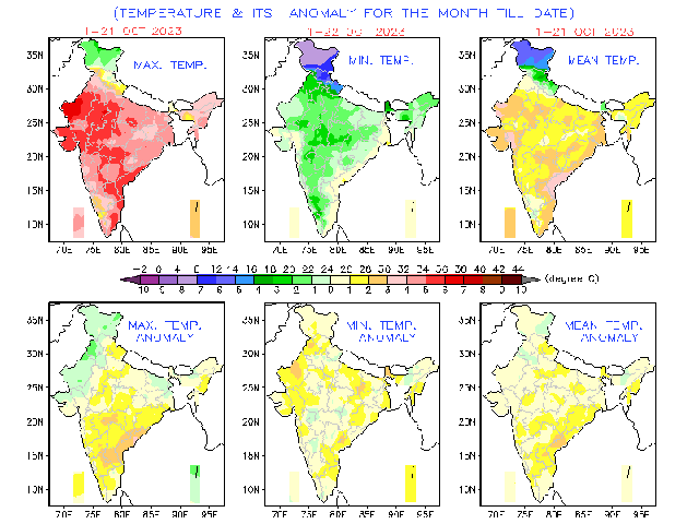 Temperature anomaly during the month of October so far[/caption] Northeast monsoon sets in over the southern parts of India as the southwest monsoon withdraws from entire India on Saturday. In association with the well-marked Low-Pressure Area over the Southeast and adjoining Central Bay of Bengal and a cyclonic circulation over the Comorin Area, northeasterly winds have strengthened over the South and Central Bay of Bengal, extending up to the middle tropospheric levels. Despite the monsoon onset, the rainfall performance in Chennai has been pretty poor so far this month. Nungambakkam with 86mm and Meenabakkam with 39mm are heading towards the lowest October rainfall since 2016 and the city witnessed only 22mm of rainfall in the entire month of October in 2016. The pan-India actual rainfall so far in the period from the 1 to 22 October stands at 47.5mm against the normal of 61.2mm with the departure from normal currently standing at -22%. Subdivision-wise seasonal rains till 2 October: Southern Peninsula: Actual 49.7mm against the average of 111.5mm, with a -55% departure from normal. East and North East India: Actual 129.4mm against the average of 107mm, with a +21% departure from normal. North West India: Actual 30.9mm against the average of 19.3mm, with a +60% departure from normal. Central India: Actual 22.6mm against the average of 48.6mm, with a -54% departure from normal. [caption id=“attachment_13284652” align=“alignnone” width=“640”]
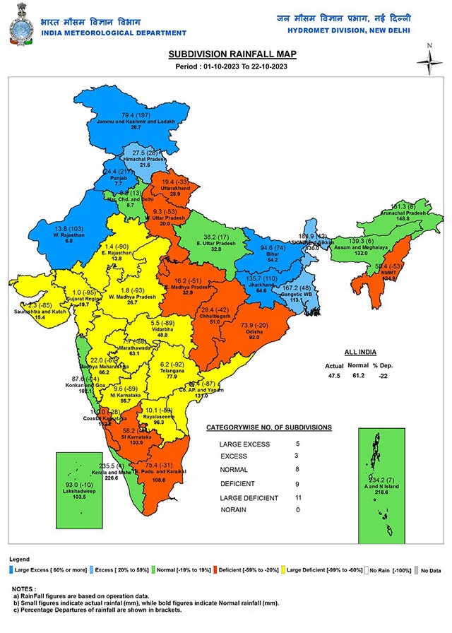 Seasonal rainfall in India from 1 to 15 October, 2023[/caption] Twin cyclones in the Indian Ocean • The Extremely Severe Cyclonic Storm “Tej” (pronounced as Tej) over west central and adjoining southwest Arabian moved northwestwards with a speed of 18 kmph during past six hours and lay centred at 1730 hours on 22 October over west central Arabian Sea, near latitude 13.3°N and longitude 54.4°E about 90 km north-northeast of Socotra (Yemen), 410 km south of Salalah (Oman) and 390 km southeast of Al Ghaidah (Yemen). It is very likely to move northwestwards and cross Yemen coast close to Al Ghaidah (Yemen) around the early hours of 24 October as a very severe cyclonic storm with a wind speed of 125-135 kmph gusting to 150 kmph. • The Depression over west-central Bay of Bengal moved nearly northwards with a speed of 17 kmph during past six hours, intensified into a deep depression and lay centred at 1730 hours IST of today, the 22 October over the same region, near latitude 16.2°N and longitude 86.4°E about 450 km south of Paradip (Odisha), 560 km south-southwest of Digha (West Bengal), and 750 km south-southwest of Khepupara (Bangladesh). It is likely to intensify further into a cyclonic storm during the next 24 hours. It is likely to move nearly northwards till the morning of 23 October, then north-northeast wards and cross the Bangladesh coast between Khepupara and Chittagong around the 25 October evening as a deep depression. As per the data from the Joint Typhoon Warning Center, with a wind speed of 105 knots, Cyclone Tej is jointly the 5th strongest post-monsoon season cyclone in the Arabian Sea. Top 5 strongest cyclones in the Arabian Sea since the satellite era: 1. Kyarr: 135 knots 2. Chapala: 130 knots 3. Nilofar: 115 knots 4. Megh: 110 knots 5. Maha & Tej: 105 knots [caption id=“attachment_13284682” align=“alignnone” width=“640”]
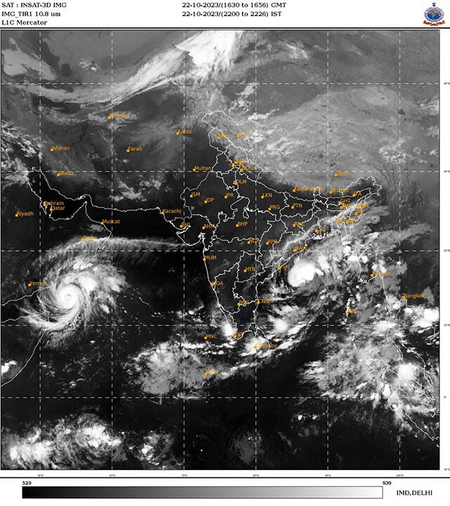 Satellite imagery from 22 October shows twin cyclones in Arabian Sea and Bay of Bengal[/caption] All India weather forecast till 29 October, 2023 Twin cyclone tracks are not projected to be heading India’s way, both the west and east coast of India are likely to be landfall-free, Cyclone Tej in the Arabian Sea is likely to head towards Oman and make landfall, Cyclone Hamoon in the Bay of Bengal will recurve northeast and head back in the sea towards Bangladesh. Nevertheless, the bay cyclone will have some impact at the east coast of India as outer bands of the system will move brushing coastal towns and cities of Odisha and West Bengal. Moderate rains are expected in various parts along with sustained wind gust up to 30km/h, Kolkata might celebrate Navami and Dussehra on a wet and windy note. [caption id=“attachment_13284812” align=“alignnone” width=“640”]
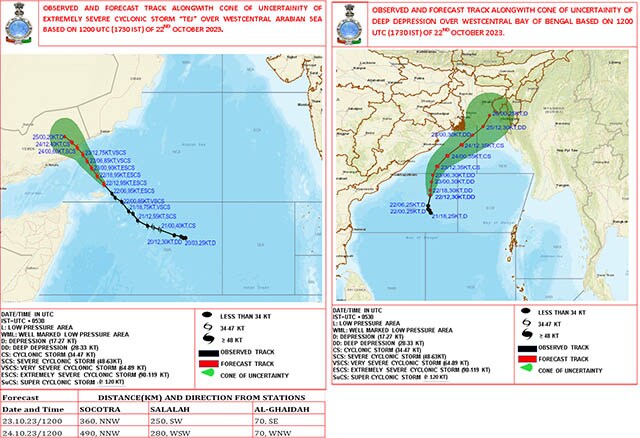 Expected track of twin cyclones as per Indian meteorological department[/caption] The northeast monsoon made a weak onset over Tamil Nadu and Kerala. The upcoming week until 29 October will not bring any significant rains over Chennai and north Tamil Nadu the conditions will continue to stay poor in terms of monsoon rains, however, multiple cities of Kerala and the south interiors of Tamil Nadu to experience moderate to heavy rains during evening till late night hours on a daily basis in the entire week, except Kerala all other states in the country would observe below normal rains in the upcoming week. This week western disturbances are likely to take a short break in North India hence absolute dry weather conditions are expected to prevail in Jammu, Kashmir, Ladakh, Himachal Pradesh, Uttarakhand, Punjab, Haryana, Chandigarh, Rajasthan, Uttar Pradesh, Gujarat, Maharashtra, Karnataka, Goa, Andhra Pradesh, Telangana, Madhya Pradesh, Chhattisgarh, Jharkhand, Bihar, West Bengal, Sikkim, Arunachal Pradesh, Assam, Meghalaya, Mizoram, Manipur, Nagaland and Tripura. Cool northwest winds and clear skies at night will lead to a fall in minimum temperature by 2 to 3°c, various cities in the states and UTs to experience a minimum temperature in the range of 11 to 16°c, this will mark the beginning of mild winters at least in nights, the drop in day temperatures are yet to be recorded but October heat will taper down climatologically as we are in the last week of the month. The writer, better known as the Rohtak Weatherman, interprets and explains complex weather patterns. His impact-based forecasts @navdeepdahiya55 are very popular in north India. Views expressed in the above piece are personal and solely that of the author. They do not necessarily reflect Firstpost_’s views._ Read all the
Latest News
,
Trending News
,
Cricket News
,
Bollywood News
, India News
and
Entertainment News
here. Follow us on
Facebook
,
Twitter
and
Instagram
.
Expected track of twin cyclones as per Indian meteorological department[/caption] The northeast monsoon made a weak onset over Tamil Nadu and Kerala. The upcoming week until 29 October will not bring any significant rains over Chennai and north Tamil Nadu the conditions will continue to stay poor in terms of monsoon rains, however, multiple cities of Kerala and the south interiors of Tamil Nadu to experience moderate to heavy rains during evening till late night hours on a daily basis in the entire week, except Kerala all other states in the country would observe below normal rains in the upcoming week. This week western disturbances are likely to take a short break in North India hence absolute dry weather conditions are expected to prevail in Jammu, Kashmir, Ladakh, Himachal Pradesh, Uttarakhand, Punjab, Haryana, Chandigarh, Rajasthan, Uttar Pradesh, Gujarat, Maharashtra, Karnataka, Goa, Andhra Pradesh, Telangana, Madhya Pradesh, Chhattisgarh, Jharkhand, Bihar, West Bengal, Sikkim, Arunachal Pradesh, Assam, Meghalaya, Mizoram, Manipur, Nagaland and Tripura. Cool northwest winds and clear skies at night will lead to a fall in minimum temperature by 2 to 3°c, various cities in the states and UTs to experience a minimum temperature in the range of 11 to 16°c, this will mark the beginning of mild winters at least in nights, the drop in day temperatures are yet to be recorded but October heat will taper down climatologically as we are in the last week of the month. The writer, better known as the Rohtak Weatherman, interprets and explains complex weather patterns. His impact-based forecasts @navdeepdahiya55 are very popular in north India. Views expressed in the above piece are personal and solely that of the author. They do not necessarily reflect Firstpost_’s views._ Read all the
Latest News
,
Trending News
,
Cricket News
,
Bollywood News
, India News
and
Entertainment News
here. Follow us on
Facebook
,
Twitter
and
Instagram
.
Weather report: Low rainfall in Tamil Nadu this week, Kerala set for monsoon showers; dry condition in rest of India
Navdeep Dahiya
• October 23, 2023, 11:15:45 IST
The upcoming week until 29 October will not bring any significant rains over Chennai and north Tamil Nadu the conditions will continue to stay poor in terms of monsoon rains
Advertisement
 "Weather report: Low rainfall in Tamil Nadu this week, Kerala set for monsoon showers; dry condition in rest of India")
End of Article