
 "Weather Report: Heat is on but it won't last long in north India, thunderstorms to hit southern states midweek")
In the past week heat is making its appearance felt in India after a relatively cool start of April, temperatures have increased significantly across North, East and Central parts of the country. On 13 April Delhi NCR region hit 40° C for the first time in this season. Four stations in the national capital recorded the first 40°C max temperature. While the base observatories, Safdarjung and IGI airport recorded 38.6°C and 39.2°C respectively but the heat continued to increase as both the stations recorded first 40 degrees with a maximum temperature of 40.5 degrees on 15 April. Along with the capital many more stations in Punjab, Haryana, Rajasthan and Uttar Pradesh followed the warming suit as stations started crossing the 40°C temperature and kick-off summers. [caption id=“attachment_12464242” align=“alignnone” width=“575”] The cooling period ends and as the summer starts the temperature anomaly is becoming above normal with the first spell of Heatwave[/caption] Since the weather conditions have been drier the past week, temperatures shoot up in the Himalayas. Maximum temperature recorded in stations of Himachal Pradesh, Uttarakhand and Kashmir on 14 April: Una: 36.8°C Pantnagar: 36.2°C Dehradun: 35.1°C Jammu: 34.6°C Mandi: 33.5°C Sundernagar: 32.4°C Bhuntar: 31.4°C Solan: 30.0°C Dharamshala: 29.0°C Srinagar: 27.2°C Pauri: 25.7°C Mukteshwar: 25.3°C Tehri: 25.3°C Manali: 23.8°C Mussoorie: 23.7°C Shimla: 23.5°C Gulmarg: 16.8°C It’s turning hot in the North while the Eastern parts of the country along with adjoining Central India have experienced the first spell of heatwave in the past 3 days as dry and sizzling hot winds brought a significant upward trend in temperatures. Top 10 hottest stations in India on 14 April (most stations are from East and Central states): • Baripada (Odisha): 44.0°C • Panagarh (West Bengal): 42.9°C • Jharsuguda (Odisha): 42.8°C • Chandrapur (Maharashtra): 42.8°C • Bankura (West Bengal): 42.7°C • Prayagraj (Uttar Pradesh): 42.6°C • Nandigama (Andhra Pradesh): 42.6°C • Talcher (Odisha): 42.6°C • Boudh (Odisha): 42.5°C • Titilagarh (Odisha): 42.5°C Followed by the top 10 hottest places in India on Saturday when northern states joined the league: • Prayagraj (Uttar Pradesh): 44.2°C • Ganganagar (Rajasthan): 43.5°C • Churu (Rajasthan): 42.9°C • Dehri (Bihar): 42.8°C • Agra (Uttar Pradesh): 42.6°C • Jhansi (Uttar Pradesh): 42.6°C • Rajgarh (Madhya Pradesh): 42.5°C • Boudh (Odisha): 42.5°C • Hamirpur (Uttar Pradesh): 42.2°C • Jharsuguda (Odisha): 42.2°C The heat has wrapped up the various regions in the country but Maharashtra and some parts of Karnataka have experienced thunderstorms and some record breaking rains. A thunderstorm hit Mumbai on the mid night of 13 April with a highest wind gust of 83 km/h which is incredibly high for a the west coast also accumulated 14.6 mm rainfall at the Santa Cruz observatory, this is highest ever single day and monthly rainfall for Santa Cruz in month of April breaking the previous single day record of 7.2 mm which was set on 22nd April 1974 and the monthly record of 9.2 mm from April 1974. [caption id=“attachment_12464272” align=“alignnone” width=“593”]
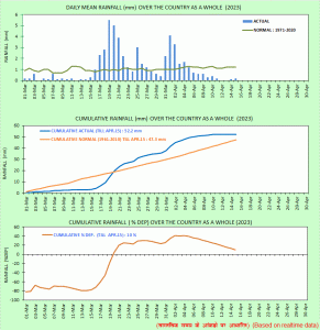 The curve of cumulative rainfall percentage sees a sharp dip as dry weather conditions dominated India except some western states[/caption] Except western India most parts of the country did not receive any significant precipitation in the past week. The rainfall metrics for the pre monsoon season have started to curve downwards. In the period of 1 March till 15 April the country as a whole recorded 52.2 mm rainfall against the normal of 47.3 mm, departure from normal stands at +10 per cent fell from +28 per cent during the last Sunday. Subdivision-wise seasonal rainfall in the period of 1 March - 15 April, 2023: • Southern Peninsula: Actual 41.6 mm against the average of 29.3 mm, +42 per cent departure from normal. • East & North East India: Actual 97.4 mm against the average of 112.9 mm, -14 per cent departure from normal. • North West India: Actual 57.1 mm against the average of 63.9 mm, -11 per cent departure from normal. • Central India: Actual 32.6mm against the average of 11.7mm, +179 per cent departure from normal. [caption id=“attachment_12464292” align=“alignnone” width=“598”]
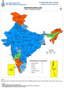 The pre monsoon seasonal rainfall map continue to look attractively blue due to the excessive rainfall in the month of March and early April[/caption] Current synoptic features influencing weather in India as on 15th April • The Western Disturbance is a trough in mid & upper tropospheric westerlies with its axis at 5.8 km above mean sea level roughly along Longitude 56°E to the North of Latitude 28°N persists. • The cyclonic circulation over SouthWest Rajasthan & neighbourhood between 1.5 and 3.1 km above mean sea level persists. • The cyclonic circulation over Northwest Madhya Pradesh and neighbourhood at 0.9 km above mean sea level persists. • The trough/wind discontinuity from northeast Jharkhand to Tamil Nadu across Odisha and Andhra Pradesh at 0.9 km above mean sea level persists. • The cyclonic circulation over Northeast Bangladesh and neighbourhood extending up to 0.9 km above mean sea level persists. All India weather forecast till 22 April, 2023 North India: “The heat is on but it won’t last long” - Day time temperature rose significantly along with heatwave conditions are observed over various parts in Uttar Pradesh, Delhi NCR, Rajasthan, Haryana and Punjab since the maximum temperature is recorded above 40°c and departure from normal is 4 to 6°C above normal in most stations, the heatwave like conditions are expected to persist till Tuesday afternoon as hot winds will continue to reel. Under the influence of an approaching western disturbance cloudy weather, Dust storm, thundershowers to return in the region during later half of 18 April and might last up to 20 April night bringing in respite from hot weather as a brief spell of summer storms may bring in drastic drop in day temperature on Wednesday and Thursday but the weather conditions will become dry in the plains once again over the next weekend. Foreseeing the activeness of the western disturbance moderate to heavy rains are expected in the lower Himalayan ranges along with high probability of hailstorm and lightning strikes whereas higher reaches in Kashmir, Himachal Pradesh, Uttarakhand to experience spell of heavy snowfall during 18 to 20 April along with below normal temperatures. East India and North East India: The weather conditions are expected to remain hot in most parts of Bihar, Jharkhand, West Bengal, Odisha during the upcoming week with heatwave condition to persist in some stations of the region since the maximum temperature is expected in the range of 42 to 45°C, although the weather conditions would remain dry in most parts until Thursday, some thunderstorm and rains are indicated around next weekend which may bring slight respite from the ongoing heatwave depending on the extent of the rainfall. Most parts in the North-East has been experiencing dry pre monsoon season, now an anti-cyclonic circulation in the bay of Bengal will push moist southern winds towards the seven sister states as a result a significant increase in rainfall is expected over Arunachal Pradesh, Assam, Sikkim, Meghalaya, Mizoram, Tripura, Nagaland and Manipur during 19 to 22 April, normally by this time of the year it usually starts to get wet weather in the North-East states. Central India “The unprecedented unseasonal rains to dominate” - The streak of rains and thunderstorm seems to be never ending this year, the wind discontinuity will persist around Maharashtra in the upcoming week and likely to strengthen further during 18 to 21 April due to the interaction with the approaching western disturbance and an induced cyclonic circulation over East Madhya Pradesh. The synoptic weather features will result in fairly widespread rainfall over Maharashtra, Chhattisgarh and Madhya Pradesh during 18 to 21 April and bring in some level of cooling in the atmosphere due to cloudy and wet weather, overall temperature anomaly will be below normal across these states. Though Gujarat will not come under any of this weather blanket and is likely to experience dry and hot weather conditions with maximum temperatures in the range of 38 to 42°C in this week. South India Summer is yet to reach its peak in the peninsula but it has started to get very hot in Andhra Pradesh, Telangana, Tamil Nadu in the past week as the maximum temperatures are recorded in the range of 40 to 44°C. The thunderstorm season commonly known as Mango showers has been delayed this year in Kerala and interiors of Karnataka, statistically both the sub divisions are experiencing below normal precipitation so far as rains usually start early in April. It is likely to stay warm and dry till mid week in Kerala and Karnataka but the thunderstorm season is all set to onset in the region after 20 April as the weather charts indicate formation of wind convergence around this time. Moderate intensity rains and thunderstorms are expected in Kerala, Tamil Nadu, Karnataka and Telangana during 20 to 22 April in this week. The convective clouds usually develop in the late afternoon to evening hours and are accompanied with lightning strikes and strong winds, this means the afternoon hours are still likely to be hot and muggy over the southern states with a higher heat index as the humidity will also be on a higher side. The author, better known as the Rohtak Weatherman, interprets and explains complex weather patterns. His impact-based forecasts @navdeepdahiya55 are very popular in north India. Read all the
Latest News ,
Trending News ,
Cricket News ,
Bollywood News , India News and
Entertainment News here. Follow us on
Facebook,
Twitter and
Instagram.
The pre monsoon seasonal rainfall map continue to look attractively blue due to the excessive rainfall in the month of March and early April[/caption] Current synoptic features influencing weather in India as on 15th April • The Western Disturbance is a trough in mid & upper tropospheric westerlies with its axis at 5.8 km above mean sea level roughly along Longitude 56°E to the North of Latitude 28°N persists. • The cyclonic circulation over SouthWest Rajasthan & neighbourhood between 1.5 and 3.1 km above mean sea level persists. • The cyclonic circulation over Northwest Madhya Pradesh and neighbourhood at 0.9 km above mean sea level persists. • The trough/wind discontinuity from northeast Jharkhand to Tamil Nadu across Odisha and Andhra Pradesh at 0.9 km above mean sea level persists. • The cyclonic circulation over Northeast Bangladesh and neighbourhood extending up to 0.9 km above mean sea level persists. All India weather forecast till 22 April, 2023 North India: “The heat is on but it won’t last long” - Day time temperature rose significantly along with heatwave conditions are observed over various parts in Uttar Pradesh, Delhi NCR, Rajasthan, Haryana and Punjab since the maximum temperature is recorded above 40°c and departure from normal is 4 to 6°C above normal in most stations, the heatwave like conditions are expected to persist till Tuesday afternoon as hot winds will continue to reel. Under the influence of an approaching western disturbance cloudy weather, Dust storm, thundershowers to return in the region during later half of 18 April and might last up to 20 April night bringing in respite from hot weather as a brief spell of summer storms may bring in drastic drop in day temperature on Wednesday and Thursday but the weather conditions will become dry in the plains once again over the next weekend. Foreseeing the activeness of the western disturbance moderate to heavy rains are expected in the lower Himalayan ranges along with high probability of hailstorm and lightning strikes whereas higher reaches in Kashmir, Himachal Pradesh, Uttarakhand to experience spell of heavy snowfall during 18 to 20 April along with below normal temperatures. East India and North East India: The weather conditions are expected to remain hot in most parts of Bihar, Jharkhand, West Bengal, Odisha during the upcoming week with heatwave condition to persist in some stations of the region since the maximum temperature is expected in the range of 42 to 45°C, although the weather conditions would remain dry in most parts until Thursday, some thunderstorm and rains are indicated around next weekend which may bring slight respite from the ongoing heatwave depending on the extent of the rainfall. Most parts in the North-East has been experiencing dry pre monsoon season, now an anti-cyclonic circulation in the bay of Bengal will push moist southern winds towards the seven sister states as a result a significant increase in rainfall is expected over Arunachal Pradesh, Assam, Sikkim, Meghalaya, Mizoram, Tripura, Nagaland and Manipur during 19 to 22 April, normally by this time of the year it usually starts to get wet weather in the North-East states. Central India “The unprecedented unseasonal rains to dominate” - The streak of rains and thunderstorm seems to be never ending this year, the wind discontinuity will persist around Maharashtra in the upcoming week and likely to strengthen further during 18 to 21 April due to the interaction with the approaching western disturbance and an induced cyclonic circulation over East Madhya Pradesh. The synoptic weather features will result in fairly widespread rainfall over Maharashtra, Chhattisgarh and Madhya Pradesh during 18 to 21 April and bring in some level of cooling in the atmosphere due to cloudy and wet weather, overall temperature anomaly will be below normal across these states. Though Gujarat will not come under any of this weather blanket and is likely to experience dry and hot weather conditions with maximum temperatures in the range of 38 to 42°C in this week. South India Summer is yet to reach its peak in the peninsula but it has started to get very hot in Andhra Pradesh, Telangana, Tamil Nadu in the past week as the maximum temperatures are recorded in the range of 40 to 44°C. The thunderstorm season commonly known as Mango showers has been delayed this year in Kerala and interiors of Karnataka, statistically both the sub divisions are experiencing below normal precipitation so far as rains usually start early in April. It is likely to stay warm and dry till mid week in Kerala and Karnataka but the thunderstorm season is all set to onset in the region after 20 April as the weather charts indicate formation of wind convergence around this time. Moderate intensity rains and thunderstorms are expected in Kerala, Tamil Nadu, Karnataka and Telangana during 20 to 22 April in this week. The convective clouds usually develop in the late afternoon to evening hours and are accompanied with lightning strikes and strong winds, this means the afternoon hours are still likely to be hot and muggy over the southern states with a higher heat index as the humidity will also be on a higher side. The author, better known as the Rohtak Weatherman, interprets and explains complex weather patterns. His impact-based forecasts @navdeepdahiya55 are very popular in north India. Read all the
Latest News ,
Trending News ,
Cricket News ,
Bollywood News , India News and
Entertainment News here. Follow us on
Facebook,
Twitter and
Instagram.
Cloudy weather, dust storms, thundershowers may return to north India between Tuesday and Thursday. Moderate intensity rains and thunderstorms are expected in Kerala, Tamil Nadu, Karnataka and Telangana during 20 to 22 April
Advertisement
End of Article

 "Russian drones over Poland: Trump’s tepid reaction a wake-up call for Nato?")
 "As Russia pushes east, Ukraine faces mounting pressure to defend its heartland")
 "Why Mossad was not on board with Israel’s strike on Hamas in Qatar")
 "Turkey: Erdogan's police arrest opposition mayor Hasan Mutlu, dozens officials in corruption probe")


