
 "Weather report: East India to remain relatively dry; heatwave to comeback in Haryana, Delhi by the weekend")
The western disturbance, seen playing on the front foot this year, has played spoilsport in the finale of the 16th season of the Indian Premier League. The heavy rainfall in Ahmedabad is surprising as the monthly average for the city is just 7 mm in the month of May, nevertheless this is how it has been in this pre-monsoon season as western disturbances are quite frequent and dipping more south then normal off late. Dark clouds hovering over the reserve day? The morning on 29th May is expected to start with a clear sky with bright sunshine, as the western disturbance induced convergence is still active over Gujarat it might result in a formation of scattered thunderstorms in northern parts of Gujarat as well as Ahmedabad during late afternoon to night hours, though the spells are expected to be shorter duration today as atmosphere is better stable today while compared to yesterday as most of the energy is released. The Match is expected for sure today even if it rains for sometime, indeed a good news for the cricket fans across the world. The summer month of May is about to end and surprisingly heatwave remained absent in India during the entire past week. Western disturbance remained active, The dominating weather system brought intense thunderstorms, squall, hailstorm, moderate to heavy rains across north, central and eastern parts of the country, the maximum and minimum temperatures remained significantly below normal by -5°c and up to -13°c. [caption id=“attachment_12664882” align=“alignnone” width=“411”] Seasonal temperatures have been below normal in the period of March to May so far[/caption] Wind gusts in the dust storms have been extreme, Jaipur Airport experienced maximum wind gusts of 96 km/h around 11 pm on 25 May. On Saturday early morning Delhi Airport clocked a whopping maximum wind gust of 102 km/h. These are the days when Rajasthan sees the highest temperature and remains unbearably hot but this time Ironically state has observed most extreme storms in the past 5 days, the prolonged spells of rains and Hailstorm are causing a lot of damage to life and property in the state. On Sunday a very intense storm swept across west and central Rajasthan with major impact on the Thar desert, Bikaner recorded 73 mm rainfall till 5:30 pm on Sunday breaking the all time record of heaviest rainfall in the period of 24 hours during the month of May, previous record was of 63.1 mm from 23rd May, 1999, such heavy rainfall in the span of few hours resulted in flash flood situation in some pockets of Bikaner, Phalodi, Nagaur and Jodhpur districts of the state. Some single day rainfall figures from parts of north west India during last 5 days: Rainfall in the span of 24 hours ending 8:30 am on 25 May: Rajasthan Dhod (Sikar): 127 mm Bidasar (Churu): 120 mm Maulasar (Naguar): 105 mm Sujangarh (Churu): 100 mm Ladnu (Nagaur): 92 mm Dantaramgarh (Sikar): 70 mm Kuchaman (Nagaur): 69 mm Chandigarh: 18 mm Punjab Ballowal Saunkhri: 82 mm Balachaur: 71 mm HimachalPradesh Dharampur: 67 mm Kangra: 55 mm Uttarakhand Pandukeshwar: 61 mm Tiuni: 48 mm Jammu and Kashmir Batote: 42 mm Banihal: 27 mm Uttar Pradesh Bahraich: 34mm Fursatganj: 11mm Hardoi: 10mm Rainfall in the span of 24 hours ending 8:30 am on 26th May Rajasthan Makrana (Nagaur): 77 mm Kolayat (Bikaner): 73 mm Tordisagar (Tonk): 70 mm Jaipur WRD: 63 mm Sikar WRD: 63 mm Roopangarh (Ajmer): 57 mm Lunkaransar (Bikaner): 56 mm Parbatsar (Nagaur): 54mm Bonli (Sawai Madhopur): 50mm Pilani: 50mm Uttarakhand Kashipur: 53 mm Bhimtal: 45 mm Champawat: 35 mm Kathgodam: 35 mm HimachalPradesh Arki (Solan): 48 mm Jhandutta (Bilaspur): 37 mm Punjab Gurdaspur: 23 mm Chandigarh: 9 mm Haryana Mahendragarh: 29 mm Rewari: 23 mm UttarPradesh Varanasi: 20 mm Banda: 17 mm Fursatganj: 17 mm Lucknow: 10 mm Rainfall in the span of 24 hours ending 8:30 am on 27 May: Rajasthan Mandal (Bhilwara): 110 mm Rawatsar: 60 mm Fatehpur: 50 mm Taranagar: 50 mm Laxmangarh: 50 mm Haryana Rohtak: 45 mm Ganaur: 40 mm Rania: 40 mm Loharu: 30 mm Faridabad: 30 mm Dadri: 30 mm Hisar: 18 mm Narnaul: 15 mm Punjab Sangrur: 40 mm Barnala: 30 mm Faridkot: 9 mm Bathinda: 7 mm Delhi Ridge: 33 mm Palam: 19 mm Safdarjung: 16 mm UttarPradesh Churk: 14 mm Aligarh: 8 mm Why are western disturbances so frequent and intense this year? • During the days of La Nina to El Nino transition times or during El Nino years spring and summer western disturbances frequency have remained higher than normal due to Jet streams remaining south then normal for a longer period of time, this increases chances of above normal spring and pre-monsoon rains in north west India at the same time becomes a bane for monsoon in the northern parts of the country. • Whenever a western disturbance approaches it induces a cyclonic circulation over the landmass in plains which help in pulling off moisture from Arabian sea also from Bay of Bengal at times. This year the Sea Surface Temperature (SST) is very high in the sea, the warm and moist ocean winds are providing additional fuel to the western disturbance this is resulting in widespread severe weather events across north west India. The pre-monsoon period is about to end as we head towards May end. Also, monsoon season officially starts on paper work of the meteorological department from 1st June onwards. In the period of 1 March till 28 May, country as a whole received a total of 139.1 mm rainfall against the normal of 123.3 mm the departure from normal stands at +13 per cent which falls under normal category for India, however north west, central and southern India saw above normal to excess rains this pre-monsoon season. Subdivision wise seasonal rainfall till 28th May, 2023: • Southern Peninsula: Actual 156.4 mm against the average of 112.3 mm, +39 per cent departure from normal. • East and North East India: Actual 240.8 mm against the average of 350.4 mm, -31 per cent departure from normal. • North West India: Actual 139.0 mm against the average of 110.9 mm, +25 per cent departure from normal. • Central India: Actual 80.9 mm against the average of 33.4 mm, +142 per cent departure from normal. [caption id=“attachment_12664902” align=“alignnone” width=“431”]
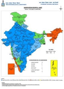 Seasonal rains so far in the sub divisions of India till 28th May, 2023[/caption] Current synoptic weather features influencing weather in India as on 29th May, 2023: • The Northern Limit of Southwest Monsoon continues to pass through 5°N/85°E, 6.5°N/90°E, Nancowry and 10°N/98°E. • Conditions are favourable for further advance of southwest monsoon into some more parts of south Bay of Bengal, Andaman Sea and Andaman & Nicobar Islands during next 24 hours. • A fresh Western Disturbance seen as a trough in middle and upper tropospheric westerlies with its axis at 5.8 km above mean sea level runs roughly along Long. 61°E to the north of Lat. 30°N. • The Western Disturbance as a cyclonic circulation over Himachal Pradesh and neighbourhood at 5.8 km above mean sea level persists. • The cyclonic circulation over southwest Rajasthan & adjoining Pakistan at 0.9 km above mean sea level persists. • The east-west trough from the above cyclonic circulation over southwest Rajasthan to northeast Madhya Pradesh across east Rajasthan at 0.9 km above mean sea level persists. • The cyclonic circulation over Telangana and neighbourhood at 0.9 km above mean sea level persists. • The north-south trough from southeast Madhya Pradesh to south Tamil Nadu across Vidarbha, cyclonic circulation over Telangana, Rayalaseema, north Tamil Nadu at 0.9 km above mean sea level persists. • The cyclonic circulation over northeast Bangladesh & adjoining Meghalaya extending up to 1.5 km above mean sea level persists. • The trough in mid tropospheric westerlies with its axis at 5.8 km above mean sea level roughly along Long. 86°E to the north of Lat. 18°N persists. [caption id=“attachment_12664912” align=“alignnone” width=“525”]
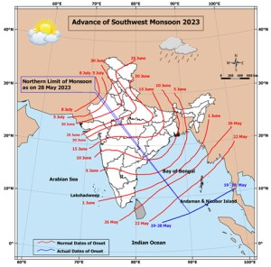 The northern limit of Monsoon till 28th May, 2023[/caption] The start of the upcoming week is expected to be wet over north west India along with below normal temperatures as western disturbance continues to impact. Later on heatwave is expected to make a comeback in Rajasthan, Gujarat, Haryana, Delhi NCR and Uttar Pradesh by the weekend as the rainy phase clears off. Under the influence of wind discontinuity, rains are expected to increase over southern peninsula states of Kerala, Tamil Nadu, Karnataka and Andhra Pradesh across this week. Most parts of east India specially Bihar, Jharkhand, West Bengal, Odisha, Chhattisgarh to experience a relatively dry week with hot weather as maximum temperature is expected in the range of 40°c to 44°c. The north eastern states will continue to receive on and off moderate to heavy rains across the week but a very significant spell is not seen in the near future as the Bay of Bengal branch of monsoon is expected to have a very slow start this year. The author, better known as the Rohtak Weatherman, interprets and explains complex weather patterns. His impact-based forecasts @navdeepdahiya55 are very popular in north India. Read all the
Latest News ,
Trending News ,
Cricket News ,
Bollywood News , India News and
Entertainment News here. Follow us on
Facebook,
Twitter and
Instagram.
The northern limit of Monsoon till 28th May, 2023[/caption] The start of the upcoming week is expected to be wet over north west India along with below normal temperatures as western disturbance continues to impact. Later on heatwave is expected to make a comeback in Rajasthan, Gujarat, Haryana, Delhi NCR and Uttar Pradesh by the weekend as the rainy phase clears off. Under the influence of wind discontinuity, rains are expected to increase over southern peninsula states of Kerala, Tamil Nadu, Karnataka and Andhra Pradesh across this week. Most parts of east India specially Bihar, Jharkhand, West Bengal, Odisha, Chhattisgarh to experience a relatively dry week with hot weather as maximum temperature is expected in the range of 40°c to 44°c. The north eastern states will continue to receive on and off moderate to heavy rains across the week but a very significant spell is not seen in the near future as the Bay of Bengal branch of monsoon is expected to have a very slow start this year. The author, better known as the Rohtak Weatherman, interprets and explains complex weather patterns. His impact-based forecasts @navdeepdahiya55 are very popular in north India. Read all the
Latest News ,
Trending News ,
Cricket News ,
Bollywood News , India News and
Entertainment News here. Follow us on
Facebook,
Twitter and
Instagram.
The north-eastern states will continue to receive on and off moderate to heavy rains across the week, but a very significant spell is not seen in the near future as the Bay of Bengal branch of the monsoon is expected to have a very slow start this year
Advertisement
End of Article

 "Russian drones over Poland: Trump’s tepid reaction a wake-up call for Nato?")
 "As Russia pushes east, Ukraine faces mounting pressure to defend its heartland")
 "Why Mossad was not on board with Israel’s strike on Hamas in Qatar")
 "Turkey: Erdogan's police arrest opposition mayor Hasan Mutlu, dozens officials in corruption probe")


