
 "Weather Report: East India braces for wet days ahead as Cyclone Michaung builds up; North India to remain dry")
The cyclonic storm Michaung has become the fourth cyclone of the year in the Indian Ocean. This is the highest number of weather systems spun in the Indian Ocean since 2019. Categorically, it is still a Category I cyclone and the third one to form in the Bay of Bengal in this post-monsoon season. The Cyclonic Storm “MICHAUNG” (pronounced as MIGJAUM) over the Southwest Bay of Bengal moved north-northwestwards with a speed of 8 km/h during the past 6 hours and lay centred at 2030 hours IST today, the 3rd of December 2023, over the same region near Latitude 12.4°N and Longitude 81.9°E, about 230 km east-northeast of Puducherry, 190 km east-southeast of Chennai, 310 km southeast of Nellore, 410 km south-southeast of Bapatla, and 430 km south-southeast of Machilipatnam. It is likely to continue to move north-northwestwards, intensify further, and reach the west-central Bay of Bengal off the south Andhra Pradesh and adjoining north Tamil Nadu coasts by 4 December forenoon. Thereafter, it would move nearly northwards, almost parallel and close to the south Andhra Pradesh coast, and cross the South Andhra Pradesh coast between Nellore and Machilipatnam during the forenoon of the 5th of December as a Severe Cyclonic Storm with a maximum sustained wind speed of 90-100 km/h, gusting to 110 km/h. [caption id=“attachment_13462302” align=“alignnone” width=“640”] Cyclone graphics, Michaung expected to make landfall over the Andhra Pradesh coast by 5 December[/caption] The pan-India actual rainfall from 1 October to 3 December stands at 89.4mm, compared to the normal of 106.5mm, resulting in a current deviation from the normal of -16%. The rainfall deficiency has improved by 10% week over week. Subdivision-wise seasonal rains as of 3 December 2023: • Southern Peninsula: Actual rainfall is 174.8mm against an average of 246.5mm, with a departure from normal at -29%. • East & North East India: Actual rainfall is 148.6mm against an average of 146.8mm, with a departure from normal at +1%. • North West India: Actual rainfall is 49.0mm against an average of 34.2mm, with a departure from normal at +43%. • Central India: Actual rainfall is 48.5mm against an average of 71.6mm, with a departure from normal at -32%. [caption id=“attachment_13462312” align=“alignnone” width=“640”]
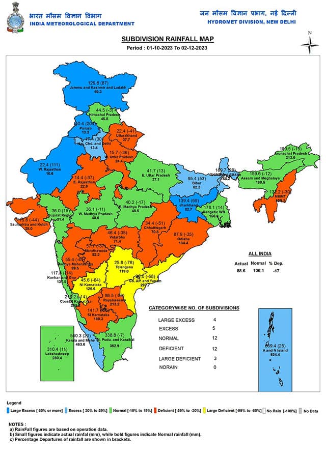 Subdivision-wise seasonal rainfall in India till 3 December 2023[/caption] A western disturbance earlier in the week affected the western Himalayas, parts of Punjab and Haryana, where fresh snowfall was recorded at the hill stations and moderate rains occurred in some parts of Punjab, Chandigarh and Haryana. As the weather system moved away, clear weather returned to the region, and night temperatures started falling. On 3 December, Nyoma in Ladakh recorded a minimum temperature of -16.7°C. In Himachal Pradesh, Keylong saw -7.0°C, followed by – Sumdo: -3.1°C Manali: 1.2°C Bhuntar AP: 2.1°C Reckong Peo: 2.9°C Narkanda: 3.5°C Sundernagar: 4.4°C Mandi: 5.1°C Una: 6.2°C Shimla: 6.2°C Kangra: 6.5°C. These were the coldest stations in Uttarakhand on Sunday: Gangotri: -6.0°C Harshil: -1.9°C Garud: 3.5°C More: 4.0°C Mukteshwar: 5.2°C Tehri: 5.4°C Pithoragarh: 5.5°C Joshimath: 5.7°C Chamoli: 6.4°C Mussoorie at 7.2°C Pauri at 8.0°C Nainital at 8.9°C Pantnagar at 9.1°C Dehradun at 9.8°C Current synoptic weather features influencing weather in India as of the morning of 4 December: The Cyclonic Storm “MICHAUNG” over the Southwest Bay of Bengal moved north-northwestwards with a speed of 8 km/h during the past 6 hours and lay centred at 1730 hours IST on 3 December 2023, over the same region near Latitude 12.2°N and Longitude 82.0°E, about 240 km east-northeast of Puducherry, 210 km east-southeast of Chennai, 330 km southeast of Nellore, 440 km south-southeast of Bapatla and 450 km south-southeast of Machilipatnam. It is likely to continue to move north-northwestwards, intensify further, and reach the West-central Bay of Bengal off south Andhra Pradesh and adjoining north Tamil Nadu coasts by 4 December forenoon. Thereafter, it would move nearly northwards, almost parallel and close to the south Andhra Pradesh coast and cross the South Andhra Pradesh coast between Nellore and Machilipatnam during the forenoon of December 5th as a Severe Cyclonic Storm with a maximum sustained wind speed of 90-100 km/h gusting to 110 km/h. The Western Disturbance, as a cyclonic circulation over Central Pakistan and a neighbourhood between 3.1 & 4.5 km above mean sea level with a trough aloft now runs roughly along Long. 67°E to the north of Lat. 30°N at 5.8 km above mean sea level. The cyclonic circulation over West Uttar Pradesh and the neighbourhood at 1.5 km above mean sea level persists. The Cyclonic Circulation over south Assam and the neighbourhood at 1.5 km above mean sea level persists. The Cyclonic Circulation over the east-central Arabian Sea between 1.5 & 3.1 km above mean sea level persists. All India weather forecast until 10 December: Southern parts of India are likely to face the brunt of Cyclone Michaung as extreme rains lash North Tamil Nadu, Chennai and Andhra Pradesh on Monday and Tuesday. Chennai recorded a massive 230.2mm ending at 8:30 am on 4 December. The possibility of adding another 100-200mm in 24 hours will lead to flooding in the city. As the cyclone is all set to make landfall near Machilipatnam on the morning of 5 December, various parts of Andhra Pradesh will experience extremely heavy rains along with wind gusts of 80-100 km/h until Wednesday. This might create a flood-like situation in certain areas. Other states in the peninsula, such as Karnataka, Kerala and Goa will experience mainly dry weather conditions as moisture from the interiors is taken out by the cyclone in the bay. Parts of Telangana can experience moderate rains on 4 and 5 December from the outer bands of the cyclone. [caption id=“attachment_13462342” align=“alignnone” width=“640”]
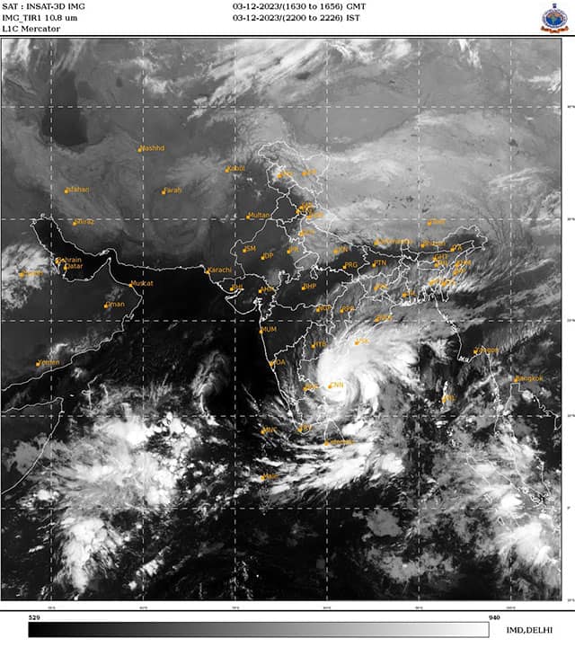 Cyclone Michaung parallel to Chennai coast viewed from satellite imagery[/caption] Dry East India brace up for wet weather this week It has been fairly dry in most parts of East India in the past few weeks. The cyclone Michaung is expected to recurve towards the northeast and weaken after making landfall. As a low-pressure area, it will travel up to Odisha. Under its influence, moderate to heavy rains are expected in many parts of Odisha and Chhattisgarh from 5 to 7 December. Meanwhile, light to moderate rains will affect Jharkhand and West Bengal on the 6 and 7 of December. The maximum temperature will take a significant drop as cloudy weather persists in the region. The upcoming unseasonal rains are expected to break the prolonged spell of dry weather in these states. Winters are showing slow progress in North India this year. The pattern of frequent cloudy weather and showers is disrupting the anti-cyclonic circulation build-up, which helps accommodate fog and trap cold air in the atmosphere. Hence, there is an irregular change in temperatures whenever there is an impact of a Western Disturbance or moisture coming up from the south. However, this week is expected to be mostly dry in North India, with negligible probability of a Western Disturbance until 10 December. The northwest winds will get a chance to settle. During the period from the 7 to 10 December, minimum temperatures are expected to fall by 1 to 2°C from current levels across Punjab, Haryana, Rajasthan, Uttar Pradesh, Delhi NCR, Gujarat, Madhya Pradesh and Maharashtra. Nights are expected to get colder due to clear skies and northern winds, but daytime temperatures won’t register any significant dip as fog is not holding up for a longer duration. The writer, better known as the Rohtak Weatherman, interprets and explains complex weather patterns. His impact-based forecasts @navdeepdahiya55 are very popular in north India. Views expressed in the above piece are personal and solely those of the author. They do not necessarily reflect Firstpost_’s views._ Read all the
Latest News ,
Trending News ,
Cricket News ,
Bollywood News , India News and
Entertainment News here. Follow us on
Facebook,
Twitter and
Instagram.
Cyclone Michaung parallel to Chennai coast viewed from satellite imagery[/caption] Dry East India brace up for wet weather this week It has been fairly dry in most parts of East India in the past few weeks. The cyclone Michaung is expected to recurve towards the northeast and weaken after making landfall. As a low-pressure area, it will travel up to Odisha. Under its influence, moderate to heavy rains are expected in many parts of Odisha and Chhattisgarh from 5 to 7 December. Meanwhile, light to moderate rains will affect Jharkhand and West Bengal on the 6 and 7 of December. The maximum temperature will take a significant drop as cloudy weather persists in the region. The upcoming unseasonal rains are expected to break the prolonged spell of dry weather in these states. Winters are showing slow progress in North India this year. The pattern of frequent cloudy weather and showers is disrupting the anti-cyclonic circulation build-up, which helps accommodate fog and trap cold air in the atmosphere. Hence, there is an irregular change in temperatures whenever there is an impact of a Western Disturbance or moisture coming up from the south. However, this week is expected to be mostly dry in North India, with negligible probability of a Western Disturbance until 10 December. The northwest winds will get a chance to settle. During the period from the 7 to 10 December, minimum temperatures are expected to fall by 1 to 2°C from current levels across Punjab, Haryana, Rajasthan, Uttar Pradesh, Delhi NCR, Gujarat, Madhya Pradesh and Maharashtra. Nights are expected to get colder due to clear skies and northern winds, but daytime temperatures won’t register any significant dip as fog is not holding up for a longer duration. The writer, better known as the Rohtak Weatherman, interprets and explains complex weather patterns. His impact-based forecasts @navdeepdahiya55 are very popular in north India. Views expressed in the above piece are personal and solely those of the author. They do not necessarily reflect Firstpost_’s views._ Read all the
Latest News ,
Trending News ,
Cricket News ,
Bollywood News , India News and
Entertainment News here. Follow us on
Facebook,
Twitter and
Instagram.
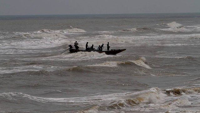
Southern parts of India is likely to face the brunt of Cyclone Michaung as extreme rains lash North Tamil Nadu, Chennai and Andhra Pradesh on Monday and Tuesday
Advertisement
End of Article

 "Russian drones over Poland: Trump’s tepid reaction a wake-up call for Nato?")
 "As Russia pushes east, Ukraine faces mounting pressure to defend its heartland")
 "Why Mossad was not on board with Israel’s strike on Hamas in Qatar")
 "Turkey: Erdogan's police arrest opposition mayor Hasan Mutlu, dozens officials in corruption probe")


