
 "Weather report: Coldwave, fog engulf north India on New Year, but little rain is expected")
Winter finally knocked on the doors of north India in the past week as fog engulfed for the first time in this season. Dense to very dense fog has engulfed entire Punjab, Haryana, Delhi NCR, Uttar Pradesh, and Bihar in the last couple of days. Also, it was on Saturday when the coverage of the fog was the largest in the season so far as it covered northwest Rajasthan, north Madhya Pradesh, north Jharkhand, and sub-Himalayan West Bengal. [caption id=“attachment_13563992” align=“alignnone” width=“300”] Satellite imagery shows fog covered entire north and some parts of east India on 31st December, 2023[/caption] The layer of fog is so thick that it penetrates even in the day, restricting temperatures to rise hence resulting in ‘cold day’ conditions in Punjab, Haryana, Delhi NCR, Uttar Pradesh and parts of north Rajasthan. A ‘cold day’ is declared when the actual maximum temperature of two or more stations within the state is recorded under 16°c. Top 10 lowest maximum temperature on Thursday in stations of northwest India; Gurdaspur: 11.5°C Ajnala: 11.5°C Nurmahal: 11.7°C Ludhiana: 11.8°C Karnal NDRI: 12.1°C Bahrowal: 12.1°C Barnala: 12.3°C Amritsar: 12.5°C Mungeshpur,Delhi: 12.5°C Sonipat: 12.5°C Yamunanagar: 12.6°C [caption id=“attachment_13564002” align=“alignnone” width=“300”]
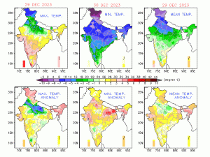 Below normal day temperatures across north India leading to cold day to severe cold day conditions[/caption] The plains have definitely got the taste of peak winters as the fog set in however warm winters still continue at the Himalayas under the absence of western disturbance it has turned out to be one of the warmest and driest December at various stations. Bhuntar in Kullu district of Himachal Pradesh recorded 2.6 mm rainfall during December 2023, this is lowest rainfall in the month of December after 2016. Bhuntar holds an average of 31.3 mm in December based on past 30 years of climatological data. Except north India winter conditions have remained buckled up till only certain parts of Madhya Pradesh and Chhattisgarh, temperatures have not dipped much in Gujarat, Maharashtra, Odisha, Telangana, Andhra Pradesh and Karnataka, cold weather continues to play hide and seek even at the last week of December. Northeast monsoon continues to stay away from Tamil Nadu and Kerala for another week as dry weather conditions were observed the states throughout last week of December, normally average rainfall decreases during this period but this time it’s only the winds which are easterlies are keeping the monsoon’s alive else it is the time of the year when monsoon exits from these states and dry weather prevail. The pan India actual rainfall so far in the period of 1st October till 24th December stands at 110.7 mm against the normal of 120.5 mm, the departure from normal currently stands at -8%, the rainfall deficiency has increased by 2% week over week. Subdivision wise seasonal rains till 30th December, 2023: • Southern Peninsula: Actual 238.3 mm against the average of 273.4 mm, -13% departure from normal. • East and northeast India: Actual 175.3 mm against the average of 158.8 mm, +10% departure from normal. • Northwest India: Actual 52.0 mm against the average of 51.8 mm, 0% departure from normal. • Central India: Actual 59.3 mm against the average of 75.9 mm, -22% departure from normal. [caption id=“attachment_13564012” align=“alignnone” width=“184”]
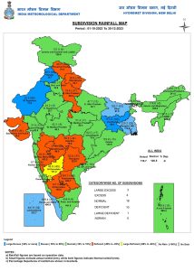 Sub division wise seasonal rainfall in India till 30th December, 2023[/caption] Current synoptic weather features influencing weather in India as on 31st December, 2023 • The western disturbance as a cyclonic circulation over north Pakistan at 3.1 km above mean sea level persists. However, the trough aloft in mid tropospheric levels at 5.8 km above mean sea level now runs roughly along Long. 68°E to the north of Lat. 32°N. • The induced cyclonic circulation over west Rajasthan & neighbourhood extending up to 1.5 km above mean sea level persists. • Another western disturbance seen as a trough in middle tropospheric westerlies at 5.8 km above mean sea level runs roughly along Long. 50°E to the north of Lat. 30°N. • The low pressure area over west equatorial Indian Ocean and adjoining southeast Arabian Sea and the associated upper-air cyclonic circulation extending up to mid-tropospheric levels persists. It is likely to move west-northwestwards and become a well marked low pressure area over central parts of south Arabian Sea and adjoining west equatorial Indian Ocean during next 48 hours. • The cyclonic circulation over northeast Bay of Bengal and adjoining Bangladesh at 1.5 km above mean sea level persists. All India weather forecast till 6th January, 2024: This new year, the weather conditions are expected to be dry across the country, as precipitation forecasts are negligible. It is only going to be mildly cold in the central and eastern parts of the country, as minimum temperatures are ranging 2–5 °C above normal. The winter chill will be missing in Maharashtra, Gujarat, Karnataka, Telangana, and Andhra Pradesh. As the night temperatures are expected to be in the single digits over Madhya Pradesh, Chhattisgarh, Odisha, West Bengal, and parts of north-east India, these regions can expect slightly cooler new year eve. The current situation of fog over north India is such that the layer looks irreplaceable for the next couple of days; however, on 31st December , the ground visibility improved slightly under the presence of surface winds that lifted the fog towards the sky, leading to the formation of upper-level fog. It generally looks like overcast conditions. Most parts of Punjab, Haryana, Delhi NCR, Rajasthan, Uttar Pradesh, Bihar, Jharkhand, and north-west Bengal experience both mixed surface and upper-level fog. In the case of surface fog, the visibility can go as low as 0 metres, while if it is upper-level fog, it might report around 200 metres. Irrespective of the type of fog, cold day conditions will be observed in a widespread area, as a lack of sunshine will result in daytime temperatures staying under 16°C. Certain stations in Punjab, Haryana, and western Uttar Pradesh can even record severe cold day conditions, as the maximum temperature might be reported around 10–12 °C, likely to be below normal by 7-9°C. First week of the new year hints for a coldwave Winter has shaped well in the past couple of days, and it is only going to get colder from here. A weak western disturbance has passed over the Himalayas, and now cool north-west winds will resume once again, coupled with fog layers. On the plains, both minimum and maximum temperatures will fall further by 2-4°C, especially between 2 January and 5 January, 2024, across Punjab, Haryana, Delhi NCR, Rajasthan, Uttar Pradesh, Bihar, Jharkhand, and West Bengal. Eventually, some bits of cold will be pushing into Gujarat, Maharashtra, Madhya Pradesh, Chhattisgarh, Odisha, Telangana, Andhra Pradesh, and Karnataka as dry and cold winds push in, leading to a drop in minimum temperature of 2–3 °C across the region from Wednesday onwards. Since the weather patterns in the country’s inland continue to stay weak, it will be hard to find any significant precipitation event in the nation for the first week of January. Only a weak wind discontinuity pattern might build up in central east India this midweek, resulting in localised light rains over east Madhya Pradesh, Chhattisgarh, east Uttar Pradesh, Jharkhand, and Bihar on 3rd and 4th January. In a longer-range model, an impactful western disturbance is not anticipated and is not expected until the 6th of January, but there is a glimpse of rain in the second and third weeks of January, and the long streak of dry weather in the country would break. The writer, better known as the Rohtak Weatherman, interprets and explains complex weather patterns. His impact-based forecasts @navdeepdahiya55 are very popular in north India. Views expressed in the above piece are personal and solely those of the author. They do not necessarily reflect Firstpost_’s views._ Read all the
Latest News ,
Trending News ,
Cricket News ,
Bollywood News , India News and
Entertainment News here. Follow us on
Facebook,
Twitter and
Instagram.
Sub division wise seasonal rainfall in India till 30th December, 2023[/caption] Current synoptic weather features influencing weather in India as on 31st December, 2023 • The western disturbance as a cyclonic circulation over north Pakistan at 3.1 km above mean sea level persists. However, the trough aloft in mid tropospheric levels at 5.8 km above mean sea level now runs roughly along Long. 68°E to the north of Lat. 32°N. • The induced cyclonic circulation over west Rajasthan & neighbourhood extending up to 1.5 km above mean sea level persists. • Another western disturbance seen as a trough in middle tropospheric westerlies at 5.8 km above mean sea level runs roughly along Long. 50°E to the north of Lat. 30°N. • The low pressure area over west equatorial Indian Ocean and adjoining southeast Arabian Sea and the associated upper-air cyclonic circulation extending up to mid-tropospheric levels persists. It is likely to move west-northwestwards and become a well marked low pressure area over central parts of south Arabian Sea and adjoining west equatorial Indian Ocean during next 48 hours. • The cyclonic circulation over northeast Bay of Bengal and adjoining Bangladesh at 1.5 km above mean sea level persists. All India weather forecast till 6th January, 2024: This new year, the weather conditions are expected to be dry across the country, as precipitation forecasts are negligible. It is only going to be mildly cold in the central and eastern parts of the country, as minimum temperatures are ranging 2–5 °C above normal. The winter chill will be missing in Maharashtra, Gujarat, Karnataka, Telangana, and Andhra Pradesh. As the night temperatures are expected to be in the single digits over Madhya Pradesh, Chhattisgarh, Odisha, West Bengal, and parts of north-east India, these regions can expect slightly cooler new year eve. The current situation of fog over north India is such that the layer looks irreplaceable for the next couple of days; however, on 31st December , the ground visibility improved slightly under the presence of surface winds that lifted the fog towards the sky, leading to the formation of upper-level fog. It generally looks like overcast conditions. Most parts of Punjab, Haryana, Delhi NCR, Rajasthan, Uttar Pradesh, Bihar, Jharkhand, and north-west Bengal experience both mixed surface and upper-level fog. In the case of surface fog, the visibility can go as low as 0 metres, while if it is upper-level fog, it might report around 200 metres. Irrespective of the type of fog, cold day conditions will be observed in a widespread area, as a lack of sunshine will result in daytime temperatures staying under 16°C. Certain stations in Punjab, Haryana, and western Uttar Pradesh can even record severe cold day conditions, as the maximum temperature might be reported around 10–12 °C, likely to be below normal by 7-9°C. First week of the new year hints for a coldwave Winter has shaped well in the past couple of days, and it is only going to get colder from here. A weak western disturbance has passed over the Himalayas, and now cool north-west winds will resume once again, coupled with fog layers. On the plains, both minimum and maximum temperatures will fall further by 2-4°C, especially between 2 January and 5 January, 2024, across Punjab, Haryana, Delhi NCR, Rajasthan, Uttar Pradesh, Bihar, Jharkhand, and West Bengal. Eventually, some bits of cold will be pushing into Gujarat, Maharashtra, Madhya Pradesh, Chhattisgarh, Odisha, Telangana, Andhra Pradesh, and Karnataka as dry and cold winds push in, leading to a drop in minimum temperature of 2–3 °C across the region from Wednesday onwards. Since the weather patterns in the country’s inland continue to stay weak, it will be hard to find any significant precipitation event in the nation for the first week of January. Only a weak wind discontinuity pattern might build up in central east India this midweek, resulting in localised light rains over east Madhya Pradesh, Chhattisgarh, east Uttar Pradesh, Jharkhand, and Bihar on 3rd and 4th January. In a longer-range model, an impactful western disturbance is not anticipated and is not expected until the 6th of January, but there is a glimpse of rain in the second and third weeks of January, and the long streak of dry weather in the country would break. The writer, better known as the Rohtak Weatherman, interprets and explains complex weather patterns. His impact-based forecasts @navdeepdahiya55 are very popular in north India. Views expressed in the above piece are personal and solely those of the author. They do not necessarily reflect Firstpost_’s views._ Read all the
Latest News ,
Trending News ,
Cricket News ,
Bollywood News , India News and
Entertainment News here. Follow us on
Facebook,
Twitter and
Instagram.
Only a weak wind discontinuity pattern might build up in central east India this midweek, resulting in localised light rains over east Madhya Pradesh, Chhattisgarh, east Uttar Pradesh, Jharkhand, and Bihar on 3rd and 4th January
Advertisement
End of Article

 "Russian drones over Poland: Trump’s tepid reaction a wake-up call for Nato?")
 "As Russia pushes east, Ukraine faces mounting pressure to defend its heartland")
 "Why Mossad was not on board with Israel’s strike on Hamas in Qatar")
 "Turkey: Erdogan's police arrest opposition mayor Hasan Mutlu, dozens officials in corruption probe")


