
 "Weather report | Cold waves to abate in North, South will continue to have dry days")
The severe winters of this season finally came to an end last week as the passage of western disturbances led to an increase in wind speed across the plains of north India, resulting in the dissipation of fog. The maximum temperature has started to cross the 20°C mark at a lot of stations, and days are getting pleasant with clear blue skies; however, coldwave conditions are experienced during the night as clear skies ensure a free fall in night temperature. Minimum Temperature recorded in plains on February 10, 2024: Mahendragarh: 2.0°C Gurgaon: 2.8°C Rewari: 2.9°C Fatehpur, Sikar: 3.5°C Hisar: 3.6°C Karauli: 3.6°C Ujwa, Delhi: 3.9°C Ayodhya: 4.0°C Adampur: 4.0°C Jhajjar: 4.2°C Pilani: 4.5°C Kanpur: 4.8°C Sonipat: 4.8°C Karnal: 5.0°C Dry weather conditions have prevailed over the entire country in the past week, except for some minimal rainfall that has occurred in parts of east Madhya Pradesh, Chhattisgarh, and Jharkhand on February 9 and 10. The southern peninsula experienced dry and warm weather conditions as temperatures started crossing the 35°C mark in Kerala, Karnataka, and Tamil Nadu. [caption id=“attachment_13717522” align=“alignnone” width=“300”] Similar to January, it has been warmer than normal in south and central India while north India has experienced cooler temperatures in the month of February[/caption] The actual rainfall in pan India so far in the period from January 1 to February 11 stands at 15.1 mm against the normal of 24.6 mm; the departure from normal currently stands at -39 per cent, having increased by 1 per cent week over week. Subdivision-wise winter seasonal rainfall till February 11, 2024: • Southern peninsula: Actual 18.5 mm against the average of 10.5 mm, +76 per cent departure from normal. • East and northeast India: Actual 16.6 mm against the average of 26.6 mm, -39 per cent departure from normal. • Northwest India: Actual 22.2 mm against the average of 48.4 mm, -54 per cent departure from normal. • Central India: Actual 6.0 mm against the average of 10.2 mm, -42 per cent departure from normal. [caption id=“attachment_13717542” align=“alignnone” width=“214”]
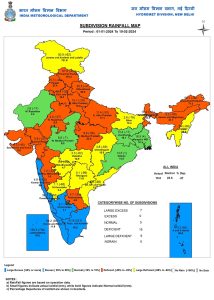 Subdivision-wise seasonal rainfall in India from February 1 to 10, 2024[/caption] Current synoptic weather features influencing weather in India as on February 12, 2024:
- A fresh western disturbance as a trough in mid-tropospheric westerlies with its axis at 5.8 km above mean sea level runs roughly along Long. 55°E to the north of Lat. 25°N.
- The cyclonic circulation over the south Gujarat region and neighbourhood at 1.5 km above mean sea level persists.
- The trough from South Interior Karnataka to west Vidarbha across North Interior Karnataka and Marathwada at 0.9 km above mean sea level persists.
- The cyclonic circulation over south Assam at 3.1 km above mean sea level persists.
All India weather forecast till February 18, 2024: The wind pattern over the eastern parts of India has been a bit unstable since the weekend, and scattered thunder clouds have been triggered in the region. The same instability will continue at the beginning of the week as well. This will result in light to moderate rains and thundershowers across east Madhya Pradesh, Chhattisgarh, Jharkhand, Bihar, and Uttar Pradesh during February 12–14. Remaining regions like north, west, and south India would continue to observe dry weather until February 18, with a rise in both minimum and maximum temperature by 2 to 3°C from current levels, resulting in the onset of spring in north and central India. Coldwave conditions will abate in most parts of the plains, and morning hours will only feel slightly cold as the minimum temperature will not start crossing the 10°C mark and will be recorded around normal ranges. [caption id=“attachment_13717562” align=“alignnone” width=“270”] Satellite imagery indicating a fresh, weak western disturbance over north India on February 12; cloudy weather in some parts of east India due to wind instability[/caption] In El Nino years, western disturbances are very common during spring and early summer, which cause hailstorms and bring in plenty of damage to standing rabi crops. Similarly, this season, above-normal precipitation is predicted in the second half of February into March, and a new series of active western disturbances will start affecting the Himalayas and plains of north India from February 19 onwards. A fresh spell of wet and cool weather will begin once again. The writer, better known as the Rohtak Weatherman, interprets and explains complex weather patterns. His impact-based forecasts @navdeepdahiya55 are very popular in north India. Views expressed in the above piece are personal and solely those of the author. They do not necessarily reflect Firstpost_’s views._ Read all the
Latest News ,
Trending News ,
Cricket News ,
Bollywood News , India News and
Entertainment News here. Follow us on
Facebook,
Twitter and
Instagram.

 "Russian drones over Poland: Trump’s tepid reaction a wake-up call for Nato?")
 "As Russia pushes east, Ukraine faces mounting pressure to defend its heartland")
 "Why Mossad was not on board with Israel’s strike on Hamas in Qatar")
 "Turkey: Erdogan's police arrest opposition mayor Hasan Mutlu, dozens officials in corruption probe")


