Monsoon rains tried to establish over India in the past week with a slow-moving low pressure area over Uttar Pradesh but failed to hold up as dry air incursions from the west led to weakening of the weather system, and once again the eastern and western arms of the monsoon axis decided to move towards the Himalayan foothills, leaving India’s heartland dry. The monsoon axis has remained at the foothills for more than 20 days this month; this means more rains over the hilly regions and less in plains. Rainfall in major stations of Himachal Pradesh in month of August: Palampur: 889.0 mm Dharamshala: 845.7 mm Mandi: 742.5 mm Sundernagar: 677.5 mm Bilaspur: 621.8 mm Shimla: 577.1 mm Nahan: 331.2 mm Solan: 283.4 mm Bhuntar: 139.6 mm Manalia: 73.0 mm Kalpa: 15.9 mm Kukumsheri: 5.5 mm Rishikesh in Uttarakhand recorded a total rainfall of 1854.6 mm so far which is highest in the country in the ongoing month. Mawsynram, Meghalaya one of the wettest places in the world eager to overtake, currently August total here stands at 1805.9 mm. A town in the Himalayas of northwest India leading resembles the presence of the monsoon axis over foothills of Himalayas for longer than usual. Monsoon 2023-led losses over the hilly state are at an all time high. At least, 367 deaths have been reported in Himachal Pradesh since 24 June and 40 people are still missing. Projected 8000 crore loss has happened to State and above 12000 houses partially or fully have been damaged. Sundernagar city has received record shattering 697.2 mm rainfall in August so far this is the highest monthly rainfall since the observatory became operational in 1981. On Saturday night western disturbance led rain spell brought drop in Shimla’s temperature to 13.6°C. This became the lowest minimum temperature recorded in Shimla city station after 2010 during the month of August meanwhile the all time low for the month is 10.9°C from 14th August 2010. [caption id=“attachment_13046752” align=“alignnone” width=“625”]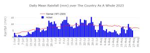 Daily mean rainfall on a pan India level since 1 June till 26 August, 2023.[/caption] Monsoon turns slightly active over the Mumbai and Konkan region during this weekend, as rainfall ending 8:30 am on 26 August suggests. Rainfall/Observatory: Sawantwadi: 87 mm Kudal: 80 mm Ambernath: 65 mm Vaibhavwadi: 64 mm Kalyan: 63 mm Vashi: 62 mm Malvan: 57 mm Dombivli: 52 mm Chiplun: 51 mm Badlapur: 50 mm Harne: 48 mm Mumbai: 45 mm Ulhasnagar: 42 mm Dapoli: 41 mm Thane: 39 mm Vasai: 32 mm Rajapur: 30 mm Although large parts of Punjab, Haryana, Delhi NCR, Uttar Pradesh, Rajasthan, Madhya Pradesh, Gujarat, Chhattisgarh, Odisha, Telangana, Karnataka, Maharashtra, Kerala experienced dry weather conditions over the weekend. When core monsoon zones hit a break, the north east rejoiced with good rains, in the past 24 hours ending 8:30 am on 27 August Cherrapunji recorded 166 mm, also Shillong experienced heavy downpour of 96 mm. Mawsynram recorded 378.4 mm Rainfall during the last 24 hours till 8:30 am on 27 August, the monthly total now stands at 2301.3 mm. Seasonal since 1st June has crossed the 8000 mm mark. Rainfall in some other stations of Meghalaya ending 8:30 am on Sunday morning; Cherrapunji RKM: 290.6 mm Shella: 247.2 mm Mawphlang: 184.6 mm Mawkyrwat: 175.0 mm Pynursla: 168.0 mm Cherrapunji Main: 166.0 mm As on 26 August, the seasonal rainfall over pan India stands at an actual of 616.6 mm against the normal of 664.7 mm the departure from normal stands at -7 per cent compared to week on week of -6 per cent, fell by another 1 per cent. Subdivision wise seasonal rainfall in the period of 1 June till 26 August, 2023: • Southern Peninsula: Actual 444.9 mm against the average of 529.4 mm, -16 per cent departure from normal. • East and North East India: Actual 859.8 mm against the average of 1037.1 mm, -17 per cent departure from normal. • North West India: Actual 496.8 mm against the average of 460.7 mm, +8 per cent departure from normal. • Central India: Actual 711.1 mm against the average of 753.6 mm, -6 per cent departure from normal. [caption id=“attachment_13046762” align=“alignnone” width=“606”]
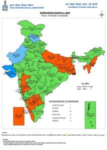 Subdivision wise seasonal rainfall in India till 26 August, 2023[/caption] Current synoptic weather features influencing weather in India as on 27 August: • The western end of Monsoon Trough at mean sea level continues to run along the foothills of the Himalayas and its eastern end now passes through Gorakhpur, Patna, Malda and thence eastwards to Manipur across south Assam. • The cyclonic circulation over northeast Bangladesh and neighbourhood extending up to 3.1 km above mean sea level with trough aloft runs from sub-Himalayan West Bengal to northeast Bay of Bengal between 4.5 and 5.8 km above mean sea level persists. • The Western Disturbance exists as a trough in middle tropospheric westerlies with its axis at 5.8 km above mean sea level roughly along Long. 70°E to the north of Lat. 30°N persists. [caption id=“attachment_13046792” align=“alignnone” width=“611”]
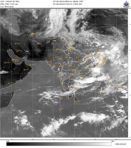 Satellite imagery on Sunday afternoon represents clear skies in 70 per cent part of the country[/caption] All India weather forecast till 3 September 2023: Monsoon struggles to revive, break conditions to extend next week: As the monsoon axis shifted to the foothills of Himalayas along with no projection for low pressure area in Bay of Bengal for another one week the break in monsoon conditions will extend for another 6 to 7 days and August is expected to end on a major dry note across India, September start likely to be no different as dry weather conditions will continue to grip at least till next weekend. Large deficit rains are predicted for Punjab, Haryana, Delhi NCR, Uttar Pradesh, Rajasthan, Gujarat, Madhya Pradesh, Maharashtra, Karnataka in the upcoming week, with temperature soaring as high as 38°C during the day time, expected to be above normal by 4 to 5°C in this week. The westerly winds will keep the moisture content away but some convergence around east India will lead to scattered light to moderate rains or thunderstorms in the evening hours over Odisha, Chhattisgarh, Andhra Pradesh and Telangana, despite some rains this part of the country will experience below average rains for the week. It’s the north east benefit, the eastern arm of monsoon axis is situated well over Arunachal Pradesh for the entire next week, this will result in moderate to heavy rains in Sikkim, Meghalaya, Mizoram, Manipur, Nagaland, Tripura, Assam and Arunachal Pradesh, some parts might even experiencing very heavy rains during Monday till Wednesday. A scope of monsoon recovery in September While August may end on record dry note, September is showing hope for some revival of monsoons in India. The low pressure area which is the powerhouse of monsoon is expected to develop in Bay of Bengal around 3 September and travel inland in the first week of the month, further there will be another system following the track in second week, the much needs moisture and rains will travel inland as per mid range weather models, after a poor August these low pressure areas in September will be the last hope for the farmers who’s kharif crop is on the verge of drought hit. The writer, better known as the Rohtak Weatherman, interprets and explains complex weather patterns. His impact-based forecasts @navdeepdahiya55 are very popular in north India. Views expressed in the above piece are personal and solely that of the author. They do not necessarily reflect Firstpost_’s views._ Read all the
Latest News
,
Trending News
,
Cricket News
,
Bollywood News
, India News
and
Entertainment News
here. Follow us on
Facebook
,
Twitter
and
Instagram
.
Satellite imagery on Sunday afternoon represents clear skies in 70 per cent part of the country[/caption] All India weather forecast till 3 September 2023: Monsoon struggles to revive, break conditions to extend next week: As the monsoon axis shifted to the foothills of Himalayas along with no projection for low pressure area in Bay of Bengal for another one week the break in monsoon conditions will extend for another 6 to 7 days and August is expected to end on a major dry note across India, September start likely to be no different as dry weather conditions will continue to grip at least till next weekend. Large deficit rains are predicted for Punjab, Haryana, Delhi NCR, Uttar Pradesh, Rajasthan, Gujarat, Madhya Pradesh, Maharashtra, Karnataka in the upcoming week, with temperature soaring as high as 38°C during the day time, expected to be above normal by 4 to 5°C in this week. The westerly winds will keep the moisture content away but some convergence around east India will lead to scattered light to moderate rains or thunderstorms in the evening hours over Odisha, Chhattisgarh, Andhra Pradesh and Telangana, despite some rains this part of the country will experience below average rains for the week. It’s the north east benefit, the eastern arm of monsoon axis is situated well over Arunachal Pradesh for the entire next week, this will result in moderate to heavy rains in Sikkim, Meghalaya, Mizoram, Manipur, Nagaland, Tripura, Assam and Arunachal Pradesh, some parts might even experiencing very heavy rains during Monday till Wednesday. A scope of monsoon recovery in September While August may end on record dry note, September is showing hope for some revival of monsoons in India. The low pressure area which is the powerhouse of monsoon is expected to develop in Bay of Bengal around 3 September and travel inland in the first week of the month, further there will be another system following the track in second week, the much needs moisture and rains will travel inland as per mid range weather models, after a poor August these low pressure areas in September will be the last hope for the farmers who’s kharif crop is on the verge of drought hit. The writer, better known as the Rohtak Weatherman, interprets and explains complex weather patterns. His impact-based forecasts @navdeepdahiya55 are very popular in north India. Views expressed in the above piece are personal and solely that of the author. They do not necessarily reflect Firstpost_’s views._ Read all the
Latest News
,
Trending News
,
Cricket News
,
Bollywood News
, India News
and
Entertainment News
here. Follow us on
Facebook
,
Twitter
and
Instagram
.
Weather Report: August to end on record dry note, but September hopes revival of monsoon
Navdeep Dahiya
• August 28, 2023, 12:06:09 IST
A low-pressure area is expected to develop in the Bay of Bengal around 3 September and travel inland in the first week of the coming month
Advertisement
 "Weather Report: August to end on record dry note, but September hopes revival of monsoon")
End of Article