
 "Weather report: As Himalayas experience record-breaking temperatures, the northern plains shiver in cold")
The Himalayas are experiencing one of the driest winters ever, as no significant precipitation has occurred over the hilly states since October 31, 2023, until January 14, 2024. The situation is alarming as most peaks are snow-free even in the peak winters. Chillai Kalan, the famous harsh winter of Kashmir, has been missing so far. Instead, the region, along with other states like Himachal Pradesh and Uttarakhand, has been experiencing record-breaking high temperatures in the past week. On January 13, Srinagar recorded a minimum temperature of 15.0 °C, and it turned out to be the warmest January day in 14 years. The maximum temperature was staggering 8.6°C above average for the day. In the last decade, on January 25, 2010, Srinagar recorded a maximum temperature of 15.8°C. The monthly all-time highest temperature ever recorded in the city was 17.2°C on January 23, 1902. Some more new heat records in January from the Kashmir region and other states of the Himalayas in the past week: • Qazigund reported 15.8°C on January 13, failing to break the decadal record of 16.0°C from January 29, 2010. It is the third highest temperature since 1956. The all-time high is 16.2°C from January 31, 2001. • Pahalgam experienced a maximum temperature of 13.1°C, becoming the third highest monthly temperature recorded in Pahalgam since 1978. The all-time record of 13.8°C from January 14, 2018 stood unbroken. • Kupwara saw a maximum temperature of 15.8°C and matched with the decadal high of 15.8°C from January 18, 2010. It is also the fourth highest temperature since 1977. All time record of 16.9°C from January 8, 2015, stood unbroken. • Kalpa in Kinnaur district of Himachal Pradesh recorded 3.8°C minimum temperature on January 13. It was exceptionally above normal by 8°C and set a new record of highest ever recorded minimum temperature for the month of January by breaking the previous record of 3.6°C from January 12, 2018. On the same day Kalpa reported 15.0°C maximum temperature and was 10°C above normal, adjusted as the highest temperature reported in the month of January in the last 20 years, the all-time high of 16.1°C from January 19, 2003. On the other hand, Solan reported 26.5°C and became the highest reported temperature in the month of January after 2007. • State capital Shimla recorded 19.4°C maximum temperature on January 13, which was 8°C above normal. Here are the top 3 historical high temperatures in Shimla during the month of January. Interestingly, all the records of high temperatures are from the current century:
- 20.6°C on January 16, 2018
- 20.7°C on January 21, 2009
- 21.4°C on January 30, 2006
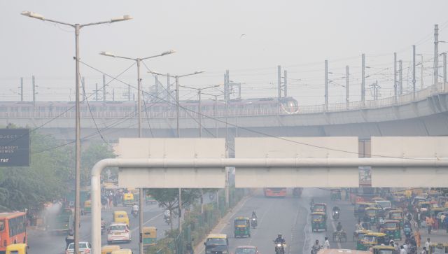
[caption id=“attachment_13615122” align=“alignnone” width=“300”] Record breaking above normal temperature recorded over Himalayas on the weekend[/caption] The absence of western disturbance and cloudy weather is keeping the historical run of dry winter alive in the Himalayan ranges. With every passing day and rising temperature, the trouble is increasing for the farmers and locals, and tourism is at a low this time in the absence of snowfall. While hills suffer the historical warm winters, their nearest neighbour in plains Punjab is experiencing extreme winters this time. Most parts have not seen maximum temperature going above 14°C since December-end with intermittent single-digit max, and now minimums have started falling below freezing point. On January 15, Ballowal Saunkhri (SBS Nagar) recorded a minimum of -0.2 °C, the first subzero of the season in the state. The nearest large city, Ludhiana, reported a minimum temperature of 1.0°C (5°C below normal). Following the very cold and foggy weekend that impacted rail, roads, and airways in the plains, Monday starts on a cooler note as the minimum temperature falls to the season’s lowest at many stations. The coldest morning of the season is witnessed in the Delhi NCR region under the influence of a cold wave as minimum temperatures plummet to 2.0°C, 3.1°C, and 3.3°C, respectively, at Gurgaon, Lodi Road, and Safdarjung observatory, with surface visibility in the range of 0-100 metres at 8:30 am. Dense fog (surface + upper levels) is realised via satellite imagery across IGP yet again. Minimum temperature in some other cities on January 15, with cold wave conditions (below 4°C minimum): Mahendargarh: 0.4°C Fatehpur S: 0.9°C Rewari: 1.6°C Narnaul: 1.8°C Hisar: 2.4°C Churu: 2.9°C Sikar: 3.0°C Karnal: 3.1°C Patiala: 3.2°C Ambala: 3.6°C Chandigarh: 3.6°C Meerut: 3.6°C [caption id=“attachment_13615132” align=“alignnone” width=“277”]
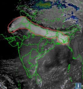 Dense fog realised via satellite imagery on Sunday morning across plains of north India[/caption] While the northern plains are under the grip of fog and bone-chilling cold, it is the high pressure area over central India that keeps winters away from Maharashtra, Madhya Pradesh, Gujarat, and neighbouring areas where summer-like maximum temperatures are reported. Maximum temperature in Mumbai metro region reported on January 12: Chiplun: 38°C Savarde: 37.4°C Karjat and Dapoli: 37.2°C Kalyan: 37°C Thane and Badlapur: 36.6°C Panvel and Talasari: 36.3°C Navi Mumbai and Mira Rd: 36°C Mumbai: 35.7°C Virar: 35.6°C Ratnagiri: 35.4°C East has seen some cool down on the weekend as well as on Monday as temperatures have started reducing under the influence of cold north-west winds. Jharkhand’s state capital, Ranchi, reported a minimum temperature of 6.4°C on Monday morning, which was the season’s lowest. Also, temperatures fell in various parts of west Bengal, Odisha, and Chhattisgarh. The actual rainfall in India so far in the period from January 1 to 14 stands at 4.4mm against the normal of 6.7mm; the departure from normal currently stands at -34 per cent. This has increased by 2 weeks over the past week as mostly dry weather conditions have prevailed in the country. Subdivision wise winter seasonal rainfall till January 14, 2024: • Southern Peninsula: Actual 16.5 mm against the average of 4.6 mm, +259 per cent departure from normal. • East and North East India: Actual 0.6 mm against the average of 6.3 mm, -90 per cent departure from normal. • Northwest India: Actual 0.7 mm against the average of 11.9 mm, -94 per cent departure from normal. • Central India: Actual 2.5 mm against the average of 3.5 mm, -28 per cent departure from normal. [caption id=“attachment_13615152” align=“alignnone” width=“214”]
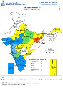 Subdivision-wise seasonal rainfall in India in the period of January 1 to January 14, 2024[/caption] Current synoptic features influencing weather in India as on January 15, 2024: • The cyclonic circulation over south Bangladesh and neighbourhoods extending up to 1.5 km above mean sea level persists. • A fresh feeble western disturbance is likely to affect western Himalayan region from January 16, 2024. All India weather forecast till January 21, 2024: The anti-cyclonic circulation, which is present as a high-pressure area over central India, will start disappearing in the upcoming week, while this might not bring any significant precipitation events to the country until January 21, except for some parts of Odisha and West Bengal, which will experience light to moderate rainfall during January 17–18 under the influence of the cyclonic circulation over Bangladesh. The remaining parts of east India, as well as the entire north, central, and south of India, will continue to witness dry weather conditions for another week. As the barrier moves away, it will push cold north-west winds deep into the interiors of India; hence, finally, nighttime temperatures are expected to fall by 2-3°C across Madhya Pradesh, Chhattisgarh, Gujarat, Maharashtra, Karnataka, Telangana, Andhra Pradesh, Goa, Kerala, and Tamil Nadu. The long-awaited winter chill will be felt in large parts of India. In the absence of western disturbance, the Himalayas and plains will continue to experience dry weather conditions, but Punjab, Haryana, Delhi NCR, Uttar Pradesh, Bihar, and Rajasthan will see dense fog conditions during late nights and morning hours. Cold wave conditions will continue across the country next week as minimum temperatures will continue to prevail in the range of 0 to 5°C in a lot of cities. Maximum temperatures are also likely to be in the range of 12 to 20°C. The minimum temperature would be below normal by 2 to 5°C, while the maximum temperature is likely below normal by 4 to 8°C; hence, no respite is expected from biting cold in the plains of north India, while the Himalayas will continue to deal with unprecedented high temperatures. The writer, better known as the Rohtak Weatherman, interprets and explains complex weather patterns. His impact-based forecasts @navdeepdahiya55 are very popular in north India. Views expressed in the above piece are personal and solely those of the author. They do not necessarily reflect Firstpost_’s views._ Read all the
Latest News ,
Trending News ,
Cricket News ,
Bollywood News , India News and
Entertainment News here. Follow us on
Facebook,
Twitter and
Instagram.
Subdivision-wise seasonal rainfall in India in the period of January 1 to January 14, 2024[/caption] Current synoptic features influencing weather in India as on January 15, 2024: • The cyclonic circulation over south Bangladesh and neighbourhoods extending up to 1.5 km above mean sea level persists. • A fresh feeble western disturbance is likely to affect western Himalayan region from January 16, 2024. All India weather forecast till January 21, 2024: The anti-cyclonic circulation, which is present as a high-pressure area over central India, will start disappearing in the upcoming week, while this might not bring any significant precipitation events to the country until January 21, except for some parts of Odisha and West Bengal, which will experience light to moderate rainfall during January 17–18 under the influence of the cyclonic circulation over Bangladesh. The remaining parts of east India, as well as the entire north, central, and south of India, will continue to witness dry weather conditions for another week. As the barrier moves away, it will push cold north-west winds deep into the interiors of India; hence, finally, nighttime temperatures are expected to fall by 2-3°C across Madhya Pradesh, Chhattisgarh, Gujarat, Maharashtra, Karnataka, Telangana, Andhra Pradesh, Goa, Kerala, and Tamil Nadu. The long-awaited winter chill will be felt in large parts of India. In the absence of western disturbance, the Himalayas and plains will continue to experience dry weather conditions, but Punjab, Haryana, Delhi NCR, Uttar Pradesh, Bihar, and Rajasthan will see dense fog conditions during late nights and morning hours. Cold wave conditions will continue across the country next week as minimum temperatures will continue to prevail in the range of 0 to 5°C in a lot of cities. Maximum temperatures are also likely to be in the range of 12 to 20°C. The minimum temperature would be below normal by 2 to 5°C, while the maximum temperature is likely below normal by 4 to 8°C; hence, no respite is expected from biting cold in the plains of north India, while the Himalayas will continue to deal with unprecedented high temperatures. The writer, better known as the Rohtak Weatherman, interprets and explains complex weather patterns. His impact-based forecasts @navdeepdahiya55 are very popular in north India. Views expressed in the above piece are personal and solely those of the author. They do not necessarily reflect Firstpost_’s views._ Read all the
Latest News ,
Trending News ,
Cricket News ,
Bollywood News , India News and
Entertainment News here. Follow us on
Facebook,
Twitter and
Instagram.

 "Russian drones over Poland: Trump’s tepid reaction a wake-up call for Nato?")
 "As Russia pushes east, Ukraine faces mounting pressure to defend its heartland")
 "Why Mossad was not on board with Israel’s strike on Hamas in Qatar")
 "Turkey: Erdogan's police arrest opposition mayor Hasan Mutlu, dozens officials in corruption probe")


