Monsoon finally decided the drench the parched region of east and north east India with good rain in the past week, the first monsoonal depression formed up in the Bay of Bengal and travelled in states of Odisha, West Bengal, Jharkhand, Chhattisgarh, north east Madhya Pradesh and into parts of Uttar Pradesh along with that the monsoon axis was attached to it, support of moisture feeding winds from Bay of Bengal to the seven sister states helped in quick revival of monsoon and the first batch very heavy to extremely heavy rains were delivered to eastern half of the country. This year east and northeast India recorded third lowest July rainfall since 1901. July 2022: 234.8 mm July 1903: 249.5 mm July 2023: 280.9 mm Also recorded highest July average minimum temperature since 1901, on opposite northwest India saw highest July rains since 2001 [caption id=“attachment_12967532” align=“alignnone” width=“611”]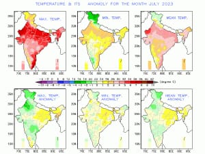 Below normal rains lead to highest ever temperature anomaly in north east India since 1901 in the month of July, 2023[/caption] As soon the region hit August number started turning around, August started on record breaking note for capital city of Odisha, Bhubaneswar received 259 mm rainfall ending 8:30 am on 1st August broke the all time record of highest single day rainfall for the month of August, city was flooded as most of the precipitation fell in the period of just 6 hours. Extreme rains in the span of 24 hours ending 8:30 am on 2 August in various stations of Odisha: Observatory/ Rainfall Boudh: 390.6 mm Sonepur: 213.6 mm Phulbani: 205.6 mm Bolangir: 173.0 mm Keonjhar: 150.2 mm Angul: 150.0 mm Talcher: 147.7 mm Bhawanipatna: 147.0 mm Balasore: 137.7 mm Very heavy to extremely heavy rains lashed parts of Madhya Pradesh and Chhattisgarh ending 8:30 am on 3 August. Rainfall during last 24 hours till 8:30 am: Observatory/ Rainfall Bichhia: 239 mm Gohparu: 227 mm Raipura: 203 mm Bihari: 168 mm Kumdam: 166 mm Anuppur: 163 mm Jabera: 159 mm Dharamjaigarh: 223 mm Surajpur: 158 mm Bilha: 118 mm Mahasamund: 112 mm Ambikapur: 106 mm Cherrapunji recorded 240 mm rainfall during the last 24 hours ending 8:30 am on 7 August followed by Agartala which saw 142 mm and recorded the highest single day rain in the month of August at least since 2011. As on 6 August, the seasonal rainfall over pan India stands at an actual of 514.4 mm against the normal of 500.2 mm the departure from normal stands at +3 per cent compared to week on week of +6 per cent, fell by 3 per cent. Subdivision wise seasonal rainfall in the period of 1 June till 6 August, 2023: • Southern Peninsula: Actual 393.7 mm against the average of 405.8 mm, -3 per cent departure from normal. • East and North East India: Actual 628.0 mm against the average of 815.5 mm, -23 per cent departure from normal. • North West India: Actual 403.7 mm against the average of 330.2 mm, +22 per cent departure from normal. • Central India: Actual 632.3 mm against the average of 561.3 mm, +13 per cent departure from normal. [caption id=“attachment_12967552” align=“alignnone” width=“805”]
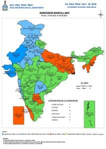 Sub division wise seasonal rainfall in India in the period of 1 June till 6 August, 2023[/caption] Current synoptic features influencing weather in India as on 7 August, 2023: • The cyclonic circulation over south Bihar and neighbourhood extending up to 1.5 km above mean sea level with a trough aloft roughly along Lat. 88°E to the north of 22°N at 3.1 km above mean sea level persists. • The western end of monsoon trough at mean sea level runs close to the foothills of the Himalayas and eastern end now passes through Gorakhpur, Vaishali, Malda and thence eastwards towards Manipur. All India weather forecast and monsoon status till 13 August 2023: The great start of the season have not always result in good end, after one of the finest July in many years in terms of precipitation over the country monsoon is heading for a longer lul period with lesser hope of quick recovery in the month of August, the signs are already there as the monsoon axis has shifted to the foothills of Himalayas, under the influence most of the moisture content will restrict it to the western Himalayas, foothills and over north east India and so it the rain, this is the typical feature of break in monsoon conditions, the dry westerly winds will dominate west, north west, Central and southern parts of the country with almost no or subdued rainfall over the entire week and two. States and UTs to be affected with heavy rains till 13 August: Bihar, Jharkhand, Sub Himalayan West Bengal, Sikkim, Assam, Arunachal Pradesh, Mizoram, Manipur, Nagaland, Tripura. States and UTs with subdued rainfall impact till 13 August: Jammu, Kashmir, Ladakh, Himachal Pradesh, Uttarakhand, Punjab, Chandigarh, Haryana, Delhi, Uttar Pradesh, Madhya Pradesh, Chhattisgarh, Odisha, Telangana, Kerala, Karnataka, Goa. States and UTs with nearly dry weather conditions till 13 August: Gujarat, Rajasthan, Tamil Nadu and Andhra Pradesh. El Nino leaving its imprint in August? Active and break phases are part of monsoons seasonal variability they are not exactly proportional to the impact of El Nino, over the years it has been analysed that August is becoming prone to longer breaks, also during El Nino conditions the break tends to extend for longer duration for example during La Nina or neutral ENSO conditions if monsoon break usually last for 10 days during El Nino it can get extended for 15 to a max of 20 days which is significantly high. If this holds true in 2023 August might end on a major deficit note as the start of the month during the first week has not been cheerful except northeast and east India. The writer, better known as the Rohtak Weatherman, interprets and explains complex weather patterns. His impact-based forecasts @navdeepdahiya55 are very popular in north India. Views expressed in the above piece are personal and solely that of the author. They do not necessarily reflect Firstpost_’s views._ Read all the
Latest News
,
Trending News
,
Cricket News
,
Bollywood News
, India News
and
Entertainment News
here. Follow us on
Facebook
,
Twitter
and
Instagram
.
Sub division wise seasonal rainfall in India in the period of 1 June till 6 August, 2023[/caption] Current synoptic features influencing weather in India as on 7 August, 2023: • The cyclonic circulation over south Bihar and neighbourhood extending up to 1.5 km above mean sea level with a trough aloft roughly along Lat. 88°E to the north of 22°N at 3.1 km above mean sea level persists. • The western end of monsoon trough at mean sea level runs close to the foothills of the Himalayas and eastern end now passes through Gorakhpur, Vaishali, Malda and thence eastwards towards Manipur. All India weather forecast and monsoon status till 13 August 2023: The great start of the season have not always result in good end, after one of the finest July in many years in terms of precipitation over the country monsoon is heading for a longer lul period with lesser hope of quick recovery in the month of August, the signs are already there as the monsoon axis has shifted to the foothills of Himalayas, under the influence most of the moisture content will restrict it to the western Himalayas, foothills and over north east India and so it the rain, this is the typical feature of break in monsoon conditions, the dry westerly winds will dominate west, north west, Central and southern parts of the country with almost no or subdued rainfall over the entire week and two. States and UTs to be affected with heavy rains till 13 August: Bihar, Jharkhand, Sub Himalayan West Bengal, Sikkim, Assam, Arunachal Pradesh, Mizoram, Manipur, Nagaland, Tripura. States and UTs with subdued rainfall impact till 13 August: Jammu, Kashmir, Ladakh, Himachal Pradesh, Uttarakhand, Punjab, Chandigarh, Haryana, Delhi, Uttar Pradesh, Madhya Pradesh, Chhattisgarh, Odisha, Telangana, Kerala, Karnataka, Goa. States and UTs with nearly dry weather conditions till 13 August: Gujarat, Rajasthan, Tamil Nadu and Andhra Pradesh. El Nino leaving its imprint in August? Active and break phases are part of monsoons seasonal variability they are not exactly proportional to the impact of El Nino, over the years it has been analysed that August is becoming prone to longer breaks, also during El Nino conditions the break tends to extend for longer duration for example during La Nina or neutral ENSO conditions if monsoon break usually last for 10 days during El Nino it can get extended for 15 to a max of 20 days which is significantly high. If this holds true in 2023 August might end on a major deficit note as the start of the month during the first week has not been cheerful except northeast and east India. The writer, better known as the Rohtak Weatherman, interprets and explains complex weather patterns. His impact-based forecasts @navdeepdahiya55 are very popular in north India. Views expressed in the above piece are personal and solely that of the author. They do not necessarily reflect Firstpost_’s views._ Read all the
Latest News
,
Trending News
,
Cricket News
,
Bollywood News
, India News
and
Entertainment News
here. Follow us on
Facebook
,
Twitter
and
Instagram
.
Weather Report: As east India records third lowest rainfall in July, rains to lash the region in August
Navdeep Dahiya
• August 7, 2023, 13:47:08 IST
August 2023 might end on a major deficit note as the start of the month during the first week has not been cheerful except northeast and east India
Advertisement
 "Weather Report: As east India records third lowest rainfall in July, rains to lash the region in August")
End of Article