March leaves no hope for the farmers in the country for a good rabi production this year, it was the time of the year when farmers in India were planning to harvest the standing crops and hoping that the weather would stay pleasant and dry just like it usually gets by March end but the weather flipped the coin and delivered above than normal rains, storms and hails in various parts of the country since 15 March. From 30 March to 1 April farmers in Punjab, Haryana, Rajasthan, Uttar Pradesh faced huge losses as widespread moderate to heavy rains, strong winds and hail occurred. National capital Delhi recorded a total 53.2 mm rainfall in March 2023, this is the fourth highest total rainfall in the month since 1983. In the past years Safdarjung observatory in Delhi had recorded 109.6 mm in 2020, 97.4 mm in 2015, 61.1 mm in 2007 being the highest rainfall months while on an average capital experienced 17.4 mm during March as per the climatological data. [caption id=“attachment_12397572” align=“alignnone” width=“547”] Highly above normal rains observed over most states in the country except Karnataka and some states in the northeast India where it was deficit[/caption] On the west coast of India, Mumbai had the wettest ever March on record, Santacruz observatory recorded 16.9 mm rainfall in the month and broke the previous all time record of 13.0 mm from March 2015, this comes when the average monthly rainfall in Mumbai is 0.4 mm only. Not just march but April begins on a rainy note over various parts of North and East India, Delhi NCR experienced Hailstorm and rains in the evening of 1 April accumulated 3 mm at Safdarjung while Palam recorded 4 mm rains, a cool Sunday morning followed after that with a minimum temperature of 14.9°c in Delhi, Rohtak 15.2°c, Hissar 14.0°c, Chandigarh 13.6°c, Ludhiana 12.9°c and Amritsar 12.4°c, the temperatures were 4 to 7°c below normal. [caption id=“attachment_12397602” align=“alignnone” width=“546”]
 Maximum temperature anomaly over the country remained significantly below normal in most parts in the month of march - this has been a very pleasant spring[/caption] The Himalayas are soaked in western disturbance as moderate to heavy rains occurred over many stations in the last 2 days. Rainfall accumulation in Uttarakhand ending at 8:30AM on 1st April: Kashipur: 105mm Ramnagar: 104mm Nainital GIC: 85mm Bhimtal: 76mm Lansdowne: 64mm Nainital (Snowview): 61mm Haldwani: 56mm Kaladhungi: 56mm Dhanolti: 52mm Koti: 51mm Satpuli: 49mm Dangoli: 48mm Dwarahat: 45mm Ranikhet: 44mm Someshwar: 40mm Mussoorie: 38mm Himachal Pradesh Solan: 41.2mm Nahan: 36.4mm Dharamshala: 35.3mm Shimla: 28.4mm Manali: 26.0mm Dalhousie: 25.0mm Kangra: 23.2mm Palampur: 21.4mm Bilaspur: 18.0mm Kufri: 15.2mm and 1.0 cm Snow Mandi: 14.2mm Una: 12.4mm Chamba: 10.0mm Sundernagar: 9.9mm Bhuntar: 9.5mm In East India, Odisha observed thunderstorms and good rains ending 8:30 AM on 1st April: Nayagarh: 40 mm Kandhamal: 37 mm Bhubaneswar: 33 mm Dhenkanal: 30 mm Jagatsinghpur: 25 mm Cuttack: 23 mm Kenderpara: 22 mm Angul: 18 mm Jharsuguda: 16 mm Bolangir: 15 mm Jajpur: 15 mm In the period of 1st March till 2nd April, the Country as a whole received 45.0 mm rainfall against the normal of 31.9 mm, departure from normal stands at + 41 percent. Subdivision-wise seasonal rainfall in the period of 1st March till 2nd April, 2023: • Southern Peninsula: Actual 34.6 mm against the average of 16.7 mm, + 107 percent departure from normal. • East and North East India: Actual 80.7 mm against the average of 67.5 mm, + 20 percent, departure from normal. • North West India: Actual 51.8 mm against the average of 49.3 mm, +5 percent departure from normal. • Central India: Actual 27.8 mm against the average of 8.2 mm, +239 percent departure from normal. [caption id=“attachment_12397612” align=“alignnone” width=“469”]
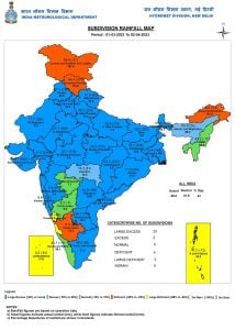 Except western Himalayas, Karnataka and Arunachal Pradesh - most states in India experienced excess pre-monsoon seasonal rains so far[/caption] Current synoptic features influencing weather in India as on 2 April, 2023: • The Western Disturbance as a cyclonic circulation over west Iran and neighbourhood at 5.8 km above mean sea level persists. • The trough in middle tropospheric westerlies with its axis at 5.8 km above mean sea level roughly along Long. 85°E to the north of Lat. 25°N persists. • The cyclonic circulation over West Rajasthan and neighbourhood extending up to 1.5 km above mean sea level persists. • The north-south trough/wind discontinuity from north Chhattisgarh to south interior Tamil Nadu across Telangana and Andhra Pradesh extending up to 1.5 km above mean sea level persists. All India weather forecast for the next week till 8th April • North India: The spring storms will continue to influence northern India early next week as a fresh western disturbance to impact Himalayas and plains. Moderate rains, thundershowers, Hailstorm and gusty winds are expected in Punjab, Haryana, Delhi NCR, Rajasthan and western Uttar Pradesh during 3rd to 5th April, similar weather is expected over Jammu Kashmir, Ladakh, Himachal Pradesh and Uttarakhand with light snowfall over the upper reaches. It is likely to be cooler at the start of April for North India as cloudy and wet weather will keep a hold on rising temperatures till Thursday, once the rain subsides temperatures will start rising significantly over the upcoming weekend. • Central India: March has been an abnormally wet month for central India this time but April will start on a normal note with dry weather conditions prevailing across the week in the states of Gujarat, Maharashtra, Madhya Pradesh and Chhattisgarh. Later in the week both minimum and maximum temperature would rise by 2 to 4°c and the day-time temperatures may reach up to 40°c in certain pockets of Gujarat, a very typical weather of central India during the month of April. • East and North East India: The nor wester have been dominating West Bengal, Jharkhand, Chhattisgarh, Odisha from past 15 days leading to above normal precipitation and below normal temperatures in the region but the upcoming Western Disturbance will keep the rains only restricted to North India, this will ensure a week ahead with clear and dry weather in the states of East India with minimum and maximum temperature to bump up. As the heat builds in pockets of Chhattisgarh, Odisha to experience maximum temperature in the range of 38 to 40°c by the weekend. In the beginning of the week various parts of Meghalaya, Mizoram, Nagaland, Tripura, Assam, Sikkim, Arunachal Pradesh expect cloudy weather and moderate showers but after Wednesday it is expected to get less rainier in these states as well. Southern Peninsula: It’s summer time in south as the April Kicks in, hot and humid afternoons followed by mango showers in the evening is the key feature during this month, following the trend upcoming week is expected to behave similarly with hot afternoons in Telangana, Andhra Pradesh, Tamil Nadu, Kerala and Karnataka with maximum temperature in the range of 35 to 40°c. From 3 to 6 April scattered light to moderate rains are expected in Kerala and Tamil Nadu then reducing to isolated showers towards the weekend. Dry weather conditions will prevail in Telangana, Andhra Pradesh, Karnataka until 6 April but scattered thunderstorms will occur by 7 and 8 April. What will April bring to the table? April is a very crucial month in building up the weather over the country for the upcoming months, weather conditions in April have a great correlation with the monsoon ahead. The monitoring of seasonal heat-low is also a part of weather tracking in this month. The most interesting and dramatic month of the year in meteorological terms is here. The author, better known as the Rohtak Weatherman, interprets and explains complex weather patterns. His impact-based forecasts @navdeepdahiya55 are very popular in north India. Read all the
Latest News
,
Trending News
,
Cricket News
,
Bollywood News
, India News
and
Entertainment News
here. Follow us on
Facebook
,
Twitter
and
Instagram
.
Except western Himalayas, Karnataka and Arunachal Pradesh - most states in India experienced excess pre-monsoon seasonal rains so far[/caption] Current synoptic features influencing weather in India as on 2 April, 2023: • The Western Disturbance as a cyclonic circulation over west Iran and neighbourhood at 5.8 km above mean sea level persists. • The trough in middle tropospheric westerlies with its axis at 5.8 km above mean sea level roughly along Long. 85°E to the north of Lat. 25°N persists. • The cyclonic circulation over West Rajasthan and neighbourhood extending up to 1.5 km above mean sea level persists. • The north-south trough/wind discontinuity from north Chhattisgarh to south interior Tamil Nadu across Telangana and Andhra Pradesh extending up to 1.5 km above mean sea level persists. All India weather forecast for the next week till 8th April • North India: The spring storms will continue to influence northern India early next week as a fresh western disturbance to impact Himalayas and plains. Moderate rains, thundershowers, Hailstorm and gusty winds are expected in Punjab, Haryana, Delhi NCR, Rajasthan and western Uttar Pradesh during 3rd to 5th April, similar weather is expected over Jammu Kashmir, Ladakh, Himachal Pradesh and Uttarakhand with light snowfall over the upper reaches. It is likely to be cooler at the start of April for North India as cloudy and wet weather will keep a hold on rising temperatures till Thursday, once the rain subsides temperatures will start rising significantly over the upcoming weekend. • Central India: March has been an abnormally wet month for central India this time but April will start on a normal note with dry weather conditions prevailing across the week in the states of Gujarat, Maharashtra, Madhya Pradesh and Chhattisgarh. Later in the week both minimum and maximum temperature would rise by 2 to 4°c and the day-time temperatures may reach up to 40°c in certain pockets of Gujarat, a very typical weather of central India during the month of April. • East and North East India: The nor wester have been dominating West Bengal, Jharkhand, Chhattisgarh, Odisha from past 15 days leading to above normal precipitation and below normal temperatures in the region but the upcoming Western Disturbance will keep the rains only restricted to North India, this will ensure a week ahead with clear and dry weather in the states of East India with minimum and maximum temperature to bump up. As the heat builds in pockets of Chhattisgarh, Odisha to experience maximum temperature in the range of 38 to 40°c by the weekend. In the beginning of the week various parts of Meghalaya, Mizoram, Nagaland, Tripura, Assam, Sikkim, Arunachal Pradesh expect cloudy weather and moderate showers but after Wednesday it is expected to get less rainier in these states as well. Southern Peninsula: It’s summer time in south as the April Kicks in, hot and humid afternoons followed by mango showers in the evening is the key feature during this month, following the trend upcoming week is expected to behave similarly with hot afternoons in Telangana, Andhra Pradesh, Tamil Nadu, Kerala and Karnataka with maximum temperature in the range of 35 to 40°c. From 3 to 6 April scattered light to moderate rains are expected in Kerala and Tamil Nadu then reducing to isolated showers towards the weekend. Dry weather conditions will prevail in Telangana, Andhra Pradesh, Karnataka until 6 April but scattered thunderstorms will occur by 7 and 8 April. What will April bring to the table? April is a very crucial month in building up the weather over the country for the upcoming months, weather conditions in April have a great correlation with the monsoon ahead. The monitoring of seasonal heat-low is also a part of weather tracking in this month. The most interesting and dramatic month of the year in meteorological terms is here. The author, better known as the Rohtak Weatherman, interprets and explains complex weather patterns. His impact-based forecasts @navdeepdahiya55 are very popular in north India. Read all the
Latest News
,
Trending News
,
Cricket News
,
Bollywood News
, India News
and
Entertainment News
here. Follow us on
Facebook
,
Twitter
and
Instagram
.
Weather Report: As Delhi experiences record rains in March, another wet week expected across North India
Navdeep Dahiya
• April 3, 2023, 12:13:35 IST
Moderate rains, thundershowers, hailstorm and gusty winds are expected in Punjab, Haryana, Delhi NCR, Rajasthan and Western Uttar Pradesh from Tuesday to Thursday
Advertisement
 "Weather Report: As Delhi experiences record rains in March, another wet week expected across North India")
End of Article