
 "Weather report: Another western disturbance to impact North India from Thursday; heatwaves to abate in East")
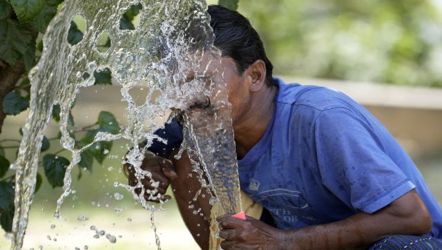
This week has been a typical summer week across the country as East India baked under the influence of the heatwave with maximum temperatures recorded above 40°C for multiple days in a row. For example - Patna in Bihar recorded 44.1°C maximum temperature on 18th April, this is the second highest temperature recorded in the month of April, just after its all time record of 44.6°C from 1980. Similarly, scorching heat continues to impact Prayagraj, the maximum temperature in the past 10 days staying above 40°c. While the heat was restricted to East India other parts of the country saw rain, hails and thunderstorms along with normal to below normal temperature anomaly ensuring no proper summer onset so far in North and Central India however it’s pretty normal for southern peninsula to observe pre-monsoon rains and convective activities during these days of April. Due to strong western disturbance good rainfall was observed in Himachal Pradesh Kothi: 109.0mm Jogindernagar: 91.0mm Manali: 90.0mm Wangtoo: 69.4mm Chamba: 69.0mm Bhuntar: 65.0mm Tissa: 64.0mm Shimla: 60.4mm Rohru: 57.0mm Sangla: 56.8mm Kalpa: 54.8mm Kotkhai: 54.2 mm Reckong Peo: 51.0mm Solan: 31.6mm Dharamshala: 30.9mm On 19th April, Bhuntar airport in Kullu recorded 13.9°C maximum temperature which is 14° below normal. This came after when the maximum temperature at Bhuntar a day before was 29.1°C, the city saw a massive drop of 15.2°C within a day. Manali managed to record a single digit maximum temperature of 9.2°C (14°C below normal). [caption id=“attachment_12497082” align=“alignnone” width=“612”] East India experienced heatwaves and above normal temperature in April 2023 so far, the temperature anomaly in the other regions of the country has stayed below normal[/caption] Cloudy weather, cool winds and isolated rains have dropped temperature on Sunday as the national capital Delhi recorded a maximum temperature of 31.3°C, 6°C below climatology normal. Maximum temperature was in similar range in other cities of plains of North India on 23rd April Chandigarh: 31.1°C Rohtak: 31.2°C Gurgaon: 31.3°C Ludhiana: 31.5°C Meerut: 32.1°C Hisar: 33.5°C Amritsar: 34.4°C Aligarh: 34.8°C Jaipur: 35.8°C Lucknow: 36.8°C As north, central and southern parts of the country continue to receive rainfall the overall pre-monsoon precipitation numbers are stagnant at a positive normal despite East and North East India experiencing very little rains against the standards of the region. In the period of 1st March till 23rd April the country as a whole recorded 62.6 mm rainfall against the normal of 58.7 mm, departure from normal stands at +7 per cent fell from +10 per cent during the last Sunday. Subdivision-wise seasonal rainfall in the period of 1st March till 23rd April, 2023 • Southern Peninsula: Actual 46.1 mm against the average of 39.7 mm, +16 per cent departure from normal. • East and North East India: Actual 115.1 mm against the average of 148.2 mm, -22 per cent departure from normal. • North West India: Actual 73.6 mm against the average of 72.7 mm, +1 per cent departure from normal. • Central India: Actual 37.2 mm against the average of 14.5 mm, +157 per cent departure from normal. [caption id=“attachment_12497102” align=“alignnone” width=“606”]
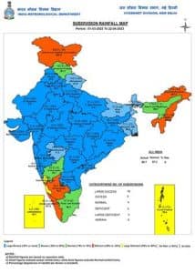 Subdivision wise pre-monsoon rains in India so far till 23rd April, 2023[/caption] Current synoptic weather features influencing weather in India as on 23rd April • A western disturbance as a cyclonic circulation lies over Punjab and neighbourhood in middle tropospheric levels. • A cyclonic circulation lies over Central Madhya Pradesh in lower tropospheric levels. • A trough/wind discontinuity runs from South Chhattisgarh to South Tamil Nadu at lower levels and another trough runs from Sub-Himalayan West Bengal and Sikkim to Chhattisgarh at middle tropospheric levels. • A trough runs roughly along Longitude 90°E to the north of Latitude 20°N in lower tropospheric levels. All India weather forecast till 30th April North India " Expected to become warm before it gets wet again" The pleasant weather seen on the weekend would last on Monday as well but since the impact of western disturbance dismisses temperatures are expected to rise by 4 to 7°C from Tuesday onwards till Thursday. Dry and warm weather with maximum temperature in the range of 36 to 41°C are expected in Punjab, Haryana, Rajasthan, Delhi NCR, Uttar Pradesh till 27 April, at the same time minimum and maximum temperature is expected to rise across Jammu and Kashmir, Himachal Pradesh, and Uttarakhand as rains and cloudy weather decreases significantly. Another active western disturbance along with induced cyclonic circulation to impact entire North India from 27 April into the weekend, this spell will bring in fresh spells of Dust Storm, rains, hails and lightning strikes along with a major drop in temperatures across the northern plains. Himalayan states can expect fresh rounds of snowfall on the upper reaches while moderate to heavy rains and hailstorms in low to middle altitude hills. The upcoming spell is expected to be the beginning of a series of western disturbances anticipated to impact entire North India even in the first week of May, the abnormal wet weather conditions will keep the seasonal heatwave at bay for another 15 days. [caption id=“attachment_12497122” align=“alignnone” width=“615”]
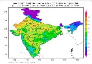 Maximum temperatures are predicted to cross 40 degrees this mid week over North India but rains to bring it down again by the weekend[/caption] East and North East India " Heatwave abated, pleasant weather to roll in" East India faced the harsh summer days for the first three weeks of the month, the weekend brought in some relief from the prolonged heat as rains lashes cities in Bihar, Jharkhand, West Bengal and Odisha, the maximum temperature in most stations fell below 40°C and marked abatement of the heatwave conditions. The upcoming week is expected to start on a similar note, as maximum temperatures are likely in the normal range with scattered rains and thunderstorms generally appearing in the late afternoon to late evening hours, the spread of rains may increase around 28 April when western disturbance to show up in North India this might ensure stronger norwesters for the eastern India during the next weekend. On the other note, North East India is experiencing below normal rains in the ongoing pre-monsoon season so far, the departure from normals are significantly deficient in the seven sister states, the scenario doesn’t seem to change much for the next week as rains are expected to be mainly isolated to scattered in nature with lesser probability of heavy intensity rains. Central India " Wind discontinuity holds strong, more rains in store" The rains which started in March are in no mood to take a break from central India as another wet week is expected in the central parts of the country in the upcoming week. The wind discontinuity continue to persist over Vidarbha region of Maharashtra this is leading to a lot of moisture incursion from Bay of Bengal and Arabian Sea towards the Central India as a result moderate to heavy intensity rains and thundershowers are expected in Vidarbha and Chhattisgarh during 24 to 26th April, the spread of rains will start increasing towards Madhya Pradesh, Gujarat and rest parts of Maharashtra from 27 April as the approaching western disturbance to increase the capability of increasing convection, this leads to thunder cloud development. The maximum temperature is expected in the range of 34 to 38°C across this week in the interiors while it can be as high as 40°C in Konkan and nearby regions, a large part of central India will not experience the typical heatwave for another 10 to 12 days. South India “The pre monsoon rains to get stronger" The much awaited pre-monsoon rains have been observed in many parts of Tamil Nadu, Andhra Pradesh, Telangana and over some parts of Karnataka and Kerala brought respite from dry heat conditions this weekend, the lower level wind discontinuity is expected to strengthen further in the upcoming week this ensures ample amount of moisture flow in the peninsula along with the wind convergence will result in widespread thunderstorms, moderate to heavy rains across Kerala, Tamil Nadu, Andhra Pradesh, Telangana and Karnataka with peak intensity around mid-week. These mango showers will keep a check on rising temperature across the peninsula and heatwave conditions will not exist this week. On a another note, it’s only a month from here when Monsoon starts to enter the basin with first touch point at Andaman and Nicobar island, it is also essential for the seasonal heat low to develop over the Thar desert around this time which generally helps in pulling the monsoon winds inland, with heatwave conditions to remain absent from most parts of country for another 15 days, it is getting very noisy to build connections with the monsoon performance as of now. The unusual weather is what we have got to track for another two weeks, maybe the heatwaves are expected to start a little late but this may not have a direct influence on the monsoon onset since a lot more parameters hold the key, and they are expected to develop in the days to come. In the coming days the uncertainty will unfold. The author, better known as the Rohtak Weatherman, interprets and explains complex weather patterns. His impact-based forecasts @navdeepdahiya55 are very popular in north India. Read all the
Latest News ,
Trending News ,
Cricket News ,
Bollywood News , India News and
Entertainment News here. Follow us on
Facebook,
Twitter and
Instagram.
Maximum temperatures are predicted to cross 40 degrees this mid week over North India but rains to bring it down again by the weekend[/caption] East and North East India " Heatwave abated, pleasant weather to roll in" East India faced the harsh summer days for the first three weeks of the month, the weekend brought in some relief from the prolonged heat as rains lashes cities in Bihar, Jharkhand, West Bengal and Odisha, the maximum temperature in most stations fell below 40°C and marked abatement of the heatwave conditions. The upcoming week is expected to start on a similar note, as maximum temperatures are likely in the normal range with scattered rains and thunderstorms generally appearing in the late afternoon to late evening hours, the spread of rains may increase around 28 April when western disturbance to show up in North India this might ensure stronger norwesters for the eastern India during the next weekend. On the other note, North East India is experiencing below normal rains in the ongoing pre-monsoon season so far, the departure from normals are significantly deficient in the seven sister states, the scenario doesn’t seem to change much for the next week as rains are expected to be mainly isolated to scattered in nature with lesser probability of heavy intensity rains. Central India " Wind discontinuity holds strong, more rains in store" The rains which started in March are in no mood to take a break from central India as another wet week is expected in the central parts of the country in the upcoming week. The wind discontinuity continue to persist over Vidarbha region of Maharashtra this is leading to a lot of moisture incursion from Bay of Bengal and Arabian Sea towards the Central India as a result moderate to heavy intensity rains and thundershowers are expected in Vidarbha and Chhattisgarh during 24 to 26th April, the spread of rains will start increasing towards Madhya Pradesh, Gujarat and rest parts of Maharashtra from 27 April as the approaching western disturbance to increase the capability of increasing convection, this leads to thunder cloud development. The maximum temperature is expected in the range of 34 to 38°C across this week in the interiors while it can be as high as 40°C in Konkan and nearby regions, a large part of central India will not experience the typical heatwave for another 10 to 12 days. South India “The pre monsoon rains to get stronger" The much awaited pre-monsoon rains have been observed in many parts of Tamil Nadu, Andhra Pradesh, Telangana and over some parts of Karnataka and Kerala brought respite from dry heat conditions this weekend, the lower level wind discontinuity is expected to strengthen further in the upcoming week this ensures ample amount of moisture flow in the peninsula along with the wind convergence will result in widespread thunderstorms, moderate to heavy rains across Kerala, Tamil Nadu, Andhra Pradesh, Telangana and Karnataka with peak intensity around mid-week. These mango showers will keep a check on rising temperature across the peninsula and heatwave conditions will not exist this week. On a another note, it’s only a month from here when Monsoon starts to enter the basin with first touch point at Andaman and Nicobar island, it is also essential for the seasonal heat low to develop over the Thar desert around this time which generally helps in pulling the monsoon winds inland, with heatwave conditions to remain absent from most parts of country for another 15 days, it is getting very noisy to build connections with the monsoon performance as of now. The unusual weather is what we have got to track for another two weeks, maybe the heatwaves are expected to start a little late but this may not have a direct influence on the monsoon onset since a lot more parameters hold the key, and they are expected to develop in the days to come. In the coming days the uncertainty will unfold. The author, better known as the Rohtak Weatherman, interprets and explains complex weather patterns. His impact-based forecasts @navdeepdahiya55 are very popular in north India. Read all the
Latest News ,
Trending News ,
Cricket News ,
Bollywood News , India News and
Entertainment News here. Follow us on
Facebook,
Twitter and
Instagram.
The upcoming week is expected to start on a similar note, as maximum temperatures are likely in the normal range, with scattered rains and thunderstorms generally appearing in the late afternoon to late evening hours
Advertisement
End of Article

 "Russian drones over Poland: Trump’s tepid reaction a wake-up call for Nato?")
 "As Russia pushes east, Ukraine faces mounting pressure to defend its heartland")
 "Why Mossad was not on board with Israel’s strike on Hamas in Qatar")
 "Turkey: Erdogan's police arrest opposition mayor Hasan Mutlu, dozens officials in corruption probe")


