
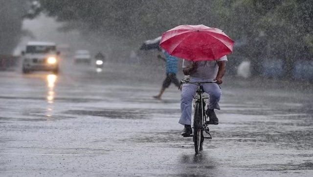
 "Weather Report: Amid humid Delhi and rainy Mumbai, July 2023 is set to become wettest month in recent years")
Monsoon drenched most parts of the core monsoon zone in the past week, extreme rainfall events in a short span resulted in flash floods in certain urban areas of Gujarat, Maharashtra, Madhya Pradesh and Telangana.
Mumbai’s Santacruz observatory hit a double century for the first time in this season by recording 204 mm rainfall till 8:30 AM on 22nd July. Very heavy rains in various other parts of the city resulted in water logging conditions and the city came to standstill for a while.
Observatory/Rainfall
Marol: 215 mm
Vikhroli: 200 mm
Vidyavihar: 186 mm
Juhu: 180 mm
Chembur: 172 mm
Ghatkopar: 169 mm
VileParle: 165 mm
Shiv: 151 mm
Kurla: 150 mm
Bhandup: 146 mm
RamMandir: 127 mm
Mulund: 110 mm
CSMT: 106 mm
Colaba: 103 mm
Heavy to very heavy rainfall in the span of 24 hours in Thane and Navi Mumbai region till 22nd July.
Observatory/Rainfall
Badlapur: 178 mm
Kalyan: 165 mm
Digha: 162 mm
Mumbra: 161 mm
Dombivli: 160 mm
Kausa: 154 mm
Navi Mumbai: 151 mm
Diva: 145 mm
Koprkhairne: 140 mm
Bhayandar: 138 mm
Ambivali: 134 mm
Belapur and Ambernath: 130 mm
Thane and Ulhasnagar: 129 mm
Bhiwandi: 121 mm
India’s financial capital has received 1740 mm seasonal rainfall so far since 1st June, 2023 the four months seasonal average based on past 30 years of climatology is 2450 mm for the period of June till September end.
Quick Reads
View AllWestern ghats take the lead as the offshore trough turns aggressive leading to very heavy rains across past week,
Matheran, a famous hill station in western ghats in the state of Maharashtra, recorded a total of 1403 mm rainfall in the span of seven days.
Day/Rainfall
17 July: 92 mm
18 July: 170 mm
19 July: 343 mm
20 July: 398 mm
21 July: 132 mm
22 July: 111 mm
23 July: 157 mm
Western Ghats and neighbourhood region rainfall on Saturday, 22 July.
Observatory/Rainfall
Mahabaleshwar: 164mm
Matheran: 157mm
Mangalore AP: 140mm
Mangalore Panambur: 130mm
Kannur: 99 mm
Mormugao: 89 mm
Karwara: 78 mm
Panaji: 76 mm
Kolhapura: 48 mm
Stations recording extreme rains in Karnataka ending 8:30 AM on 23 July 2023:
Castle Rock: 281 mm
Bhagamandala: 238 mm
Karkala: 227 mm
Mulki: 223 mm
Udupi: 218 mm
Record-breaking floods hit parts of Gujarat as extremely heavy rains occurred across the state in the past two days. Ahmedabad recorded 159 mm of rainfall in the span of three hours during Saturday evening, leading to water logging in most parts of the city and a flash flood-like situation in the low-lying areas.
Heavy to extremely heavy rainfall figures from different states of Gujarat ending 8:30 AM on 23 July.
Observatory/Rainfall
Navsari: 310 mm
Jalalpor: 280 mm
Khergam: 180 mm
Gandevi: 160 mm
Bharuch: 150 mm
Vagra: 140 mm
Dharampur: 120 mm
Sanand: 110 mm
Chikhli: 110 mm
Dahegam: 100 mm
Pardi: 100 mm
Madhbun: 100 mm
Kaprada: 100 mm
Valod: 90 mm
Umergam: 90 mm
Dolvan: 90 mm
Choryasi: 90 mm
Surat: 90 mm
Mahuva: 90 mm
Virpur: 90 mm
Plains of north India saw decline in rainfall activities towards the second half of the week and sultry weather took over for the first time in this season, High heat index days were observed across north India as moist easterlies are prevailing with less rains in Delhi NCR, Uttar Pradesh, Haryana and parts of Rajasthan.
On 23 June at 5:30 PM the actual temperature at Delhi was reported as 35.6°c with 61 per cent humidity, the real feel is as high as 47° while it was 50° at the peak afternoon leaving residents to survive in the sweat, also frequent power cuts under such weather is becoming another disaster as power demand spikes mid season, this has been a climatology in north India whenever it doesn’t rain high heat index days takes the charge.
Also parts of northeast India along with Bihar, Jharkhand, West Bengal, eastern Uttar Pradesh continue to struggle as monsoon performance remains poor, the axis of monsoon is not moving an inch towards the foothills of Himalayas, some parts of the states are now under drought like conditions.
Monsoon keeps a strong hold over central, southern and western India in the past week and extremely heavy rains ensured pan India rainfall statistics remain positive.
In the period of 1 June till 23 July, India as a whole has received 389.2 mm rainfall against the normal of 370.9 mm, departure from normal stands at +5 per cent compared to week on week of 0 per cent.
Subdivision wise seasonal rainfall till 23 July 2023:
Southern Peninsula: Actual 281.5 mm against the average of 311.2 mm, -10 per cent departure from normal.
East and northeast India: Actual 499.8 mm against the average of 651.4 mm, -23 per cent departure from normal.
Northwest India: Actual 318.8 mm against the average of 227.6 mm, +40 per cent departure from normal.
Central India: Actual 464.0mm against the average of 404.0mm, +15 per cent departure from normal.
Current synoptic weather features influencing weather in India as on 23 July 2023:
The Monsoon Trough at mean sea level now passes through Jaisalmer, Udaipur, Indore, Chhindwara, Raipur, Gopalpur and thence east-southeast words to east-central Bay of Bengal extending up to 1.5 km above mean sea level.
The cyclonic circulation over central Madhya Pradesh extending up to 7.6 km above mean sea level tilting southwards with height persists.
The cyclonic circulation over South Odisha and neighbourhood at 3.1 km above mean sea level persists.
The shear zone roughly along Lat. 20° N between 3.1 and 5.8 km above mean sea level persists.
A cyclonic circulation lies over west central and adjoining northwest Bay of Bengal between 5.8 and 7.6 km above mean sea level. Under its influence, a Low Pressure Area is likely to form over the same region during the next 48 hours.
All India weather forecast till 30 July 2023:
The last week of July is here and Monsoon is in no mood to take a break giving an opportunity for July 2023 to become one of the wettest months in recent years.
Another low pressure area is likely to develop in the Bay of Bengal within next 48 hours and western arm of monsoon is likely to shift northwards this week, under the circumstances good rains are set to return over various parts of northern plains and western Himalayas while central and western parts of the country will continue to experience active monsoon conditions.
Region specific rain predictions for the upcoming week
Northwest India: Light/moderate fairly widespread to widespread rainfall with isolated heavy rainfall is very likely over Himachal Pradesh, Uttarakhand and eastern Rajasthan between 23 and 27 July and over Punjab, Haryana, Chandigarh-Delhi and Uttar Pradesh between 25 and 27 July; over west Rajasthan on 23, 25 and 26 July and Jammu Kashmir-Ladakh-Gilgit-Baltistan-Muzaffarabad on 26 and 27 July 2023.
Central India: Light/moderate fairly widespread to widespread rainfall with isolated heavy rainfall is very likely over the region during 23-27 July 2023.
Isolated very heavy rainfall is also likely over southwest Madhya Pradesh on 23 July and over Chhattisgarh on 26 and 27 July 2023.
West India: Light/moderate fairly widespread to widespread rainfall with isolated heavy to very heavy rainfall very likely to continue over Konkan and Goa and ghat areas of Madhya Maharashtra between 23 and 27 July; over Marathwada on 23 and 24 July and over Gujarat state during 23- 25 July 2023.
Isolated extremely heavy rainfall likely over Ghat areas of Madhya-Maharashtra and Gujarat state on 23 July 2023.
South India: Light/moderate fairly widespread to widespread rainfall with isolated heavy rainfall very likely over Coastal Andhra Pradesh and Yanam, Telangana, Karnataka and Kerala and Mahe during 23-27; over Rayalaseema during 25 -27 and over Tamil Nadu, Pondicherry and Karaikal on 23 and 24 July 2023.
Isolated very heavy rainfall very likely over Coastal Karnataka on 23 and 24 July; over South Interior Karnataka and Kerala and Mahe on 23 July; over coastal Andhra Pradesh and Yanam on 25 and 26 July and overTelangana during 25-27 July.
East India: Light/moderate fairly widespread to widespread rainfall with isolated heavy rainfall very likely over Odisha during 23-27 July and over Andaman and Nicobar Islands on 23 and 24 July 2023.
Isolated very heavy rainfall likely over Odisha during 25-27 July 2023.
Northeast India: Light/moderate fairly widespread rainfall very likely over the region. Isolated heavy rainfall likely over Arunachal Pradesh and Assam and Meghalaya during 23-27 July and over Nagaland, Manipur, Mizoram and Tripura on 23, 26 and 27 July 2023.
The writer, better known as the Rohtak Weatherman, interprets and explains complex weather patterns. His impact-based forecasts @navdeepdahiya55 are very popular in north India. Views expressed in the above piece are personal and solely that of the author. They do not necessarily reflect Firstpost_’s views._
Read all the
Latest News,
Trending News,
Cricket News,
Bollywood News,
India News and
Entertainment News here. Follow us on
Facebook,
Twitter and
Instagram.

 "PM Modi speaks with Venezuela’s Rodríguez, vows to 'expand bilateral partnership' amid US tensions")
 "Congress committed 'grave mistake' by pushing FTA with China, failed deals with Japan and Korea: Goyal")
 "China boosts grip over EV battery minerals with $200 million graphite project in Mozambique")
 "Bangladesh saw 522 communal attacks & 66 deaths in 2025: Rights body rebukes Yunus govt claims")


