
 "Weather report: After hot February, North India is set to experience warmer March first week")
In a blink of an eye February will end, historically been said to be a typical winter month in India, Despite bone chilling cold waves in January unfortunately winter couldn’t continue itself in the month of February. Well multiple factors lead to an abnormally warm month, less winter precipitation both over Himalayas and other parts of the country in absence of strong western disturbances, too early establishment of the anti cyclonic circulation in the western India, all these resulted in record breaking heat across the country in the past 10 days. On 18 February one of the most visited hill stations in India and capital of Himachal Pradesh, Shimla experienced the warmest ever day of the month. It broke the all-time record of highest minimum temperature in the month of February with 14.4°c in the morning, on the same day sets a new all time record for highest ever maximum temperature with 23.2°c. On 20 February National Capital Delhi’s Safdarjung observatory sees the third warmest February day since 1901, records a maximum temperature of 33.6°c, a whopping 9°c above normal, also gets very close to the monthly all time record of 34.1°c from 26 February, 2006. [caption id=“attachment_12211962” align=“alignnone” width=“645”] Unusual heat over most parts of country in February, temperature have been above normal by 2-6 degrees, except south India[/caption] The unusual heat was later tapped down when a western disturbance appeared over western Himalayas on 21-23 February caused light to moderate snowfall over the upper hills while light to moderate rainfall and hailstorm occurred at the lower to mid Himalayas. Famous hill stations like Shimla and Mussoorie experienced snow less winter season was painted white with hails on the evening of 21 February. Precipitation in the span of 24 hours till 8:30 AM on 22nd February; Himachal Pradesh Snowfall; Kalpa: 4.2cm Kufri :1.5cm Narkanda: 1.0cm Rainfall; CPRI: 30.0mm Mashobra: 26.5mm Shimla city: 24.2mm Juber Hatti: 17.1mm Manali: 16.0mm Palampur: 13.6mm Hamirpur: 12.5mm Bilaspur: 9.5mm Reckong Peo: 8.5mm Dharamshala: 7.0mm Solan: 6.4mm Uttarakhand Rainfall; Dhanolti: 21.0mm Dunda: 19.0 mm Chakrata: 16.2 mm Sonprayag: 12.5 mm Ramnagar: 12.0 mm Purola: 10.5mm Uttarkashi & Mori: 10.0mm Chamba: 10.0mm Pantnagar: 8.8mm Ranichauri: 8.6mm Jakholi: 8.8 mm Ghansali: 8.2 mm Tehri: 6.6 mm Dehradun: 5.0 mm Mussoorie: 4.2mm Khatima: 4.0 mm Nainital: 2.0mm Country’s North eastern parts have experienced a very dry winter season but finally spring western disturbances have started impacting these states during the last couple of days with good rainfall. Pasighat in Arunachal Pradesh recorded 45mm rainfall on 23th February which is the highest single day rainfall at least since 2011 in the month of February. Rainfall in the span of 24 hours ending 8:30AM on 23rd February; Meghalaya Khliehriat: 35.0 mm Pynursla: 30.0 mm Shella: 11.0 mm Sohra: 10.8 mm Mawsynram: 10.2 mm RKM: 8.6 mm Nongstoin: 8.0 mm IIT Guwahati: 7.0 mm Mawkyrwat: 1.3 mm Mawphlang: 1.2 mm Assam Tinsukia: 22.0mm Jorhat: 21.8mm North Lakhimpur: 12.9mm Tezpur: 11.7mm Baksa: 6.5mm Arunachal Tezu: 48.8 mm Pasighat: 44.8 mm Tuting: 44.8 mm Kibithu: 36.2 mm Namsai: 25.0 mm Kabubasti: 25.1 mm Daporijo: 16.4 mm Basar: 15.6 mm Miao: 15.4 mn Itanagar: 4.4 mm Sikkim Gangtok: 33.2mm Tadong: 16.0mm Damthang: 15.2mm Mangan: 14.2mm Rongli: 8.2mm Pakyong: 6.2mm Despite a major recovery in rains over the North East India, Country’s winter seasonal rainfall numbers are nearly half way mark to the normal. The pan-India as a whole received 21.7 mm rainfall from 1 January to 26 February against the normal of 37.9mm, departure from normal stands at -43%. Subdivision wise seasonal rainfall from 1 January to 26 February, 2023: • Southern Peninsula: Actual 6.2mm against the average of 15.2mm, -59% departure from normal. • East & North East India: Actual 20.5mm against the average of 44.3mm, -54% departure from normal. • North West India: Actual 54.1mm against the average of 75.2mm, -28% departure from normal. • Central India: Actual 1.9mm against the average of 14.2mm, -87% departure from normal. [caption id=“attachment_12211972” align=“alignnone” width=“439”]
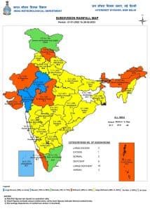 Seasonal rainfall since 1 January, 2023 in various sub-divisions of India have been scanty[/caption] Current synoptic weather features influencing weather in India as on 27th February, 2023: • The Western Disturbance as a trough in middle and upper tropospheric westerlies with its axis at 5.8 km above mean sea level roughly along Long. 65°E to the north of Lat. 32°N persists. • The cyclonic circulation over east Bangladesh and neighbourhood at 1.5 km above mean sea level persists. • A fresh Western Disturbance is likely to affect Western Himalayan Region & adjoining plains of Northwest India from 28th February, 2023. All India weather forecast till 5th of March, 2022: North India: It’s all set to be another warm week for the northern parts of the country with a little change in weather conditions during the mid week. Well the maximum and minimum temperature will still continue to soar as high as 3 to 8°c above normal in Himalayas and states in plains of North India, a fresh moderate western disturbance will peak in during 28th February till 2nd March this will result in fresh round of snowfall at the higher reaches of Kashmir, Himachal Pradesh and Uttarakhand while only Light to moderate rains and hailstorm would occur in Jammu division, lower to mid range Himalayan ranges of Himachal Pradesh and Uttarakhand, the maximum temperature will fall slightly during this period due to enhanced cloudiness in the hilly areas. At the same time under the influence of the western disturbance limited weather activities will turn up in terms of patchy thundershowers in some parts of Punjab, Haryana up to Delhi NCR on 28th February and 1st March, it will be notable that these activities will not occur on a large scale and their impact on temperatures will be marginal only. Expected precipitation accumulation in the states till 5th March: • Himachal Pradesh: 60mm • Jammu Kashmir & Ladakh: 40mm • Uttarakhand: 30mm • Punjab: 10mm • Haryana 2mm • Delhi 1mm • Rajasthan and Uttar Pradesh: 0mm West and Central India: As the anti cyclonic circulation fades away temporarily, the aggression of heat will be less over the upcoming week in the country’s heartland, despite that the maximum temperatures will still be registered above normal by 2 to 5°c as dry weather will still continue to remain dominant only the heat dome is fading away. In General the maximum temperatures in Gujarat, Maharashtra, Madhya Pradesh, Chhattisgarh will be recorded in the range of 33 to 37°c, warm enough in the sunny conditions. In absence of any other weather features, chances of precipitation look negligible for another one week. East and North East India: March is approaching and slowly Nor westers aka Kalbaishakhi starts to impact the eastern states of the country, In the absence of stronger western disturbance the conditions are not met for nor wester in Bihar, Jharkhand, West Bengal and Odisha in the coming week, might be the region have to wait a little longer to experience the first Kalbaishakhi of the season. Sunny and warm weather will continue to prevail in the region and parts in interiors of Odisha can target a maximum temperature up to 40°c in the next week until 5th march. Lately, rains have been showing up in the seven sisters states, March marks the beginning of pre monsoon season for the country’s North East, the average rainfall increases significantly March onwards, not a very strong start but light to moderate showers will occur in a few areas of Arunachal Pradesh, Assam, Sikkim and Meghalaya in the upcoming week with at least 2-3 wet days, pre monsoon season 2022 has been phenomenon for the North East India, as per initial analysis this year might not be as intense but this might mean better rains in later half of the season. Expected precipitation accumulation in the States till 5th March: • Sikkim: 50 mm • Arunachal Pradesh: 30 mm • Assam: 20 mm • Meghalaya: 20 mm • Other states of East and North east: 0 mm South India: It’s the time of year when summer starts to shift gears in the southern peninsula typically over Kerala and later on Mango showers also starts to appear in the evenings bringing in respite from the muggy warm afternoons. The upcoming week will start with typical southern warmth and sunny weather, the rain probability will remain low for the entire week under the absence of any tropical disturbance or lower level wind discontinuity. Hot afternoons are expected in Tamil Nadu, Kerala, Telangana, Andhra Pradesh, Karnataka and Goa with maximum temperature in between 32 to 38°c with possibility of touching 40°c in some parts of Telangana and Andhra Pradesh. As per the recent analysis some rains are predicted to occur in parts of Southern Tamil Nadu and Kerala by the weekend, most likely to be first event of mango showers in the region, post that the delicious mangoes are all set to appear in the market’s of the country the citizens wait for the king of the fruits are about to end by mid March. Pre-monsoon season or say summer season starts on paper from 1 March, 3 month long period is the most crucial and complex time in the atmospheric dynamics when the country heat’s up while at the same time first readings or clarity for the Monsoon season’s starts to assemble. It’s the time of the year when Weathermen start to issue heatwave warnings as well as keep an close eye on any signals that could impact the monsoons and why not, after all, heat and rain are the two most impactful parameters on India’s health, agriculture and economy. The author, better known as the Rohtak Weatherman, interprets and explains complex weather patterns. His impact-based forecasts @navdeepdahiya55 are very popular in north India. Read all the
Latest News ,
Trending News ,
Cricket News ,
Bollywood News , India News and
Entertainment News here. Follow us on
Facebook,
Twitter and
Instagram.
Seasonal rainfall since 1 January, 2023 in various sub-divisions of India have been scanty[/caption] Current synoptic weather features influencing weather in India as on 27th February, 2023: • The Western Disturbance as a trough in middle and upper tropospheric westerlies with its axis at 5.8 km above mean sea level roughly along Long. 65°E to the north of Lat. 32°N persists. • The cyclonic circulation over east Bangladesh and neighbourhood at 1.5 km above mean sea level persists. • A fresh Western Disturbance is likely to affect Western Himalayan Region & adjoining plains of Northwest India from 28th February, 2023. All India weather forecast till 5th of March, 2022: North India: It’s all set to be another warm week for the northern parts of the country with a little change in weather conditions during the mid week. Well the maximum and minimum temperature will still continue to soar as high as 3 to 8°c above normal in Himalayas and states in plains of North India, a fresh moderate western disturbance will peak in during 28th February till 2nd March this will result in fresh round of snowfall at the higher reaches of Kashmir, Himachal Pradesh and Uttarakhand while only Light to moderate rains and hailstorm would occur in Jammu division, lower to mid range Himalayan ranges of Himachal Pradesh and Uttarakhand, the maximum temperature will fall slightly during this period due to enhanced cloudiness in the hilly areas. At the same time under the influence of the western disturbance limited weather activities will turn up in terms of patchy thundershowers in some parts of Punjab, Haryana up to Delhi NCR on 28th February and 1st March, it will be notable that these activities will not occur on a large scale and their impact on temperatures will be marginal only. Expected precipitation accumulation in the states till 5th March: • Himachal Pradesh: 60mm • Jammu Kashmir & Ladakh: 40mm • Uttarakhand: 30mm • Punjab: 10mm • Haryana 2mm • Delhi 1mm • Rajasthan and Uttar Pradesh: 0mm West and Central India: As the anti cyclonic circulation fades away temporarily, the aggression of heat will be less over the upcoming week in the country’s heartland, despite that the maximum temperatures will still be registered above normal by 2 to 5°c as dry weather will still continue to remain dominant only the heat dome is fading away. In General the maximum temperatures in Gujarat, Maharashtra, Madhya Pradesh, Chhattisgarh will be recorded in the range of 33 to 37°c, warm enough in the sunny conditions. In absence of any other weather features, chances of precipitation look negligible for another one week. East and North East India: March is approaching and slowly Nor westers aka Kalbaishakhi starts to impact the eastern states of the country, In the absence of stronger western disturbance the conditions are not met for nor wester in Bihar, Jharkhand, West Bengal and Odisha in the coming week, might be the region have to wait a little longer to experience the first Kalbaishakhi of the season. Sunny and warm weather will continue to prevail in the region and parts in interiors of Odisha can target a maximum temperature up to 40°c in the next week until 5th march. Lately, rains have been showing up in the seven sisters states, March marks the beginning of pre monsoon season for the country’s North East, the average rainfall increases significantly March onwards, not a very strong start but light to moderate showers will occur in a few areas of Arunachal Pradesh, Assam, Sikkim and Meghalaya in the upcoming week with at least 2-3 wet days, pre monsoon season 2022 has been phenomenon for the North East India, as per initial analysis this year might not be as intense but this might mean better rains in later half of the season. Expected precipitation accumulation in the States till 5th March: • Sikkim: 50 mm • Arunachal Pradesh: 30 mm • Assam: 20 mm • Meghalaya: 20 mm • Other states of East and North east: 0 mm South India: It’s the time of year when summer starts to shift gears in the southern peninsula typically over Kerala and later on Mango showers also starts to appear in the evenings bringing in respite from the muggy warm afternoons. The upcoming week will start with typical southern warmth and sunny weather, the rain probability will remain low for the entire week under the absence of any tropical disturbance or lower level wind discontinuity. Hot afternoons are expected in Tamil Nadu, Kerala, Telangana, Andhra Pradesh, Karnataka and Goa with maximum temperature in between 32 to 38°c with possibility of touching 40°c in some parts of Telangana and Andhra Pradesh. As per the recent analysis some rains are predicted to occur in parts of Southern Tamil Nadu and Kerala by the weekend, most likely to be first event of mango showers in the region, post that the delicious mangoes are all set to appear in the market’s of the country the citizens wait for the king of the fruits are about to end by mid March. Pre-monsoon season or say summer season starts on paper from 1 March, 3 month long period is the most crucial and complex time in the atmospheric dynamics when the country heat’s up while at the same time first readings or clarity for the Monsoon season’s starts to assemble. It’s the time of the year when Weathermen start to issue heatwave warnings as well as keep an close eye on any signals that could impact the monsoons and why not, after all, heat and rain are the two most impactful parameters on India’s health, agriculture and economy. The author, better known as the Rohtak Weatherman, interprets and explains complex weather patterns. His impact-based forecasts @navdeepdahiya55 are very popular in north India. Read all the
Latest News ,
Trending News ,
Cricket News ,
Bollywood News , India News and
Entertainment News here. Follow us on
Facebook,
Twitter and
Instagram.
On 20 February Delhi’s Safdarjung observatory marked the third warmest February day since 1901. Another warm week is expected for the northern parts of the country with a little change in weather conditions during the mid-week
Advertisement
End of Article

 "Russian drones over Poland: Trump’s tepid reaction a wake-up call for Nato?")
 "As Russia pushes east, Ukraine faces mounting pressure to defend its heartland")
 "Why Mossad was not on board with Israel’s strike on Hamas in Qatar")
 "Turkey: Erdogan's police arrest opposition mayor Hasan Mutlu, dozens officials in corruption probe")


