The month of January ends on a wet note for most parts of North India where a strong Western Disturbance brought in heavy snowfall over the western Himalayas and Moderate rains were recorded in the plains. January overall has been cooler than normal month for most parts of North, West and Central India, except states in East and some parts southern India where it has been significantly warmer than usual. [caption id=“attachment_12109042” align=“alignnone” width=“505”]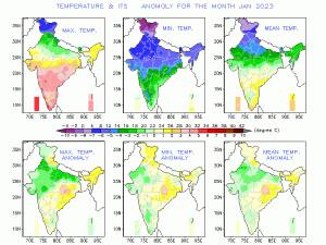 Maximum, Minimum and Mean temperature during the month of January, 2023[/caption] If we analyse data for national capital Delhi maximum temperatures were markedly below normal on 27th and 30th, appreciably below normal on 4th, 5th and 26th, below normal on 3rd, 6th, 7th, 8th, 15th and 16th, appreciably above normal on 24th and above normal on 13th, 20th, 21st, 22nd and 23rd and nearly normal on remaining days of the month. The mean maximum temperature was 19.7°c, which is 0.4°c below its climatological mean for the month, i.e. 20.1°c. The highest maximum temperature was 25.9ºc recorded on the 24th of the month. The all-time record of maximum temperature for the month is 32.5ºc recorded on 28th January 2004. Minimum temperatures were markedly below normal on 8th and 16th, appreciably below normal on 5th, 6th, 7th, 9th,17th, 18th and 27th, below normal on 1st, 4th, 15th, 28th and 29th, appreciably above normal on 20th, 24th and 26th, above normal on 12th, 13th, 14th and 25th and nearly normal on remaining days of the month. The mean minimum temperature during the month was 6.6ºc, which is 0.9ºc below its climatological mean for the month, i.e. 7.5 ºc. The lowest minimum temperature was 1.4ºc recorded on the 16th of the month. The all-time record of minimum temperature for the month is -0.6ºc recorded on 16th January 1935. The cold wave conditions in Delhi were realized for 8 days during January, 2023 (continuous spell of 5 days and 3 days). This number is the highest since 2008, when it was realised for 12 days. Under the influence of the western disturbance earlier in the week heavy snow accumulated all over the western Himalayas. Total snow depth in the month of January, 2023 from Kashmir: Gulmarg: 258.3cm Pahalgam: 212.6cm Kokernag: 162.5cm Qazigund: 146.4cm Kupwara: 42cm Srinagar: 40.5cm Bhaderwah: 21cm Batote: 11cm Total snowfall during the month of January in stations of Himachal Pradesh: Kothi: 172.5cm Gondhla: 150.0cm Khadrala: 133.0cm Sangla: 100.0cm Kalpa: 76.3cm Bharmour: 45.0cm Manali: 27.8cm Shimla: 6.0cm After the passage of the western disturbance a severe cold wave gripped Himalayas, Nyoma in Ladakh recorded -31.0°c on 31 January and -31.9°c on 1 February, 2023. Became the first station in the country to record a minimum temperature below -30°c for the first time in this season. Following good spell of precipitation in Himalayas, plains of North India and in parts of Tamil Nadu and Kerala in South seasonal rainfall figures have improved compared slightly, country as whole received 15.5mm rainfall during 1 January till 5 February against the normal of 19.8mm, departure from normal stands at -22%, came down from -41% on 28th January. Subdivision wise seasonal rainfall in the period of 1 January till 5 February, 2023: • Southern Peninsula: Actual 6.0mm against the average of 8.6mm, -30% departure from normal. • East & North East India: Actual 1.9mm against the average of 21.3mm, -91% departure from normal. • North West India: Actual 43.4mm against the average of 38.8mm, +12% departure from normal. • Central India: Actual 1.9mm against the average of 8.4mm, -78% departure from normal. [caption id=“attachment_12109062” align=“alignnone” width=“511”]
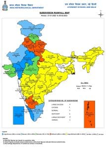 Seasonal rainfall Subdivisions of India till 5th February, 2023[/caption] Current Synoptic features influencing weather in India as on 5 February, 2023: • The Western Disturbance as a trough in middle tropospheric westerlies with its axis at 5.8 km above mean sea level now runs roughly along Long. 56°E to the north of Lat. 30°N. • A fresh Western Disturbance likely to affect the Western Himalayan Region from the night of 8 February, 2023. All India weather forecast till 12th February: North India Two back to back western disturbances to impact Himalayas in the upcoming week. During the period of 6th to 7th February then on 9th till 11th February fresh spell of moderate to heavy snowfall is expected in most parts of mid to upper reaches of Kashmir, Ladakh, Himachal Pradesh and Uttarakhand. Due to cloudy weather and precipitation day temperature’s to be significantly below normal at the hill stations, the wintery conditions will continue to prevail. [caption id=“attachment_12109082” align=“alignnone” width=“531”]
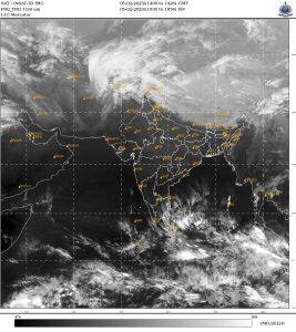 Satellite imagery shows Western disturbance over north Pakistan to impact western Himalayas starting Monday[/caption] An anticyclonic circulation will develop over West India later in the week, this will keep the western disturbance restricted to Himalayas and plains of North India will remain unaffected. Dry weather is expected to prevail in Punjab, Haryana, Delhi NCR, Uttar Pradesh, Rajasthan across the upcoming week. Minimum temperature is expected to rise by 2-3°c while maximum temperature may see a sharp rise of 4-5°c towards next weekend, many parts of Rajasthan can touch maximum temperature up to 35°c while places in Delhi NCR, Haryana, Uttar Pradesh can record up to 30°c, this will be unusually warm for February second week and maximum temperatures can be 4 to 8°c above normal, all thanks to the dry weather under the influence of the anti cyclonic circulation. Maximum temperature recorded as on 4 February already crossing 25 degrees in various stations while parts of Rajasthan are also experiencing maximum temperatures above 30 degrees. Uttar Pradesh Jhansi: 29.4°C Agra: 27.2°C Prayagraj: 26.9°C Kanpur: 25.5°C Haryana Narnaul: 26.0°C Ambala: 24.6°C Chandigarh Airport: 26.6°C City: 24.6°C Punjab Ludhiana: 25.6°C Patiala: 25.4°C Pathankot: 25.1°C Delhi Ridge: 25.9°C Safdarjung: 25.3°C Rajasthan Jalore: 33.0°C Barmer: 32.5°C Jaisalmer: 30.6°C Jodhpur: 30.5°C Phalodi: 30.0°C Bikaner: 29.5°C Dungarpur: 29.4°C Bhilwara: 29.0°C Chittorgarh: 29.0°C Churu: 28.5°C Ajmer: 28.3°C Kota: 28.0°C Pilani: 27.9°C Expected precipitation in North India till 12 February: • Jammu Kashmir, Ladakh: 60mm • Himachal Pradesh: 40mm • Uttarakhand: 20mm Central India: The formation of anti cyclonic circulation near Gujarat will pull warm winds and under the influence of dry conditions, central India is gearing up to experience a warm week ahead, parts of Gujarat, Maharashtra, Madhya Pradesh and Chhattisgarh to experience maximum temperature in the range of 34 to 39°c later in the week, the day time temperatures are all set to shoot above normal marking a very early summer like conditions in country’s heartland. Despite abnormally high temperatures during the day, nights will be slightly pleasant but not cold. The spring is over for central India before it’s even started! East India and North East India: The anti cyclonic near West Bengal will continue to dominate the region for another week, prolonged spell of dry weather will continue to prevail across the seven sisters states along with Bihar, Jharkhand, West Bengal and Odisha to experience sunny and warm afternoon’s, the day time temperatures can reach as high as 36 to 37°c in parts of Odisha, Jharkhand in middle of the week. Usually in the middle of February rains start showing up in the North East specially over Meghalaya and neighbouring states but this year there are no such indications of precipitation in next 10 days. South India: The tropical depression in the bay of Bengal near Sri Lanka is fading away, the Easterlies over the coast of Tamil Nadu is losing strength, dry continental winds to replace the moist winds and dry weather is all set to return in Tamil Nadu, Kerala over the next week. Other parts of Karnataka, Telangana, Andhra Pradesh and Goa will continue to experience dry weather. The summer-like conditions are all set to appear over the southern peninsula in the coming week with maximum temperature to touch 36 to 38°c in various parts of the interior and west coast. The author, better known as the Rohtak Weatherman, interprets and explains complex weather patterns. His impact-based forecasts @navdeepdahiya55 are very popular in north India. Read all the
Latest News
,
Trending News
,
Cricket News
,
Bollywood News
, India News
and
Entertainment News
here. Follow us on
Facebook
,
Twitter
and
Instagram
.
Satellite imagery shows Western disturbance over north Pakistan to impact western Himalayas starting Monday[/caption] An anticyclonic circulation will develop over West India later in the week, this will keep the western disturbance restricted to Himalayas and plains of North India will remain unaffected. Dry weather is expected to prevail in Punjab, Haryana, Delhi NCR, Uttar Pradesh, Rajasthan across the upcoming week. Minimum temperature is expected to rise by 2-3°c while maximum temperature may see a sharp rise of 4-5°c towards next weekend, many parts of Rajasthan can touch maximum temperature up to 35°c while places in Delhi NCR, Haryana, Uttar Pradesh can record up to 30°c, this will be unusually warm for February second week and maximum temperatures can be 4 to 8°c above normal, all thanks to the dry weather under the influence of the anti cyclonic circulation. Maximum temperature recorded as on 4 February already crossing 25 degrees in various stations while parts of Rajasthan are also experiencing maximum temperatures above 30 degrees. Uttar Pradesh Jhansi: 29.4°C Agra: 27.2°C Prayagraj: 26.9°C Kanpur: 25.5°C Haryana Narnaul: 26.0°C Ambala: 24.6°C Chandigarh Airport: 26.6°C City: 24.6°C Punjab Ludhiana: 25.6°C Patiala: 25.4°C Pathankot: 25.1°C Delhi Ridge: 25.9°C Safdarjung: 25.3°C Rajasthan Jalore: 33.0°C Barmer: 32.5°C Jaisalmer: 30.6°C Jodhpur: 30.5°C Phalodi: 30.0°C Bikaner: 29.5°C Dungarpur: 29.4°C Bhilwara: 29.0°C Chittorgarh: 29.0°C Churu: 28.5°C Ajmer: 28.3°C Kota: 28.0°C Pilani: 27.9°C Expected precipitation in North India till 12 February: • Jammu Kashmir, Ladakh: 60mm • Himachal Pradesh: 40mm • Uttarakhand: 20mm Central India: The formation of anti cyclonic circulation near Gujarat will pull warm winds and under the influence of dry conditions, central India is gearing up to experience a warm week ahead, parts of Gujarat, Maharashtra, Madhya Pradesh and Chhattisgarh to experience maximum temperature in the range of 34 to 39°c later in the week, the day time temperatures are all set to shoot above normal marking a very early summer like conditions in country’s heartland. Despite abnormally high temperatures during the day, nights will be slightly pleasant but not cold. The spring is over for central India before it’s even started! East India and North East India: The anti cyclonic near West Bengal will continue to dominate the region for another week, prolonged spell of dry weather will continue to prevail across the seven sisters states along with Bihar, Jharkhand, West Bengal and Odisha to experience sunny and warm afternoon’s, the day time temperatures can reach as high as 36 to 37°c in parts of Odisha, Jharkhand in middle of the week. Usually in the middle of February rains start showing up in the North East specially over Meghalaya and neighbouring states but this year there are no such indications of precipitation in next 10 days. South India: The tropical depression in the bay of Bengal near Sri Lanka is fading away, the Easterlies over the coast of Tamil Nadu is losing strength, dry continental winds to replace the moist winds and dry weather is all set to return in Tamil Nadu, Kerala over the next week. Other parts of Karnataka, Telangana, Andhra Pradesh and Goa will continue to experience dry weather. The summer-like conditions are all set to appear over the southern peninsula in the coming week with maximum temperature to touch 36 to 38°c in various parts of the interior and west coast. The author, better known as the Rohtak Weatherman, interprets and explains complex weather patterns. His impact-based forecasts @navdeepdahiya55 are very popular in north India. Read all the
Latest News
,
Trending News
,
Cricket News
,
Bollywood News
, India News
and
Entertainment News
here. Follow us on
Facebook
,
Twitter
and
Instagram
.
Weather Report: After a cooler January, Delhi NCR to witness an unusually warm February second week
Navdeep Dahiya
• February 6, 2023, 12:29:12 IST
Delhi NCR, Haryana, Uttar Pradesh can record up to 30°c, this will be unusually warm for February second week and maximum temperatures can be 4 to 8°c above normal, all thanks to the dry weather under the influence of the anti cyclonic circulation
Advertisement
 "Weather Report: After a cooler January, Delhi NCR to witness an unusually warm February second week")
End of Article