
 "Weather report: After a record-dry August, hopes are high for September")
August left India parched as the month ended with a -36 per cent rainfall deficit countrywide. El Nino left its impression as it turned out to be the lowest ever pan-India rainfall in the month of August since the record-keeping began by the Indian Meteorological Department in 1901. • All India rainfall during 1 till 31 August, 2023 is recorded as 162.7 mm against the normal of 254.9 mm lowest ever in 123 years on record keeping. • Central India rainfall during 1 till 31 August, 2023 also registered as lowest ever since 1901 by recording a total of 165 mm against the normal of 308.8 mm, also another region, southern peninsula saw 76.4 mm against the normal of 190.7 mm, the lowest ever rain in the last 123 years. Top ten driest August in India as per the climatology records 1. 2023: 162.7 mm 2. 1913: 189.8 mm 3. 2005: 190.1mm 4. 1920: 190.8 mm 5. 2009: 192.5 mm 6. 2021: 196.2 mm 7. 1993: 198.8 mm 8. 1979: 199.3 mm 9. 1902 and 1905: 202.6 mm 10. 2015: 204.2 mm Out of the total driest months, five have been witnessed in the last 20 years attributed to changing dynamics of monsoon as August gets prone to longer breaks in monsoon. Key cities rainfall performance during August, 2023: • Delhi had its second driest August in the last 14 years. For the second year in a row rainfall in Delhi in August is less than 100 mm. • Mumbai experienced fifth driest August ever, 1) 108.6 mm in 1972 2) 122.9 mm in 1966 3) 153.9 mm in 2015 4) 173.1 mm in 1999 5) 177.2 mm in 2023 • Bangalore recorded just 12.6 mm rainfall in the entire month thus making it the driest ever in the history, Broke the previous monthly all time record of 20.6 mm set way back in 1885. Bengaluru city reported a minimum temperature of 22.9°C making it the warmest August morning in recorded history; the previous highest minimum temperature was 22.5°C observed on the 23 August 1995. • Break in monsoon conditions favour Chennai to experience heavy rain, city’s Nungabakkam observatory recorded 276 mm in the month of August, it became the second wettest August since 2000, The south west monsoon total stands at 542 mm in the city. [caption id=“attachment_13074432” align=“alignnone” width=“768”] Rainfall statistics for the entire monsoon 2023 till 3 September, 2023[/caption] Ahead of a fresh low pressure area that is expected to form up in Bay of Bengal, monsoon has started its revival over east India along with southern peninsula under the presence of moist easterlies winds trigger thunderstorms and wind discontinuity in peninsula leading to convective development over the weekend. Rainfall ending 8:30 am on Sunday morning in few major cities: Vijayawada: 59 mm Bhubaneswar: 47 mm Madurai: 45 mm Mumbai Colaba: 35 mm Hyderabad: 29 mm Kolkata: 28 mm Kochi: 20 mm Patna: 18 mm Raipur: 13 mm Trivandrum: 12 mm However, under the influence of anti-cyclonic circulation, dry and hot winds have been blowing across the northwest and western India. Maximum temperature reported on Saturday afternoon at a few major cities; Hisar: 39°C Jaipur: 37.2°C New Delhi: 37.2°C Lucknow: 37°C Patiala: 37°C Amritsar: 36°C Chandigarh: 35.2°C Drought prone areas of Karnataka received good rains ending 8:30 am on 3 September 2023: Kolar: 89.5 mm Chamarajanagar: 78 mm Chikkaballapura: 73 mm Bengaluru Rural: 65.5 mm Tumkur: 61 mm Mysore: 55 mm Mandya: 48 mm Chikkamagaluru: 37 mm Hassan: 30.5 mm Gadag: 26 mm Bengaluru Urban: 25 mm As on 3 September, the seasonal rainfall over pan India stands at an actual of 639.1 mm against the normal of 721.1 mm the departure from normal stands at -11 per cent compared to week on week of -7 per cent, fell by another 4 per cent. Subdivision wise seasonal rainfall in the period of 1 June till 3 September 2023: • Southern Peninsula: Actual 490.1 mm against the average of 571.8 mm, -14 per cent departure from normal. • East and North East India: Actual 914.6 mm against the average of 1112.5 mm, -18 per cent departure from normal. • North-West India: Actual 500.8 mm against the average of 500.2 mm, +0 per cent departure from normal. • Central India: Actual 722.0 mm against the average of 824.5 mm, -12 per cent departure from normal. [caption id=“attachment_13074442” align=“alignnone” width=“722”]
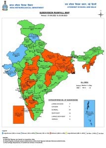 Subdivision wise seasonal rainfall in India during the period of 1 June till 3 September 2023[/caption] Current synoptic weather features influencing weather in India as on 3 September 2023: • The Monsoon Trough at mean sea level continues to run along the foothills of the Himalayas. • The cyclonic circulation over Northeast Bay of Bengal and neighbourhood extending up to 5.8 km above mean sea level persists. Under its influence, a low pressure area is likely to form over northwest and adjoining west central Bay of Bengal during next 48 hours. • The trough from the cyclonic circulation over northeast Bay of Bengal to north Coastal Andhra Pradesh between 1.5 and 3.1 km above mean sea level persists. • The cyclonic circulation over northwest Uttar Pradesh and neighbourhoods between 1.5 and 3.1 km above mean sea level persists. • The cyclonic circulation over Interior Odisha between 4.5 and 7.6 km above mean sea level persists. • The cyclonic circulation over Andhra Pradesh and adjoining Telangana between 4.5 and 5.8 km above mean sea level persists. All India weather forecast till 10 September 2023: After a disastrous dry August where farmers’ crops saw the burnt of low rains, September comes up with the hope of some recovery. The positive Indian ocean dipole (IOD) might offset the influence of El Nino this month. Finally a low pressure area is expected to develop in the western bay of the bay next to the odisha coast by 5th September and move inwards across next week. Similarly, reacting to the development in the sea, the axis of monsoon over land will start fluctuating and leave the foothills of Himalayas; this will trigger the flow of moist easterly winds across eastern India along with parts of north-west India by 5 September. States/UTs to experience above normal to excess rains till 10 September (100-300 mm): • Odisha, West Bengal, Jharkhand, Bihar, Chhattisgarh, Odisha, Telangana, Andhra Pradesh, Karnataka, Kerala. States/UTs to experience normal rains till 10 September (50-150 mm): • Uttar Pradesh, Maharashtra, Tamil Nadu, Goa, Meghalaya, Mizoram, Manipur, Nagaland, Tripura, Assam, Sikkim, Arunachal Pradesh. States/UTs to experience below normal rains till 10 September (0.1 - 50 mm): • Jammu, Kashmir, Ladakh, Himachal Pradesh, Uttarakhand, Punjab, Haryana, Chandigarh, Rajasthan and Gujarat. The strong revival of monsoon will bring relief for the farmers of east and central India, however hot and mainly dry weather conditions over the upcoming week will disappoint farmers in north-west India. The writer, better known as the Rohtak Weatherman, interprets and explains complex weather patterns. His impact-based forecasts @navdeepdahiya55 are very popular in north India. Views expressed in the above piece are personal and solely that of the author. They do not necessarily reflect Firstpost_’s views._ Read all the
Latest News ,
Trending News ,
Cricket News ,
Bollywood News , India News and
Entertainment News here. Follow us on
Facebook,
Twitter and
Instagram.
Subdivision wise seasonal rainfall in India during the period of 1 June till 3 September 2023[/caption] Current synoptic weather features influencing weather in India as on 3 September 2023: • The Monsoon Trough at mean sea level continues to run along the foothills of the Himalayas. • The cyclonic circulation over Northeast Bay of Bengal and neighbourhood extending up to 5.8 km above mean sea level persists. Under its influence, a low pressure area is likely to form over northwest and adjoining west central Bay of Bengal during next 48 hours. • The trough from the cyclonic circulation over northeast Bay of Bengal to north Coastal Andhra Pradesh between 1.5 and 3.1 km above mean sea level persists. • The cyclonic circulation over northwest Uttar Pradesh and neighbourhoods between 1.5 and 3.1 km above mean sea level persists. • The cyclonic circulation over Interior Odisha between 4.5 and 7.6 km above mean sea level persists. • The cyclonic circulation over Andhra Pradesh and adjoining Telangana between 4.5 and 5.8 km above mean sea level persists. All India weather forecast till 10 September 2023: After a disastrous dry August where farmers’ crops saw the burnt of low rains, September comes up with the hope of some recovery. The positive Indian ocean dipole (IOD) might offset the influence of El Nino this month. Finally a low pressure area is expected to develop in the western bay of the bay next to the odisha coast by 5th September and move inwards across next week. Similarly, reacting to the development in the sea, the axis of monsoon over land will start fluctuating and leave the foothills of Himalayas; this will trigger the flow of moist easterly winds across eastern India along with parts of north-west India by 5 September. States/UTs to experience above normal to excess rains till 10 September (100-300 mm): • Odisha, West Bengal, Jharkhand, Bihar, Chhattisgarh, Odisha, Telangana, Andhra Pradesh, Karnataka, Kerala. States/UTs to experience normal rains till 10 September (50-150 mm): • Uttar Pradesh, Maharashtra, Tamil Nadu, Goa, Meghalaya, Mizoram, Manipur, Nagaland, Tripura, Assam, Sikkim, Arunachal Pradesh. States/UTs to experience below normal rains till 10 September (0.1 - 50 mm): • Jammu, Kashmir, Ladakh, Himachal Pradesh, Uttarakhand, Punjab, Haryana, Chandigarh, Rajasthan and Gujarat. The strong revival of monsoon will bring relief for the farmers of east and central India, however hot and mainly dry weather conditions over the upcoming week will disappoint farmers in north-west India. The writer, better known as the Rohtak Weatherman, interprets and explains complex weather patterns. His impact-based forecasts @navdeepdahiya55 are very popular in north India. Views expressed in the above piece are personal and solely that of the author. They do not necessarily reflect Firstpost_’s views._ Read all the
Latest News ,
Trending News ,
Cricket News ,
Bollywood News , India News and
Entertainment News here. Follow us on
Facebook,
Twitter and
Instagram.
The positive Indian ocean dipole (IOD) might offset the influence of El Nino this month
Advertisement
End of Article

 "Russian drones over Poland: Trump’s tepid reaction a wake-up call for Nato?")
 "As Russia pushes east, Ukraine faces mounting pressure to defend its heartland")
 "Why Mossad was not on board with Israel’s strike on Hamas in Qatar")
 "Turkey: Erdogan's police arrest opposition mayor Hasan Mutlu, dozens officials in corruption probe")


