
 "Weather Report: Absence of Western Disturbance to result in dry conditions this week across India")
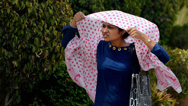
Southern India experienced a major spell of rains in the past week under the influence of Cyclone Michaung, which was the third cyclone of the season in the Bay of Bengal so far in the post-monsoon/north-east monsoon season. Tropical Cyclone Michaung was a powerful example of a storm that faced minimal obstacles during its formation, getting stuck between subtropical ridges close to the coast. Although its main path was towards Andhra Pradesh, Michaung moved slowly near Chennai, causing a significant impact in the region. This cyclone was quite a puzzle for numerical weather models and meteorologists, starting its journey over the South Andaman Sea. The complexity of atmospheric dynamics and the influence of successive westerly troughs over Northern India kept the projected track changing regularly in the model runs due to alterations in ridge positions. Despite the daily fluctuations in model outputs, a combination of model ensembles managed to predict its likely path through trend analysis. [caption id=“attachment_13488272” align=“alignnone” width=“640”] Observed tracks of tropical weather systems in post monsoon season 2023[/caption] Since the beginning, Cyclone Michaung had favourable conditions – a strong Madden-Julian Oscillation in phases 3 and 4, moist easterlies from the South China Sea, and low vertical wind shear. These factors led to rapid intensification near the coast, consolidating the storm by 3 December. Positioned near North Coastal Tamil Nadu, the cyclone barely moved, trapped between subtropical ridges. On the night of 3 December, the western band of the storm expanded over KTCC districts, starting a continuous spell of rain. Intense cells embedded in the western quadrant resulted in heavy downpours in Chennai and nearby areas, with wind gusts reaching 90 km/h. This persistent rainfall was fueled by increased upper-level divergence caused by an incoming Westerly Trough over Northern India. Chennai and surrounding areas experienced exceptional rainfall, reaching 500 mm or more in just 2.5 days, leading to severe flooding. As Cyclone Michaung moved northwestward and made landfall over South Andhra Pradesh, the expectation is for a gradual reduction in rainfall over Chennai – a considerable relief for the city and its surroundings during the latter half of the week; however, waterlogging is persisting in certain parts of the city, causing hassle for citizens. [caption id=“attachment_13488372” align=“alignnone” width=“859”]
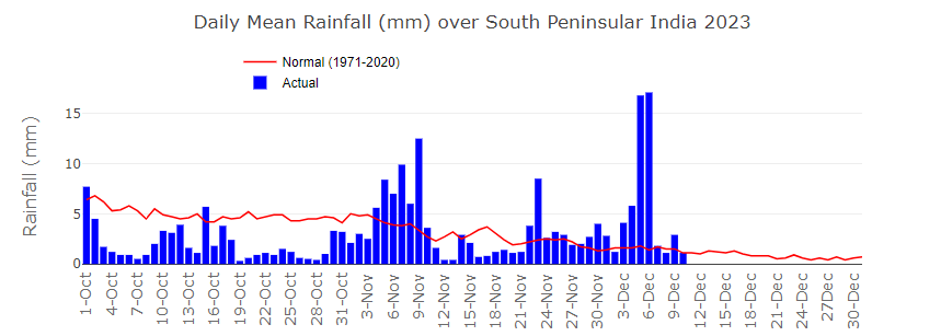 Daily mean rainfall in the south peninsula was significantly above normal during 3rd till 6 December amid cyclone impact[/caption] It’s not just the south, but low-pressure areas led to light to moderate rains in parts of Telangana, Chhattisgarh, Odisha, Jharkhand and West Bengal during the midweek. Overcast conditions have also led to a drop in day temperature to below normal levels. The pan-India actual rainfall so far in the period from 1 October to 10 December stands at 106.7mm against the normal of 110.2mm. The departure from normal currently stands at -3%. The rainfall deficiency has improved by 13% week over week and excess rains in South India lead to a major shift in numbers. Subdivision-wise seasonal rains till 10 December 2023: Southern Peninsula: Actual 220.6mm against the average of 257.3mm, -14% departure from normal. East & North East India: Actual 172.7mm against the average of 149.4mm, +16% departure from normal. North West India: Actual 51.7mm against the average of 36.5mm, +42% departure from normal. Central India: Actual 59.3mm against the average of 73.2mm, -19% departure from normal. [caption id=“attachment_13488432” align=“alignnone” width=“640”]
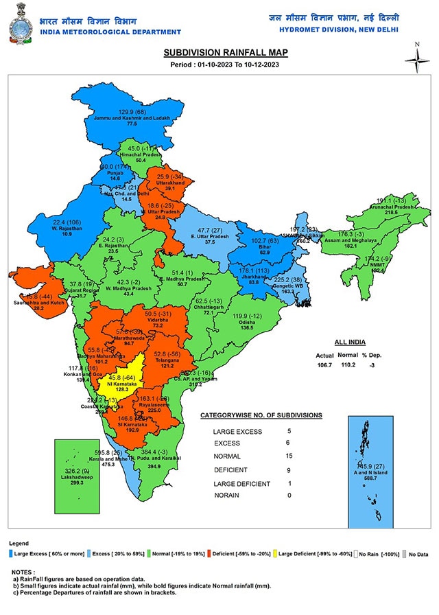 Subdivision wise seasonal rainfall in India as on 10 December, 2023[/caption] Winter tightens grips, north west winds and clear skies are prevailing across western Himalayas and plains of north India as a result night temperatures have registered a significant fall. Srinagar recorded -4.6°c minimum temperature today, which is 4° below normal, also season’s lowest. Nyoma in Ladakh freezes at -18.7°c on Saturday. Sundernagar in Himachal Pradesh recorded 2.1°c, Bhuntar (Kullu) 1.6°c, Solan 2.0°c, Una 4.2°c respectively. In plains, a few stations saw sub 5°C minimum temperature for the first time; Fatehpur in Sikar district of Rajasthan reported 4.5°c. Adampur in Jalandhar district of Punjab reported 4.9°c on Saturday morning. National capital New Delhi experienced the coldest morning of the season on Sunday as minimum temperature at Safdarjung observatory was 8.3°c and the maximum temperature was 23.4°c, both were a degree below normal. [caption id=“attachment_13488532” align=“alignnone” width=“640”]
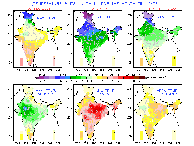 Despite season’s lowest temperatures at multiple places December min temperature anomaly continue to stay above normal across India[/caption] Current synoptic weather features influencing weather in India as of 10 December, 2023: The Cyclonic Circulation over the Southeast Arabian Sea & adjoining Maldives area, extending up to 5.8 km above mean sea level, persists. A fresh, feeble Western Disturbance is likely to affect the Western Himalayan Region from 11 December. All India weather forecast until 17 December, 2023: The northeast monsoon lost track as Cyclone Michaung soaked the entire moisture flow from the Bay of Bengal and dissipated. However, dry weather conditions are a much-needed relief in the flooded regions of Tamil Nadu and Andhra Pradesh. Easterly winds are expected to stay weak for another week, keeping rains away from the peninsula. Mostly dry weather conditions will prevail in Andhra Pradesh, Telangana, Karnataka, Goa, and Tamil Nadu. Isolated light to moderate rains are expected only in parts of Kerala from Monday to Wednesday. North and central India brace for colder nights: Amid the flow of dry and cold northwest winds, nights are likely to be colder in the plains of North India. Many stations in Jammu, Kashmir, Himachal Pradesh, Uttarakhand, Punjab, Haryana, Rajasthan, Delhi NCR, Uttar Pradesh, Bihar, Madhya Pradesh, Jharkhand and Chhattisgarh will experience the season’s lowest minimum temperature during the upcoming week from Tuesday to Friday. Certain parts of Punjab, West Haryana, and North Rajasthan will also reel under Coldwave conditions, with minimum temperatures dropping as low as 4°C. Expected range of minimum and maximum temperature in the states until 17 December, 2023: Punjab: 3 to 10°C, 20 to 25°C. Haryana: 5 to 11°C, 22 to 26°C. Delhi NCR: 7 to 12°C, 23 to 27°C. Uttar Pradesh: 7 to 12°C, 23 to 28°C. Rajasthan: 3 to 13°C, 25 to 31°C. Gujarat: 11 to 17°C, 26 to 34°C. Madhya Pradesh: 9 to 12°C, 26 to 33°C. Maharashtra: 8 to 18°C, 28 to 36°C. Chhattisgarh: 9 to 14°C, 27 to 33°C. Bihar: 7 to 12°C, 25 to 31°C. Jharkhand: 10 to 14°C, 27 to 32°C. West Bengal: 10 to 18°C, 28 to 34°C. Odisha: 9 to 15°C, 28 to 34°C. Northeast India: 8 to 14°C, 21 to 34°C. The Western Disturbance is expected to remain absent for the entire week, resulting in dry weather conditions across the north, central, west and east India. Additionally, dry winds won’t allow dense fog formation to take place for another week, ensuring that the maximum temperature will not register any major drop at least until 15 December. The writer, better known as the Rohtak Weatherman, interprets and explains complex weather patterns. His impact-based forecasts @navdeepdahiya55 are very popular in north India. Views expressed in the above piece are personal and solely those of the author. They do not necessarily reflect Firstpost_’s views._ Read all the
Latest News ,
Trending News ,
Cricket News ,
Bollywood News , India News and
Entertainment News here. Follow us on
Facebook,
Twitter and
Instagram.
Despite season’s lowest temperatures at multiple places December min temperature anomaly continue to stay above normal across India[/caption] Current synoptic weather features influencing weather in India as of 10 December, 2023: The Cyclonic Circulation over the Southeast Arabian Sea & adjoining Maldives area, extending up to 5.8 km above mean sea level, persists. A fresh, feeble Western Disturbance is likely to affect the Western Himalayan Region from 11 December. All India weather forecast until 17 December, 2023: The northeast monsoon lost track as Cyclone Michaung soaked the entire moisture flow from the Bay of Bengal and dissipated. However, dry weather conditions are a much-needed relief in the flooded regions of Tamil Nadu and Andhra Pradesh. Easterly winds are expected to stay weak for another week, keeping rains away from the peninsula. Mostly dry weather conditions will prevail in Andhra Pradesh, Telangana, Karnataka, Goa, and Tamil Nadu. Isolated light to moderate rains are expected only in parts of Kerala from Monday to Wednesday. North and central India brace for colder nights: Amid the flow of dry and cold northwest winds, nights are likely to be colder in the plains of North India. Many stations in Jammu, Kashmir, Himachal Pradesh, Uttarakhand, Punjab, Haryana, Rajasthan, Delhi NCR, Uttar Pradesh, Bihar, Madhya Pradesh, Jharkhand and Chhattisgarh will experience the season’s lowest minimum temperature during the upcoming week from Tuesday to Friday. Certain parts of Punjab, West Haryana, and North Rajasthan will also reel under Coldwave conditions, with minimum temperatures dropping as low as 4°C. Expected range of minimum and maximum temperature in the states until 17 December, 2023: Punjab: 3 to 10°C, 20 to 25°C. Haryana: 5 to 11°C, 22 to 26°C. Delhi NCR: 7 to 12°C, 23 to 27°C. Uttar Pradesh: 7 to 12°C, 23 to 28°C. Rajasthan: 3 to 13°C, 25 to 31°C. Gujarat: 11 to 17°C, 26 to 34°C. Madhya Pradesh: 9 to 12°C, 26 to 33°C. Maharashtra: 8 to 18°C, 28 to 36°C. Chhattisgarh: 9 to 14°C, 27 to 33°C. Bihar: 7 to 12°C, 25 to 31°C. Jharkhand: 10 to 14°C, 27 to 32°C. West Bengal: 10 to 18°C, 28 to 34°C. Odisha: 9 to 15°C, 28 to 34°C. Northeast India: 8 to 14°C, 21 to 34°C. The Western Disturbance is expected to remain absent for the entire week, resulting in dry weather conditions across the north, central, west and east India. Additionally, dry winds won’t allow dense fog formation to take place for another week, ensuring that the maximum temperature will not register any major drop at least until 15 December. The writer, better known as the Rohtak Weatherman, interprets and explains complex weather patterns. His impact-based forecasts @navdeepdahiya55 are very popular in north India. Views expressed in the above piece are personal and solely those of the author. They do not necessarily reflect Firstpost_’s views._ Read all the
Latest News ,
Trending News ,
Cricket News ,
Bollywood News , India News and
Entertainment News here. Follow us on
Facebook,
Twitter and
Instagram.
As Cyclone Michaung moved northwestward and made landfall over South Andhra Pradesh, the expectation is for a gradual reduction in rainfall over Chennai – a considerable relief for the city
Advertisement
End of Article

 "Russian drones over Poland: Trump’s tepid reaction a wake-up call for Nato?")
 "As Russia pushes east, Ukraine faces mounting pressure to defend its heartland")
 "Why Mossad was not on board with Israel’s strike on Hamas in Qatar")
 "Turkey: Erdogan's police arrest opposition mayor Hasan Mutlu, dozens officials in corruption probe")


