
 "Warm December: Why winter is so late this year")
It is past mid-December already and the proper winter chill is yet to be felt in India, the Himalayas are snowless, plains of north India are waiting for the first spell of winter rains to break the two months prolonged spell of dry weather conditions hence the temperatures are preferring to stay above normal till now. Let’s deep dive to know the reasons why we aren’t shivering in winter so far: Delayed monsoon withdrawal makes the winters late? The La Nina patterns are well known when it comes to the summers, it brings long wet spells in the country during the months of monsoon. Parts of North India usually escape the monsoon rains after mid-September but in 2022 it stretched long until 13 October when the monsoon withdrawal started from northern India and dry weather conditions prevailed. After the withdrawal of the monsoon, anti-cyclonic circulation forms over western parts of the country which causes dry weather and restricts any kind of precipitation to pass through the region and it takes up to months to get back to the low pressure/ Front systems such as Western Disturbance to hit the region after a high-pressure area dilutes. Currently, the anti-cyclonic circulation is still existing over Gujarat leading to dry weather conditions - hence a delayed withdrawal of the monsoon can lead to an overall delay in the climatological process. This year the southwest monsoon has withdrawn from the entire country on 23 October against the normal of 15 October. [caption id=“attachment_11844781” align=“alignnone” width=“640”] Map: Withdrawal of the southwest monsoon delayed in 2022[/caption] What is the impact of La Nina over the Indian subcontinent in the winters? La Nina is a weather phenomenon that is characterised by the cooling of surface waters in the tropical Pacific Ocean. It typically occurs every few years and is the opposite of El Nino, which is characterized by the warming of the tropical Pacific Ocean. It is very evident that La Nina brings a pattern of prolonged wetness in India during the South West Monsoon when the country observes normal to above-normal rainfall across various parts. However, during the winter season, the impact of La Nina on India can vary depending on the region and vary on the state level. In general, La Nina can lead to below-average rainfall and above-average temperatures in some parts of the country, while other areas may experience cooler and wetter conditions. The northwest region of India (including the states of Punjab, Haryana, Rajasthan, Uttar Pradesh, Delhi and the Himalayas) has a probability to experience drier and warmer conditions, while the southern and central parts of the country may see increased rainfall and cooler temperatures. As a result, drier than normal rainfall has been observed in most parts of North West India till 15 December, also unseasonal wet weather conditions have influenced parts of Central India in the past week. Model assessment indicates that La Nina is very likely to continue, with about a 75 per cent probability, during December-February 2022-23. The chance of ENSO-neutral is about 25 per cent and for El Nino is near-zero. For January-March 2023, the probability for La Nina decreases to about 60 per cent. [caption id=“attachment_11844891” align=“alignnone” width=“640”]
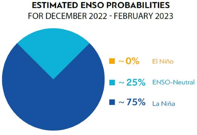 Estimated ENSO probabilities during winter 2022-23 indicate 75% chances of La Nina hold[/caption] As a result, dry weather conditions will be prevailing in large parts of North India to last till December end until other important factors come into play and may result in some rains. What is Arctic Oscillation and impact over India in the Winters? The Arctic Oscillation (AO) is a climate pattern that describes the fluctuation of atmospheric pressure between the polar region and mid-latitudes. The AO is characterised by two opposite phases: the positive phase and the negative phase. During the positive phase of the Arctic Oscillation, atmospheric pressure is higher than average over the polar region and lower than average over mid-latitudes. This can lead to mild and dry conditions in the mid-latitudes as well as reduced sea ice in the Arctic. During the negative phase of the Arctic Oscillation, atmospheric pressure is lower than average over the polar region and higher than average over mid-latitudes. This can lead to cold and wet conditions in the mid-latitudes and increased sea ice in the Arctic. The Arctic Oscillation (AO) is currently strongly negative and is predicted to remain negative to weakly negative the next two weeks as pressure/geopotential height anomalies across the Arctic are predicted to remain positive first mostly in the North Atlantic sector and then mostly in the North Pacific sector. The North Atlantic Oscillation (NAO) is currently negative and is predicted to remain negative the next two weeks as pressure/geopotential height anomalies are predicted to be positive to strongly positive across Greenland. The Arctic Oscillation can affect the strength of the Western Disturbance by influencing the strength of the westerly winds that the disturbance travels through. When the Arctic Oscillation is in a positive phase, the westerly winds are stronger, which can lead to a stronger Western Disturbance. Conversely, when the Arctic Oscillation is in a negative phase, the westerly winds are weaker, which can lead to a weaker Western Disturbance. The current state of Arctic Oscillation is only letting weak Western Disturbance impact North India that to restricting them to the Himalayas only, so far in December plains of North India are bone dry while at least 1 strong Western Disturbance usually makes an appearance in this period. What is the importance of Western Disturbance during winters? A Western Disturbance is an extratropical storm or a cold front system that originates from the Mediterranean, Caspian and the Black sea. It moves from West to East with moisture carried on mid to upper atmosphere and also embedded in the mid-latitude subtropical westerly jet stream. In India, the impact is observed annually but with more dedication during the winter months when they are the only source of snowfall over the Himalayas and rains in the plains of north India. It has great importance in agriculture particularly in Rabi crops. Parts of Jammu and Kashmir experienced moderate snowfall during mid-November when two back-to-back moderate Western Disturbance affected the region. Since then most parts of North West India experience dry and clear weather conditions, usually around mid-December frequency and strength of western disturbances starts to increase, this time around due to strong negative Arctic Oscillation western disturbances have remained distant leading to below normal precipitation across North West India. How are the current temperatures in India? The average maximum, minimum and mean temperature were above normal by 0.34°C, 0.29°C, 0.31°C respectively for the country as a whole in the month of November. Also north east India experienced the warmest November ever since 1901 with the average maximum temperature of 29.06°c. Following the trend December is been very warm so far, especially in terms of maximum temperature, India’s financial capital Mumbai observed 35.5°c maximum temperature on 16 December which is 3°c above normal, while the minimum temperature on 17 December is 23.4°c stands at 5°c above normal, winter chill is completely missing from parts of Central and West India. In North India the minimum temperatures have started falling, Delhi on Saturday morning experienced the coldest morning of the season so far with a 6.0°C minimum temperature while the maximum temperature is 24.5°C still a few notches above normal. The absence of cloudy and wet weather is resulting in a high diurnal range over the low to mid-Himalayan ranges, since the clear skies are prevailing night temperatures are low but sunny conditions in the day time is leading to higher than normal maximum temperatures. Maximum and minimum temperatures in some stations of Himachal Pradesh on 13 December, the differences(diurnal range) is above 20°C: Una 28.6°C/4.7°C Solan 26.0°C/2.6°C Sundernagar 24.5°C/1.4°C Mandi 23.2°C/2.1°C Bhuntar AP 22.4°C/1.1°C [caption id=“attachment_11845811” align=“alignnone” width=“640”]
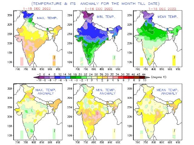 Temperature anomalies in the month of December so far has been way higher than normal[/caption] What are the winter phases in India? The winter phase in India is divided into 3 phases based on the temperature anomalies. • Pre-peak winter: 20 November till 20 December is when the temperature starts to dip and winter chill starts setting in various parts of the country in early December onwards, usually pre-peak has weakened to moderate Western Disturbances. However, this year under the absence of wet weather, this phase has been fairly below normal in terms of precipitation and above normal in terms of maximum temperature. Anyhow cold wave conditions have started in some parts of Punjab, Haryana and Rajasthan and will continue till 20 December. • Peak Winter: 20 December till 20 January, this is the peak period of the wintery conditions in the country when most states see the lowest temperatures and the wet conditions as at least 2 to 3 strong Western Disturbances approach the Himalayas in the period. This year due to the strong influence of negative AO, the start of the peak winters will be dull in terms of rains, snowfall to be below normal, above normal maximum temperatures to be observed but nights will be cold which may lead to below normal minimum temperatures. The negative AO will start weakening in January which might result in Western Disturbances as the month progresses in the second half. • Post Peak Winter: 20 January till 20 February, this period is when temperatures usually start rising but cold conditions stay with the frequency of Western Disturbances are also on a higher side with at least 3 to 4 strong WDs. The delayed trend this year is indicating India to experience above normal rains, snowfall and very cold weather conditions in the post-peak phase as negative AO conditions will start fading away by the time, also weakening of La Nina would result in higher frequency of Western Disturbances in the later phase of winters. What is the intensity of cold waves and fog in December so far? Another crucial factor fog which results in the fall of day temperatures in northern plains has been absent this season due to the highly dry weather conditions. The moisture is not sufficient enough for the formation of dense fog. Also the wind speed has been on a very high side and from northwest direction so far due to the presence of anti-cyclonic circulation over West India. Thick layer of fog is yet to be formed over the plains of North India hence the day temperatures are on higher side. Formation of dense fog was visible in satellite imagery of Saturday morning around the foothills of the Himalayas but current synoptic features are not very favourable for the expansion of the fog in other areas. [caption id=“attachment_11845991” align=“alignnone” width=“640”]
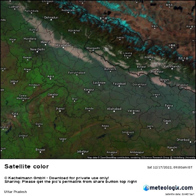 Dense fog over the foothills of Himalayas in the Uttar Pradesh during the morning hours of 17 December[/caption] Cold wave Despite the dull phase of the winter so far, cold wave conditions have started showing up in parts of Rajasthan, Haryana and Punjab in the second half of the current week. Temperatures dipped to freezing zero in Fatehpur Shekhawati region of North Rajasthan on 16 December. As the dry weather conditions are prevailing along with the cold weather conditions, minimum temperatures are expected to stay below normal across the next week which will lead on an expansion of coldwave in more parts of North India. Temperatures might even fall to minus in parts of Punjab and North Rajasthan, whereas Delhi and parts of Uttar Pradesh to experience minimum temperatures around 5°C as coldwave tighten grip in the upcoming weeks. [caption id=“attachment_11846101” align=“alignnone” width=“640”]
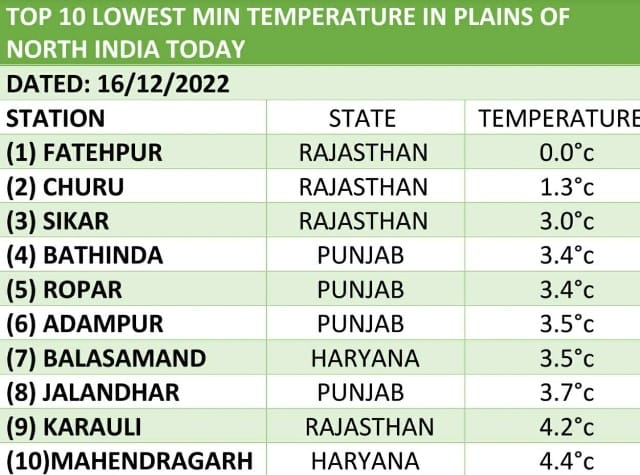 Top 10 lowest minimum temperature in the plains of north India on 16 December[/caption] Coldwave conditions are declared when the actual minimum temperature is 4°C or below. Also, if the departure from normal is -4.5°C when actual minimum temperature in the plains is below 10°C, in case of Severe coldwave the departure should be below normal by -6.5°C. The current status of winters indicate nights are expected to turn very cold in the remaining days of December but the region will escape the typical cold days since the maximum temperatures will continue to disappoint. January’s second half might do the justice with wet weather and cold days if parameters fit right. The author, better known as the Rohtak Weatherman, interprets and explains complex weather patterns. His impact-based forecasts @navdeepdahiya55 are very popular in north India. Read all the
Latest News ,
Trending News ,
Cricket News ,
Bollywood News , India News and
Entertainment News here. Follow us on
Facebook,
Twitter and
Instagram.
Top 10 lowest minimum temperature in the plains of north India on 16 December[/caption] Coldwave conditions are declared when the actual minimum temperature is 4°C or below. Also, if the departure from normal is -4.5°C when actual minimum temperature in the plains is below 10°C, in case of Severe coldwave the departure should be below normal by -6.5°C. The current status of winters indicate nights are expected to turn very cold in the remaining days of December but the region will escape the typical cold days since the maximum temperatures will continue to disappoint. January’s second half might do the justice with wet weather and cold days if parameters fit right. The author, better known as the Rohtak Weatherman, interprets and explains complex weather patterns. His impact-based forecasts @navdeepdahiya55 are very popular in north India. Read all the
Latest News ,
Trending News ,
Cricket News ,
Bollywood News , India News and
Entertainment News here. Follow us on
Facebook,
Twitter and
Instagram.
The absence of cloudy and wet weather is resulting in a high diurnal range over the low to mid-Himalayan ranges
Advertisement
End of Article

 "Russian drones over Poland: Trump’s tepid reaction a wake-up call for Nato?")
 "As Russia pushes east, Ukraine faces mounting pressure to defend its heartland")
 "Why Mossad was not on board with Israel’s strike on Hamas in Qatar")
 "Turkey: Erdogan's police arrest opposition mayor Hasan Mutlu, dozens officials in corruption probe")


