
 "The Weather Report: Sweltering heat brings India back to harsh reality of summer as dry week looms")
The phase of wet and cool weather lasted longer this time. There have been no significant summer spells this year except a brief spell of a heatwave in April. Pre-monsoon rains are dominating in India under the influence of frequent western disturbances over north India, and persistent lower-level wind discontinuity in central and southern parts of the country, the moisture and the cooling in the atmosphere lasted longer so that the temperatures in the first week of May have reached close to the record lows. [caption id=“attachment_12566912” align=“alignnone” width=“300”] Record low seasonal temperature anomaly in India till 7 May, 2023[/caption] Good rains and hailstorms continue to impact the western Himalayas over the weekend, precipitation was observed in Jammu Kashmir, Himachal Pradesh ending 8:30 AM on Sunday morning: Jammu and Kashmir Jammu AP – 27.6mm Bhaderwah – 25.2mm Banihal – 23.3mm Jammu city – 19.7mm Katra – 16.2mm Pahalgam – 14.4mm Qazi Gund – 14.0mm Srinagar – 6.8mm Himachal Pradesh Snowfall Keylong – 3.2cm Rainfall Bharmour – 30.0mm Palampur – 16.8mm Dharamshala – 13.1mm Kangra – 12.1mm Chamba – 11.5mm Mandi – 9.4mm Bhuntar – 5.5mm The fair amount of rainfall in the North, Central and Southern parts of the country is keeping the pre-monsoon anomaly on the highly positive side. In the period of 1 March to 7 May the country as a whole received 105.7mm against the normal of 81.0mm, departure from normal stands at +30 per cent. Subdivision-wise seasonal rainfall in the period of 1 March to 7 May: • Southern Peninsula: Actual 120.8mm against the average of 62.4mm, +94% departure from normal. • East and North East India**: Actual 156.9mm against the average of 221.3mm, -29 per cent departure from normal. • North West India: Actual 105.6mm against the average of 86.7mm, +22 per cent departure from normal. • Central India: Actual 72.6mm against the average of 20.1mm, +261 per cent departure from normal.** [caption id=“attachment_12568942” align=“alignnone” width=“214”]
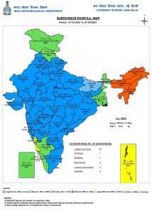 Normal to excessive seasonal rainfall across India except states of north east India and coastal Karnataka[/caption] Current synoptic weather features influencing weather in India as on 7 May, 2023: • The Western Disturbance is now seen as a cyclonic circulation over north Pakistan and a neighbourhood extending up to 3.1 km above mean sea level with the trough aloft with its axis at 5.8 km above mean sea level roughly along Long. 70°E to the north of Lat. 30°N. • The cyclonic circulation over northeast Rajasthan and the neighbourhood persists and is now seen at 0.9 km above mean sea level. • The trough roughly along Long. 88°E to the north of Lat. 23°N at 0.9 km above mean sea level has become less marked. • The cyclonic circulation over the Southwest Bay of Bengal off the north Tamilnadu coast between 1.5 km and 5.8 km above mean sea level persists and now tilts southwestwards with height. • The cyclonic circulation over the southeast Bay of Bengal and its neighbourhood now lies over the southeast Bay of Bengal & adjoining the south Andaman Sea and extends up to the middle tropospheric level. Under its influence, a low-pressure area is likely to form over the same region on 8th May. It is likely to intensify into a depression over the Southeast Bay of Bengal and the adjoining South Andaman Sea around 9 May. Thereafter, it is likely to intensify into a cyclonic storm while moving nearly northwards towards the central Bay of Bengal and adjoining the north Andaman Sea. [caption id=“attachment_12569032” align=“alignnone” width=“300”]
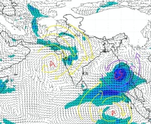 Weather chart analysis: Cyclone Mocha in Bay of Bengal, Anti-cyclonic circulation over Bay of bengal to push dry winds towards India during next week[/caption] Bay of Bengal brewing its own “Mocha” A cyclonic circulation has emerged over the south-east Bay of Bengal and deep convection is observed over the Indian Ocean towards the bay indicating the system is likely to intensify into a deep depression within the next 48 hours, by late 9th or early 10th May It is expected to intensify into a cyclonic storm, to be named “Mocha” however to be pronounced as “Mokha”, the name is given by Yemen. The jet streams will dominate the track of the Cyclone which will ensure that Mocha will remain away from the east coast of India due to upper-level winds creating a strong push and may drift the system towards Myanmar, though the landfall is still a week away the complex atmospheric conditions may lead to change in the path of the Cyclone, the uncertainty with landfall location will remain at least till early next week. Summers, not any more on the back seat, will be on your doorstep next week The abnormally cool and wet period is about to end, and summers to strike back next week across India as anti-cyclonic circulation is seen developing in the Arabian Sea along with cyclone Mocha in the bay to pull all moisture from inland. Weather conditions over India is expected to be mainly dry for the next 7 days, along with hot dust raising westerly winds from Thar desert, In the period of 9 to 14 May maximum temperature is forecasted to reach up to 45-46°c in parts of Rajasthan, Gujarat, MadhyaPradesh, Maharashtra, Telangana, AndhraPradesh and Odisha while it will be recorded in the range of 42 to 44°c in Delhi, Haryana, Punjab, Uttar Pradesh, Chhattisgarh and Jharkhand. The long-delayed seasonal heatwave is expected in India as scorching summers make a comeback! Cyclone Mocha’s impact on monsoon’s progression The cyclone will strengthen the cross-equatorial monsoon winds, this may lead to a timely onset of monsoon in southern Andaman & Nicobar island. However, monsoon winds may weaken around the 18 May which could stall its progress towards the Indian mainland, sometimes after weakened winds takes at least two weeks for the cross-equatorial winds to revive, the initial meteorological analysis indicates monsoon might arrive in Kerala with a slight delay. The author, better known as the Rohtak Weatherman, interprets and explains complex weather patterns. His impact-based forecasts @navdeepdahiya55 are very popular in north India. Read all the Latest News , Trending News , Cricket News , Bollywood News , India News and Entertainment News here. Follow us on
Facebook,
Twitter and
Instagram.
Weather chart analysis: Cyclone Mocha in Bay of Bengal, Anti-cyclonic circulation over Bay of bengal to push dry winds towards India during next week[/caption] Bay of Bengal brewing its own “Mocha” A cyclonic circulation has emerged over the south-east Bay of Bengal and deep convection is observed over the Indian Ocean towards the bay indicating the system is likely to intensify into a deep depression within the next 48 hours, by late 9th or early 10th May It is expected to intensify into a cyclonic storm, to be named “Mocha” however to be pronounced as “Mokha”, the name is given by Yemen. The jet streams will dominate the track of the Cyclone which will ensure that Mocha will remain away from the east coast of India due to upper-level winds creating a strong push and may drift the system towards Myanmar, though the landfall is still a week away the complex atmospheric conditions may lead to change in the path of the Cyclone, the uncertainty with landfall location will remain at least till early next week. Summers, not any more on the back seat, will be on your doorstep next week The abnormally cool and wet period is about to end, and summers to strike back next week across India as anti-cyclonic circulation is seen developing in the Arabian Sea along with cyclone Mocha in the bay to pull all moisture from inland. Weather conditions over India is expected to be mainly dry for the next 7 days, along with hot dust raising westerly winds from Thar desert, In the period of 9 to 14 May maximum temperature is forecasted to reach up to 45-46°c in parts of Rajasthan, Gujarat, MadhyaPradesh, Maharashtra, Telangana, AndhraPradesh and Odisha while it will be recorded in the range of 42 to 44°c in Delhi, Haryana, Punjab, Uttar Pradesh, Chhattisgarh and Jharkhand. The long-delayed seasonal heatwave is expected in India as scorching summers make a comeback! Cyclone Mocha’s impact on monsoon’s progression The cyclone will strengthen the cross-equatorial monsoon winds, this may lead to a timely onset of monsoon in southern Andaman & Nicobar island. However, monsoon winds may weaken around the 18 May which could stall its progress towards the Indian mainland, sometimes after weakened winds takes at least two weeks for the cross-equatorial winds to revive, the initial meteorological analysis indicates monsoon might arrive in Kerala with a slight delay. The author, better known as the Rohtak Weatherman, interprets and explains complex weather patterns. His impact-based forecasts @navdeepdahiya55 are very popular in north India. Read all the Latest News , Trending News , Cricket News , Bollywood News , India News and Entertainment News here. Follow us on
Facebook,
Twitter and
Instagram.
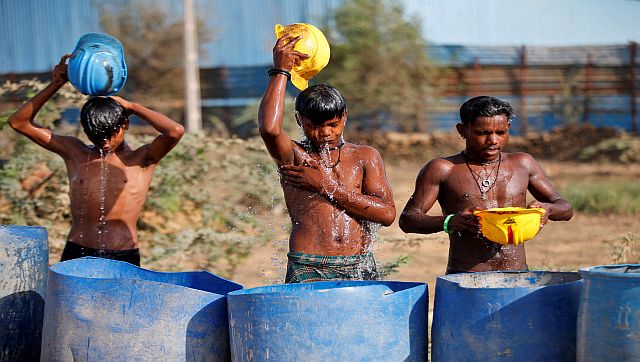
The abnormally cool and wet period is over and summers are back across India as anti-cyclonic circulation is seen developing in the Arabian Sea along with cyclone Mocha in the bay to pull all moisture from inland
Advertisement
End of Article

 "Russian drones over Poland: Trump’s tepid reaction a wake-up call for Nato?")
 "As Russia pushes east, Ukraine faces mounting pressure to defend its heartland")
 "Why Mossad was not on board with Israel’s strike on Hamas in Qatar")
 "Turkey: Erdogan's police arrest opposition mayor Hasan Mutlu, dozens officials in corruption probe")


