
 "The Weather Report | North India shivers in severe cold, south expects rains")
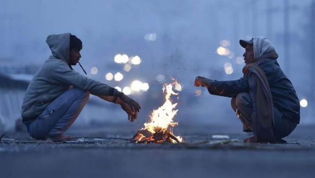
The much-awaited winters have finally arrived in India as temperatures have plummeted to the season’s lowest in many cities and states in the past week. The prolonged spell of warm December is not anymore dominating as the dense fog has finally settled in the plains of North India and day temperatures had registered a quick fall in the past couple of days. Dense to very dense fog has engulfed the states of Punjab, Haryana, Delhi NCR, Uttar Pradesh and Northern parts of Rajasthan since 17 December and continues to affect the region till 24 December with very low visibility, impacting operational flights, road and rail traffic. [caption id=“attachment_11875091” align=“alignnone” width=“640”] Satellite visuals show dense fog in Punjab, Haryana, North Rajasthan on Saturday morning[/caption] Key highlights on the weather and temperature during the week: • National Capital Delhi observed the coldest morning of the season on 23rd December by recording 5.3°c minimum temperature. • Balachaur in Punjab with -0.3°c recorded the first sub-zero minimum temperature in the plains of North India on Saturday morning 24 December. Top 10 lowest minimum temperatures in the plains of north India on 24th December • Barnala in Punjab with 15.7°c maximum temperature on 19th December became the first station in plains of North India to experience cold day conditions. Coldday is declared when the maximum temperature of the station is equal to or below 16°c while matching the condition single digit minimum temperature on the same day. • Gurdaspur in Punjab with 9.7°c on 22nd December recorded the first single digit maximum temperature of the season from plains of North India which was 10°c below normal. Severe cold day conditions in Punjab, Haryana due to the coverage of dense fog in the day time on 23 December • The cold winds from North India are even reaching up to Central and West India now, Mumbai experienced the coolest morning of the season so far by recording a minimum temperature of 16.0°c on 24th December. • Season’s lowest minimum temperature in various parts of Gujarat: Ahmedabad 10°c, Baroda 10.6°c, Surat 15.4°c, Bhavnagar 13°c, Dwarka 16°c, Porbandar 12.4°c. • The Himalayas are still awaiting the first proper snowfall of December but a streak of dry weather continues to prevail, despite that the minimum temperatures are falling across the states. Observed Sub-zero minimum temperature on 24th December: Ladakh and Kashmir Padum -19.4°c Drass -19.0°c Gulmarg -6.4°c Srinagar -5.4°c Himachal Pradesh Kukumsheri -7.9°c Sumdo -6.9°c Keylong -6.4°c Kalpa -4.6°c Uttarakhand Kedarnath -6.0°c Harsil - 4.1°c JankiChatti -2.2° Ranichauri - 0.2°c • The north east monsoon is in the last leg of the season, the southern peninsula was relatively dry across the past week with clear weather in most parts of Karnataka, Telangana, Goa, Andhra Pradesh, Tamil Nadu and Kerala. Along southern parts of the country most places in North, Central and East had a dry week leading to fall in overall seasonal rains this week to +20 per cent compared to +22 per cent during last Saturday. In the period of 1 October till 24 December, India as a whole received 140.2mm against the normal of 117.3mm, the departure from normal stands at +20 per cent. Subdivision wise seasonal rainfall figures • Southern Peninsula: Actual 292.4mm against the average of 270.3mm, +8 per cent departure from normal. • East & North East India: Actual 163.4mm against the average of 154.9mm, +5 per cent departure from normal. • North West India: Actual 80.6mm against the average of 46.1mm, +75 per cent departure from normal. • Central India: Actual 94.8mm against the average of 75.1mm, +26 per cent departure from normal. [caption id=“attachment_11875181” align=“alignnone” width=“640”]
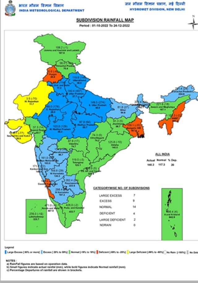 Seasonal rains in India in the period of 1 October till 24 December, 2022[/caption] Current synoptic features influencing weather in India as on 24 December: • The Depression over Southwest Bay of Bengal recurved gradually west-southwestwards with a speed of 13 kmph during past 06 hours and lay centered at 0830 hours IST of today, the 24 December over the same region near latitude 10.7°N and longitude 84.2°E about 400 km east-northeast of Trincomalee (Sri Lanka), 470 km east of Nagapattinam (Tamil Nadu) and 500 km east-southeast of Chennai (Tamil Nadu). It is likely to move further west-southwestwards and reach the Sri Lanka coast by the 25th morning. Thereafter, it would continue to move west-southwestwards across Sri Lanka and reach the Comorin Area and neighbourhood by 26th morning. • The Western Disturbance now seen as a trough in middle tropospheric westerlies with its axis at 5.8 km above mean sea level runs roughly along Longitude 72°E to the north of Latitude 32°N. All India Weather Forecast for Christmas and the next week till 31 December: North India: The peak winter phase has started in North India with a bang as cold days and coldwave conditions are prevailing in the region from the last couple of days. The strengthening of cold North West winds to ensure most parts of Jammu Kashmir, Himachal Pradesh, Uttarakhand, Punjab, Haryana, Delhi, Rajasthan, Uttar Pradesh to witness coldest morning of the season so far on the 25th December, the minimum temperatures are predicted to be as low as minus 1 to +3°c on Sunday morning, Dense fog in the morning hours is expected in various parts of Haryana, Punjab, Chandigarh and North Rajasthan which will result in cold day conditions on Christmas with expected maximum temperature in the range of 10 to 15°c. As the week progresses both minimum and maximum temperature to increase in presence of a weak Western Disturbance which could lead to partly cloudy weather in the plains, whereas cloudy weather and light snowfall is expected in Kashmir, Ladakh, Himachal Pradesh and Uttarakhand during 26th to 30th December and coldwave conditions will abate from most parts of Himalayas and Plains later in the week but day temperatures might register a fall during 28-31st December. Central and East India: The states in Central and eastern parts of the country will continue to experience dry weather across the upcoming week but the cold northerly winds to bring morning chill, most parts of Gujarat, Madhya Pradesh, Chhattisgarh, Bihar, Jharkhand to experience minimum temperatures in single digit, whereas minimum temperatures to dip below 15°c in most parts of Maharashtra, Odisha, West Bengal during Christmas and the week ahead, finally after the prolonged unseasonal warmth some winter is in store for central and east India in the last week of the year. Expected range of minimum and maximum temperature in the states of North, East and Central India till 31st December: • Punjab: -1 to 4°c, 10 to 16°c. • Haryana: 1 to 6°c, 12 to 17°c. • Delhi NCR: 3 to 7°c, 14 to 20°c. • Uttar Pradesh: 5 to 9°c, 17 to 23°c. • Rajasthan: -1 to 5°c, 15 to 24°c. • Chhattisgarh: 5 to 11°c, 24 to 30°c. • Bihar: 4 to 9°c, 23 to 27°c. • Jharkhand: 4 to 10°c, 25 to 31°c. • West Bengal: 8 to 13°c, 25 to 32°c. • Odisha: 6 to 13°c, 26 to 32°c. • Madhya Pradesh: 4 to 8°c, 24 to 28°c. • Gujarat: 7 to 15°c, 26 to 31°c. • Maharashtra: 7 to 16°c, 25 to 33°c. • North East India: 2 to 12°c, 18 to 27°c. [caption id=“attachment_11875301” align=“alignnone” width=“640”]
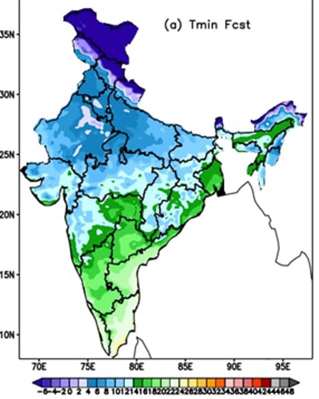 Prediction of the minimum temperature for India on the Christmas[/caption] South India: The depression in the south west bay of Bengal will move to brush the southern tip of the country in the upcoming week, under the influence of the weather system Chennai, parts of Tamil Nadu, Kerala to experience light to moderate rains on Christmas and across the next week. Karnataka, Telangana, Andhra Pradesh and Goa to experience dry weather across the next week along with the fall in night temperatures as winters finally set in the interiors of the peninsula. The current depression will be the last weather system for the ongoing North East Monsoon season, rains are all set to withdraw from Tamil Nadu and Kerala by the first of January, 2023 and dry weather to follow. Expected rainfall in South India till 31 December: Kerala: 30mm Tamil Nadu: 20mm Andhra Pradesh: 5mm Karnataka: 0mm Telangana: 0mm Goa: 0mm The author, better known as the Rohtak Weatherman, interprets and explains complex weather patterns. His impact-based forecasts @navdeepdahiya55 are very popular in north India. Read all the
Latest News ,
Trending News ,
Cricket News ,
Bollywood News , India News and
Entertainment News here. Follow us on
Facebook,
Twitter and
Instagram.
Prediction of the minimum temperature for India on the Christmas[/caption] South India: The depression in the south west bay of Bengal will move to brush the southern tip of the country in the upcoming week, under the influence of the weather system Chennai, parts of Tamil Nadu, Kerala to experience light to moderate rains on Christmas and across the next week. Karnataka, Telangana, Andhra Pradesh and Goa to experience dry weather across the next week along with the fall in night temperatures as winters finally set in the interiors of the peninsula. The current depression will be the last weather system for the ongoing North East Monsoon season, rains are all set to withdraw from Tamil Nadu and Kerala by the first of January, 2023 and dry weather to follow. Expected rainfall in South India till 31 December: Kerala: 30mm Tamil Nadu: 20mm Andhra Pradesh: 5mm Karnataka: 0mm Telangana: 0mm Goa: 0mm The author, better known as the Rohtak Weatherman, interprets and explains complex weather patterns. His impact-based forecasts @navdeepdahiya55 are very popular in north India. Read all the
Latest News ,
Trending News ,
Cricket News ,
Bollywood News , India News and
Entertainment News here. Follow us on
Facebook,
Twitter and
Instagram.
The cold winds from North India are even reaching up to Central and West India now
Advertisement
End of Article

 "Russian drones over Poland: Trump’s tepid reaction a wake-up call for Nato?")
 "As Russia pushes east, Ukraine faces mounting pressure to defend its heartland")
 "Why Mossad was not on board with Israel’s strike on Hamas in Qatar")
 "Turkey: Erdogan's police arrest opposition mayor Hasan Mutlu, dozens officials in corruption probe")


