
 "The Weather Report: North India set for winter; northeast monsoon to revive in Tamil Nadu, coastal Andhra Pradesh")
Winter has arrived in India, marked by the season’s inaugural active western disturbance impacting the hills and plains of North India on Thursday and Friday. The moderate to heavy snowfall has transformed the hill stations of Kashmir, Ladakh and Himachal Pradesh into a picturesque white landscape. Notably, Gulmarg in the Baramulla district of Kashmir recorded 10.4 cm of snowfall in the 24-hour period ending at 8:30 am on 10 November. Various other mountain peaks in the Himalayas of Kashmir, Ladakh and Himachal Pradesh reported significant snowfall ranging from 0.5 to 2 feet on 10 and 11 November, marking the season’s first substantial snowfall in feet. The Jammu division also experienced substantial rainfall, with the Bantalab station recording 42.0mm from thunderstorms. Weather systems played a pivotal role in dispersing the hazardous smog that had enveloped the region from 10 to 12 November, causing a “Severe” air quality index throughout the plains. Following the rainfall and improved wind speed, the air quality index temporarily improved to the “Moderate” category for two consecutive days before reverting to the “Very Poor” category on 13 November. Diwali signifies the onset of winter in North India, with Rithola at 8.7°C and Fatehpur at 9.7°C in Rajasthan becoming the first stations to report single-digit minimum temperatures in the plains this season. The temperature dropped further on Monday morning, with several cities experiencing their season’s lowest temperatures: Ludhiana recorded 8.8°C, Hisar 11.0°C, New Delhi 11.8°C, Chandigarh 12.3°C and Kanpur 12.6°C. As the snowfall took a pause, clear skies returned to the Himalayas, leading to a decline in minimum temperatures across Jammu and Kashmir, Himachal Pradesh and Ladakh on Monday morning. Padum -8.0°C Drass -6.8°C Leh -4.2°C Gulmarg -3.0°C Keylong -1.1°C Qazi Gund 0.3°C Srinagar 1.5°C Kalpa 2.4°C Banihal 3.2°C Manali 4.2°C Bhaderwah 4.2°C Bhuntar 5.4°C Sundernagar 7.5°C [caption id=“attachment_13384032” align=“alignnone” width=“640”] Below normal minimum and maximum temperature across north west India after the passage of the western disturbance[/caption] Rainfall was witnessed in various parts of South and Central India earlier in the week, but dry weather conditions have prevailed during the Diwali festivities, ensuring that the celebratory spirit remains undisturbed. The cumulative pan-India rainfall from 1 October to 12 November is reported at 67.3mm, as opposed to the normal of 90.1mm. This indicates a departure from the normal by -25%. Subdivision-wise seasonal rainfall figures up to 12 November, 2023, are as follows: • Southern Peninsula: Actual rainfall recorded is 123.6mm, contrasting with the average of 198.3mm, resulting in a departure from the normal of -38%. • East & North East India: The actual rainfall is 136.7mm, slightly surpassing the average of 135.7mm, resulting in a marginal departure from the normal of +1%. • North West India: The actual rainfall stands at 40.6mm, significantly exceeding the average of 26.3mm, resulting in a departure from the normal of +54%. • Central India: The actual rainfall is 25.8mm, notably lower than the average of 63.7mm, resulting in a departure from the normal of -59%. [caption id=“attachment_13384122” align=“alignnone” width=“640”]
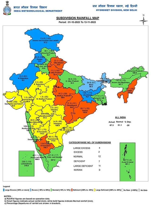 Seasonal rainfall over meteorological subdivisions of India till 13 November, 2023[/caption] Current synoptic weather features influencing weather in India as of 13 November, 2023: • The upper air cyclonic circulation over the South Andaman Sea, extending up to middle tropospheric levels and tilting southwestwards with height, persists. Under its influence, a Low-Pressure Area is likely to form over the Southeast Bay of Bengal in the next 24 hours. It is anticipated to move west-northwestward and intensify into a depression over the West Central Bay of Bengal around 16 November, 2023. • The upper air cyclonic circulation over the Southwest Bay of Bengal persists and now extends up to middle tropospheric levels. • The upper air cyclonic circulation over Southwest and adjoining West Central Arabian Sea, extending up to 1.5 km above mean sea level, has become less marked. • The trough in middle tropospheric westerlies at 5.8 km above mean sea level, running along Longitude 82°E to the north of Latitude 28°N, has moved away northeastwards. All-India weather forecast till 19 November, 2023: The upcoming week is expected to be dry across North and Central India as western disturbances will remain absent. Winter has set in, with temperatures falling to single digits. Until 19 November, minimum temperatures may drop to sub-zero levels in various hill stations of Kashmir, Ladakh, Himachal Pradesh and Uttarakhand. Temperatures could also plummet below 10°C in various other stations of Punjab, Haryana, Chandigarh, Delhi NCR, Rajasthan and Uttar Pradesh. As the falling trend continues in the north, parts of Central and East India are expected to join the sub-15°C club next week. Night temperatures will start falling in Bihar, Jharkhand, West Bengal, Odisha, Chhattisgarh, Madhya Pradesh, Gujarat, Maharashtra, Andhra Pradesh, and Telangana under the influence of dry and cold northwest winds. After a dry weekend, the northeast monsoon is set to revive over Tamil Nadu and coastal Andhra Pradesh this week, as moderate to heavy rains are expected to return with the strengthening easterlies. Bay of Bengal to host rare November cyclone? The upper air cyclonic circulation over the South Andaman Sea, extending up to middle tropospheric levels and tilting southwestwards with height, persists. Under its influence, a Low-Pressure Area is likely to form over the Southeast Bay of Bengal in the next 24 hours. It is expected to move west-northwestward and intensify into a depression over the West Central Bay of Bengal around November 16, 2023. There is a fair probability of it intensifying into a cyclonic storm by November 17 and crossing the coast of West Bengal or Bangladesh. The dynamics of the weather may evolve, but a strong and rare mid-November weather system is anticipated to develop in the Bay of Bengal. The writer, better known as the Rohtak Weatherman, interprets and explains complex weather patterns. His impact-based forecasts @navdeepdahiya55 are very popular in north India. Views expressed in the above piece are personal and solely that of the author. They do not necessarily reflect Firstpost_’s views._ Read all the
Latest News ,
Trending News ,
Cricket News ,
Bollywood News , India News and
Entertainment News here. Follow us on
Facebook,
Twitter and
Instagram.
Seasonal rainfall over meteorological subdivisions of India till 13 November, 2023[/caption] Current synoptic weather features influencing weather in India as of 13 November, 2023: • The upper air cyclonic circulation over the South Andaman Sea, extending up to middle tropospheric levels and tilting southwestwards with height, persists. Under its influence, a Low-Pressure Area is likely to form over the Southeast Bay of Bengal in the next 24 hours. It is anticipated to move west-northwestward and intensify into a depression over the West Central Bay of Bengal around 16 November, 2023. • The upper air cyclonic circulation over the Southwest Bay of Bengal persists and now extends up to middle tropospheric levels. • The upper air cyclonic circulation over Southwest and adjoining West Central Arabian Sea, extending up to 1.5 km above mean sea level, has become less marked. • The trough in middle tropospheric westerlies at 5.8 km above mean sea level, running along Longitude 82°E to the north of Latitude 28°N, has moved away northeastwards. All-India weather forecast till 19 November, 2023: The upcoming week is expected to be dry across North and Central India as western disturbances will remain absent. Winter has set in, with temperatures falling to single digits. Until 19 November, minimum temperatures may drop to sub-zero levels in various hill stations of Kashmir, Ladakh, Himachal Pradesh and Uttarakhand. Temperatures could also plummet below 10°C in various other stations of Punjab, Haryana, Chandigarh, Delhi NCR, Rajasthan and Uttar Pradesh. As the falling trend continues in the north, parts of Central and East India are expected to join the sub-15°C club next week. Night temperatures will start falling in Bihar, Jharkhand, West Bengal, Odisha, Chhattisgarh, Madhya Pradesh, Gujarat, Maharashtra, Andhra Pradesh, and Telangana under the influence of dry and cold northwest winds. After a dry weekend, the northeast monsoon is set to revive over Tamil Nadu and coastal Andhra Pradesh this week, as moderate to heavy rains are expected to return with the strengthening easterlies. Bay of Bengal to host rare November cyclone? The upper air cyclonic circulation over the South Andaman Sea, extending up to middle tropospheric levels and tilting southwestwards with height, persists. Under its influence, a Low-Pressure Area is likely to form over the Southeast Bay of Bengal in the next 24 hours. It is expected to move west-northwestward and intensify into a depression over the West Central Bay of Bengal around November 16, 2023. There is a fair probability of it intensifying into a cyclonic storm by November 17 and crossing the coast of West Bengal or Bangladesh. The dynamics of the weather may evolve, but a strong and rare mid-November weather system is anticipated to develop in the Bay of Bengal. The writer, better known as the Rohtak Weatherman, interprets and explains complex weather patterns. His impact-based forecasts @navdeepdahiya55 are very popular in north India. Views expressed in the above piece are personal and solely that of the author. They do not necessarily reflect Firstpost_’s views._ Read all the
Latest News ,
Trending News ,
Cricket News ,
Bollywood News , India News and
Entertainment News here. Follow us on
Facebook,
Twitter and
Instagram.
The dynamics of the weather may evolve, but a strong and rare mid-November weather system is anticipated to develop in the Bay of Bengal
Advertisement
End of Article

 "Russian drones over Poland: Trump’s tepid reaction a wake-up call for Nato?")
 "As Russia pushes east, Ukraine faces mounting pressure to defend its heartland")
 "Why Mossad was not on board with Israel’s strike on Hamas in Qatar")
 "Turkey: Erdogan's police arrest opposition mayor Hasan Mutlu, dozens officials in corruption probe")


