The twists related to monsoon onset in Kerala are over. Finally, the rainy season started in Kerala on 8 June, 2023 after a delay of nearly one week. The Indian Meteorological Department on the Thursday afternoon announced that the Southwest Monsoon has advanced into remaining parts of south Arabian Sea and some parts of central Arabian Sea, entire Lakshadweep area, most parts of Kerala, most parts of south Tamil Nadu, remaining parts of Comorin area, Gulf of Mannar and some more parts of southwest, central and northeast Bay of Bengal on 8 June, 2023. Thus, Southwest Monsoon has set in over Kerala against the normal date of 1 June. During the past 24 hours, clouding has increased over Southeast Arabian Sea with Outgoing Long wave Radiation(OLR) being <200 w/m2. The depth of westerlies over Southeast Arabian Sea extends upto mid tropospheric levels. The strength of Westerlies in the lower levels has increased to about 19 knots. Thus, there has been widespread rainfall over Kerala during the past 24 hours. Considering all the above satisfied conditions, Southwest Monsoon has set in over Kerala. Rainfall ending 8:30AM on 8th June in the major cities of Kerala: Kozhikode 74mm Punalur 59mm Kottayam 46mm Kozhikode AP 44mm Kochi 30mm Thrissur 26mm Trivandrum AP 21mm Mangalore AP 12mm Trivandrum 11m Karwar 9mm Honnavara 8mm The Northern Limit of Monsoon (NLM) now passes through lat. 13.5°N/ Long. 55°E, lat. 14.0°N/ Long. 60°E, lat. 13.5°N/ Long. 65°E, Lat.13°N/ Long. 70°E, Cannur, Kodaikanal, Adirampattinam, Lat. 12.0°N/ Long. 83.0°E, 16.0°N/88.0°E, 18.5°N/90.0°E, 22.0°N/93.0°E. [caption id=“attachment_12713032” align=“alignnone” width=“300”]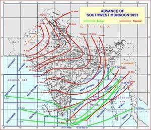 The Northern limit of monsoon passing through Kerala and Tamil Nadu on Thursday, 8 June[/caption] Conditions are favourable for further advance of Southwest monsoon into some more parts of central Arabian Sea, remaining parts of Kerala, some more parts of Tamil Nadu, some parts of Karnataka and some more parts of southwest, Central and northeast Bay of Bengal and some parts of northeastern states during next 48 hours. Why was the monsoon delayed? The monsoon has delayed in India as the Cyclone Biparjoy formed in the Arabian sea pulled out moisture from the ocean and weakened the monsoonal winds. The very severe cyclonic storm “Biparjoy” (pronounced as “Biporjoy”) over east central Arabian Sea moved nearly northwards with a speed of 5 kmph during past 6 hours and lay centered at 0830 hours IST of 8 June, 2023 over the same region near latitude 14.0°N and longitude 66.0°E, about 850 km west-southwest of Goa, 900 km southwest of Mumbai, 930 km south-southwest of Porbandar and 1220 km south of Karachi. It would intensify further gradually during the next 24 hours and move nearly north-northwestwards during the next three days, it is not expected to impact directly over any part of the country. [caption id=“attachment_12713092” align=“alignnone” width=“199”]
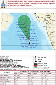 Expected track of Cyclone Biparjoy. Graphics courtesy IMD[/caption] More facts about Cyclone Biparjoy • Cyclone Biparjoy has rapidly intensified and intensified by 45 knots between 6 June 00UTC -7 June 00UTC. This is jointly the 2nd most intense rapid intensification by a north Indian Ocean cyclone having its genesis in June. • As per IMD, it has undergone rapid intensification and intensified by 30 knots from depression to severe cyclone in the mentioned period. • Cyclone Biparjoy, with a wind speed of 80 knots (as per JTWC) is now the 4th strongest cyclone in the north Indian Ocean, having its genesis in June. Also, this has surpassed the average maximum wind speed of a pre-monsoon season Arabian Sea cyclone for the period (2000-2019), The average is 75 knots. How does monsoon progress look ahead? The Arabian Sea branch will advance further in parts of South coastal Karnataka and some more parts of Tamil Nadu in next two days, along with that Bay of Bengal branch is expected to advance in parts of Meghalaya, Nagaland, Mizoram, Manipur at the same time. However, the further advancement of monsoon over the west coast of India till Mumbai latitude is highly dependent on the formation of offshore trough along the coast while the progress in interiors of east and central India is proportional to the formation of low-pressure area or depression in Bay of Bengal, both the conditions are not likely till 15 June hence further progress of monsoon will continue to be delayed. The author, better known as the Rohtak Weatherman, interprets and explains complex weather patterns. His impact-based forecasts @navdeepdahiya55 are very popular in north India. Read all the Latest News
, Trending News
, Cricket News
, Bollywood News
, India News
and Entertainment News
here. Follow us on
Facebook
,
Twitter
and
Instagram
.
Expected track of Cyclone Biparjoy. Graphics courtesy IMD[/caption] More facts about Cyclone Biparjoy • Cyclone Biparjoy has rapidly intensified and intensified by 45 knots between 6 June 00UTC -7 June 00UTC. This is jointly the 2nd most intense rapid intensification by a north Indian Ocean cyclone having its genesis in June. • As per IMD, it has undergone rapid intensification and intensified by 30 knots from depression to severe cyclone in the mentioned period. • Cyclone Biparjoy, with a wind speed of 80 knots (as per JTWC) is now the 4th strongest cyclone in the north Indian Ocean, having its genesis in June. Also, this has surpassed the average maximum wind speed of a pre-monsoon season Arabian Sea cyclone for the period (2000-2019), The average is 75 knots. How does monsoon progress look ahead? The Arabian Sea branch will advance further in parts of South coastal Karnataka and some more parts of Tamil Nadu in next two days, along with that Bay of Bengal branch is expected to advance in parts of Meghalaya, Nagaland, Mizoram, Manipur at the same time. However, the further advancement of monsoon over the west coast of India till Mumbai latitude is highly dependent on the formation of offshore trough along the coast while the progress in interiors of east and central India is proportional to the formation of low-pressure area or depression in Bay of Bengal, both the conditions are not likely till 15 June hence further progress of monsoon will continue to be delayed. The author, better known as the Rohtak Weatherman, interprets and explains complex weather patterns. His impact-based forecasts @navdeepdahiya55 are very popular in north India. Read all the Latest News
, Trending News
, Cricket News
, Bollywood News
, India News
and Entertainment News
here. Follow us on
Facebook
,
Twitter
and
Instagram
.
Monsoon makes a delayed date with Kerala but in time for North East India; Cyclone Biparjoy intensifies
Navdeep Dahiya
• June 9, 2023, 09:36:46 IST
The further advancement of monsoon over the west coast of India till Mumbai latitude is highly dependent on the formation of offshore trough along the coast
Advertisement
 "Monsoon makes a delayed date with Kerala but in time for North East India; Cyclone Biparjoy intensifies")
End of Article