 "Assam floods: Why Brahmaputra river basin management is the need of the hour")
Brahmaputra, the youngest among major rivers in the world, is the lifeline of Assam as well the North East. Innumerable folktales and songs depict the love and emotions the people of the region have for the river since ages. During Ashokasthami, people in the state believe it becomes holier than Ganges.
Since 1954 the state has withstood 13 devastating floods; on an average Assam receives three to four waves of flood every year between May to September. These floods occur due to overflow from downpour and high sediment of landslides. Deforestation and shifting cultivation adds to the woes. The flood discharge of the Brahmaputra river is the fourth-highest in the world. As for annual sediment transport, it reaches 500 million tons, and is the second-highest, next to the Yellow river in the People’s Republic of China.
The Indian subcontinent has seen people being displaced, becoming refugees because of Partition, but in Assam there are many who shall share their stories of being displaced by the mighty river because of its erosion. By now people have learnt to live with their plight, to be victims of flood. This year Assam has witnessed unprecedented floods, almost all 33 districts are affected by flood. State authorities have set up 366 relief camps across 20 districts, providing temporary shelter for more than 95,000 people. Roads, homes and buildings have been submerged by flood waters in most parts of the state.
Interestingly, traditional flood impacted districts — Dhemaji, North Lakhimpur, Sivsagar and Majuli — are comparatively less affected by the first wave of flood. In contrast, lower and middle Assam districts like Bongaigaon, Barpeta, Nalbari, Mangaldai and Sonitpur are worst affected this year. Although the state has received 62 per cent more than usual rainfall during March-May this year, the primary reason in these districts is the excessive water released by bordering Bhutan from its dam.
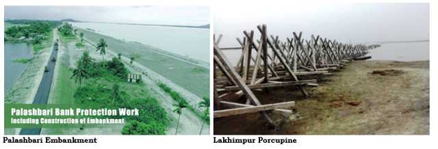
Broadly, there are two flood management measures — structural and non-structural. Any physical construction to control flood is called structural, e.g. embankment, porcupine, etc. Non-structural means anything not involving physical construction that uses knowledge, practice or agreement to reduce risks and impacts, including policies and laws, public awareness-raising, training and education. None of these traditional measures are yielding results.
Quick Reads
View All***
Also Read
Firstpost Podcast: Why Assam is prone to floods Explained: The Assam floods and the unfolding of a food and water crisis Explained: How Assam floods have endangered animals at Kaziranga National Park***
Although the state government has decided to dredge the river for erosion control, and flood control, there is no unanimity. According to the experts, dredged material can be utilised to fill geo tubes and to strengthen the existing embankments to Super Levee as developed in Japan. Interestingly, dredging of the Brahmaputra river was suggested way back in the 1950s and the 1960s by several experts, and accordingly, the then government decided to do so in 1966. In 1974, the first attempt was made at Chimna in Kamrup district, when a 7-km stretch was dredged with a width of 30m. Thereafter, a second attempt was made at Alikash to reduce erosion; although dredging prevented bank erosion, it failed to serve for long because the dredged portions were immediately filled up with silts. So far no scientific viability assessment has been conducted in the recent past.
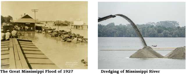
However, in far America, dredging of the Mississippi river has proved to be a success story of river basin management. The Americans have dredged the Mississippi river many times. The Mississippi river basin is now controlled and regulated by dams and other river engineering structures. Mississippi has witnessed many devastating floods, the worst being that of 1927.
Recently, dredging operations launched by the US Army Corps of Engineers (USACE) in 2020 have succeeded in lowering the first 172 miles of the Mississippi river ship channel to a minimum depth of 53-ft, so ships with a 50-ft draft can safely navigate the waterway up to the Port of South Louisiana.
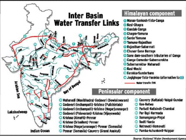
Networking of Rivers:
In Re: Networking of Rivers, (2012) 4 SCC 51, a three-judge Bench of the Supreme Court of India at para 79 of the judgement observed as follows:
“We not only express a pious hope of speedy implementation but also do hereby issue a mandamus to the Central and the state governments concerned to comply with the directions contained in this judgement effectively and expeditiously and without default. This is a matter of national benefit and progress. We see no reason why any state should lag behind in contributing its bit to bring the Inter-linking River Programme to a success, thus saving the people living in drought-prone zones from hunger and people living in flood-prone areas from the destruction caused by floods.”
As per the judgement, in principle, the state of Assam has consented to the concept. However, not much is known to us about the progress made in the river networking project.
Recently, the Ministry of Jalshakti has announced that under the National Perspective Plan (NPP), the National Water Development Agency (NWDA) has identified 30 links (16 under Peninsular Component and 14 under Himalayan Component) for preparation of Feasibility Reports (FRs). Detailed Project Reports (DPRs) of eight links have been completed.
When India is still contemplating, many countries have their inter-basin water transfer (IBT) projects functional in the last 50 years. Similarly, China is successfully transferring 48 km3 of water from the Yangtze river to the Yellow river to improve water availability in the arid plains of its North. If India wants to emerge as a superpower it has to take calculated risk of opting for ambitious projects and aggressively work towards its completion.
The writer is Advocate on Record, Supreme Court. Views expressed are personal.
Read all the Latest News
, Trending News
,
Cricket News
, Bollywood News
,
India News and Entertainment News here. Follow us on
Facebook
,
Twitter
and
Instagram
.