
 "Cyclonic storm Vardah likely to cross Andhra Pradesh-Tamil Nadu border on Monday")
Follow live updates of Cyclone Vardah here Vijayawada: Authorities on Sunday sounded an alert in Andhra Pradesh and adjoining Tamil Nadu as cyclonic storm ‘Vardah’ over the Bay of Bengal has turned into a “very severe” one. The storm is likely to cross north Tamil Nadu and south Andhra Pradesh coast by Monday afternoon, said Indian Meteorological Department on Sunday.
We’re expecting rainfall in Prakasam,Nellore,Chittoor,Kadapa distts & parts of Anantapur distt;Have made all necessary arrangements-MVS Babu pic.twitter.com/lsvOe3ahXJ
— ANI (@ANI) December 11, 2016
According to IMD, ‘Vardah’ over west central and adjoining south Bay of Bengal moved further westwards and lay centred at 530 hours over west central and adjoining southwest Bay of Bengal about 520 km east-southeast of Nellore, 490 km east-southeast of Machilipatnam and 480 km east-northeast of Chennai.
Control rooms opened in Vijayawada;Necessary personnel positioned in coastal mandals;5NDRF teams moved;Monitoring situation closely-MVS Babu pic.twitter.com/aPdZX2dyrG
— ANI (@ANI) December 11, 2016
“The storm is very likely to move nearly west-southeastwards and maintain its intensity till Sunday evening. Thereafter it will weaken gradually while moving towards south Andhra Pradesh coast and adjoining north Tamil Nadu coast,” the IMD said.
Cyclonic storm Vardah over west central & adjoining south Bay of Bengal moved further west-northwestwards during past 6hrs with 20kmph speed
— ANI (@ANI) December 11, 2016
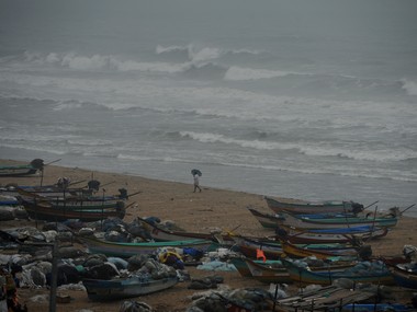
[caption id=“attachment_3150674” align=“alignleft” width=“380”] Representational image. AFP[/caption] The Met office has forecast light to moderate rains at many places with isolated heavy to very heavy falls over south Andhra coast and north coastal Tamil Nadu from Sunday evening for subsequent 36 hours. Light to moderate rains are likely to occur over north coastal Andhra.
Sea condition will be rough over South Andhra & TN coast;Fishermen advised not to venture into sea in region during next 2days-SBalachandran pic.twitter.com/Kt8mvzAU9K
— ANI (@ANI) December 11, 2016
Impact Shorts
More ShortsStrong winds with speed of 40-50 kmph are likely along the coast from Sunday. The speed may increase to 70-80 kmph at the time of landfall. Damage to thatched huts, power and communication lines, roads and crops is expected. As the sea will be rough, fishermen have been advised not to venture into the sea for next 48 hours. Authorities have hoisted third warning signal at all ports on Andhra coast.
Light moderate rain is expected at many places; Rainfall and strong winds expected to start from today evening: S Balachandran pic.twitter.com/f3vq9u2sqh
— ANI (@ANI) December 11, 2016
District administration in Krishna, Guntur, Prakasam and Nellore have been alerted to take all precautionary measures. Andhra Pradesh Chief Minister N. Chandrababu Naidu, who has cancelled his visit to the UAE and Kuwait, is monitoring the situation from the command and control centre in Vijayawada.
#CycloneVardah is expected to cross South Andhra, North TN, coastal region close to Chennai by Dec 12 afternoon: Regional Met dept director pic.twitter.com/Kbpy1PrTpf
— ANI (@ANI) December 11, 2016
Naidu deputed four senior IAS officers to four districts to take necessary steps to minimise the loss of lives and property. Two teams of National Disaster Response Force have reached Nellore district.

 "Charlie Kirk, shot dead in Utah, once said gun deaths are 'worth it' to save Second Amendment")
 "From governance to tourism, how Gen-Z protests have damaged Nepal")
 "Did Russia deliberately send drones into Poland’s airspace?")
 "Netanyahu ‘killed any hope’ for Israeli hostages: Qatar PM after Doha strike")


