 "Supreme Court clears Vantara elephant project, rejects PIL: Top 5 things to know")
 "Focus back to India-US trade deal: Trump’s negotiators landing in New Delhi tonight")
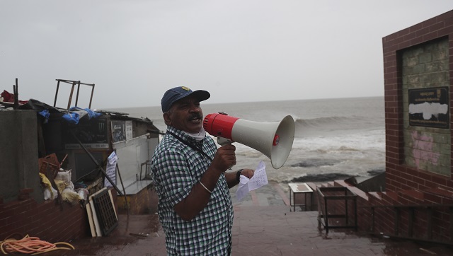
Cyclone Gulab Latest Updates: The landfall process of cyclone Gulab has started on Sunday evening and it may continue for about three hours, the India Meteorological Department (IMD) said. In the 21st century, only two tropical cyclones—Daye (2018) and Pyarr (2005)—have made landfall over the Indian east coast from the Bay of Bengal. Therefore, on Sunday, Cyclone Gulab will become the third such cyclone to make landfall in September. Barely four months after Yaas’ wreaked havoc in Odisha, the coastal state is bracing for another cyclone, Gulab, which is likely to make landfall on Sunday evening between Gopalpur and Kalingapatanam in Andhra Pradesh, the India Meteorological Department said. Cyclonic Storm ‘Gulab’ (pronounced as Gul-Aab) over northwest and adjoining west-central Bay of Bengal moved nearly westwards with a speed of 10 kmph during last 06 hours and lay centered at 0530 hrs IST today, over northwest and adjoining the west-central Bay of Bengal near Lat. 18.3°N and Long. 87.3°E, about 270 km east-southeast of Gopalpur (Odisha) & 330 km east of Kalingapatnam (Andhra Pradesh). It is likely to move nearly westwards and cross north Andhra Pradesh - south Odisha coasts between Kalingapatnam & Gopalpur around midnight of 26th September 2021. The deep depression over the Bay of Bengal intensified into cyclone ‘Gulab’ on Saturday and an ‘orange’ alert has been issued for north Andhra Pradesh and adjoining south Odisha coasts, it said. West Bengal, however, heaved a sigh of relief for now, as the weatherman said the developing cyclonic storm is expected to reach the region by 29 September, by when it is expected to have weakened considerably. The region, however, must watch out for the formation of a new low-pressure system near the coast of Myanmar, which, in all probability, will dump heavy rain in the state’s southern districts next week. Cyclone Gulab, as named by Pakistan, lay centered about 370 km east-southeast of Gopalpur in Odisha and 440 km east of Kalingapatnam in Andhra Pradesh, and it moved nearly westwards with a speed of 7 kmph in the last six hours, the IMD said. The system is likely to move nearly westwards and cross north Andhra Pradesh-South Odisha coasts between Kalingapatnam and Gopalpur around evening on 26 September, IMD Director-General Mrutunjay Mohapatra said. The Odisha government has already mobilised men and machinery and launched an evacuation drive in seven identified districts in the southern parts of the state. The maximum focus is on Ganjam and Gajapati, a senior official at the Special Relief Commissioner’s Office here said. Mohapatra said the wind speed of the weather system will vary between 75 kmph and 85 kmph, gusting up to 95 kmph. “Many low-lying areas will be inundated in the identified districts. Flash floods are feared in the hilly areas of Odisha’s southern region. Urban pockets in Ganjam and Puri could experience waterlogging due to heavy to very heavy and extremely heavy rainfall in parts,” he said. The Director of IMD Bhubaneswar, HR Biswas said, “Malkangiri, Nowrangpur, Koraput, Puri, Kalahandi and neighbouring districts will receive heavy to very heavy rainfall activity. Wind warnings have mainly been issued to Ganjam and Gajapati districts along the coast. The district collectors of Ganjam, Gajapati, Rayagada and Koraput have also taken precaution against possible landslides in view of the downpour and high-velocity winds, officials said. As many as 42 teams of the Odisha Disaster Rapid Action Force (ODRAF) and 24 squads of the National Disaster Response Force (NDRF), along with about 102 teams of fire brigade personnel, have been dispatched to the seven districts – Gajapati, Ganjam, Rayagada, Koraput, Malkangiri, Nabarangpur and Kandhamal, Special Relief Commissioner (SRC) PK Jena said. Ganjam is expected to be severely affected by the cyclonic storm, and 15 rescue teams have been deployed in that area alone, Jena said. Besides, 11 fire service units, six teams of the ODRAF and eight of the NDRF are on standby for emergency purposes, he said. Jena said the intensity of the cyclone will be similar to that of Titli’, which battered the state in 2018. “During the landfall, the wind speed could hover between 90 kmph and 100 kmph. Barring that period, the velocity on Sunday is expected to be limited to 70 kmph. Four-five districts will receive heavy rainfall. “Southern Odisha rivers such as Rushikulya, Nagabali and Vansadhara could swell due to extremely heavy rainfall,” the SRC said. Over the next three days, the sea condition will be rough to very rough and fishermen in Odisha, West Bengal and Andhra Pradesh have been asked to not venture out into the sea. Meanwhile, the IMD said Kolkata in West Bengal and its adjoining areas, which are still reeling under the impact of torrential rain that occurred earlier this week, should brace for heavy showers next Tuesday and Wednesday owing to the new weather system near the Myanmar coast. “The system is expected to move northwestwards and reach the West Bengal coast around September 29,” it said in a special bulletin. Under the influence of cyclone ‘Gulab’ and the developing weather system, rain and thundershower with lightning are very likely to occur at “many places” in south Bengal on Sunday and Monday, and “most places” on Tuesday and Wednesday, the weatherman added. With inputs from agencies

Cyclone Gulab Updates: Storm likely to weaken into deep depression during next six hrs, says IMD
Cyclone Gulab LIVE Updates: The landfall process of cyclone Gulab has started on Sunday evening and it may continue for about three hours, the India Meteorological Department (IMD) said.
 "Cyclone Gulab Updates: Storm likely to weaken into deep depression during next six hrs, says IMD")
Gulab likely to weaken into deep depression during next 6 hrs: IMD
The IMD has said that Cyclone Gulab is likely to weaken into deep depression during the next six hours, ANI reported.
#CycloneGulab is likely to weaken into deep depression during the next 6 hours: Indian Meteorological Department (IMD)
— ANI (@ANI) September 26, 2021
Cyclone crosses north Andra Pradesh and south Odisha, says IMD
Cyclone Gulab crossed north Andhra Pradesh and south Odisha coasts, about 20 km north of Kalingapatnam and lay centred at 8:30 pm today over north Andhra Pradesh: Indian Meteorological Department (IMD)
The Cyclonic Storm GULAB crossed north Andhra Pradesh and south Odisha coasts, about 20 km north of Kalingapatnam and lay centred at 20:30 hrs IST of 26th Sep 2021 over north Andhra Pradesh.
— India Meteorological Department (@Indiametdept) September 26, 2021
Landfall process to continue for next 2-3 hours: IMD
#CycloneGulab | The landfall process, which commenced at around 6 pm, will continue for the next 2-3 hours over north coastal Andhra Pradesh and adjoining South Coastal Odisha, says IMD pic.twitter.com/KdViZlTuiU
— ANI (@ANI) September 26, 2021
Two Andhra Pradesh fishermen killed in Gulab storm, one missing
Two fishermen from Srikakulam district of Andhra Pradesh lost their lives in the cyclonic storm Gulab in Bay of Bengal on Sunday evening while another still remained missing.
Three more fishermen reached the shore safely and called state Fisheries Minister S Appala Raju over phone from Akkupalli village and told him they were safe.
Visuals from Srikakulam in Andhra Pradesh
#WATCH | Srikakulam in Andhra Pradesh witnessed strong winds and heavy rainfall due to Cyclone Gulab (Earlier visuals)
— ANI (@ANI) September 26, 2021
As per IMD, the landfall process has commenced in coastal regions of Andhra Pradesh and Odisha pic.twitter.com/RKSLzv5cGs
The landfall process of cyclone Gulab has started on Sunday evening and it may continue for about three hours, the India Meteorological Department (IMD) said.
Source: PTI
Landfall process commences north coastal Andhra Pradesh, adjoining south coastal Odisha: IMD
the cloud bands have touched coastal regions and thus the landfall process has commenced over north coastal Andhra Pradesh and adjoining south coastal Odisha. System will cross coasts between Kalingapatnam & Gopalpur, about 25 km to north of Kalingapatnam during next 3 hours.
— India Meteorological Department (@Indiametdept) September 26, 2021
Following trains have been diverted/rescheduled due to Cyclone Gulab
Diversion/Reschedule of Trains due to Cyclone “GULAB” #GulabCyclone pic.twitter.com/UoA0xkppJG
— South Central Railway (@SCRailwayIndia) September 26, 2021
Naval ships, aircraft on standby for rescue ops
The Indian Navy said that it was closely monitoring the movement of Cyclone Gulab and kept naval ships and aircraft on standby for rescue and relief operations.
Source: PTI
Watersheds in South Odisha at high risk: Bhubaneswar Meteorological Department
High Risk likely over few watersheds over districts of South Odisha in next 24 hours.
— Meteorological Centre, Bhubaneswar (@mcbbsr) September 26, 2021
Surface runoff/ Inundation may occur at some fully saturated soils & low-lying areas over the area as depicted in map due to the expected rainfall of Cyclonic Storm “Gulab”. pic.twitter.com/YxdfVpm8fr
As of now, more than 5000 people have been shifted to safe shelters, tweeted the official page of DM and collecter, Ganjam, Odisha.
Team Ganjam has shifted more than 5000 people to safe shelters. More than 900 safe structures identified. 333 pregnant women shifted to hospital #CycloneGulab @CMO_Odisha @rdmodisha pic.twitter.com/gcM9DKtgKb
— Collector & District Magistrate, Ganjam (@Ganjam_Admin) September 26, 2021
LIVE visuals at Kalingapatnam
The IMD had earlier stated that the landfall process is expected to commence around 6 pm between Kalingapatnam and Gopalpur.
Early visuals near #Kalingapatnam
— Meteorological Centre, Bhubaneswar (@mcbbsr) September 26, 2021
Landfall process to commence from 6pm today#CycloneGulab pic.twitter.com/16OKDJtgQ9
Tweeting that Cyclone Gulab will cross between Kalingapatnam and Gopalpur by midnight of today, the IMD also mentioned that the landfall process will commence around 6 pm today.
Cyclonic storm GULAB centered at 1630 IST of 26th Sep. about 85 km east-northeast of Kalingapattnam and 95 km south of Goplapur. To cross between Kalingapatnam & Gopalpur as a cyclonic storm by midnight of today. Landfall process will commence around 1800 IST of today. pic.twitter.com/PQf15iDIuI
— India Meteorological Department (@Indiametdept) September 26, 2021
Member of Parliament from Andhra Pradesh, L Raghu Rama Krishna Raju, took to Twitter and urged the people living in north coastal districts of the state to be watchful.
In view of #CycloneGulab which is expected to hit tonight, I request people living in north coastal districts of Andhra Pradesh to be very careful. Praying for everyone’s well being.
— K Raghu Rama Krishna Raju (RRR) (@KRaghuRaju) September 26, 2021
September Cyclone in Bay of Bengal rare but not unexpected
According to a report in _ The Weather Channel, w_hile post-monsoon cyclones are common across the North Indian Ocean basin, Gulab’s formation even when the monsoon is still active across India is a rare occurence. It is only the third such cyclone in this time of the year in the entire century. This is rare because during September, the temperature across the Bay of Bengal is relatively low and the wind shear is not favourable for a low pressure area to progress into a cyclonic storm. However, experts say that it’s not unexpected!
“Bay of Bengal is a hotbed for cyclones. Typically, cyclones in the Bay form in the first or second week of October. But, given the shift in climate patterns, it is not surprising to see cyclones during late September,” says Dr Sridhar Balasubramanian, an Associate Professor at IIT Bombay, where he also holds an adjunct faculty position in the IDP Climate Studies Centre.
Cyclone Gulab Latest Update
PM Modi calls Andhra Pradesh CM, takes stock of cyclone action
Prime Minister Narendra Modi called on Andhra Pradesh chief minister YS Jagan Mohan Reddy to take stock of the Cyclone Gulab situation in the state. PM Modi tweeted
Spoke to Andhra Pradesh CM Shri @ysjagan and took stock of the situation arising in the wake of Cyclone Gulab. Assured all possible support from the Centre. I pray for everyone’s safety and well-being.
— Narendra Modi (@narendramodi) September 26, 2021
Cyclone Gulab Latest Update
PM Modi dials up Odisha CM to enquire about Cyclone preparedness
Prime Minister Narendra Modi called Odisha chief minister Naveen Patnaik for updates on the Cyclone Gulab situation. PM Modi tweeted:
Discussed the cyclone situation in parts of Odisha with CM @Naveen_Odisha Ji. The Centre assures all possible support in overcoming this adversity. Praying for the safety and well-being of everybody.
— Narendra Modi (@narendramodi) September 26, 2021
Following trains of the East Coast Railway have been cancelled due to Cyclone Gulab
.@RailMinIndia #ECoRupdate Train Alert !!!
— East Coast Railway (@EastCoastRail) September 26, 2021
In addition to previous Media Bulletin, the bellow mentioned trains will be cancelled, diverted, rescheduled in view of cyclone “Gulab”. 👇👇👇@DRMWaltairECoR @DRMKhurdaRoad @DRMSambalpur pic.twitter.com/QDwpWADs1E
Cyclone Gulab centres around 100 km east-southeast of Gopalpur
According to IMD’s hourly bulletin, Cyclone Gulab is centred near latitude 18.45°N and longitude 85.1°E, about 105 km east-northeast of Kalingapattnum and 100 km east-southeast of Gopalpur at 3:30 pm.
Cyclone Gulab Latest Update
Here’s a satellite view of Cyclone Gulab, as it hurtles towards Andhra-Odisha coast
New satellite view of Cyclone #Gulab near #Odisha, India #CycloneGulab #GulabCyclone pic.twitter.com/HdLVK6YqTr
— Zoom Earth (@zoom_earth) September 26, 2021
Cyclone Gulab Latest Update
Windspeed to range between 70 and 90 kmph during Cyclone Gulab
During the landfall, the wind speed could hover between 90 kmph and 100 kmph. Barring that period, the velocity on Sunday is expected to be limited to 70 kmph, the IMD said. According to the Beaufort Wind Scale, this is enough to uproot large trees and cause considerable structural damage.
Cyclone Gulab Latest Update
Telangana, Chattisgarh to witness heavy falls today
Telangana and a few places in north interior Odisha and Chhattisgarh will also witness heavy rainfall today, the India Meteorological Department said in its latest bulletin.
Cyclone Gulab Latest Update
NDRF deploys teams in Odisha ahead of Cyclone landfall
As many as 42 teams of the Odisha Disaster Rapid Action Force (ODRAF) and 24 squads of the National Disaster Response Force (NDRF), along with about 102 teams of fire brigade personnel, have been dispatched to the seven districts — Gajapati, Ganjam, Rayagada, Koraput, Malkangiri, Nabarangpur and Kandhamal, Special Relief Commissioner (SRC) P K Jena said.
Cyclone Gulab Latest Update
Indian Navy on standby for emergency situation
As the cyclonic storm ‘Gulab’ formed in the Bay of Bengal is expected to make landfall between north Andhra Pradesh and south Odisha coast by late Sunday evening, the Eastern Naval Command and Naval Officers-in-Charge Odisha area have carried out preparatory activities to combat the possible effects.
“The Indian Navy is closely monitoring the movement of the Cyclonic Storm and is in constant liaison with the state administrations for rendering assistance as required,” a release from the Ministry of Defence said.
Cyclone Gulab Latest Update
Rainfall lashes southern, coastal Odisha
Rainfall lashes Odisha’s southern and coastal regions as Cyclone Gulab is likely to make landfall between Gopalpur and Kalingapatanam in Andhra Pradesh around midnight, the India Meteorological Department said.
Cyclone Gulab Latest Update
Odisha towns in storm-prone districts prepare shelters, helplines ahead of cyclone landfall
The adminitsration in Odisha is preparing ahead of the cyclone’s landfall. Emergency helplines have been opened in Hinjlicut town in Ganjam district. In Berhampur, the municipal corporation has converted schools into emergency shelter to help people staying in Kutchha houses.
Cyclone #GULAB Emergency helpline number of Hinjilicut Municipality - 8480528957. @SRC_Odisha@Ganjam_Admin @DUDA_Ganjam @HUDDeptOdisha pic.twitter.com/6Qv20bj6jR
— Hinjilicut Municipal Council (@MC_Hinjilicut) September 26, 2021
Cyclone Gulab Latest Update
Odisha, Andhra Pradesh on Orange alert
An orange alert has been issued in Odisha and Andhra Pradesh ahead of cyclone ‘Gulab’, which is approaching the coastal states from the Bay of Bengal and is expected to make landfall on Sunday evening according to the India Meteorological Department.
Cyclone Gulab Latest Update
Cyclone Gulab likely to make landfall in evening
Cyclone Gulab is likely to cross Odisha and Andhra Pradesh coasts at midnight, the Indian Meteorological Department has predicted. Both states have been put on high alert. The cyclonic storm may make landfall between Srikakulam (AP) and Puri or Balasore in (Odhisa) this evening.

News18 SheShakti 2025: Voices of cinema, sport and music redefine nation-building
At News18 SheShakti 2025 Delhi, women from sports, cinema, and music discussed breaking barriers. Kriti Sanon and Sanya Malhotra focused on equity in cinema, Mira Erda and Ashalata Devi on sports challenges, and Kavita Krishnamurti stressed humility and perseverance for lasting success.
More Impact Shorts "Charlie Kirk, shot dead in Utah, once said gun deaths are 'worth it' to save Second Amendment")
 "From governance to tourism, how Gen-Z protests have damaged Nepal")
 "Did Russia deliberately send drones into Poland’s airspace?")
 "Netanyahu ‘killed any hope’ for Israeli hostages: Qatar PM after Doha strike")
 "Charlie Kirk, shot dead in Utah, once said gun deaths are 'worth it' to save Second Amendment")
 "From governance to tourism, how Gen-Z protests have damaged Nepal")
 "Did Russia deliberately send drones into Poland’s airspace?")
 "Netanyahu ‘killed any hope’ for Israeli hostages: Qatar PM after Doha strike")
Top Shows


