 "China diverts Brahmaputra to build world's longest tunnel: Beijing has long used the river to impact region's geopolitics")
As China prepares to
build a 1,000-kilometre-long tunnel
by diverting the Brahmaputra river towards the parched Xinjiang region, Beijing’s ambitious projects has potentially worrisome implications for India, which have again come to the fore. The proposed tunnel, which will be the world’s longest once completed, is expected to “turn Xinjiang into California”. It would drop down from the world’s highest plateau to provide water to an area which now includes only vast swathes of desert and dry grasslands. The move, which is likely to give China an upper hand in geopolitical relations in the region, will also have deep environmental implications for other nations that the Brahmaputra passes through. The project falls in line with a long-running
hydro-power tussle
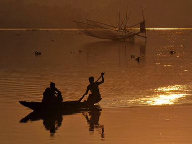
between two of the largest stakeholders, India and China, to harness the power of the mighty Brahmaputra. Brahmaputra’s strategic location [caption id=“attachment_607586” align=“alignleft” width=“380”] Representational image. AFP[/caption] The Himalayas give birth to multiple rivers, including the
Brahmaputra
, Mekong, Yangtze, Sutlej, Indus, Salween, and the Huang Ho. Apart from being one of the longest rivers in the world at 2,880 kilometres, the Brahmaputra is also a regional giant, with its tributaries extending through Tibet (where it is called Yarlung Tsangpo), the hills of North East India (as Siang and Brahmaputra), and the valleys of Bangladesh (as Jamuna), before emptying into the Bay of Bengal. In India, the path of the river has sculpted the natural and human landscape of two Northeastern states — Arunachal Pradesh and Assam, according to an essay in The Conversation
. In the past, Indian and Chinese governments have tried to undertake multiple hydro-power projects, including the
Lower Subansiri project
and the
Dibang Valley project
, the article says, and as many as 168 MoUs have been signed between the Arunachal Pradesh state government and
private and public dam-building companies
. China’s diversions to allow for construction of multiple hydroelectric dams are a stark reminder of the advantage Beijing holds over its downstream neighbours in Delhi and Dhaka. Impact on India China, especially in times of drought, keeps a tight handle on water supply from upstream areas. In 2016, Vietnam pleaded with Beijing to release water from the Yunnan dam into the Mekong river.
China complied, and water flowed
into Laos, Cambodia, Thailand, Myanmar and Vietnam. Even so, however, the drought damaged 1,40,000 hectares of rice in the Mekong Delta, while over 6,00,000 people faced water shortages. In India and Bangladesh, local communities are afraid of the environmental and socio-economic consequences of the mega-dams proposed by both
China
and
India
. The Conversation’s essay said that the size and scale of these proposed infrastructure developments on the river, and the wider region, is unprecedented in the history of Northeast India. Moreover, the monsoon also brings with it the threat of Chinese dams releasing water to ease pressure, often with little warning. In the past,
India has blamed sudden discharges from Chinese dams
as the cause of devastating flash floods in several parts of the country. Even earlier this year, heavy flooding was
witnessed in Assam,
from which some districts are yet to recover. Assam state government minister
Himanta Biswa Sarma
blamed heavy rainfall in China as the cause of the flooding that killed over 160 people and affected millions in the state. Refusal to share data [caption id=“attachment_4185399” align=“alignright” width=“380”]
Representational image. AFP[/caption] The Himalayas give birth to multiple rivers, including the
Brahmaputra
, Mekong, Yangtze, Sutlej, Indus, Salween, and the Huang Ho. Apart from being one of the longest rivers in the world at 2,880 kilometres, the Brahmaputra is also a regional giant, with its tributaries extending through Tibet (where it is called Yarlung Tsangpo), the hills of North East India (as Siang and Brahmaputra), and the valleys of Bangladesh (as Jamuna), before emptying into the Bay of Bengal. In India, the path of the river has sculpted the natural and human landscape of two Northeastern states — Arunachal Pradesh and Assam, according to an essay in The Conversation
. In the past, Indian and Chinese governments have tried to undertake multiple hydro-power projects, including the
Lower Subansiri project
and the
Dibang Valley project
, the article says, and as many as 168 MoUs have been signed between the Arunachal Pradesh state government and
private and public dam-building companies
. China’s diversions to allow for construction of multiple hydroelectric dams are a stark reminder of the advantage Beijing holds over its downstream neighbours in Delhi and Dhaka. Impact on India China, especially in times of drought, keeps a tight handle on water supply from upstream areas. In 2016, Vietnam pleaded with Beijing to release water from the Yunnan dam into the Mekong river.
China complied, and water flowed
into Laos, Cambodia, Thailand, Myanmar and Vietnam. Even so, however, the drought damaged 1,40,000 hectares of rice in the Mekong Delta, while over 6,00,000 people faced water shortages. In India and Bangladesh, local communities are afraid of the environmental and socio-economic consequences of the mega-dams proposed by both
China
and
India
. The Conversation’s essay said that the size and scale of these proposed infrastructure developments on the river, and the wider region, is unprecedented in the history of Northeast India. Moreover, the monsoon also brings with it the threat of Chinese dams releasing water to ease pressure, often with little warning. In the past,
India has blamed sudden discharges from Chinese dams
as the cause of devastating flash floods in several parts of the country. Even earlier this year, heavy flooding was
witnessed in Assam,
from which some districts are yet to recover. Assam state government minister
Himanta Biswa Sarma
blamed heavy rainfall in China as the cause of the flooding that killed over 160 people and affected millions in the state. Refusal to share data [caption id=“attachment_4185399” align=“alignright” width=“380”] File image of the Three Gorges Dam on the Yangtze River in Hubei province. Reuters[/caption] One solution devised to establish trust between the neighbours — and to avoid downstream flooding — was to regularly share hydrological data among the countries. This helps downstream India and Bangladesh forecast floods, and make necessary arrangements during the monsoon to tackle rise in water levels. The two countries signed
two pacts in 2008 and 2010
, facilitating India with data on water levels and rainfall twice a day, from 1 June to 15 October — the usual length of the monsoon season — at three hydrological stations in Tibet. Later in 2013, during former prime minister Manmohan Singh’s visit to Beijing, an MoU was signed where China agreed to share hydrological data with India from 15 May to 15 October annually. In August 2017, the external affairs ministry said
India has not received hydrological data
on Brahmaputra and Sutlej rivers from China this year despite existing agreements. China later cited technical reasons, saying a
data collection centre in the Tibet Autonomous Region was under renovation
. However, New Delhi does not seem to be convinced, especially since Bangladesh officials have also confirmed that China has shared hydrological data on Brahmaputra, The Economic Times
reported. In 2017, a swollen Brahmaputra wreaked havoc in Assam in four waves, displacing people of 29 districts, while in Punjab, over 10,000 acres of farm land were inundated by waters of the Sutlej. China tampering with the river’s flow Over the past decade, Beijing has undertaken several projects to divert the flow of the Brahmaputra and its tributaries, consistently ruffling diplomatic feathers in New Delhi and Dhaka. China’s 13th five-year plan proposed significant hydro-power expansion along rivers originating in the Tibetan plateau,
The Hindu
reported. Although the plan does not mention the rivers, the report said it is anticipated that the new dams are envisaged along the Yarlung Zangbo, Lancang (Mekong) and Nu (Salween). In 2016, during the construction of China’s most expensive hydroelectric project in Tibet,
China announced it will be blocking one of the Brahmaputra’s tributaries
, the Xiabuqu River. “The Lalho project on the Xiabuqu river in Xigaze involves an investment of $740 million,” an official said, sparking fears in India about possible repercussions the country will face once the project concludes in 2019. For the
1,000 kilometre-long Tibet-Xinjiang tunnel
, a “rehearsal project” to build a 600-kilometer long tunnel in Yunnan province was initiated in August.
File image of the Three Gorges Dam on the Yangtze River in Hubei province. Reuters[/caption] One solution devised to establish trust between the neighbours — and to avoid downstream flooding — was to regularly share hydrological data among the countries. This helps downstream India and Bangladesh forecast floods, and make necessary arrangements during the monsoon to tackle rise in water levels. The two countries signed
two pacts in 2008 and 2010
, facilitating India with data on water levels and rainfall twice a day, from 1 June to 15 October — the usual length of the monsoon season — at three hydrological stations in Tibet. Later in 2013, during former prime minister Manmohan Singh’s visit to Beijing, an MoU was signed where China agreed to share hydrological data with India from 15 May to 15 October annually. In August 2017, the external affairs ministry said
India has not received hydrological data
on Brahmaputra and Sutlej rivers from China this year despite existing agreements. China later cited technical reasons, saying a
data collection centre in the Tibet Autonomous Region was under renovation
. However, New Delhi does not seem to be convinced, especially since Bangladesh officials have also confirmed that China has shared hydrological data on Brahmaputra, The Economic Times
reported. In 2017, a swollen Brahmaputra wreaked havoc in Assam in four waves, displacing people of 29 districts, while in Punjab, over 10,000 acres of farm land were inundated by waters of the Sutlej. China tampering with the river’s flow Over the past decade, Beijing has undertaken several projects to divert the flow of the Brahmaputra and its tributaries, consistently ruffling diplomatic feathers in New Delhi and Dhaka. China’s 13th five-year plan proposed significant hydro-power expansion along rivers originating in the Tibetan plateau,
The Hindu
reported. Although the plan does not mention the rivers, the report said it is anticipated that the new dams are envisaged along the Yarlung Zangbo, Lancang (Mekong) and Nu (Salween). In 2016, during the construction of China’s most expensive hydroelectric project in Tibet,
China announced it will be blocking one of the Brahmaputra’s tributaries
, the Xiabuqu River. “The Lalho project on the Xiabuqu river in Xigaze involves an investment of $740 million,” an official said, sparking fears in India about possible repercussions the country will face once the project concludes in 2019. For the
1,000 kilometre-long Tibet-Xinjiang tunnel
, a “rehearsal project” to build a 600-kilometer long tunnel in Yunnan province was initiated in August.
“The water diversion project in central Yunnan is a demonstration project,” an official said. “It is to show we have the brains, muscle and tools to build super-long tunnels in hazardous terrains, and the cost does not break the bank,” he was quoted as saying in the South China Morning Post report.
Chinese engineers say the Tibetan plateau, often referred to as “the roof of the world”, stops the monsoon from reaching Xinjiang, leaving the Gobi desert in the north and the Taklimakan desert in the south unsuitable for human settlement. In recent decades, Chinese government departments, including the Ministry of Water Resources, have come up with engineering blueprints involving huge dams, pumps and tunnels. India has already flagged its concerns to Beijing about various dams being built by it on Brahmaputra river. Beijing has assured India and Bangladesh that its dams are not designed for storing water. The project’s enormous cost, engineering challenges, possible environmental impact and the likelihood of protests by neighbouring countries have meant that it never left the drawing board. But Zhang Chuanqing, a researcher at the Chinese Academy of Sciences’ Institute of Rock and Soil Mechanics in Wuhan, Hubei province, said China was now taking a quiet, step-by-step approach to bring it to life. With inputs from PTI