The weather conditions have been dramatically changing these days, India experienced fairly cold January and even it ended on a wet note for many parts of the country but February despite begin a winter month is been abnormally warm and might head to one of the hottest February country would have ever experienced since the record keeping begin by Indian meteorological department. Data itself is justifying the severity of the warmth, on 16th February Bhuj in Gujarat recorded 40.3°c maximum temperature, breaking its previous all time record of 39.0°c from 19th February, 2017, it is also the earliest above 40° temperature India ever experienced. The departure from normal for Bhuj is recorded as 10°c above normal, similarly various other stations in Gujarat, Rajasthan and Maharashtra have experienced day temperatures above normal by 6 to 9°c and nearing the all time highs. [caption id=“attachment_12168242” align=“alignnone” width=“622”]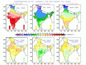 Temperature anomaly over India in the month of February so far, very warm conditions of North, west and central parts of the country[/caption] Maximum temperature on 16th February: Gujarat Rajkot: 39.3°c Deesa: 38.7°c Surendranagar: 38.6°c Keshod: 38.4°c Kandla: 38.1°c Mahuva: 37.8°c Ahmedabad: 37.5°c Vadodara: 37.4°c Surat: 36.8°c Rajasthan Barmer: 38.0°c Jalore: 36.8°c Jaisalmer: 36.6°c Mumbai and Konkan region Ratnagiri: 37.0°c Mumbai: 37.5°c Alibaug: 38.0°c NaviMumbai & Mira: 38.6°c Thane & Panvel: 39.0°c Dombivli & Badlapur: 39.2°c Devgad: 39.3°c Kalyan & Manor: 39.4°c If one thinks they can escape the heat in the Himalayas, hills stations are warm on their standards too, Shimla recorded 21.7°c Maximum temperature , which is massively above normal by 10°c on 16th February, Fell just 0.9° short from its all time record , this is the 4th highest temperature recorded at queen of hills during the month of February Previous highest: 22.6°C on 20th February 2006 21.8°C on 22nd February 2006 21.8°C on 5th February 2017. So, what is leading to an unprecedented spell of heat in various parts of the country in the month of February? 1. Deficiency of rainfall on a pan-India level Winter in India is highly dependent on frequency of western disturbance (WD) travelling to Himalayas and plains of the country. They bring snowfall over the hills and rainfall activities in plains leading to overall cooling and due to wet weather temperatures normally remain under control. For January this year the frequency of WDs passing over the Himalayas was nearly normal but they were mainly weak to moderate in strength, a strong WD also hit both hills and plains towards the end of January but dry weather is observed ever since, all the weak WDs are now restricted to Himalayas and plains of North, Central and East India have been fairly dry in the past 20 days. The longevity of the dry period is leading to higher temperatures in the region. In the period of 1st January till 16th February, the country as a whole recorded a total of 19.6mm rainfall against the normal of 29.1mm, the departure from normal stands at -33%. Subdivision wise seasonal rainfall in the period of 1st January till 16th February, 2023: • Southern Peninsula: Actual 6.1mm against the average of 12.3mm, -51% departure from normal. • East & North East India: Actual 9.5mm against the average of 31.1mm, -70% departure from normal. • North West India: Actual 52.9mm against the average of 57.5mm, -8% departure from normal. • Central India: Actual 1.9mm against the average of 12.1mm, -84% departure from normal. [caption id=“attachment_12168272” align=“alignnone” width=“372”]
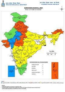 Seasonal rainfall over the country till 16th February has been deficient[/caption] 2. Strong anti cyclonic circulation over Gujarat Anti-cyclonic circulations are part of Indian climatology as they are formed from time to time when the season changes. On a normal note, an anti-cyclonic circulation forms up over west India around mid-April due to which spring transit into summer, but this year the first instance of anti-cyclone circulation was observed over India in early February and has strengthened further in mid February, this is the strongest and earliest high pressure development over the subcontinent ever. Technically, anti-cyclonic circulation is an area of sinking air that results in development of high pressure over a large geographical area; the area of high pressure experiences a small pressure gradient, the atmospheric pressure and air does not change rapidly and winds become gentle in nature. As the air starts sinking, it warms up, leading to warm and dry weather. In the Northern Hemisphere including India, winds in anti-cyclonic circulation rotate in clockwise direction. In layman’s terms, the building up of a high-pressure area during the month of February resulted in dry weather across the north and central India from the last 20 days. As winds were blowing from the middle east and Thar desert of Rajasthan, it is supposed to be moisture-free and hot. Humidity levels went way below 20 percent in peak afternoon hours along with exceptional rise in maximum temperature across India. [caption id=“attachment_12168282” align=“alignnone” width=“436”]
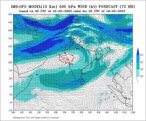 Anticyclonic circulation to intensify over Gujarat by 18th February, Clockwise wind movement in the charts over the Indian Subcontinent[/caption] What is in store for the weekend and early next week? The anti cyclonic circulation is by far holding strong over the sub continent, the synoptic feature looks irreplaceable for the coming 10 days, this will push entire country into a heat dome like situation where the warm winds will remain trapped and both maximum and minimum temperature are likely to increase further by 2-3°c during 17 to 22nd February, parts of Rajasthan, Gujarat, Maharashtra, Madhya Pradesh, Telangana, Chhattisgarh, Odisha, Andhra Pradesh should be targeting maximum temperatures of 40°c or higher at a few stations with above 37°c for most stations in general. Various parts of Punjab, Haryana, Delhi NCR, Uttar Pradesh, Bihar, Jharkhand are bound to experience maximum temperature in the range of 31 to 36°c with peak heat on 20th and 21st February. The maximum temperature anomaly is likely to be a whopping 6 to 12°c above normal at most stations in the country, and must be the highest in predictions ever. As per the forecasting models more or less there seems to be no significant relief from the warmer temperatures at least till month end, February 2023 might end on a historical warm note for the country, also many all time high records might tumble as the spring breaker heat is ahead in India, the sudden entry of summer will surprise many specially the farmers as wheat crop is still at a pre-mature stage and sudden warming will lead to unexpected ripening of the crop, production shortage loom large for the second year in a row. The author, better known as the Rohtak Weatherman, interprets and explains complex weather patterns. His impact-based forecasts @navdeepdahiya55 are very popular in north India. Read all the Latest News
, Trending News
,
Cricket News
, Bollywood News
, India News
and Entertainment News
here. Follow us on
Facebook
,
Twitter
and
Instagram
.
Anticyclonic circulation to intensify over Gujarat by 18th February, Clockwise wind movement in the charts over the Indian Subcontinent[/caption] What is in store for the weekend and early next week? The anti cyclonic circulation is by far holding strong over the sub continent, the synoptic feature looks irreplaceable for the coming 10 days, this will push entire country into a heat dome like situation where the warm winds will remain trapped and both maximum and minimum temperature are likely to increase further by 2-3°c during 17 to 22nd February, parts of Rajasthan, Gujarat, Maharashtra, Madhya Pradesh, Telangana, Chhattisgarh, Odisha, Andhra Pradesh should be targeting maximum temperatures of 40°c or higher at a few stations with above 37°c for most stations in general. Various parts of Punjab, Haryana, Delhi NCR, Uttar Pradesh, Bihar, Jharkhand are bound to experience maximum temperature in the range of 31 to 36°c with peak heat on 20th and 21st February. The maximum temperature anomaly is likely to be a whopping 6 to 12°c above normal at most stations in the country, and must be the highest in predictions ever. As per the forecasting models more or less there seems to be no significant relief from the warmer temperatures at least till month end, February 2023 might end on a historical warm note for the country, also many all time high records might tumble as the spring breaker heat is ahead in India, the sudden entry of summer will surprise many specially the farmers as wheat crop is still at a pre-mature stage and sudden warming will lead to unexpected ripening of the crop, production shortage loom large for the second year in a row. The author, better known as the Rohtak Weatherman, interprets and explains complex weather patterns. His impact-based forecasts @navdeepdahiya55 are very popular in north India. Read all the Latest News
, Trending News
,
Cricket News
, Bollywood News
, India News
and Entertainment News
here. Follow us on
Facebook
,
Twitter
and
Instagram
.
The Heat is On, Already: 40°c temperatures in February foretell a hard, long summer
Navdeep Dahiya
• February 17, 2023, 13:50:34 IST
The maximum temperature anomaly is likely to be a whopping 6 to 12°c above normal at most stations in the country, and can be the highest in predictions ever
Advertisement
 "The Heat is On, Already: 40°c temperatures in February foretell a hard, long summer")
End of Article