
 "Explained: Why tornadoes are so hard to forecast")
As a deadly tornado headed toward Rolling Fork, Mississippi, on 24 March, 2023, forecasters
saw the storm developing on radar and issued a
rare “tornado emergency” warning. NOAA’s (National Oceanic And Atmospheric Administration)
Weather Prediction and
Storm Prediction centres had been warning for several days about the risk of severe weather in the region. But while forecasters can see the signs of potential tornadoes in advance, forecasting when and where tornadoes will form is still extremely difficult. We asked
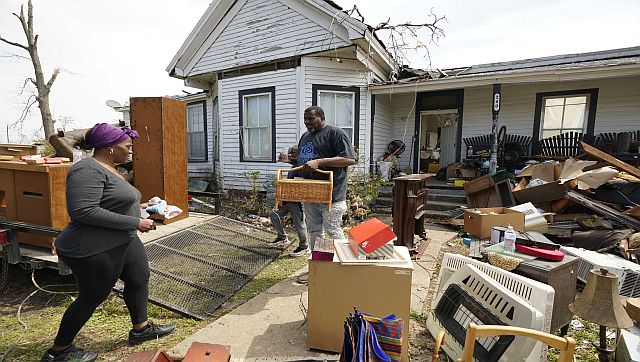
Chris Nowotarski, an atmospheric scientist who works on severe thunderstorm computer modelling, to explain why — and how forecast technology is improving. Why are tornadoes still so difficult to forecast? Meteorologists have gotten a lot better at forecasting the conditions that make tornadoes more likely. But predicting exactly which thunderstorms will produce a tornado and when is harder, and that’s where a lot of severe weather research is focused today. Often, you’ll have a line of thunderstorms in an environment that looks favourable for tornadoes, and one storm might produce a tornado but the others don’t. The differences between them could be due to small differences in meteorological variables, such as temperature. Even changes in the land surface conditions — fields, forested regions or urban environments — could affect whether a tornado forms. [caption id=“attachment_12369902” align=“alignnone” width=“640”] The underside frame of a mobile home was bent by the tornado Friday night, and was hurled into a Silver City, Mississippi. AP[/caption] These small changes in the storm environment can have large impacts on the processes within storms that can make or break a tornado. One of the strongest predictors of whether a thunderstorm produces a tornado relates to
vertical wind shear, which is how the wind changes direction or speed with height in the atmosphere. How wind shear interacts with rain-cooled air within storms, which we call “outflow,” and how much precipitation evaporates can influence whether a tornado forms. If you’ve ever been in a thunderstorm, you know that right before it starts to rain, you often get a gust of cold air surging out from the storm. The characteristics of that cold air outflow are important to whether a tornado can form, because tornadoes typically form in that cooler portion of the storm. How far in advance can you know if a tornado is likely to be large and powerful? It’s complicated. Radar is still our biggest tool for determining when to issue a
tornado warning — meaning a tornado is imminent in the area and people should seek shelter. The vast majority of violent tornadoes form from
supercells, thunderstorms with a deep rotating updraft, called a “mesocyclone.” Vertical wind shear can enable the midlevels of the storm to rotate, and upward suction from this mesocyclone can intensify the rotation within the storm’s outflow into a tornado. If you have a supercell and it has strong rotation above the ground, that’s often a precursor to a tornado. Some research suggests that
a wider mesocyclone is more likely to create a stronger, longer-lasting tornado than other storms. Forecasters also look at the storm’s environmental conditions — temperature, humidity and wind shear. Those offer more clues that a storm is likely to produce a significant tornado. The percentage of tornadoes that receive a warning has increased over recent decades, due to
Doppler radar, improved modelling and better understanding of the storm environment. About
87 per cent of deadly tornadoes from 2003 to 2017 had an advance warning. The lead time for warnings has also improved. In general, it’s
about 10 to 15 minutes now. That’s enough time to get to your basement or, if you’re in a trailer park or outside, to find a safe facility. Not every storm will have that much lead time, so it’s important to get to shelter fast. What are researchers discovering today about tornadoes that can help protect lives in the future? If you think back to the
movie Twister, in the early 1990s we were starting to do more field work on tornadoes. We were taking radar out in trucks and driving vehicles with roof-mounted instruments into storms. [caption id=“attachment_12369922” align=“alignnone” width=“640”]
Meteorologists have gotten a lot better at forecasting the conditions that make tornadoes more likely. But predicting exactly which thunderstorms will produce a tornado and when is harder, and that’s where a lot of severe weather research is focused today. AP[/caption] That’s when we really started to appreciate what we call the storm-scale processes — the conditions inside the storm itself, how variations in temperature and humidity in outflow can influence the potential for tornadoes. Scientists can’t launch a weather balloon or send instruments into every storm, though. So, we also use computers to model storms to understand what’s happening inside. Often, we’ll run several models, referred to as ensembles. For instance, if nine out of 10 models produce a tornado, we know there’s a good chance the storm will produce tornadoes. The National Severe Storms Laboratory has recently been experimenting with tornado warnings based on these models, called
Warn-on-Forecast, to increase the lead time for tornado warnings. There are a lot of other areas of research. For example, to better understand how storms form,
I do a lot of idealised computer modelling. For that, I use a model with a simplified storm environment and make small changes to the environment to see how that changes the physics within the storm itself. There are also new tools in storm chasing. There’s been an explosion in the use of drones — scientists are putting sensors into unmanned aerial vehicles and
flying them close to and sometimes into the storm. The focus of tornado research has also shifted from the Great Plains — the traditional “tornado alley” —
to the Southeast. What’s different about tornadoes in the Southeast? In the Southeast there are some different influences on storms compared with the Great Plains. The Southeast has more trees and more varied terrain, and also more moisture in the atmosphere because it’s close to the Gulf of Mexico. There tend to be
more fatalities in the Southeast, too, because
more tornadoes form at night. We tend to see more tornadoes in the Southeast that are in lines of thunderstorms called “quasi-linear convective systems.” The processes that lead to tornadoes in these storms can be different, and scientists are learning more about that. Some research has also suggested the start of
a climatological shift in tornadoes toward the Southeast. It can be difficult to disentangle an increase in storms from better technology spotting more tornadoes, though. So, more research is needed.
This article is republished from
The Conversation under a Creative Commons license. Read the
original article. Read all the Latest News , Trending News , Cricket News , Bollywood News , India News and Entertainment News here. Follow us on
Facebook,
Twitter and
Instagram.
Even though forecasters can see the signs of potential tornadoes in advance, predicting the when and where tornadoes will form is still extremely difficult
Advertisement
End of Article
 "Russian drones over Poland: Trump’s tepid reaction a wake-up call for Nato?")
 "As Russia pushes east, Ukraine faces mounting pressure to defend its heartland")
 "Why Mossad was not on board with Israel’s strike on Hamas in Qatar")
 "Turkey: Erdogan's police arrest opposition mayor Hasan Mutlu, dozens officials in corruption probe")


