The North East Monsoon was in a shallow mode over the past couple of weeks and December also started on a relatively drier note for most parts of Southern India. The presence of the Kelvin wave and the arrival of Madden Julian Oscillation (MJO) in the Indian ocean spinned a tropical storm in the Bay of Bengal this week in a sudden turn of events. The tropical development started when a low pressure area emerged over south east Bay of Bengal on 6 December morning later on under the warm sea conditions it continued to gain strength and became a cyclonic storm on the morning of 8 December. The cyclonic storm is named as Mandous and to be pronounced as “Man-Dous”. It’s the first named cyclone of the ongoing north-east Monsoon season and this time the name is given by the United Arab Emirates. The criteria suggests that the depression can only be named as a cyclone once the analysed maximum wind speed is of 34 knots or more. Further, on the night of 8 December it intensified into a severe cyclonic storm over the south west bay of Bengal, interestingly in the last 40 years this is the 9 severe cyclone that has formed in Bay of Bengal during the month of December. [caption id=“attachment_11781311” align=“alignnone” width=“300”]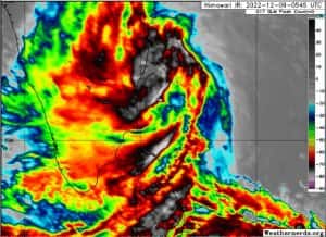 Satellite imagery shows Cyclone Mandous near the Tamil Nadu coast on 9 December morning[/caption] As per Indian Meteorological Department, the severe cyclonic storm “Mandous” over southwest Bay of Bengal moved west-northwestwards with a speed of 13 kmph during past six hours and lay centered at 05:30 hours IST of 9 December, 2022 over southwest Bay of Bengal near latitude 11.0°N and longitude 81.7°E, about 270 km North-Northeast of Trincomalee (Sri Lanka), 230 km East-Northeast of Jaffna (Sri Lanka), 200 km east of Karaikal and about 270 km South-Southeast of Chennai. It is very likely to weaken into a cyclonic storm during the afternoon of 9 December and move northwestwards and cross north Tamilnadu, Puducherry and adjoining south Andhra Pradesh coasts between Puducherry and Sriharikota around Mahabalipuram as a cyclonic storm with a maximum sustained wind speed of 65-75 kmph gusting to 85 kmph during midnight of today, the 9 December to early hours of 10 December. [caption id=“attachment_11781341” align=“alignnone” width=“269”]
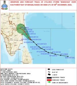 Observed and forecasted track of the cyclonic storm by IMD[/caption] Under the influence of the tropical disturbance heavy rains are already ongoing in most parts of Tamil Nadu, Chennai received 68mm rainfall ending 8:30 AM on Friday morning. Weather warnings for the southern states for the next two days: Rainfall Warning: • 9 December: Light to moderate rainfall at most places with heavy to very heavy rainfall at a few places and extremely heavy rainfall at isolated places very likely over north coastal Tamil Nadu, Puducherry and isolated heavy to very heavy rainfall likely over adjoining south Coastal Andhra Pradesh and north interior Tamilnadu and Rayalaseema. • 10 December: It is likely to reduce to Light to moderate rainfall at most places with heavy to very heavy rainfall at isolated places likely over north Tamil Nadu and Rayalaseema and south Andhra Pradesh. Wind Warning: • Southwest Bay of Bengal: Gale wind, speed reaching 85-95 kmph gusting to 105 kmph prevails over southwest Bay of Bengal. It would decrease and becoming 80-90 kmph gusting to 100 kmph during next 06 hours thereafter gradually becoming 70-80 kmph gusting to 90 kmph from today evening, 60-70 kmph gusting to 80 kmph by 10th December morning and 25-35 kmph gusting to 45 kmph by 10 December evening. • Along & off Tamil Nadu, Puducherry, south Andhra Pradesh and north SriLanka coasts: Squally wind, speed reaching 45-55 kmph gusting to 65 kmph is prevailing along & off Tamil Nadu-Puducherry-south Andhra Pradesh-north Sri Lanka coasts. It would increase and become 50-60 kmph gusting to 70 kmph during next 06 hours and 65-75 kmph gusting to 85 kmph from today, the 09th December evening till early hours of 10th December. It is likely to reduce gradually thereafter becoming 55-65 kmph gusting to 75 kmph by morning of 10th December and then to 25-35 kmph gusting to 45 kmph by 10 December evening. • Gulf of Mannar: Squally wind, speed reaching 40-50 kmph gusting to 60 kmph is prevailing over Gulf of Mannar. It would increase and become 50-60 kmph gusting to 70 kmph from today evening to early hours of 10 December and 40-50 kmph gusting to 60 kmph by 10 December morning. • Westcentral Bay of Bengal: Squally wind, speed reaching 40-50 kmph gusting to 60 kmph is likely to prevail over west-central Bay of Bengal off south Andhra Pradesh coast during next six hours and would increase gradually becoming 55-65 kmph gusting to 75 kmph from today evening to 10 December early morning and reduce thereafter gradually becoming 30-40 kmph gusting to 50 kmph by 10 December evening. [caption id=“attachment_11781401” align=“alignnone” width=“278”]
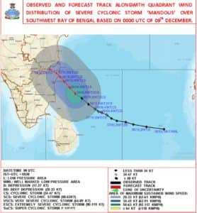 Wind warning graphics along with the track of the Cyclone Mandous[/caption] Do’s and Don’ts to follow during the cyclone warning: • Leave early before your way to high ground or shelter gets flooded • Do not delay and run the risk of being marooned • If your house is securely built on high ground take shelter in the safe part of the house. However, if asked to evacuate do not hesitate to leave the place. • Board up glass windows or put storm shutters in place. • Provide strong suitable support for outside doors. • If you do not have wooden boards handy, paste paper strips on glasses to prevent splinters. However, this may not avoid breaking windows. • Get extra food, which can be eaten without cooking. Store extra drinking water in suitably covered vessels. • If you have to evacuate the house, move your valuable articles to upper floors to minimize flood damage. • Ensure that your hurricane lantern, torches or other emergency lights are in working condition and keep them handy. • Small and loose things, which can fly in strong winds, should be stored safely in a room. • Be sure that a window and door can be opened only on the side opposite to the one facing the wind. • Make provision for children and adults requiring a special diet. • If the centre of the cyclone is passing directly over your house there will be a lull in the wind and rain lasting for half an hour or so. During this time do not go out; because immediately after that, very strong winds will blow from the opposite direction. • Switch off the electrical mains in your house. The author, better known as the Rohtak Weatherman, interprets and explains complex weather patterns. His impact-based forecasts @navdeepdahiya55 are very popular in north India. Read all the Latest News
, Trending News
,
Cricket News
, Bollywood News
, India News
and Entertainment News
here. Follow us on
Facebook
,
Twitter
and
Instagram
.
Wind warning graphics along with the track of the Cyclone Mandous[/caption] Do’s and Don’ts to follow during the cyclone warning: • Leave early before your way to high ground or shelter gets flooded • Do not delay and run the risk of being marooned • If your house is securely built on high ground take shelter in the safe part of the house. However, if asked to evacuate do not hesitate to leave the place. • Board up glass windows or put storm shutters in place. • Provide strong suitable support for outside doors. • If you do not have wooden boards handy, paste paper strips on glasses to prevent splinters. However, this may not avoid breaking windows. • Get extra food, which can be eaten without cooking. Store extra drinking water in suitably covered vessels. • If you have to evacuate the house, move your valuable articles to upper floors to minimize flood damage. • Ensure that your hurricane lantern, torches or other emergency lights are in working condition and keep them handy. • Small and loose things, which can fly in strong winds, should be stored safely in a room. • Be sure that a window and door can be opened only on the side opposite to the one facing the wind. • Make provision for children and adults requiring a special diet. • If the centre of the cyclone is passing directly over your house there will be a lull in the wind and rain lasting for half an hour or so. During this time do not go out; because immediately after that, very strong winds will blow from the opposite direction. • Switch off the electrical mains in your house. The author, better known as the Rohtak Weatherman, interprets and explains complex weather patterns. His impact-based forecasts @navdeepdahiya55 are very popular in north India. Read all the Latest News
, Trending News
,
Cricket News
, Bollywood News
, India News
and Entertainment News
here. Follow us on
Facebook
,
Twitter
and
Instagram
.
Explained: Cyclone Mandous to hit Indian coast, what are dos and don'ts to follow
Navdeep Dahiya
• December 9, 2022, 16:44:32 IST
The presence of the Kelvin wave and the arrival of Madden Julian Oscillation (MJO) in the Indian ocean spinned a tropical storm in the Bay of Bengal this week in a sudden turn of events
Advertisement
 "Explained: Cyclone Mandous to hit Indian coast, what are dos and don'ts to follow")
End of Article