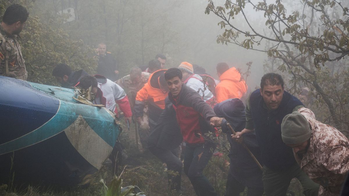
 "Rescue team works following a crash of a helicopter carrying Iran's President Ebrahim Raisi, in Varzaqan, East Azerbaijan Province, Iran, 20 May, 2024. WANA via Reuters")
In an attempt to locate the helicopter carrying Iranian president Ebrahim Raisi, which crashed in East Azerbaijan province on Sunday, 19 May, the European Union (EU) activated its emergency satellite mapping service at Iran’s request. The search and rescue operations were hampered by dense fog and low temperatures with low visibility.
Confirming this, European Commissioner for Crisis Management, Janez Lenarcic, wrote on X, “Upon Iranian request for assistance we are activating the EU’s @CopernicusEMS rapid response mapping service in view of the helicopter accident reportedly carrying the President of Iran and its foreign minister.”
A day later, he replied to his post, writing, “The provision of a @CopernicusEMS satellite mapping upon request for facilitating a search and rescue operation is not an act of political support to any regime or establishment. It is simply an expression of the most basic humanity."
On Monday morning, the helicopter was found after an extensive search. State media confirmed that Raisi along with Iranian Foreign Minister Hossein Amirabdollahian , and other officials were found dead at the crash site near the border with Azerbaijan.
The rapid mapping service is a crucial component of the Emergency Management Service (EMS), which is part of the EU’s Copernicus programme. What is this programme and how does it work?
Impact Shorts
More ShortsWhat is EU’s Copernicus programme?
Named after 15th-century scientist Nicolaus Copernicus, the programme serves as the earth observation component of the EU’s space initiative. Initially known as the Global Monitoring for Environment and Security Programme (GMES), Copernicus was launched in 1998.
The programme utilises global data from satellites, as well as ground-based, airborne, and sea-borne measurement systems, to provide environment-related information. This data is used by researchers, policymakers, public authorities, international organisations, and commercial and private users to address issues related to climate change, disaster management, agriculture, and more.
Currently, the programme is implemented by EU member states with the support of the European Space Agency (ESA) for the space component and the European Environment Agency (EEA) for the in-situ component.
Additional support is provided by the European Organisation for the Exploitation of Meteorological Satellites (EUMETSAT), the European Centre for Medium-Range Weather Forecasts (ECMWF), EU agencies, Mercator Océan, the European Environment Agency (EEA), and the Joint Research Center (JRC).
Also Read: Why politicians use helicopters despite history of crashes
The Copernicus Programme is supported by dedicated satellites known as the Copernicus Sentinel families, as well as additional Contributing Missions operated by various commercial and national agencies. Since the launch of Sentinel-1A in 2014, the EU has been working to establish a constellation of nearly 20 more satellites in orbit by 2030. This satellite data is complemented and validated by in situ data.
The programme includes six Copernicus Services, which process and analyse the full data to create value-added information, such as informative maps and data sets. These services are:
The Copernicus Atmosphere Monitoring Service
The Copernicus Marine Environment Monitoring Service
The Copernicus Land Monitoring Service
The Copernicus Climate Change Service
The Copernicus Emergency Management Service
The Copernicus Security Service
What is the Copernicus EMS that aided in Raisi’s chopper search?
The Copernicus Emergency Management Service (CEMS) has been active since 2012. “The service supports crisis managers, Civil Protection authorities and humanitarian aid actors dealing with natural disasters, man-made emergency situations, and humanitarian crises, as well as those involved in disaster risk reduction and recovery activities,” says the service’s website.
The CEMS consist of five main components:
Risk & Recovery Mapping
Rapid Mapping
Early Warning & Monitoring Systems for Forest Fires (European and Global)
Early Warning & Monitoring Systems for Floods (European and Global)
European Drought Observatory (EDO)
The CEMS covers “floods, earthquakes, landslides, severe storms, fires, technological disasters, volcanic eruptions, humanitarian crises, tsunamis.”
The EMS operates on two models: on-demand mapping and early warning and monitoring. These models provide warnings, risk assessments, and information on the impact of disasters worldwide, before, during, or after a crisis.
On-demand mapping delivers detailed information for specific emergencies, while early warning offers critical geospatial data through monitoring and forecasts for floods, droughts, and forest fires. Following Raisi’s helicopter crash, the EU activated the rapid mapping service.
Rapid Mapping delivers geospatial information within hours or days of activation to support emergency management activities immediately following a disaster. Standardised mapping products are provided to:
Ascertain the situation before the event (reference product)
Roughly identify and assess the most affected areas (first estimate product)
Assess the geographical extent of the event (delineation product)
Evaluate the severity of the damage resulting from the event (grading product)
Risk and Recovery Mapping provides on-demand geospatial information to support disaster management activities not related to immediate response. This includes activities focused on prevention, preparedness, disaster risk reduction, and recovery phases. There are three broad product categories:
Reference Maps
Pre-disaster Situation Maps
Post-disaster Situation Maps
Who can access & activate the Copernicus EMS?
The EMS Mapping component can be activated for any part of the world by or through an Authorised User. Authorised Users include National Focal Points in EU Member States and Copernicus Participating Countries, as well as EU Delegations worldwide.
Activations can also be triggered directly by or, for countries without a National Focal Point, through the Emergency Response Coordination Centre (ERCC) of the European Commission’s Directorate General of Humanitarian Aid & Civil Protection. In all cases, a Service Request Form, available on the Copernicus EMS website, must be completed.
EFFIS (European Forest Fire Information System) and GWIS (Global Wildfire Information System): These systems are accessible online to both users and the general public without the need for a password or registration.
GloFAS (Global Flood Awareness System): Access requires creating a free account.
EFAS (European Flood Awareness System): Information is restricted, but access can be provided upon request.
Also Read: Why many in Iran are celebrating Ebrahim Raisi’s death
Anmol is a Senior Sub-Editor with Firstpost. He likes to cover stories that amuse him, generally revolving around international polity, Indian foreign policy, human interest, environment and even the politically-charged election cycles in India. He has far too many disparate interests with a constant itch for travel. Having visited fourteen states in the Indian subcontinent, he is always on the lookout for opportunities to add more to the list. He enjoys watching Football, Tennis and F1 purely as a sports enthusiast.