
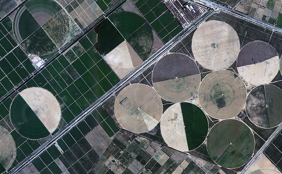
 "Spellbinding images captured by ISRO's Earth observation satellites, India's \"eyes in the skies\"")
[caption id=“attachment_3880649” align=“aligncenter” width=“940”] 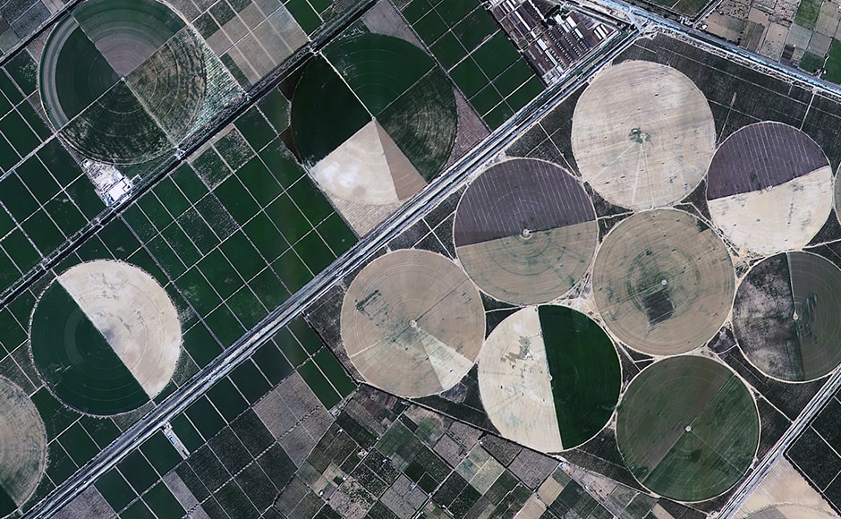 Alexandria in Egypt imaged by the CartoSat 2 series satellite. Image: ISRO[/caption] [caption id=“attachment_3880651” align=“aligncenter” width=“940”] 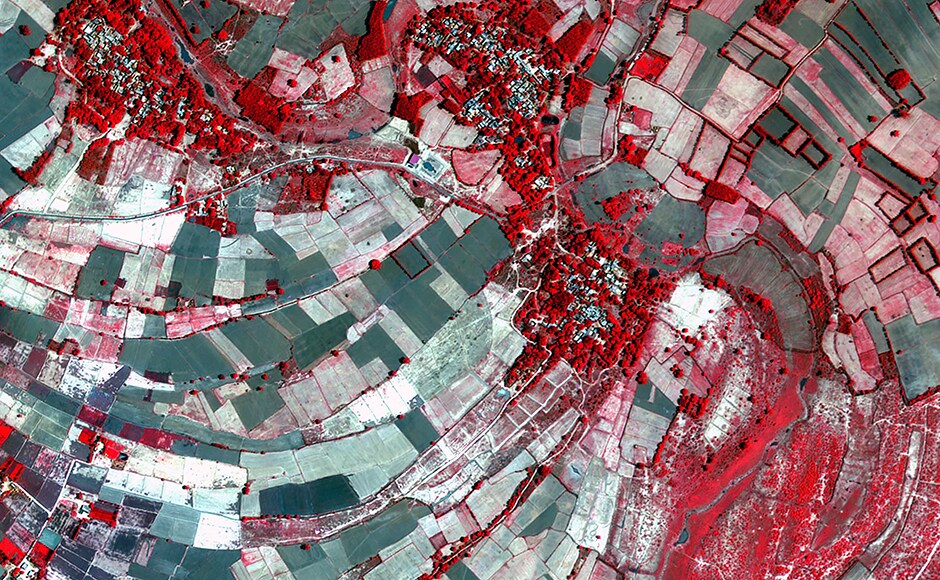 Bhiduriya in UP, India imaged by the CartoSat 2 series satellite. Image: ISRO[/caption] [caption id=“attachment_3880653” align=“aligncenter” width=“940”]  BKC in Mumbai and the Mithi river imaged by the CartoSat 2 series satellite. Image: ISRO[/caption] [caption id=“attachment_3880655” align=“aligncenter” width=“940”]  Doha, Qatar imaged by the CartoSat 2 series satellite. Image: ISRO[/caption] [caption id=“attachment_3880657” align=“aligncenter” width=“940”]  Another image of Doha, Qatar imaged by the CartoSat 2 series satellite. Image: ISRO[/caption] [caption id=“attachment_3880659” align=“aligncenter” width=“940”]  The Earth captured by the InSat 3DR. Image: ISRO[/caption] [caption id=“attachment_3880661” align=“aligncenter” width=“940”]  Koila, Gayanpur in UP imaged by the CartoSat 2 series satellite. Image: ISRO[/caption] [caption id=“attachment_3880663” align=“aligncenter” width=“940”]  Daman imaged by the ResourceSat 2A. Image: ISRO[/caption] [caption id=“attachment_3880665” align=“aligncenter” width=“940”]  Mt. Sinabung in Indonesia captured by the RiSat-1. The blue areas represent fresh lava flows.[/caption] [caption id=“attachment_3880667” align=“aligncenter” width=“940”]  The Howrah bridge imaged by the RiSat-1[/caption] [caption id=“attachment_3880669” align=“aligncenter” width=“940”]  A global wind map captured by the ScatSat-1[/caption] [caption id=“attachment_3880677” align=“aligncenter” width=“940”]  The Antartic imaged by the ScatSat-1[/caption] [caption id=“attachment_3880679” align=“aligncenter” width=“940”]  The Arctic circle imaged by the ScatSat-1. Image: ISRO[/caption]
The images were captured by InSat 3DR, the RiSat-1, ScatSat-1, ResourceSat-2A and the CartoSat 2 series satellites
Advertisement
End of Article
 "‘I’d love to do it’: Trump refuses to rule out third term — despite constitutional limit")
 "What is the ‘Golden Fleet’ of navy ships that Trump wants to counter China with?")
 "‘Ramayan country’: Why Trinidad and Tobago wants to build a large Ram temple")
 "How China's rare earths choke changed America's trade deals")


](https://images.firstpost.com/wp-content/uploads/2017/08/alexandria-egyptcartosat-2series.jpg)
](https://images.firstpost.com/wp-content/uploads/2017/08/bhiduriya-up-cartosat-2-series.jpg)
](https://images.firstpost.com/wp-content/uploads/2017/08/BKC-Block-mithi-river-cartosat-2-series-satellite.jpg)
](https://images.firstpost.com/wp-content/uploads/2017/08/dohaqatar-cartosat-2series.jpg)
](https://images.firstpost.com/wp-content/uploads/2017/08/dohaqatar-cartosat-2-series.jpg)
](https://images.firstpost.com/wp-content/uploads/2017/08/insat-3dr.jpg)
](https://images.firstpost.com/wp-content/uploads/2017/08/isro-cartosat-7.jpg)
](https://images.firstpost.com/wp-content/uploads/2017/08/resource-sat-2a-daman.jpg)
](https://images.firstpost.com/wp-content/uploads/2017/08/risat-1-fresh-lava-flows-Mt.-Sinabung-indonesia.bmp)
](https://images.firstpost.com/wp-content/uploads/2017/08/risat-1-howrah-bridge.jpg)
](https://images.firstpost.com/wp-content/uploads/2017/08/scatsat-1-global-winds.jpg)
](https://images.firstpost.com/wp-content/uploads/2017/08/scatsat-1-antartic.jpg)
](https://images.firstpost.com/wp-content/uploads/2017/08/scatsat-1-arctic.jpg)