
 "Google creates virtual tour of tsunami-damaged buildings in Japan")
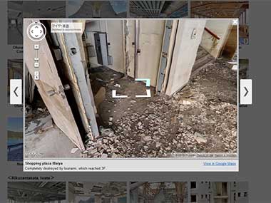
Google today released panoramic photographs of 34 facilities that were hit by the 11 March earthquake and tsunami in Japan last year in an effort to preserve images of the damage caused.
Utilizing its “Street View” technology which provides panoramic photos of streets via the Internet, Google’s website “ Memories for the Future” displays photos of remains such as schools and a fish market, including the exteriors and interiors of the buildings.
“We have taken photos of inside and outside of buildings with a 360-degree view,” said Kei Kawai, Google’s group product manager who led the project.Visitors to the website “can feel as if they are inside the buildings,” he told a news conference in Tokyo.
[caption id=“attachment_547754” align=“alignleft” width=“380”]  A screengrab of the Google Project.[/caption]
The facilities include the former city office of Rikuzentakata, a coastal city in Iwate Prefecture, as well as an elementary school in Namie, Fukushima Prefecture, where the entry of people is restricted due to the nuclear crisis at the Fukushima Daiichi power plant.
Google already shows photos taken from public streets in the disaster-hit areas. Users can click on the image, to go up, down, left and right and thus experience the complete 360 degree view on these photos.
The company cooperated with local governments to take pictures of facilities in Ofunato, Kamaishi, Rikuzentakata in Iwate and Namie, Fukushima Prefecture, before they are scrapped, the company said.
Google said it plans to add more pictures of facilities in the disaster-hit areas, while it aims to follow up on reconstruction efforts.
PTI
 "Israel targets top Hamas leaders in Doha; Qatar, Iran condemn strike as violation of sovereignty")
 "Nepal: Oli to continue until new PM is sworn in, nation on edge as all branches of govt torched")
 "Who is CP Radhakrishnan, India's next vice-president?")
 "Israel informed US ahead of strikes on Hamas leaders in Doha, says White House")


](https://images.firstpost.com/wp-content/uploads/2012/12/Google_kyoto_Screengrab.jpg)